
Oytak
Oytak
奥依塔克镇 Aoyitake Auyitagh; Oytag | |
|---|---|
 Oytak Location of the town | |
| Coordinates: 39°00′15″N 75°33′24″E / 39.0041104129°N 75.5566592011°E | |
| Country | People's Republic of China |
| Autonomous region | Xinjiang |
| Autonomous prefecture | Kizilsu |
| County | Akto |
| Area | |
| • Total | 1,537 km2 (593 sq mi) |
| Population (2017)[1] | |
| • Total | 5,093 |
| Time zone | UTC+8 (China Standard Time) |
| Area code | 653022 101 |
| Website | www.xjakt.gov.cn/ |
Oytak Town (Chinese: 奥依塔克镇; pinyin: Àoyītǎkè Zhèn) is a town of Akto County in Xinjiang Uygur Autonomous Region, China. Located in the middle of the northeast of the county, the town covers an area of 1,537 square kilometers with a population of 5,093 (as of 2017). It has 4 villages[2] with 16 villagers' groups under its jurisdiction, its seat is at Tokkuzotak (托库孜乌塔克).[3]
Name[edit]
The name of Oytak is from Kyrgyz language, meaning "sunken ravine" (凹山沟), or "a lowland in mountains" (山涧洼地) from the old Turkic language.[4] It is named after the geologically famous Oytak Valley (奥依塔克沟) in the land.[3] The name of the town is also spelled Oytag.[5][6]
Geography[edit]

The town of Oytak is located between 75°58′~76°03′ east longitude and 39°12′- 39°16′ north latitude, 50 kilometers southwest of the county seat Akto Town. The Karakoram Highway runs through the town north to south, with convenient transportation. The area has a maximum length of 58 kilometers from west to east, a maximum length of 52 kilometers from north to south, and a total area of 1,537 square kilometers. Oytak is a semi-agricultural and semi-pastoral town with an area of 842.58 hectares of arable land, 49.21 hectares of orchard and 48.92 hectares of forest land. Oytak is a temperate continental dry climate with cool weather. The annual average temperature is 7.8 °C, the average temperature in January is −8.1 °C, the average temperature in July is 20.8 °C, and the frost-free period is 130–200 days.[1]
Resources[edit]
The main water system is the Gez River (盖孜河), the water resources are richer in the town. The town's economy is dominated by animal husbandry, and farming and animal husbandry are run. The land on both sides of the Gez River Valley is more fertile and flat. The main crops are wheat and corn. There are precious animals such as snow chicken and mongolian gazelle in the territory, and there are mineral resources such as iron, copper, gold, coal, oil shale, limestone, gypsum, clay and zeolite. The tourism resources are well-known Auyitagh Forest Park (奥依塔克森林公园), with glaciers, scenery and cool climate.[7]
-
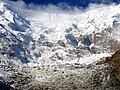 Snow mountains and glaciers, close to Karakoram Highway
 -

-
 mountains
 -
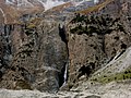 mountains
 -
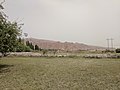 grassland in Oytak
 -
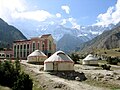 a hotel, close to Karakoram Highway


Administrative divisions[edit]
The town has 4 villages under its jurisdiction.[2][8]
- Atoynak (阿特奥依纳克村)
- Oytak (奥依塔克村)
- Pilal (皮拉勒村)
- Qalmaerik (恰勒玛艾日克村)
- Tokkuzotak (托库孜乌塔克)
- Oytag aygzu (奥依塔克艾格孜)
See also[edit]
References[edit]
- ^ a b c 奥依塔克镇(概况). xjakt.gov.cn. 4 June 2018. Retrieved 7 November 2019.
- ^ a b 2018年奥依塔克镇行政区划代码. National Bureau of Statistics of China. 31 October 2018. Retrieved 1 November 2019.
- ^ a b 阿克陶县行政区划和居民地名称. xjkz.gov.cn. 4 May 2018. Archived from the original on 28 April 2021. Retrieved 8 November 2019.
- ^ 新疆各地地名的由来及含义. sohu.com. 4 September 2018. Retrieved 6 November 2019.
- ^ Xie Yuzhong 解玉忠 (2003). 地名中的新疆 (in Simplified Chinese). Ürümqi: 新疆人民出版社. p. 191. ISBN 7-228-08004-1.
- ^ Zhong Xingqi 钟兴麒, ed. (July 2008). 西域地名考录 (in Simplified Chinese). Beijing: 国家图书馆出版社. p. 73. ISBN 978-7-5013-3628-9.
- ^ 新疆喀什奥依塔克森林公园风景区介绍. xjlxw.com. 6 April 2019. Retrieved 7 November 2019.
- ^ 1997年阿克陶县行政区划 [1997 Akto County Administrative Divisions] (in Simplified Chinese). XZQH.org. 31 December 2010. Retrieved 28 August 2020.
奥依塔克镇 1962年成立奥依塔克公社,1967年更名前进公社,1984年改设奥依塔克镇。位于县城西南156千米。面积1537平方千米,人口0.4万,主要为维吾尔族。辖4个行政村(按序数命名)。