
Palais des Beaux Arts, Vienna
The Palais des Beaux Arts is a residential and office building at Löwengasse 47-47A in Vienna's third district, Landstraße. The building has housed the embassies of the Republic of Lithuania and the Republic of Moldova since 1994. The building was erected between 1908 and 1909 by Anton and Josef Drexler, who also designed several houses on Rudolf-von-Alt-Platz and contributed other designs to the surrounding Weißgerberviertel quarter of the district. The building was originally built as home to Chic Parisien, a center for fashion.
Design[edit]
Its architecture features an original combination of elements of late Historicism and decorative motifs of West European Art Nouveau.[1]
Austrian architecture critic Friedrich Achleitner lauded the structure for its rational ground plan and its contrasting, almost Baroque, abundance of decoration. He considered this layout noteworthy because it made the building easily adjustable.[2]
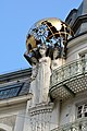
The structure is dominated by a corner tower that resembles an inserted hinge, flanked by female figures holding globes. The interior features a vestibule decorated with floral stucco and reliefs of female figures in the staircase.[3]
History[edit]
The building has been home to a varied exhibition program since 2014,[4] where alternating arts projects are displayed via Wi-Fi in and around the Palais des Beaux Arts, for visitors using smartphones and tablets.[5]
Images[edit]
-
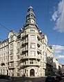 Palais des Beaux Arts, View of corner tower with main entrance
 -
 Figures with globe, Palais des Beaux Arts
 -
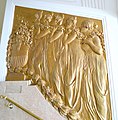 Relief of female figures, Vestibule, Palais des Beaux Arts
 -
 Detail of Paracelsusgasse façade, Palais des Beaux Arts
 -
 Group of figures on the north-western façade, Palais des Beaux Arts


References[edit]
- ^ Czeike, Felix. Historisches Lexikon Wien, Volume 4. p. 480.
- ^ Achleitner, Friedrich (1990). Österreichische Architektur im 20. Jahrhundert, Vol. III/1. Salzburg and Vienna: Residenz Verlag. p. 127.
- ^ Dehio Wien II-IX, XX. p. 119.
- ^ Rudolf, Tanja (June 21, 2014). "Fidel durch den Dritten". Die Presse.
- ^ Bernard Garnicnig über die "virtuelle Galerie" im Wiener Palais des Beaux Arts, Ö1 Leporello, January 13, 2015.