
Pelion Gap
| Pelion Gap | |
|---|---|
 Wooden platform at Pelion Gap | |
| Elevation | 1,126 m (3,694 ft)[1] or |
| Location | Cradle Mountain-Lake St Clair National Park, Tasmania, Australia, Approximately mid-distance along the Overland Track |
| Coordinates | 41°51′52.52″S 146°3′32.26″E / 41.8645889°S 146.0589611°E |
Pelion Gap (1,126 metres (3,694 ft)[1] or 1,113 metres (3,652 ft)[2]) is the mountain pass between Mount Doris and Mount Ossa to the south and Mount Pelion East to the north through which the Overland Track in Tasmania passes.
This is a popular resting place for walkers on the Overland Track as it is the highest point between Pelion Hut and Kia Ora Hut, is approximately halfway between the two and also has a large wooden platform surrounded by log seating.
Pelion Gap is also the starting point for two side-trip climbs; Mount Ossa and Mount Pelion East.
-
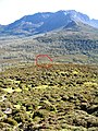 Looking down on Pelion Gap with Mount Doris in the foreground and Mount Ossa in the background
 -
 Sign at Pelion Gap


See also[edit]
References[edit]
- ^ a b "LISTmap (Pelion Gap)". Tasmanian Government Department of Primary Industries and Water. Retrieved 29 February 2008.
- ^ a b Text on sign at Pelion Gap
This Central Highlands, Tasmania geography article is a stub. You can help Wikipedia by expanding it. |