
Piccadilly Gardens tram stop
Piccadilly Gardens | ||||||||||||||||||||||||||||||||||||||||||||||||||||||||||||||||||||||||||||||||||||||||||||||||||||||||||||||||||||||||||||||
|---|---|---|---|---|---|---|---|---|---|---|---|---|---|---|---|---|---|---|---|---|---|---|---|---|---|---|---|---|---|---|---|---|---|---|---|---|---|---|---|---|---|---|---|---|---|---|---|---|---|---|---|---|---|---|---|---|---|---|---|---|---|---|---|---|---|---|---|---|---|---|---|---|---|---|---|---|---|---|---|---|---|---|---|---|---|---|---|---|---|---|---|---|---|---|---|---|---|---|---|---|---|---|---|---|---|---|---|---|---|---|---|---|---|---|---|---|---|---|---|---|---|---|---|---|---|---|
| Metrolink station | ||||||||||||||||||||||||||||||||||||||||||||||||||||||||||||||||||||||||||||||||||||||||||||||||||||||||||||||||||||||||||||||
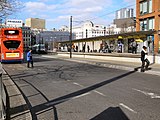
 Piccadilly Gardens tram stop in February 2018 | ||||||||||||||||||||||||||||||||||||||||||||||||||||||||||||||||||||||||||||||||||||||||||||||||||||||||||||||||||||||||||||||
| General information | ||||||||||||||||||||||||||||||||||||||||||||||||||||||||||||||||||||||||||||||||||||||||||||||||||||||||||||||||||||||||||||||
| Location | Piccadilly Gardens, Manchester England | |||||||||||||||||||||||||||||||||||||||||||||||||||||||||||||||||||||||||||||||||||||||||||||||||||||||||||||||||||||||||||||
| Coordinates | 53°28′49″N 2°14′13″W / 53.4803°N 2.2370°W | |||||||||||||||||||||||||||||||||||||||||||||||||||||||||||||||||||||||||||||||||||||||||||||||||||||||||||||||||||||||||||||
| Grid reference | SJ843982 | |||||||||||||||||||||||||||||||||||||||||||||||||||||||||||||||||||||||||||||||||||||||||||||||||||||||||||||||||||||||||||||
| Line(s) | Piccadilly spur | |||||||||||||||||||||||||||||||||||||||||||||||||||||||||||||||||||||||||||||||||||||||||||||||||||||||||||||||||||||||||||||
| Platforms | 2 (island) | |||||||||||||||||||||||||||||||||||||||||||||||||||||||||||||||||||||||||||||||||||||||||||||||||||||||||||||||||||||||||||||
| Other information | ||||||||||||||||||||||||||||||||||||||||||||||||||||||||||||||||||||||||||||||||||||||||||||||||||||||||||||||||||||||||||||||
| Status | In operation | |||||||||||||||||||||||||||||||||||||||||||||||||||||||||||||||||||||||||||||||||||||||||||||||||||||||||||||||||||||||||||||
| Fare zone | 1 | |||||||||||||||||||||||||||||||||||||||||||||||||||||||||||||||||||||||||||||||||||||||||||||||||||||||||||||||||||||||||||||
| History | ||||||||||||||||||||||||||||||||||||||||||||||||||||||||||||||||||||||||||||||||||||||||||||||||||||||||||||||||||||||||||||||
| Opened | 27 April 1992 | |||||||||||||||||||||||||||||||||||||||||||||||||||||||||||||||||||||||||||||||||||||||||||||||||||||||||||||||||||||||||||||
| Original company | Metrolink | |||||||||||||||||||||||||||||||||||||||||||||||||||||||||||||||||||||||||||||||||||||||||||||||||||||||||||||||||||||||||||||
| ||||||||||||||||||||||||||||||||||||||||||||||||||||||||||||||||||||||||||||||||||||||||||||||||||||||||||||||||||||||||||||||
| Location | ||||||||||||||||||||||||||||||||||||||||||||||||||||||||||||||||||||||||||||||||||||||||||||||||||||||||||||||||||||||||||||||
 | ||||||||||||||||||||||||||||||||||||||||||||||||||||||||||||||||||||||||||||||||||||||||||||||||||||||||||||||||||||||||||||||
Piccadilly Gardens is a tram stop in Zone 1 of Greater Manchester's Metrolink light rail system. It is located beside Piccadilly Gardens in Manchester city centre, and serves both as a transport hub (by integrating with the adjacent Manchester Piccadilly Gardens bus station), and interchange station (which can be used for changing between Metrolink lines).[1]
Piccadilly Gardens tram stop opened on 27 April 1992, as part of Metrolink's Phase 1. The station was rebuilt during 2009 with a wider platform and a new canopy, reopening on 2 November 2009. The stop is one of the most used on the Metrolink network.[2]
History[edit]
In 1931, a new bus station was opened on Parker Street on the former site of the Manchester Royal Infirmary, providing a central transport interchange for bus passengers.[3] In 1945, adjacent site was landscaped as an ornamental sunken garden and named Piccadilly Gardens.[4]
In 1991, construction work began on a new light rail transport network, Manchester Metrolink. New tram lines were laid along the southern and western sides of Piccadilly Gardens, and a new tram stop constructed alongside the bus station, providing an inter-modal exchange between tram and bus.[5]
Services[edit]
Services run every twelve minutes on each route at most operating times.
| Preceding station | Following station | |||
|---|---|---|---|---|
| Market Street towards Bury
|
Bury–Piccadilly | Piccadilly Terminus
| ||
| St Peter's Square towards Altrincham
|
Altrincham–Piccadilly | |||
| Altrincham–Etihad Campus (evenings and Sundays only) | Piccadilly towards Etihad Campus
| |||
| St Peter's Square towards MediaCityUK
|
MediaCityUK–Etihad Campus (peak only) | |||
| St Peter's Square towards Eccles
|
Eccles–Ashton (peak only) | Piccadilly towards Ashton-under-Lyne
| ||
| Eccles–Ashton via MediaCityUK (off-peak only) | ||||
Gallery[edit]
-
 Piccadilly Gardens bus station in 1976
 -
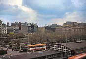
 The future site of Piccadilly Gardens tram stop, photographed in 1989
 -
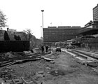 Construction of the Manchester Metrolink lines at Piccadilly Gardens in 1991
 -
 Construction of Piccadilly Gardens Metrolink platforms in 1991
 -
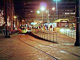 Piccadilly Gardens tram stop in December 2013.
 -
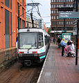 An older T-68 tram at Piccadilly Gardens tram stop in 2005.
 -
 Inter-modal exchange at the bus station
 -
 Map of Manchester City Centre Metrolink stops
_-_geograph.org.uk_-_2266502.jpg)


References[edit]
- ^ TfGM (2013). "Services Map" (PDF). metrolink.co.uk. Retrieved 25 February 2013.
- ^ "Transport Statistics Greater Manchester 2017 Public Transport Section". TfGM. 5 December 2019. Retrieved 14 December 2019.
- ^ A Hundred Years of Road Passenger Transport in Manchester. 1935. p. 30. Retrieved 6 August 2021.
- ^ Glinert, Ed (24 April 2008). The Manchester Compendium: A Street-by-Street History of England's Greatest Industrial City. Penguin Books Limited. ISBN 978-0-14-102930-6. Retrieved 7 August 2021.
- ^ Senior, John A.; Ogden, Eric (1992). Metrolink. Transport Publishing. ISBN 978-0-86317-155-0.
External links[edit]
Manchester railways |
|---|
City Centre and North
Past, present and future |
| Tram stops |
|   | ||||||||||||||||||||||||
|---|---|---|---|---|---|---|---|---|---|---|---|---|---|---|---|---|---|---|---|---|---|---|---|---|---|---|
| Operations |
| |||||||||||||||||||||||||
| History (Timeline) |
| |||||||||||||||||||||||||
| Proposed developments |
| |||||||||||||||||||||||||