
Portal:Kent/Sandbox
DesktopMobile
Test of: Transclude files as random slideshow/sandbox
-

-
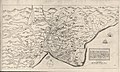 A map of Romney Marsh "The history of imbanking and drayning" by William Dugdale (1662). (from Kent)
 -
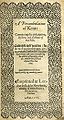 Title page of William Lambarde's Perambulation of Kent (completed in 1570 and published in 1576), a historical description of Kent and the first published county history (from Kent)
 -
 The coat of arms of Kent County Council (from Kent)
 -

-
-
-
 Hand-drawn map of Kent, Sussex, Surrey and Middlesex from 1575. (from Kent)
 -
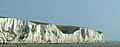 The White Cliffs of Dover (from Kent)
 -
 Canterbury Cathedral (from Kent)
 -
-
 Geological cross-section of Kent, showing how it relates to major towns (from Kent)
 -
 An early mention of Kent in the Anglo-Saxon Chronicle between 11th and 12th centuries (from Kent)
 -

-
 View of the White Cliffs of Dover from France (from Kent)

.jpg)


Apr2006.jpg)


Test of: Transclude linked excerpts as random slideshow/sandbox
-

-
Gavelkind (/ˈɡævəlkaɪnd/) was a system of land tenure chiefly associated with the Celtic law in Ireland and Wales and with the legal traditions of the English county of Kent. (Full article...)
-
Holcombe Hockey Club is a field hockey club based in Rochester, Kent, England. The home ground is located at Holcombe Park, where there is a water-based pitch, a sand-based pitch and a clubhouse. The club was formed in 1999/2000 from a merger of clubs in the area. (Full article...)
-
William Lambarde (18 October 1536 – 19 August 1601) was an English antiquarian, writer on legal subjects, and politician. He is particularly remembered as the author of A Perambulation of Kent (1576), the first English county history; Eirenarcha (1581), a widely read manual on the office and role of justice of the peace; and Archeion (completed c.1591, though not published until 1635), a discourse that sought to trace the Anglo-Saxon roots of English common law, prerogative and government. (Full article...)
-
The Cantiaci or Cantii were an Iron Age Celtic people living in Britain before the Roman conquest, and gave their name to a civitas of Roman Britain. They lived in the area now called Kent, in south-eastern England. Their capital was Durovernum Cantiacorum, now Canterbury. (Full article...)
-
An episcopal see is, in a practical use of the phrase, the area of a bishop's ecclesiastical jurisdiction. (Full article...)
-
Kent was a parliamentary constituency covering the county of Kent in southeast England. It returned two "knights of the shire" (Members of Parliament) to the House of Commons by the bloc vote system from the year 1290. Members were returned to the Parliament of England until the Union with Scotland created the Parliament of Great Britain in 1708, and to the Parliament of the United Kingdom after the union with Ireland in 1801 until the county was divided by the Reform Act 1832. (Full article...)
-
The White Cliffs of Dover are the region of English coastline facing the Strait of Dover and France. The cliff face, which reaches a height of 350 feet (110 m), owes its striking appearance to its composition of chalk accented by streaks of black flint, deposited during the Late Cretaceous. The cliffs, on both sides of the town of Dover in Kent, stretch for eight miles (13 km). The White Cliffs of Dover form part of the North Downs. A section of coastline encompassing the cliffs was purchased by the National Trust in 2016. (Full article...)
-
Lympne (/lɪm/), formerly also Lymne, is a village on the former shallow-gradient sea cliffs above the expansive agricultural plain of Romney Marsh in Kent. The settlement forms an L shape stretching from Port Lympne Zoo via Lympne Castle facing Lympne Industrial Park then via the main settlement to Newingreen in the north, centred 11 km (7 mi) west of Folkestone, 2.3 mi (3.7 km) west of Hythe and 13 km (8.1 mi) ESE of Ashford. (Full article...)
-
The counties of England are divisions of England. Counties have been used as administrative areas in England since Anglo-Saxon times. There are two main legal definitions of the counties in modern usage: the 84 counties for the purposes of local government, and the 48 counties for the purposes of lieutenancy, also termed the ceremonial counties. (Full article...)
-
The British Grand Prix is a Grand Prix motor racing event organised in the United Kingdom by Motorsport UK. First held by the Royal Automobile Club (RAC) in 1926, the British Grand Prix has been held annually since 1948 and has been a round of the FIA Formula One World Championship every year since 1950. In 1952, following the transfer of the lease of the Silverstone Circuit to the British Racing Drivers' Club, the RAC delegated the organisation of races held at Silverstone to the BRDC, and those held at Aintree to the British Automobile Racing Club. This arrangement lasted until the RAC created the Motor Sports Association in the late 1970s and it reclaimed organising control of the event. The RAC MSA was renamed Motorsport UK in 2019 when it formally split from the RAC. (Full article...)
-
In lithostratigraphy, coal measures are coal-bearing strata, with the term typically applied to European units of the Upper Carboniferous System. (Full article...)
-
BBC South East is the BBC English region serving Kent, East Sussex (including the City of Brighton and Hove), parts of West Sussex and Surrey. (Full article...)
-
First-class cricket, along with List A cricket and Twenty20 cricket, is one of the highest-standard forms of cricket. A first-class match is one of three or more days' scheduled duration between two sides of eleven players each and is officially adjudged to be worthy of the status by virtue of the standard of the competing teams. Matches must allow for the teams to play two innings each, although in practice a team might play only one innings or none at all. (Full article...)
-
Oxford University Press (OUP) is the publishing house of the University of Oxford. It is the largest university press in the world. The first book was printed in Oxford in 1478, with the Press officially granted the legal right to print books by decree in 1586. It is the second oldest university press after Cambridge University Press, which was founded in 1534. (Full article...)
-
The Paleolithic or Palaeolithic (/ˌpeɪlioʊˈlɪθɪk, ˌpæli-/ PAY-lee-oh-LITH-ik, PAL-ee-), also called the Old Stone Age (from Ancient Greek παλαιός (palaiós) 'old', and λίθος (líthos) 'stone'), is a period in human prehistory that is distinguished by the original development of stone tools, and which represents almost the entire period of human prehistoric technology. It extends from the earliest known use of stone tools by hominins, c. 3.3 million years ago, to the end of the Pleistocene, c. 11,650 cal BP. (Full article...)
-
The Kent Coalfield is a coalfield in the eastern part of the English county of Kent. The Coalfields Trust defines the Kent Coalfield as the wards of Barham Downs and Marshside in the Canterbury district, and the wards of Aylesham, Eastry, Eythorne & Shepherdswell, Middle Deal & Sholden, Mill Hill and North Deal in the Dover district. (Full article...)
-
The River Stour (/ˈstaʊər/, rhymes with "hour") is a river in Kent, England that flows into the North Sea at Pegwell Bay. Above Plucks Gutter, where the Little Stour joins it, the river is normally known as the Great Stour. The upper section of the river, above its confluence with the East Stour at Ashford is sometimes known as the Upper Great Stour or West Stour. In the tidal lower reaches, the artificial Stonar Cut short cuts a large loop in the natural river. (Full article...)
-
Portsmouth (/ˈpɔːrtsməθ/ ⓘ PORTS-məth) is a port city and unitary authority in Hampshire, England. Most of Portsmouth is located on Portsea Island, off the south coast of England in the Solent. This means Portsmouth is the only English city not located primarily on the mainland. Located 74 miles (119 km) south-west of London, 50 miles (80 km) west of Brighton and Hove, and 22 miles (35 km) south-east of Southampton; Portsmouth is part of the South Hampshire conurbation. It is the most densely populated city in the United Kingdom, with a population last recorded at 208,100. (Full article...)
-
The University of Kent (formerly the University of Kent at Canterbury, abbreviated as UKC) is a semi-collegiate public research university based in Kent, United Kingdom. The university was granted its royal charter on 4 January 1965 and the following year Princess Marina, Duchess of Kent, was formally installed as the first Chancellor. (Full article...)
-
High Speed 1 (HS1), legally the Channel Tunnel Rail Link (CTRL), is a 109.9-kilometre (68.3-mile) high-speed railway linking London with the Channel Tunnel. (Full article...)
-
Maidstone is the largest town in Kent, England, of which it is the county town. Maidstone is historically important and lies 32 miles (51 km) east-south-east of London. The River Medway runs through the centre of the town, linking it with Rochester and the Thames Estuary. Historically, the river carried much of the town's trade as the centre of the agricultural county of Kent, which is known as the Garden of England. There is evidence of settlement in the area dating back before the Stone Age. The town, part of the borough of Maidstone, had an approximate population of 100,000 in 2019. Since World War II, the town's economy has shifted from heavy industry towards light industry and services. (Full article...)
-
Sittingbourne is an industrial town in the Swale district, in Kent, southeast England, 17 miles (27 km) from Canterbury and 45 miles (72 km) from London, beside the Roman Watling Street, an ancient British trackway used by the Romans and the Anglo-Saxons. (Full article...)
-
A census of the population of the United Kingdom is taken every ten years. The 2011 census was held in all counties of the UK on 27 March 2011. It was the first UK census which could be completed online via the Internet. The Office for National Statistics (ONS) is responsible for the census in England and Wales, the General Register Office for Scotland (GROS) is responsible for the census in Scotland, and the Northern Ireland Statistics and Research Agency (NISRA) is responsible for the census in Northern Ireland. (Full article...)
