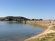
Proserpina Dam
| Proserpina Dam | |
|---|---|
 | |
| Location | Mérida, Extremadura, Spain |
| Coordinates | 38°58′10″N 6°21′59″W / 38.969544°N 6.366433°W |
| Opening date | 1st–2nd century |
| Dam and spillways | |
| Impounds | Las Pardillas (Guadiana basin) |
| Height | 12 m |
| Length | 427.8 m |
| Width (base) | 5.9 m |
| Official name | Proserpina Dam |
| Type | Cultural |
| Criteria | iii, iv |
| Designated | 1993 (17th session) |
| Part of | Archaeological Ensemble of Mérida |
| Reference no. | 664-014 |
| Region | Europe and North America |
| Official name | Pantano de Proserpina |
| Type | Non-movable |
| Criteria | Monument |
| Designated | 13 December 1912 |
| Reference no. | RI-51-0000114 |

The Proserpina Dam is a Roman gravity dam in Mérida, Extremadura, Spain, dating to the 1st or 2nd century AD. It was built as part of the infrastructure which supplied the city of Emerita Augusta with water.
After the fall of the Roman Empire, the Milagros aqueduct leading to the city fell into decay, but the earth dam with retaining wall is still in use.[1]
Conservation[edit]
It is also part of the Archaeological Ensemble of Mérida, an UNESCO World Heritage Site since 1993.[2]
See also[edit]
- List of Roman dams and reservoirs
- Roman architecture
- Roman engineering
- List of Bien de Interés Cultural in the Province of Badajoz
Notes[edit]
References[edit]
- Arenillas Parra, Miguel; Castillo, Juan C. (2003), "Dams from the Roman Era in Spain. Analysis of Design Forms (with Appendix)", 1st International Congress on Construction History [20th–24th January], Madrid
Further reading[edit]
- Aranda Gutiérrez, Fernando (2006), Las presas de abastecimiento en el marco de la ingeniería hidráulica romana. Los casos de Proserpina y Cornalbo (PDF)[permanent dead link]
- Arenillas Parra, Miguel; Díaz-Guerra Jaén, Carmen; Cortés Gimeno, Rafael (2002), La presa romana de Proserpina, archived from the original on 19 August 2003, retrieved 24 October 2009
- Hodge, A. Trevor (1992), Roman Aqueducts & Water Supply, London: Duckworth, pp. 87–89, ISBN 0-7156-2194-7
- Schnitter, Niklaus (1978), "Römische Talsperren", Antike Welt, 8 (2): 25–32 (28f.)
- Smith, Norman (1971), A History of Dams, London: Peter Davies, pp. 44–47, ISBN 0-432-15090-0
External links[edit]
 Media related to Proserpina Dam at Wikimedia Commons


