Ptakowice, Opole Voivodeship
Ptakowice | |
|---|---|
Village | |
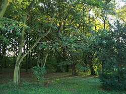
 Park in Ptakowice | |
| Coordinates: 50°45′N 17°33′E / 50.750°N 17.550°E | |
| Country | |
| Voivodeship | Opole |
| County | Brzeg |
| Gmina | Lewin Brzeski |
| Time zone | UTC+1 (CET) |
| • Summer (DST) | UTC+2 (CEST) |
| Vehicle registration | OB |
| Voivodeship roads | |
Ptakowice [ptakɔˈvit͡sɛ] is a village in the administrative district of Gmina Lewin Brzeski, within Brzeg County, Opole Voivodeship, in southern Poland.[1] It lies approximately 5 kilometres (3 mi) west of Lewin Brzeski, 14 km (9 mi) south of Brzeg, and 29 km (18 mi) west of the regional capital Opole.
The name of the village is of Polish origin and comes from the word ptak, which means "bird".[2]
Transport[edit]
The Voivodeship road 458 runs through Ptakowice and the A4 motorway runs nearby, south of the village.
References[edit]
- ^ "Central Statistical Office (GUS) – TERYT (National Register of Territorial Land Apportionment Journal)" (in Polish). 2008-06-01.
- ^ Adamy, Heinrich (1888). Die schlesischen Ortsnamen, ihre Entstehung und Bedeutung. Ein Bild aus der Vorzeit (in German). Verlag von Priebatsch's Buchhandlung. p. 61.


