
Puerto Rico Highway 171
Highway 171 | ||||
|---|---|---|---|---|
| Ruta 171 | ||||
| Route information | ||||
| Maintained by Puerto Rico DTPW | ||||
| Length | 8.3 km[1] (5.2 mi) | |||
| Existed | 1953[2]–present | |||
| Major junctions | ||||
| South end | ||||
| North end | ||||
| Location | ||||
| Country | United States | |||
| Territory | Puerto Rico | |||
| Municipalities | Cayey, Cidra | |||
| Highway system | ||||
| ||||

Puerto Rico Highway 171 (PR-171) is a road that travels from Cidra, Puerto Rico to Cayey.[3] It begins at its intersection with PR-172 in downtown Cidra and ends at its junction with PR-14 near downtown Cayey.[4]
Major intersections[edit]
-
 PR-7733 west at PR-171 junction in Sud, Cidra
 -
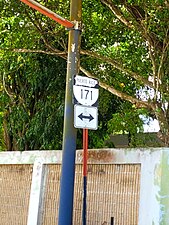 Sign for PR-171 at PR-7733 junction in Sud, Cidra
.jpg)
.jpg)
| Municipality | Location | km[1] | mi | Destinations | Notes |
|---|---|---|---|---|---|
| Cayey | Cayey barrio-pueblo | 8.3 | 5.2 | Southern terminus of PR-171 | |
| Rincón | 6.1 | 3.8 | |||
| Cidra | Rincón | 5.4 | 3.4 | ||
| 4.6 | 2.9 | ||||
| 4.2– 4.1 | 2.6– 2.5 | ||||
| Sud | 0.6 | 0.37 | |||
| Cidra barrio-pueblo | 0.0 | 0.0 | Northern terminus of PR-171 | ||
| 1.000 mi = 1.609 km; 1.000 km = 0.621 mi | |||||
See also[edit]
References[edit]
- ^ a b Google (2 March 2020). "PR-171" (Map). Google Maps. Google. Retrieved 2 March 2020.
- ^ "Cayey, Memoria Núm. 42" (PDF). Puerto Rico Planning Board (in Spanish). 1955. Retrieved 4 August 2020.
- ^ National Geographic Maps (2011). Puerto Rico (Map). 1:125,000. Adventure Map (Book 3107). Evergreen, Colorado: National Geographic Maps. ISBN 978-1566955188. OCLC 756511572.
- ^ "Tránsito Promedio Diario (AADT)". Transit Data (Datos de Transito) (in Spanish). DTOP PR. p. 90. Archived from the original on 1 April 2019.
External links[edit]
 Media related to Puerto Rico Highway 171 at Wikimedia Commons
This Puerto Rico road-related article is a stub. You can help Wikipedia by expanding it. |