
Puerto Rico Highway 735
Highway 735 | ||||
|---|---|---|---|---|
| Ruta 735 | ||||
| Route information | ||||
| Maintained by Puerto Rico DTPW | ||||
| Length | 2.7 km[1] (1.7 mi) | |||
| Existed | 1953[2]–present | |||
| Major junctions | ||||
| South end | ||||
| North end | ||||
| Location | ||||
| Country | United States | |||
| Territory | Puerto Rico | |||
| Municipalities | Cayey, Cidra | |||
| Highway system | ||||
| ||||


Puerto Rico Highway 735 (PR-735) is a rural road located between the municipalities of Cayey and Cidra, Puerto Rico,[3][4] and it corresponds to an original segment of the historic Carretera Central.[2] The Arenas and La Liendre old bridges are located on this route.[5][6]
-
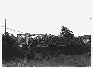 Arenas Bridge
 -
 La Liendre Bridge


Major intersections[edit]
| Municipality | Location | km[1] | mi | Destinations | Notes |
|---|---|---|---|---|---|
| Cayey | Monte Llano–Cayey barrio-pueblo line | 2.7 | 1.7 | Seagull intersection; southern terminus of PR-735; the Carretera Central continues toward Cayey; access to Caguas and Salinas | |
| Monte Llano–Cayey barrio-pueblo– Rincón tripoint | 2.4 | 1.5 | PR-738 | Northern terminus of PR-738; access to PR-1 and Cedro; unsigned | |
| Río de la Plata | 1.6– 1.5 | 0.99– 0.93 | Puente Arenas[7] | ||
| Cidra | Arenas | 1.2 | 0.75 | Southern terminus of PR-734; cardinal direction changes from north–south to east–west | |
| Quebrada Beatriz | 0.7 | 0.43 | Puente La Liendre[7] | ||
| Cayey | Vegas | 0.0 | 0.0 | Northern terminus of PR-735; the Carretera Central continues toward Caguas; access to Cayey and Salinas | |
| 1.000 mi = 1.609 km; 1.000 km = 0.621 mi | |||||
See also[edit]
References[edit]
- ^ a b Google (29 February 2020). "PR-735" (Map). Google Maps. Google. Retrieved 29 February 2020.
- ^ a b "Cayey, Memoria Núm. 42" (PDF). Puerto Rico Planning Board (in Spanish). 1955. Retrieved 23 May 2019.
- ^ National Geographic Maps (2011). Puerto Rico (Map). 1:125,000. Adventure Map (Book 3107). Evergreen, Colorado: National Geographic Maps. ISBN 978-1566955188. OCLC 756511572.
- ^ "Tránsito Promedio Diario (AADT)". Puerto Rico Department of Transportation and Public Works (in Spanish). p. 127. Archived from the original on 1 April 2019. Retrieved 23 May 2019.
- ^ "Historic Places in Puerto Rico and the Virgin Islands: A Travel Itinerary: Arenas Bridge". National Park Service. Retrieved 23 May 2019.
- ^ Luis Pumarada O'Neill (31 July 1994). "National Register of Historic Places Registration: La Liendre Bridge / Bridge #467". National Park Service. Retrieved 23 May 2019. With accompanying two photos from 1989 and 1993
- ^ a b Luis F. Pumarada O’Neill (1991). "Los Puentes Históricos de Puerto Rico" (PDF) (in Spanish). Retrieved 10 March 2020.
External links[edit]
 Media related to Puerto Rico Highway 735 at Wikimedia Commons
This Puerto Rico road-related article is a stub. You can help Wikipedia by expanding it. |