
Punchbowl Formation
| Punchbowl Formation | |
|---|---|
| Stratigraphic range: Mid-Late Miocene (Clarendonian-Hemphillian) ~ | |
 Outcrop of the tilted formation at the eponymous Devil's Punchbowl | |
| Type | Formation |
| Underlies | Crowder Formation[1] |
| Overlies | Paradise Springs Formation |
| Lithology | |
| Primary | Conglomerate, sandstone |
| Other | Mudstone |
| Location | |
| Coordinates | 34°00′N 118°12′W / 34.0°N 118.2°W |
| Approximate paleocoordinates | 33°24′N 114°24′W / 33.4°N 114.4°W |
| Region | Los Angeles County, California |
| Country | |
| Extent | San Gabriel Mountains |
| Type section | |
| Named for | Devil's Punchbowl |
| Named by | Noble |
| Year defined | 1953 |
 Punchbowl Formation (the United States)  Punchbowl Formation (California) | |
The Punchbowl Formation is a sedimentary sandstone geologic formation in the northern San Gabriel Mountains, above the Antelope Valley in Los Angeles County, southern California.[2][3]
Geology[edit]
The sandstone beds of the formation are exposed in the walls of the Devil's Punchbowl, a scenic gorge within the Devil's Punchbowl Natural Area, an L.A. County park within the Angeles National Forest. Three separate faults have folded and uplifted the formation in view.[2] The Devil's Punchbowl is a large plunging sandstone syncline, where the edges of the formation have been folded upward, and the center has dipped. It was formed by the Punchbowl Fault, which is near the San Andreas Fault to the north.
The Punchbowl Formation crops out in the Punchbowl Block and comprises approximately 1,500 metres (4,900 ft) of fluvial and alluvial conglomerates, sandstones, and minor mudstones, which accumulated during the middle-late Miocene. A distinct basal member is middle Miocene in age. The underlying Paradise Springs and Vasquez Formations were formerly interpreted as either part of the basal Punchbowl Formation, or deposits in a fault-bounded sliver along the Punchbowl Fault that originated in a separate basin.[4]
The Devil's Punchbowl drainage flows into Sandrock Creek, a tributary of Big Rock Creek, which disappears into the Mojave Desert.[2]
Fossil content[edit]
The uplifted formation preserves fossils dating back to the Neogene period of the Cenozoic geologic era,[3] formed during the lower Pliocene to upper Miocene Ages (~5-10 million years ago).[2][5]
Mammals[edit]
Artiodactyls[edit]
Perissodactyls[edit]
Carnivora[edit]
Rodents[edit]
Reptiles[edit]
Turtles[edit]
Gallery[edit]
-

-
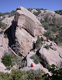 Formation at Devil's Punchbowl
 -
 Formation in the Angeles National Forest
 -
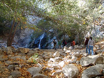 Formation at Sturtevant Falls


.jpg)
.jpg)
See also[edit]
References[edit]
- ^ Thomas W. Dibblee (1967). "Areal geology of the western Mojave Desert, California" (PDF). Geological Survey Professional Paper. 522: 49. doi:10.3133/PP522. ISSN 0096-0446. Wikidata Q57842316.
- ^ a b c d UCB−Seismo.berkeley.edu: Field Guide to the Punchbowl Fault Zone at the Devil's Punchbowl Natural Area Archived 2016-03-05 at the Wayback Machine . accessed 7.7.2015
- ^ a b Punchbowl Formation at Fossilworks.org
- ^ Coffey et al., 2019, p.480
- ^ L.A. County: "Geological History", with images
- ^ a b c d Pagnac, 2006
- ^ Liter & Prothero, 2003
- ^ a b c d e f g h i j k l m n o p q r s Woodburne & Golz, 1972
- ^ a b c Wagner & Reynolds, 1983
- ^ Woodburne, 2005
Bibliography[edit]
- Coffey, Kevin T.; Raymond V. Ingersoll, and Axel K. Schmitt. 2019. Stratigraphy, provenance, and tectonic significance of the Punchbowl block, San Gabriel Mountains, California, USA. Geosphere 15. 479–501. .
- Pagnac, D. 2006. Scaphohippus, a new genus of horse (Mammalia: Equidae) from the Barstow Formation of California. Journal of Mammalian Evolution 13. 37–61. .
- Woodburne, M. O. 2005. A new occurrence of Cormohipparion, with implications for the Old World Hippotherium Datum. Journal of Vertebrate Paleontology 25. 256–257. .
- Liter, M., and D. Prothero. 2003. New dromomerycids (Mammalia: Artiodactyla) from the middle Miocene Sharktooth Hill Bonebed, California, and the systematics of the cranioceratinins. Journal of Vertebrate Paleontology 23. 72A. .
- Wagner, H. M., and R. E. Reynolds. 1983. Leptarctus ancipidens (White) (Carnivora: Mammalia) from the Punchbowl Formation, Cajon Pass, California. Bulletin of the Southern California Academy of Sciences 82. 131–137. .
- Woodburne, M. O., and D. J. Golz. 1972. Stratigraphy of the Punchbowl Formation, Cajon Valley, southern California. University of California Publications in Geological Sciences 92. 1–72. .
External links[edit]
- Geologic formations of California
- Miocene Series of North America
- Miocene California
- Langhian
- Serravallian
- Tortonian
- Clarendonian
- Hemphillian
- Conglomerate formations
- Sandstone formations of the United States
- Alluvial deposits
- Fluvial deposits
- Paleontology in California
- Geology of Los Angeles County, California
- San Gabriel Mountains
- Angeles National Forest