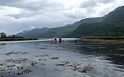
River Ruel
| River Ruel | |
|---|---|
 The river's outflow at Loch Ruel, looking south | |
| Physical characteristics | |
| Source | |
| • location | Cowal |
| • coordinates | 56°05′27″N 5°04′42″W / 56.09090800°N 5.078364971°W |
| Mouth | Loch Ruel |
• location | Cowal |
• coordinates | 55°57′48″N 5°11′26″W / 55.96331773°N 5.19057047°W |
River Ruel is a watercourse in Argyll and Bute, Scotland.[1][2] Around 9 miles (14 km) long, it flows into Loch Ruel (also known as Loch Riddon).[1]
The river passes settlements such as Clachan of Glendaruel and Ormsdale.[1]
References[edit]
- ^ a b c "River Ruel from The Gazetteer for Scotland". www.scottish-places.info. Retrieved 12 July 2023.
- ^ Congress, Library of (2007). Library of Congress Subject Headings. Library of Congress.
