
Roche de Smet
| Roche de Smet | |
|---|---|
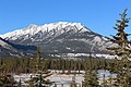
 Roche De Smet seen from Highway 16 | |
| Highest point | |
| Elevation | 2,539 m (8,330 ft)[1][2][3] |
| Prominence | 847 m (2,779 ft)[3] |
| Parent peak | Redan Mountain[3] |
| Listing | Mountains of Alberta |
| Coordinates | 53°08′03″N 118°06′59″W / 53.13417°N 118.11639°W[4] |
| Geography | |
 Roche de Smet Location of Roche de Smet in Alberta  Roche de Smet Roche de Smet (Canada) | |
| Country | Canada |
| Province | Alberta |
| Parent range | De Smet Range Canadian Rockies |
| Topo map | NTS 83E1 Snaring River[4] |
Roche de Smet is a 2,539 m (8,330 ft) mountain summit located in the Athabasca River valley of Jasper National Park in Alberta, Canada. It is situated in the De Smet Range of the Canadian Rockies. It was named in 1896 after Pierre-Jean De Smet.[1][3]
Climate[edit]
Based on the Köppen climate classification, Roche de Smet is located in a subarctic climate with cold, snowy winters, and mild summers.[5] Temperatures can drop below -20 °C with wind chill factors below -30 °C. Precipitation runoff from Roche de Smet drains into tributaries of the Athabasca River.
See also[edit]
References[edit]
- ^ a b "Roche Pierre-Jean De Smet". cdnrockiesdatabases.ca. Retrieved 2019-04-05.
- ^ "Topographic map of Roche de Smet". opentopomap.org. Retrieved 2022-09-18.
- ^ a b c d "Roche De Smet". Bivouac.com. Retrieved 2019-04-05.
- ^ a b "Roche de Smet". Geographical Names Data Base. Natural Resources Canada. Retrieved 2021-02-05.
- ^ Peel, M. C.; Finlayson, B. L. & McMahon, T. A. (2007). "Updated world map of the Köppen−Geiger climate classification". Hydrol. Earth Syst. Sci. 11: 1633–1644. ISSN 1027-5606.
Gallery[edit]
-
 Roche de Smet from the south
 -
 Roche de Smet in upper right
 -
 Northeast aspect of Roche de Smet
.jpg)


This Alberta location article is a stub. You can help Wikipedia by expanding it. |