
Shanty Town, Minnesota
Shanty Town | |
|---|---|
 Shanty Town Location of Shanty Town within Salem Township, Olmsted County  Shanty Town Shanty Town (the United States) | |
| Coordinates: 43°58′27″N 92°38′24″W / 43.97417°N 92.64000°W | |
| Country | United States |
| State | Minnesota |
| County | Olmsted |
| Township | Salem Township |
| Elevation | 1,125 ft (343 m) |
| Time zone | UTC-6 (Central (CST)) |
| • Summer (DST) | UTC-5 (CDT) |
| ZIP code | 55920 |
| Area code | 507 |
| GNIS feature ID | 654936[1] |
Shanty Town is an unincorporated community in Salem Township, Olmsted County, Minnesota, United States, near Byron. The community is located along Olmsted County Road 150 near 35th Street SW.
References[edit]
Municipalities and communities of Olmsted County, Minnesota, United States | ||
|---|---|---|
| Cities | 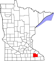 | |
| Townships | ||
| CDPs | ||
| Unincorporated communities | ||
| Footnotes | ‡This populated place also has portions in an adjacent county or counties | |