
Sierra Buttes
| Sierra Buttes | |
|---|---|
 Northeast aspect. Lookout visible at summit. | |
| Highest point | |
| Elevation | 8,591 ft (2,619 m)[1][2] |
| Prominence | 1,870 ft (570 m)[3] |
| Parent peak | Peak 8740[4] |
| Isolation | 17.81 mi (28.66 km)[4] |
| Listing | Sierra Peaks Section |
| Coordinates | 39°35′37″N 120°38′49″W / 39.5935382°N 120.6470451°W[5] |
| Geography | |
 Sierra Buttes Location in California  Sierra Buttes Sierra Buttes (the United States) | |
| Location | Sierra County, California, U.S. |
| Parent range | Sierra Nevada[3] |
| Topo map | USGS Sierra City |
| Geology | |
| Age of rock | Devonian |
| Type of rock | Metavolcanic rock |
| Climbing | |
| Easiest route | Hiking trail + stairs |
Sierra Buttes is an 8,591-foot-elevation (2,619-meter) mountain summit located in the Sierra Nevada mountain range in Sierra County, California, United States.[5] It is the third-highest point in Sierra County following the north ridge of Mount Lola and Peak 8740. Sierra Buttes are set on land managed by Tahoe National Forest and are within the North Yuba River watershed. The summit is situated two miles (3.2 km) north of Sierra City, and approximately 70 miles (110 km) northeast of Sacramento. Topographic relief is significant as the southwest aspect rises nearly 4,700 feet (1,400 meters) above the Yuba–Donner Scenic Byway in approximately two miles. The prominent fortress-like landform is visible from as far as the Sacramento Valley,[6] and inclusion on the Sierra Peaks Section peakbagging list generates climbing interest. This landform's toponym has been officially adopted by the U.S. Board on Geographic Names,[5] and has been in use since at least 1896 when published by the Sierra Club.[7]
Lookout[edit]
A fire lookout tower that was originally built in 1915 tops the highest point on Sierra Buttes. In 1964, employees of the National Forest Service erected metal stairs with railings for the public to safely access the views from the lookout. The hike to the lookout is one of the most popular destinations in the northern Sierra region.[8] The Sierra Buttes trail is 2.3 miles long, gains 1,587 feet of elevation, and one mile of it is shared with the Pacific Crest Trail.[9] In good weather, Lassen Peak can be seen from the lookout, 65 miles to the northwest, as well as Mount Shasta 150 miles distant. Sierra Valley can be seen to the east.
Climate[edit]
According to the Köppen climate classification system, Sierra Buttes is located in an alpine climate zone.[10] Most weather fronts originate in the Pacific Ocean and travel east toward the Sierra Nevada mountains. As fronts approach, they are forced upward by the peaks (orographic lift), causing them to drop their moisture in the form of rain or snowfall onto the range.
Geology[edit]
The Sierra Buttes are composed of metavolcanic rock, predominantly andesitic hydroclastic breccia and peperite which intruded the Sierra Buttes Formation.[11] The rock is part of the Northern Sierra Terrane and was formed in an undersea volcanic process along an island arc during the late Devonian period. Gold nuggets were discovered at mines surrounding the Sierra Buttes during the California Gold Rush, the largest of which weighed 106 pounds was uncovered in 1869.[12]
Gallery[edit]
-
 Sierra Buttes' fire lookout and metal stairs
 -
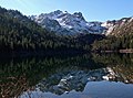
 Sierra Buttes reflected in Sardine Lake at sunrise
 -
 Sierra Buttes in late November
 -
 South aspect from Sierra City
 -
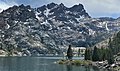 Upper Sardine Lake and Sierra Buttes
 -
 North aspect of Sierra Buttes seen from Gold Lake Highway
 -
-

-
 Looking down the stairs of Sierra Buttes


See also[edit]
References[edit]
- ^ Cheryl Angelina Koehler (2007), Touring the Sierra Nevada, University of Nevada Press, ISBN 9780874177176
- ^ United States Geological Survey topographical map - Sierra City
- ^ a b "Sierra Buttes, California". Peakbagger.com. Retrieved 2022-06-28.
- ^ a b "Sierra Buttes, North - 8,591' CA". listsofjohn.com. Retrieved 2022-06-28.
- ^ a b c "Sierra Buttes". Geographic Names Information System. United States Geological Survey, United States Department of the Interior. Retrieved 2022-06-28.
- ^ John Elliott (2021), On the Trail: Sacramento Valley and Surrounding Mountains, Page Publishing, ISBN 9781684568673
- ^ Sierra Club Bulletin, Volume 1, 1896, p. 13
- ^ Peter Massey, Jeanne Wilson, Angela Titus (2006), California Trails Northern Sierra Region, Adler Publishing Company, ISBN 9781930193239, p. 193
- ^ Matt Johanson (2019), Sierra Summits: A Guide to Fifty Peak Experiences in California's Range of Light, Falcon Guides, ISBN 9781493036455, p. 25
- ^ "Climate of the Sierra Nevada". Encyclopædia Britannica.
- ^ David R. Lageson, Mary M. Lahren, Stephen George Peters (2000), Great Basin and Sierra Nevada, Geological Society of America, p. 274
- ^ Monumental Nugget, Sierra County Historical Society
External links[edit]
- Weather forecast: Sierra Buttes
- Sierra Buttes trail: Hikingproject.com
- 2022 fatality: sfgate.com