
Star Junction Historic District
Star Junction Historic District | |
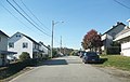
 Old company store in Star Junction, May 1989 | |
  | |
| Location | Roughly the jct. of PA 51 and PA 4036, including Post Office Rd., Church St., PA 532, and Old Ridge Rd., Perry Township, Pennsylvania |
|---|---|
| Coordinates | 40°03′42″N 79°45′43″W / 40.06167°N 79.76194°W |
| Area | 100 acres (40 ha) |
| Built | 1892 |
| Built by | Washington Coal and Coke |
| Architectural style | company built miner's duplex |
| MPS | Bituminous Coal and Coke Resources of Pennsylvania MPS |
| NRHP reference No. | 97001244[1] |
| Added to NRHP | October 24, 1997 |
The Star Junction Historic District is a national historic district that is located in Perry Township, Fayette County, Pennsylvania.
It was added to the National Register of Historic Places in 1997.[1]
History and architectural features[edit]
This district includes 163 contributing buildings and two contributing structures that are located in the bituminous coal mining community of Star Junction. Most of the contributing buildings were built between 1892 and 1918; 130 are two-story, frame duplex workers' houses. The oldest building is the Whitsett farmhouse; it was built circa 1845. Other buildings and structures include twenty-two mine managers' dwellings ("Tony Row"), two former mine buildings, two churches, a parsonage, two commercial buildings, a concrete highway bridge (1921), and n earthen dam reservoir (c. 1892).[2]
It was added to the National Register of Historic Places in 1997.[1]
Gallery[edit]
-
 A string of Star Junction company homes, October 2009
 -
 Star Junction coal-patch style housing, October 2009


References[edit]
- ^ a b c "National Register Information System". National Register of Historic Places. National Park Service. July 9, 2010.
- ^ "National Historic Landmarks & National Register of Historic Places in Pennsylvania" (Searchable database). CRGIS: Cultural Resources Geographic Information System. Note: This includes Clinton E. Piper (July 1997). "National Register of Historic Places Inventory Nomination Form: Star Junction Historic District" (PDF). Retrieved January 29, 2012.
External links[edit]
- Town of Star Junction, State Route 51, Star Junction, Fayette County, PA: 7 photos, 34 data pages, and 1 photo caption page at Historic American Buildings Survey
- Town of Star Junction, State Route 51, Star Junction, Fayette County, PA: 1 photo and 1 photo caption page at Historic American Buildings Survey
