
Stillwater Covered Bridge No. 134
Stillwater Covered Bridge No. 134 | |
 Stillwater Covered Bridge, May 2009 | |
  | |
| Location | Pennsylvania Route 629, Stillwater, Pennsylvania |
|---|---|
| Coordinates | 41°9′7″N 76°21′39″W / 41.15194°N 76.36083°W |
| Area | 0.1 acres (0.040 ha) |
| Built | 1849 |
| Built by | James McHenry, John Edson |
| Architectural style | Burr Truss Arch |
| MPS | Covered Bridges of Columbia and Montour Counties TR |
| NRHP reference No. | 79003177[1] |
| Added to NRHP | November 29, 1979 |
The Stillwater Covered Bridge No. 134 is a historic wooden covered bridge located at Stillwater in Columbia County, Pennsylvania. It is a 151-foot-long (46 m), Burr Truss arch bridge with a galvanized steel roof constructed in 1849. It crosses the Big Fishing Creek. It is one of 28 historic covered bridges in Columbia and Montour Counties.[2]
It was listed on the National Register of Historic Places in 1979.[1]
Gallery[edit]
-
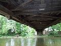 Stillwater Covered Bridge No. 134 as seen from below
 -
 Stillwater Covered Bridge No. 134 information plaque
 -
 Interior of Stillwater Covered Bridge No. 134
 -
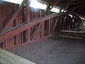 Detail of arch of Stillwater Covered Bridge No. 134
 -
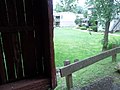 Stillwater Covered Bridge No. 134 proximity to homes
 -
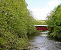 Fishing Creek with the Stillwater Covered Bridge in the background


References[edit]
Wikimedia Commons has media related to Stillwater Covered Bridge.
- ^ a b "National Register Information System". National Register of Historic Places. National Park Service. July 9, 2010.
- ^ "National Historic Landmarks & National Register of Historic Places in Pennsylvania". CRGIS: Cultural Resources Geographic Information System. Archived from the original (Searchable database) on July 21, 2007. Retrieved January 21, 2012. Note: This includes Bill Pennesi and Susan M. Zacher (n.d.). "National Register of Historic Places Inventory Nomination Form: Stillwater Covered Bridge No. 134" (PDF). Retrieved January 21, 2012.

This article about a property in Pennsylvania on the National Register of Historic Places is a stub. You can help Wikipedia by expanding it. |
This article about a bridge in Pennsylvania is a stub. You can help Wikipedia by expanding it. |
Categories:
- Covered bridges on the National Register of Historic Places in Pennsylvania
- Covered bridges in Columbia County, Pennsylvania
- Bridges completed in 1849
- Wooden bridges in Pennsylvania
- 1849 establishments in Pennsylvania
- National Register of Historic Places in Columbia County, Pennsylvania
- Road bridges on the National Register of Historic Places in Pennsylvania
- Burr Truss bridges in the United States
- Pennsylvania Registered Historic Place stubs
- Pennsylvania bridge (structure) stubs