
Stones Peak
| Stones Peak | |
|---|---|
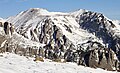
 North aspect, centered | |
| Highest point | |
| Elevation | 12,922 ft (3,939 m)[1][2] |
| Prominence | 885 ft (270 m)[3] |
| Parent peak | Mount Julian (12,933 ft)[3] |
| Isolation | 2.27 mi (3.65 km)[3] |
| Coordinates | 40°21′16″N 105°43′14″W / 40.3543079°N 105.7204233°W[4] |
| Naming | |
| Etymology | George Hapgood Stone |
| Geography | |
 Stones Peak Location in Colorado  Stones Peak Stones Peak (the United States) | |
| Country | United States |
| State | Colorado |
| County | Larimer |
| Protected area | Rocky Mountain National Park |
| Parent range | Rocky Mountains Front Range[5] |
| Topo map | USGS McHenrys Peak |
| Geology | |
| Age of rock | Paleoproterozoic[6] |
| Type of rock | Biotite schist and gneiss[6] |
| Climbing | |
| Easiest route | class 2 Southwest Ridge[7] |
Stones Peak is a 12,922-foot-elevation (3,939-meter) mountain summit located in Larimer County, Colorado.[5] It is situated in Rocky Mountain National Park, one mile east of the Continental Divide and 11.5 miles (18.5 km) west of the community of Estes Park. Stones Peak is part of the Front Range which is a subrange of the Rocky Mountains. Precipitation runoff from the mountain drains into tributaries of the Big Thompson River. Topographic relief is significant as the summit rises over 3,900 feet (1,200 meters) above the Big Thompson River in Forest Canyon in two miles. The peak is a prominent landmark viewed from Forest Canyon Overlook along the Trail Ridge Road.
History[edit]
The peak's namesake is glacial geologist George Hapgood Stone (1841–1917), a professor at Colorado College (1881–1888) who visited this area in 1886.[2] The mountain's toponym was officially adopted in 1932 by the United States Board on Geographic Names.[4]
The first documented ascent of the peak (then spelled as "Stone's Peak") was made by Frederick H. Chapin and William L. Hallett as published in Chapin's 1889 book, Mountaineering in Colorado: The Peaks about Estes Park.[8]
Climate[edit]
According to the Köppen climate classification system, Stones Peak is located in an alpine subarctic climate zone with cold, snowy winters, and cool to warm summers.[9] Due to its altitude, it receives precipitation all year, as snow in winter and as thunderstorms in summer, with a dry period in late spring. This climate supports the Sprague Glacier on the southwest aspect of Stones Peak.[10]
Gallery[edit]
-
 Southeast aspect
 -
 North aspect of Stones Peak, with Longs Peak (distant left)
 -
 East aspect of Stones Peak, from Moraine Park
 -
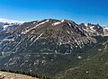 Stones Peak from Trail Ridge Road
 -
 Stones Peak (left), Hayden Spire centered, and Terra Tomah Mountain (right) viewed from Trail Ridge Road
 -
 Stones Peak centered, with Sprague Mountain and Hayden Spire to right
 -
 East aspect


See also[edit]
References[edit]
- ^ Robert M. Ormes (1992), Guide to the Colorado Mountains, Johnson Books, ISBN 9781555661946, p. 43.
- ^ a b Bright, William (2004). Colorado Place Names. Big Earth Publishing. p. 168. ISBN 978-1-55566-333-9.
- ^ a b c "Stones Peak - 12,925' CO". listsofjohn.com. Retrieved April 25, 2023.
- ^ a b "Stones Peak". Geographic Names Information System. United States Geological Survey, United States Department of the Interior. Retrieved April 25, 2023.
- ^ a b "Stones Peak, Colorado". Peakbagger.com. Retrieved April 25, 2023.
- ^ a b Geologic map of the Estes Park 30' x 60' quadrangle, north-central Colorado, W.A. Braddock, U.S. Geological Survey, 1984.
- ^ Lisa Foster, 2005, Rocky Mountain National Park: The Complete Hiking Guide, Westcliffe Publishers, ISBN 9781565795501, p. 94.
- ^ Frederick Hastings Chapin (1889), Mountaineering in Colorado: The Peaks about Estes Park, Appalachian Mountain Club, p. 147–55.
- ^ Peel, M. C.; Finlayson, B. L.; McMahon, T. A. (2007). "Updated world map of the Köppen−Geiger climate classification". Hydrol. Earth Syst. Sci. 11. ISSN 1027-5606.
- ^ James Fargo Balliett (2016), Mountains Environmental Issues, Global Perspectives, Publisher: Taylor & Francis, ISBN 9781315496993
External links[edit]
- Weather forecast: Stones Peak
Places adjacent to Stones Peak | ||||||||||||||||
|---|---|---|---|---|---|---|---|---|---|---|---|---|---|---|---|---|
| ||||||||||||||||