
Stowting
| Stowting | |
|---|---|
 St Mary's Church, Stowting | |
 Stowting Location within Kent | |
| Population | 238 (parish, 2001 Census) |
| OS grid reference | TR124417 |
| District | |
| Shire county | |
| Region | |
| Country | England |
| Sovereign state | United Kingdom |
| Post town | Ashford |
| Postcode district | TN25 |
| Police | Kent |
| Fire | Kent |
| Ambulance | South East Coast |
Stowting is a village and civil parish in the English county of Kent. It is 6 miles (9.7 km) east of Ashford, 7 miles (11 km) north-west of Folkestone and 10 miles (16 km) south of Canterbury.
History[edit]
The place name Stowting is Anglo-Saxon, meaning a 'place characterized by a mound.'[1] It was known in the time of the Domesday Book as Stotinges and Estotinges, and in later records it was called Stutinges and Stowling.[2]
The Manor of Stowting was given by Egelric Bigge, to Christ Church, in Canterbury in the year 1044. The parish church is 13th century with many later additions and alterations. It is dedicated to St Mary and is built from flint with stone dressings with a flint tower.[2] It is a Grade II listed building.[3] To the west of the church are the remains of a castle mound which are considered to be a particularly fine example of a Norman Motte-and-bailey castle.[4] In 1947, a Douglas C-47A crashed on the hillside above the village, killing eight of the 16 people on board.[5][6]
The modern village[edit]
The scattered village stands at the southern foot of a chalk hill, part of the North Downs and is located beside a chalk spring. To the north of the village centre the hamlets of Stowting Common and Lymbridge Green are both part of the parish. The Roman Road of Stone Street runs 1 mile (1.6 km) to the east of the village whilst the Pilgrim's Way and North Downs Way footpath runs through the village itself.[2]
Stowting has a Church of England primary school adjacent to the church. It has one pub, currently named The Tiger Inn, which dates to the 1600s and that displays a Mackesons Hythe Ales front fascia sign, depicting its earlier brewery ownership. Stowting Cricket Club was established in 1895 and plays at Dawes Field near the school and church.
Photo gallery[edit]
-
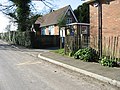 Stowting, old school building.
 -
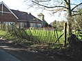 Stowting, new school building with church tower beyond.
 -
 Stowting hill, looking north west.
 -
 Stowting Hill, looking north east.
 -
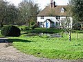 Stowting, cottage.
 -
 Old school building entrance.


References[edit]
- ^ British Marine Life Study Society. "The suffix -ing". www.glaucus.org.uk. Retrieved 25 April 2017.
- ^ a b c "Parishes: Stowting | British History Online". www.british-history.ac.uk. Retrieved 21 April 2017.
- ^ Stuff, Good. "Church of St Mary, Stowting, Kent". www.britishlistedbuildings.co.uk. Retrieved 21 April 2017.
- ^ Historic England. "Motte and Bailey Castle 200m North-West of Stowting Church (1012099)". National Heritage List for England. Retrieved 21 April 2017.
- ^ "Kent Accident Inquiry (Hansard, 29 January 1947)". Parliamentary Debates (Hansard). 29 January 1947. Retrieved 22 April 2017.
- ^ "Stowting Dakota Crash Report Western Morning News -". Sussex History Forum quoting Western Morning News. 7 May 1947.
External links[edit]
![]() Media related to Stowting at Wikimedia Commons
Media related to Stowting at Wikimedia Commons
This Kent location article is a stub. You can help Wikipedia by expanding it. |