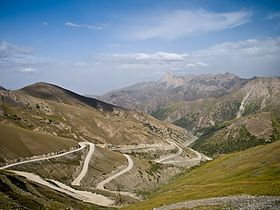
Taldyk Pass
| Taldyk Pass | |
|---|---|
| Талдык ашуусу | |
 View from Taldyk Pass to the north | |
| Elevation | 3,615 m (11,860 ft)[1] |
| Traversed by | ЭМ-05 , M41 , E007 |
| Location | Kyrgyzstan |
| Range | Alay Mountains |
| Coordinates | 39°45′54″N 73°10′06″E / 39.76512°N 73.168338°E |

Taldyk Pass is an all year round pass in the Alay Mountains of Osh Region of Kyrgyzstan. The elevation of the pass is 3,615 metres (11,860 ft). The pass is traversed by European route E007, route M41,[1] and ЭМ-05 Road: Osh - Taldyk Pass - Sary-Tash.
History[edit]
The first cart road through the pass was constructed as early as in 1876. It served as a communication way to Alay Valley for a military detachment headed by the Russian general Abramov. However, in the records of expedition through Pamir route in 1883 Captain Putyata indicates that the road can not be used for this purpose anymore due to road blockage by rockfalls in some locations.[2] The cart road was reconstructed in 1893 by Colonel of the Imperial Russian Army Bronislav Grombchevsky.[3] It is reported that there was a commemorative sign with the inscription: "Taldyk pass...88 verst from Gulcha" at the pass during travels to Alay of Nikolai Korzhenevskiy, a Russian Empire and Soviet geographer and explorer, in 1903 and later. [4]
The paved road from Osh to Khorugh (eastern Tajikistan) was built through the pass in 1930–1932. Presently there is a monument to the memory of the construction manager Yuri M.Grushko at the pass.[1]
In December 2008 Export–Import Bank of China provided $75.29 million in loan and US$7.5 million in grant for rehabilitation of the road segment crossing Taldyk Pass (km 123 -190). The project was completed in December 2013 [5] [6]
References[edit]
- ^ a b c Ошская область:Энциклопедия [Encyclopedia of Osh Oblast] (in Russian). Bishkek: Chief Editorial Board of Kyrgyz Soviet Encyclopedia. 1987. p. 445.
- ^ Captain Putyata (1884). Очерк экспедиции Генерального штаба капитана Путята в Памир, Сарыкол, Вахан и Шугнан 1883 г [Records of Expedition of the General Staff by Captain Putyata to Pamir, Sarykol, Vakhan and Shugnan in 1883] (Report). Military Science Committee of the General Staff. Retrieved 2023-09-24.
- ^ M. G. Gerard (1897). Report on the Proceedings of the Pamir Boundary Commission (Report). Office of the Superintendant of Government Printing, India. p. 5. Retrieved 2023-09-24.
- ^ "VIVOS VOCO: П.Ф. Пэтэрс, ПАМИРСКИЕ ПУТЕШЕСТВИЯ НИКОЛАЯ КОРЖЕНЕВСКОГО" [Pamir Travels of Nikolai Korzhenevskiy]. vivovoco.astronet.ru. Archived from the original on 2015-04-09. Retrieved 2023-09-24.
- ^ "China Eximbank provides $75.29 million preferential buyer's credit for the Osh-Sarytash-Irkeshtam Road Rehabilitation Project". AidData. William & Mary's Global Research Institute. Retrieved 2023-09-25.
- ^ "Chinese government provides a $7.5 million grant for the Osh-Sarytash-Irkeshtam Road Rehabilitation Project". AidData. William & Mary's Global Research Institute. Retrieved 2023-09-25.

