Talk:Geo URI scheme
| This article is rated C-class on Wikipedia's content assessment scale. It is of interest to the following WikiProjects: | ||||||||||||||||||
| ||||||||||||||||||
About the order of "crs" and "u"[edit]
The Section "Coordinate reference system" says
   geo:37.786971,-122.399677;u=35;crs=Moon-2011

 The order in which the semicolon-separated parameters occur
 is not significant, [1] and 'crs' parameter values are
 case-insensitive, [1] so the above example is exactly equivalent to:

   geo:37.786971,-122.399677;crs=moon-2011;u=35
Actually, [1] (more precisely, RFC 5870, Section 3.3, page 7) says that
The 'crs' parameter MUST be given first if both 'crs' and 'u' are used.
Therefore, it seems that example given is not compliant with RFC 5870. Am I right?
Fintatarta (talk) 12:01, 25 May 2011 (UTC)
Insert a working example?[edit]
Currently, the page contains the readable form of code that would create a Hyperlink to a Geo URI. But it would be even nicer to have a real, working example, that is, a link to a Geo URI that can actually be clicked. It's rather hard to find websites with that kind of link, so it seems reasonable to at least have one here so that people can test how their browser reacts to it. Unfortunately, I was not able to edit the page that way. If someone knows the wiki markup to create a link to an URI that's not http / https this would be nice. --DieLenaMaria (talk) 20:40, 19 March 2012 (UTC)
External links modified[edit]
Hello fellow Wikipedians,
I have just modified one external link on Geo URI scheme. Please take a moment to review my edit. If you have any questions, or need the bot to ignore the links, or the page altogether, please visit this simple FaQ for additional information. I made the following changes:
- Added archive https://web.archive.org/web/20111227152230/http://geourl.org:80/ to http://geourl.org/
When you have finished reviewing my changes, you may follow the instructions on the template below to fix any issues with the URLs.
This message was posted before February 2018. After February 2018, "External links modified" talk page sections are no longer generated or monitored by InternetArchiveBot. No special action is required regarding these talk page notices, other than regular verification using the archive tool instructions below. Editors have permission to delete these "External links modified" talk page sections if they want to de-clutter talk pages, but see the RfC before doing mass systematic removals. This message is updated dynamically through the template {{source check}} (last update: 18 January 2022).
- If you have discovered URLs which were erroneously considered dead by the bot, you can report them with this tool.
- If you found an error with any archives or the URLs themselves, you can fix them with this tool.
Cheers.—InternetArchiveBot (Report bug) 09:43, 9 January 2017 (UTC)
The semantic of elevation and fig[edit]
Section 3.4.5 explains that "... undefined <altitude> MAY assume that the URI refers to the respective location on Earth's physical surface ..." and that "... altitudes are relative to the WGS-84 reference geoid rather than Earth's surface. Hence, an <altitude> value of 0 MUST NOT be mistaken to refer to 'ground elevation'".
Important considerations, but seems confuse to express in an encyclopedic article... Ideal is to add the information with some illustration.
The "ground elevation" (referred by RFC 5870) at the latitude-longitude point is h, synonym of "projection in the Terrain surface"; and the "altitude=0" is the projection on the surface of the ellipsoid (not N nor WD=0).
Semantic of uncertainty and interpretaton[edit]

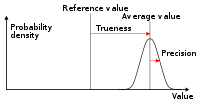
The RFC 5870 not formalize the uncertainty, and obligate the use of units that, in general and in default, is not the unit of the coordinates (CRS). The clues about it comes from citations: the only normative reference with something about uncertainty is the [RFC 5491] (see its section 5); and informative reference say less [ISO.6709.2008] (not use "uncertainty" but use the terms "accuracy" and "precision" that perhaps are the same as ISO 5725-1 illustrated), [RFC3693] and [WGS84].
A personal interpretation of the RFC[edit]
Geo URI is not about exact abstract positions, strictly it is an Location Estimate, and we can interpretate it (from RFC5870 and RFC5491) as the approximate physical position of an object in the Earth's surface.
...


