
Talk:Gospel Oak to Barking line
| This article is rated C-class on Wikipedia's content assessment scale. It is of interest to the following WikiProjects: | ||||||||||||||||||||||||||||||||||||
| ||||||||||||||||||||||||||||||||||||


| The route diagram template for this article can be found in Template:Gospel Oak to Barking Line. |
| On 15 February 2024, it was proposed that this article be moved to Suffragette line. The result of the discussion was not moved. |
Should the map show historic parts of the line?[edit]
I was wondering whether the map should show stations like Kentish Town and East Ham, which are no longer connected to the line? Do we regard these as relevant to the article? There are separate articles for the Tottenham & Hampstead Junction Railway and Tottenham & Forest Gate Railway which already cover these historic branches. --DanielRigal 12:53, 11 May 2007 (UTC)
- I suggest that a separate article should cover the closed stations. If you take a look at Disused railway stations (Exeter to Plymouth Line) and Disused railway stations (Bristol to Exeter Line), for example, you'll see the approach that Geof Sheppard is taking with regard to the West of England GWR lines, which seems to be developing nicely. -- EdJogg 23:22, 11 May 2007 (UTC)
- The link to the Midland Main Line helps a bit ... except that it does not show Kentish Town. I guess we need a link to Thameslink ... but I can see that going down like a lead balloon. Canterberry 12:53, 12 May 2007 (UTC)
Forest Gate/Wanstead Park interchange[edit]
Please see Talk:Forest Gate railway station#Official interchange for a query about differences between articles. Timrollpickering 09:32, 20 June 2007 (UTC)
Diagram modification[edit]
Currently the diagram shows the option for GOBLIN trains to run on beyond Gospel Oak to the North London Line. This is slightly inaccuarate - the platform arrangement at Gospel Oak is such that the GOBLIN terminates in a bay with no possibility for onward running. The through line doesn't have a platform at Gospel Oak (which will be a major problem if and when the line is better integrated into the wider network).
Is anyone skilled enough to modify the diagram to show this? The North London Line diagram handles this better. Timrollpickering 14:42, 27 July 2007 (UTC)
- I have modified the diagram to reflect this although I had to do it in a much simpler way than the NLL diagram as I find the diagrams far from easy to manipulate. --DanielRigal 19:49, 28 July 2007 (UTC)
- Many thanks. Timrollpickering 19:52, 28 July 2007 (UTC)
St Ann's Road[edit]
Shouldn't this station be marked on the diagram? According to it's wikipedia page it was located on the old line before it was amalgamated into the GOBLIN. It closed in the Second World War, but so did Junction Road and that is marked on the map. —Preceding unsigned comment added by 86.160.195.96 (talk) 02:01, 17 March 2008 (UTC)
- If we are going to have some of them then all disused stations should be shown. My view is that the GOBLIN started in 1981 and hence the stations from before that time are not relevant. They are listed on the articles for the two predecessor lines. That said, I don't object too much if we have them listed here, so long as we have them all for consitency. At the moment East Ham is also missing. --DanielRigal (talk) 13:12, 17 March 2008 (UTC)
Current usage[edit]
Station usage figures show that the line has already seen major growth of passengers since the takeover, although this has led to some crowding issues.
There's no source for this and is there any firm evidence that usage is growing as opposed to the TfL installation of ticket machines and readers that make data collection a heck of a lot easier? Also most of the "station usage" figures floating around are actually "ticket sales allocated to the station" which can be misleading, especially in London with so many travelcards used to say nothing of the mess that are station groups. Timrollpickering (talk) 14:23, 23 June 2008 (UTC)
- I agree with your assessment. As a user of the line for several years my experience is that the usage has not risen dramatically. It was crammed to capacity before! Silverlink probably never had a clue how many customers they really had. --DanielRigal (talk) 15:51, 23 June 2008 (UTC)
Name of the line / article[edit]
Why is the article called "Gospel Oak to Barking Line"? All its antecedents were called
the place A AND place B railway, for obvious reasons and this should be the Gospel Oak AND Barking line (or Barking and Gospel Oak line). It isn't the Waterloo to City line, is it! —Preceding unsigned comment added by 206.165.217.125 (talk) 11:31, 23 July 2008 (UTC)
Article name, again[edit]
Surely shouldn't the article be called Gospel Oak-Barking Line. This avoids the confusion of whether or not it should be 'and' or 'to; also, it seems to work elsewhere (e.g. Hitchin-Cambridge Line). Kevin Steinhardt (talk) 14:04, 9 August 2008 (UTC)
diagram[edit]
I have tried to redo the diagram so that the elevated sections are shown. My attempt is at User:DanielRigal/sandbox but it isn't perfect. I had to cheat because there is no symbol for an elevated line crossing an underground one. It may also be sub-optimal in other ways. What does everybody think? Should I put it live or does it need further work? --DanielRigal (talk) 18:18, 11 October 2008 (UTC)
Connection to NLL[edit]
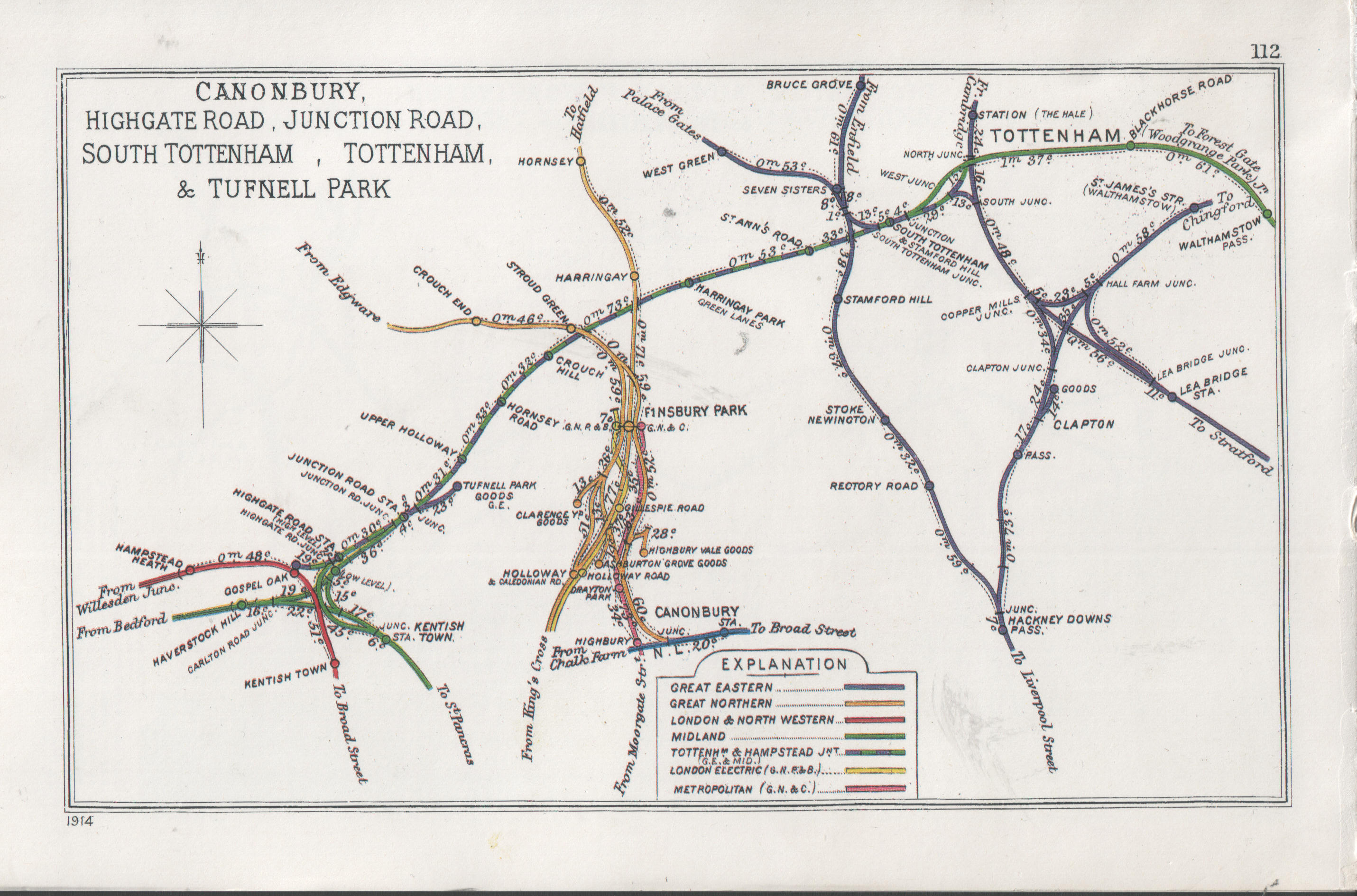
The map shows a connection near Gospel Oak to the eastbound NLL. The railway junctions map http://upload.wikimedia.org/wikipedia/commons/3/3a/Canonbury%2C_Highgate_Road%2C_Junction_Road%2C_South_Tottenham%2C_Tottenham_%26_Tufnell_Park_RJD_112.jpg does not have the link. In early days the line to Gospel Oak was specifically barred from connecting to the (westbound?) NLL. Was there a link to the eastbound NLL or could it be due to a misreading of the complexity of links and junctions in the area? I recently added the connection to the NLL map because it was on the Goblin map but now I have doubts about it.--SilasW (talk) 14:40, 2 February 2010 (UTC)
- The connection does not exist (and never did) and I have tried to amend the template, but failed, even though I was using the right icon (substituting "STRr+l" in place of "exSTRq". Must be losing my touch. Bhtpbank (talk) 12:29, 3 February 2010 (UTC)
- As the person who made that change, I do wish you'd have asked me to confirm the source before making such a categorical (and wrong) statement. Yes, the junctions map doesn't show it; it pre-dates it and was removed by that time! The connection ran along the alignment of the later cutting and the only remnant now is the construction of the bridge over the Midland line (check on google earth). I have uploaded my source map and copy it here. It is absolutely clear that the link was there, and I will re-instate it on the maps. --AlisonW (talk) 15:42, 4 February 2010 (UTC)
- The words "Who put you in charge?" spring to mind. Don't you get all high-handed with me. Your map shows nothing that can be read, and provides no evidence of the link whatsoever. As for this "I wish someone had spoken to me" attitude, that has no place on Wikipedia, so take it elsewhere. Bhtpbank (talk) 20:08, 5 February 2010 (UTC)
- Hmm! (Even double Hmm!) It seems to me that on the old map the N-S line from the eastern part of the Goblin (which is one side of the pronounced triangle of lines) joins the eastward NLL (which there runs N-S) with the junction at the point where they cross) the MML. Flipping the old map and a current one at similar scales suggests strongly that that link to the NLL (none too useful as connecting East to East) surrendered its route to the present link from the Goblin to the MML heading west.--SilasW (talk) 22:48, 5 February 2010 (UTC)
- The words "Who put you in charge?" spring to mind. Don't you get all high-handed with me. Your map shows nothing that can be read, and provides no evidence of the link whatsoever. As for this "I wish someone had spoken to me" attitude, that has no place on Wikipedia, so take it elsewhere. Bhtpbank (talk) 20:08, 5 February 2010 (UTC)
- Nobody put me "in charge" but, as with many things on WP it is common politeness to discuss an issue first rather than a pre-emptory "The connection does not exist (and never did)" sans evidence. If you cannot see that there is a clear link on that - very early - map showing the line splitting just west of where later was the Highgate Road station with one side continuing to a junction at Gospel Oak and the other dropping south to join the North London Line then you should click through to the higher resolution image. And, as I noted previously, there is still one remnant of the connection on the ground in the triangular shape of the bridge where the junction was situate. --AlisonW (talk) 21:02, 6 February 2010 (UTC)
Present connection to NLL[edit]
The original connection to Gospel Oak Station was permitted by other companies on condition that the line stopped there with no westward connection to the NLL. A 1914 RCH map shows that, as it seems does the "1930's map" at http://www.abandonedstations.org.uk/Goblin.html. When was the connection built? Was it a wartime expedient?--SilasW (talk) 20:48, 28 August 2010 (UTC)
Future of the line[edit]
I just took out this stuff because it's been sitting uncited in the article for years:
- Extension of the line eastwards from Barking to Dagenham Dock and Rainham.
- Extending the line west and southwards along the North London Line from Gospel Oak to merge with the West London Line to Clapham Junction.
- In the longer term these lines could then be further integrated with the East London Line and South London Line to form a full London orbital railway system, similar to the proposed Orbirail system.
- Reconstruction of the former Junction Road station to interchange with Tufnell Park tube station on the Northern Line
- Interchange between Walthamstow Central and Walthamstow Queens Road
- Construction of a Piccadilly Line station at Harringay Green Lanes and conversion of Manor House to a Victoria Line station.
- Extension of the line to meet Heathrow airport via the Great Western Main Line.
As a contrast to that, I've greatly expanded the coverage of the interminable history of the proposed electrification. — Scott • talk 13:12, 5 December 2012 (UTC)
As electrification is now finally on the table as of last month, the entire section about that should be reorganized to put the current state of affairs first. I'll do that sooner or later. — Scott • talk 12:00, 17 July 2013 (UTC)
Wonder if with all the current shenanigans [March 2019] some tweaks might be neccesary, if someone has accurate data and sources? Ucypanp (talk) 18:11, 10 March 2019 (UTC)
External links modified[edit]
Hello fellow Wikipedians,
I have just added archive links to one external link on Gospel Oak to Barking Line. Please take a moment to review my edit. If necessary, add {{cbignore}} after the link to keep me from modifying it. Alternatively, you can add {{nobots|deny=InternetArchiveBot}} to keep me off the page altogether. I made the following changes:
- Added archive https://web.archive.org/20070315193441/http://nationalrail.co.uk:80/system/galleries/download/mobility_maps/LondonSouthEast.pdf to http://www.nationalrail.co.uk/system/galleries/download/mobility_maps/LondonSouthEast.pdf
When you have finished reviewing my changes, please set the checked parameter below to true to let others know.
This message was posted before February 2018. After February 2018, "External links modified" talk page sections are no longer generated or monitored by InternetArchiveBot. No special action is required regarding these talk page notices, other than regular verification using the archive tool instructions below. Editors have permission to delete these "External links modified" talk page sections if they want to de-clutter talk pages, but see the RfC before doing mass systematic removals. This message is updated dynamically through the template {{source check}} (last update: 18 January 2022).
- If you have discovered URLs which were erroneously considered dead by the bot, you can report them with this tool.
- If you found an error with any archives or the URLs themselves, you can fix them with this tool.
Cheers. —cyberbot IITalk to my owner:Online 01:40, 9 September 2015 (UTC)
Requested move 7 February 2017[edit]
- The following is a closed discussion of a requested move. Please do not modify it. Subsequent comments should be made in a new section on the talk page. Editors desiring to contest the closing decision should consider a move review. No further edits should be made to this section.
The result of the move request was: page moved to Gospel Oak to Barking line. (non-admin closure) TonyBallioni (talk) 02:43, 14 February 2017 (UTC)
Gospel Oak to Barking Line → Gospel Oak to Barking line – Downcase per WP:NCCAPS; sources mostly do not cap it. Optionally, say if you prefer to use the symmetric dashed version (Gospel Oak–Barking line) rather than "to" between place names. Dicklyon (talk) 01:33, 7 February 2017 (UTC)
- Evidence in sources
Please examine the searches, see if there is a common name, whether the dashed version is preferred, and whether caps are preferred. It is my impression that there is no proper name here and that the "to" form is more common (and more logical and more consistent with other such lines). Dicklyon (talk) 01:33, 7 February 2017 (UTC)
- Support as nom – and I'd stick with "to" in this one, as it's very common in sources (though the dashed form can also be found and I have no objection to it for consistency if others prefer). Dicklyon (talk) 01:33, 7 February 2017 (UTC)
- Support "to" as a long-suffering user of the line in question - the line isn't officially named the way this article is. — Scott • talk 12:34, 7 February 2017 (UTC)
- Support. --Frankie Roberto (talk) 22:14, 8 February 2017 (UTC)
- Support as line is not a proper noun, it shouldn't be capitalised. Joseph2302 (talk) 16:14, 9 February 2017 (UTC)
- The above discussion is preserved as an archive of a requested move. Please do not modify it. Subsequent comments should be made in a new section on this talk page or in a move review. No further edits should be made to this section.
External links modified[edit]
Hello fellow Wikipedians,
I have just modified 8 external links on Gospel Oak to Barking line. Please take a moment to review my edit. If you have any questions, or need the bot to ignore the links, or the page altogether, please visit this simple FaQ for additional information. I made the following changes:
- Added archive https://web.archive.org/web/20120425180718/http://www.tfl.gov.uk/static/corporate/media/newscentre/archive/7525.html to http://www.tfl.gov.uk/static/corporate/media/newscentre/archive/7525.html
- Added archive https://web.archive.org/web/20110605052459/http://www.tfl.gov.uk/assets/downloads/gospel-oak-to-barking.pdf to http://www.tfl.gov.uk/assets/downloads/gospel-oak-to-barking.pdf
- Added archive https://web.archive.org/web/20110604225930/http://www.tfl.gov.uk/assets/downloads/corporate/5-London-Overground-Review.pdf to http://www.tfl.gov.uk/assets/downloads/corporate/5-London-Overground-Review.pdf
- Added archive https://web.archive.org/web/20110721055636/http://mqt.london.gov.uk/mqt/public/question.do?id=22780 to http://mqt.london.gov.uk/mqt/public/question.do?id=22780
- Added archive https://web.archive.org/web/20120823201521/http://mqt.london.gov.uk/mqt/public/question.do?id=40757 to http://mqt.london.gov.uk/mqt/public/question.do?id=40757
- Added archive https://web.archive.org/web/20140320095908/http://mqt.london.gov.uk/mqt/public/question.do?id=42987 to http://mqt.london.gov.uk/mqt/public/question.do?id=42987
- Added
{{dead link}}tag to http://www.barking-gospeloak.org.uk/history/20121101_e_bulletin.pdf - Added archive https://web.archive.org/web/20130630205659/http://www.london.gov.uk/media/mayor-press-releases/2013/06/mayor-secures-unprecedented-transport-settlement-for-london-to to http://www.london.gov.uk/media/mayor-press-releases/2013/06/mayor-secures-unprecedented-transport-settlement-for-london-to
- Added
{{dead link}}tag to https://www.networkrail.co.uk/publications/documents/CP5-Enhancements-Delivery-Plan-June-15.pdf - Added archive https://web.archive.org/web/20110721055709/http://mqt.london.gov.uk/mqt/public/question.do?id=22779 to http://mqt.london.gov.uk/mqt/public/question.do?id=22779
When you have finished reviewing my changes, you may follow the instructions on the template below to fix any issues with the URLs.
This message was posted before February 2018. After February 2018, "External links modified" talk page sections are no longer generated or monitored by InternetArchiveBot. No special action is required regarding these talk page notices, other than regular verification using the archive tool instructions below. Editors have permission to delete these "External links modified" talk page sections if they want to de-clutter talk pages, but see the RfC before doing mass systematic removals. This message is updated dynamically through the template {{source check}} (last update: 18 January 2022).
- If you have discovered URLs which were erroneously considered dead by the bot, you can report them with this tool.
- If you found an error with any archives or the URLs themselves, you can fix them with this tool.
Cheers.—InternetArchiveBot (Report bug) 22:50, 4 September 2017 (UTC)
Gatelines[edit]
Gatelines have recently (as at 2017) been introduced at several LO only stations on the line, including Woodgrange Park (at platfrom level) and Leytonstone High Road (at street level). I think they have probably introduced at all stations, but I haven't been to them to verify this. Maybe the entries for individual stations on the line have the answer. — Preceding unsigned comment added by 92.232.34.78 (talk) 19:51, 10 January 2018 (UTC)
Overground Ghost Trains[edit]
The Current Operations section states that LO operates three trains on a Saturday between Stratford and Seven Sisters. Whilst this is clearly possible, I can't find any evidence that this actually occurs, after checking the relevant timetable, and an in-depth search of the National Rail journey planner in both directions. I am hesitant to put a citation needed notice, as I might be being stupid, and I thought I might explain at least why I am questioning it. If someone could provide any source proving that it does, that would be great (partly to go odd ways through those junctions myself) but I quite sceptical, Battersea Park for example is in the timetables (and even on the in-coach map), however, some timetabled services are not shown to call at Bethnal Green so it's possible they express through Stratford instead? I guess? Shadowssettle(talk) 19:37, 24 July 2018 (UTC)
- There is no harm in putting a Citation Needed on anything that you tried to find a citation for and failed. Maybe somebody will come along with a citation, and the article is improved, or maybe it really is dubious info, in which case tagging it is the first step towards rooting it out. Either way, there is no downside. --DanielRigal (talk) 19:50, 24 July 2018 (UTC)
- Sure Shadowssettle(talk) 20:13, 24 July 2018 (UTC)
- From PSUL 2018:
- Seven Sisters Junction - South Tottenham West Junction and South Tottenham East Junction - Tottenham South Junction (21,22) LB01A
- Saturdays from date to be advised (diverted via Stoke Newington until further notice)):
- 2U00 0530 Liverpool Street - Enfield Town
- -mattbuck (Talk) 20:24, 24 July 2018 (UTC)
- That source disputes the fact there are three services running that route, showing only one to Enfield Town, and that it is yet to commence (or that if it has commenced, the source is unaware that it has), so should this be removed, stated that "Overground services have been routed at times" or updated with the PSUL scheduled service. Shadowssettle(talk) 20:33, 24 July 2018 (UTC)
- The code LB01A refers to this document, part of the Working Timetable. The code 2U00 is a headcode, and may be found in the "Signal ID" row of page 95 (going by the numbers on the pages) or 96 (by the numbers calculated by Adobe Reader) of that doc. --Redrose64 🌹 (talk) 22:27, 24 July 2018 (UTC)
- Thanks! This shows the service is shown going through Bethnal Green and Hackney Downs, thus it couldn't be going through Stratford. As this is Network Rail, and goes against the only source suggesting even one service via this route at present, I'm editing to get rid of these services, and putting a note in that they have been operated, feel free to change as necessary Shadowssettle(talk) 07:14, 25 July 2018 (UTC)
- The code LB01A refers to this document, part of the Working Timetable. The code 2U00 is a headcode, and may be found in the "Signal ID" row of page 95 (going by the numbers on the pages) or 96 (by the numbers calculated by Adobe Reader) of that doc. --Redrose64 🌹 (talk) 22:27, 24 July 2018 (UTC)
- That source disputes the fact there are three services running that route, showing only one to Enfield Town, and that it is yet to commence (or that if it has commenced, the source is unaware that it has), so should this be removed, stated that "Overground services have been routed at times" or updated with the PSUL scheduled service. Shadowssettle(talk) 20:33, 24 July 2018 (UTC)
- From PSUL 2018:
- Sure Shadowssettle(talk) 20:13, 24 July 2018 (UTC)
The morning through-trains from Woodgrange Park to Hampstead Heath and beyond are no more, I hear. Ucypanp (talk) 18:14, 10 March 2019 (UTC)
Electrification and longer trains[edit]
I have moved these sections from the future section into the history section, since of course they are now – at long last – history. I have also made some cosmetic changes and replaced the blurry picture of a train. StewE17 (talk) 13:18, 13 August 2019 (UTC)
Move discussion in progress[edit]
There is a move discussion in progress on Talk:Watford DC line which affects this page. Please participate on that page and not in this talk page section. Thank you. —RMCD bot 15:49, 15 February 2024 (UTC)
- C-Class London-related articles
- Low-importance London-related articles
- C-Class rail transport articles
- Low-importance rail transport articles
- C-Class UK Railways articles
- Mid-importance UK Railways articles
- C-Class London Transport articles
- Low-importance London Transport articles
- WikiProject London Transport articles
- All WikiProject Trains pages