This article is within the scope of WikiProject Africa, a collaborative effort to improve the coverage of Africa on Wikipedia. If you would like to participate, please visit the project page, where you can join the discussion and see a list of open tasks.AfricaWikipedia:WikiProject AfricaTemplate:WikiProject AfricaAfrica articles
This article is within the scope of WikiProject Former countries, a collaborative effort to improve Wikipedia's coverage of defunct states and territories (and their subdivisions). If you would like to participate, please join the project.Former countriesWikipedia:WikiProject Former countriesTemplate:WikiProject Former countriesformer country articles
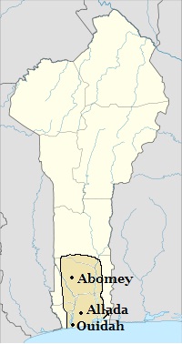
It is requested that a map or maps be included in this article to improve its quality. Wikipedians in Benin may be able to help!
Tried to construct a map of the Kingdom of Dahomey. It is available here. I think we can all agree it is pretty pitiful. Hoping someone with graphical tools that I lack could help out. This map will be displayed at Dahomey and History of the Kingdom of Dahomey pages ideally. A very simplistic map of the borders and important cities of the Kingdom would be really helpful for this page. Here is one possible source: Edna Bay Wives of the Leopard Page. 4. A better map is available Patrick Manning Slavery, Colonialism... pg. 23. There are some old maps like The Norris Map and the Guinea Propia Map by Homann but both of those seem to be of limited use. There's a few other books in libraries with ok maps if the Bay or Manning are not sufficient, and I'd be happy to provide those. Map with borders and Abomey, Allada, Whydah or Ouidah shown would be great. Current national borders, Porto Novo, Grand Popo and Oyo would all be great additions if possible. If searching for other sources: the kingdom was sometimes referred to on maps as Danhome or Fon. Any other help I can provide, please let me know and thank you in advance for any much needed graphical help. AbstractIllusions (talk) 22:48, 14 October 2012 (UTC)[reply]


