
Talk:List of rivers of England
| This article is rated List-class on Wikipedia's content assessment scale. It is of interest to the following WikiProjects: | |||||||||||||||||||||||||||||||||||||||||
| |||||||||||||||||||||||||||||||||||||||||


River Foulness[edit]
The River Foulness is missing from the list. I am unsure where to place it. It flows into the Market Weighton Canal which joins the Humber at Weighton Lock. May be it should go between Ouse & Hull
Keith D 23:32, 7 January 2007 (UTC)
Absurdity![edit]
This list is absurd in nature and contains many absurdities, since it lists so-called "rivers" that aren't rivers at all - but rather are merely brooks, streams, creeks, and so forth. At least, here in North America we understand the difference between these minor watercourses and real rivers. For example, going clockwise around the continent, the Niagara River, the St. Lawrence River, the Hudson River, the Delaware River, the Susquehanna River, the Potomac River, the Savannah River, the Chattahoochee River, the Ohio River, the Missouri River, the Mississippi River, the Colorado River, the Columbia River, the Yukon River, and so forth. To this, we will add the Thames River and the Severn River, for example.Dale101usa (talk) 15:29, 12 March 2009 (UTC)
- Also, just because a watercourse contains the words "river" or "rio" in its name does not make it an actual river. We have those in North America, too.Dale101usa (talk) 15:39, 12 March 2009 (UTC)
- From River: A river is a natural watercourse, usually freshwater, flowing toward an ocean, a lake, a sea (e.g. the Caspian Sea) or another river. ..Small rivers may also be called streams , creeks, brooks, rivulets, rills, and many other terms, but there is no general rule that defines what can be called a river. Pterre (talk) 17:22, 12 March 2009 (UTC)
- Can I suggest you look at List of rivers in Alabama (etc) for a more sensible comparison than North America? Pterre (talk) 18:42, 12 March 2009 (UTC)
- In fact this is not strictly a 'list of rivers' but a 'list of main rivers' - a term defined by the statutory body with strategic responsibility for English and Welsh watercourses, the Environment Agency and which includes this great diversity of watercourses. It might benefit from mention of that fact in the intro I guess. I began editing the Welsh rivers page a couple of years ago by deleting a very minor watercourse and was told of that, so then reinstated it. I've since added a few more minor ones. Perhaps the list can be presented in a different form which places more emphasis on the larger 'proper' rivers? The same approach would need to be adopted for other river lists, at least Scotland and Wales for consistency though. Any thoughts? Geopersona (talk) 06:25, 28 March 2010 (UTC)
- As far as I am aware this list is intended to include all rivers including some of the most minor tributaries. Perhaps though that is only tributaries on main rivers. I have been struggling to find out what the EA does define as Main rivers as this would be quite useful information but so far have been unsuccessful. If you do know the list then please add it to that article. As for this article it is getting a bit big and unwieldy but is still useful. What I find really absurd though not something worth worrying about is the List of rivers discharging into the North Sea which embraces everything from the Churn to Norwegian streams. Rgds Motmit (talk) 20:19, 28 March 2010 (UTC)
- In fact this is not strictly a 'list of rivers' but a 'list of main rivers' - a term defined by the statutory body with strategic responsibility for English and Welsh watercourses, the Environment Agency and which includes this great diversity of watercourses. It might benefit from mention of that fact in the intro I guess. I began editing the Welsh rivers page a couple of years ago by deleting a very minor watercourse and was told of that, so then reinstated it. I've since added a few more minor ones. Perhaps the list can be presented in a different form which places more emphasis on the larger 'proper' rivers? The same approach would need to be adopted for other river lists, at least Scotland and Wales for consistency though. Any thoughts? Geopersona (talk) 06:25, 28 March 2010 (UTC)
- The Environment Agency definition of a main river is quite arbitrary and can be traced back to the Rivers Conservancy Boards the predecessors of the River Boards, themselves the predecessors of the River Authorities , themselves the predecessors of (part of ) the Water Authorities who later became the National Rivers Authority and who are now the Environment Agency. What constituted a "Main River" originally was simply a definition of which river lengths that the Conservancy Boards agreed to maintain as part of their Flood defence functions. The other regulatory functions (fisheries, water quality, hydrology etc.) assumed responsibility for all rivers, main and not main. For rivers that were not "Main rivers", the relevant local authority had responsibility for flood prevention and river maintenance, a responsibility shared unequally with the riparian owner. Since the time of the Conservancy Boards, some additional rivers have been "Mained" but the status of a main river has no bearing on the size or significance of a river - it seems to depend much more on the political strength of the local farming community as the original time of maining. Where farmers had their way every little stream was mained; where the accountants held sway, only quite large rivers were mained. I would therefore argue strongly against using main rivers as the determining factor for inclusion - I would much prefer the convention of including those rivers named by the Ordnance Survey on their published maps at 1:25000 scale. Velela Velela Talk 20:49, 28 March 2010 (UTC)
- I agree with you Velela, if by 'rivers named by the Ordnance Survey' I interpret you rightly to mean each of those watercourses whatever their size. You seem to be especially familiar with the subject - do you know - as Motmit asks - are the 'main rivers' list/s available in published form anywhere (- short of putting in an FOI request!)? Mind you whichever criteria we choose, there will be an element of randomness. I know of one fairly large watercourse in Cheshire (a tributary of the River Wheelock) which is un-named on OS mapping at any scale and which far exceeds in size many hundreds of other named watercourses, each of which would be considered minor by virtually any standard. Cheers Geopersona (talk) 06:17, 29 March 2010 (UTC)
- Regretably, there are no published lists - the defintions of main rivers are held on "Main river maps" which are available for inspection at some Environment Agency offices but which are often very large and ( I suspect) incapable of copying to satisfy a FOI request. It might be interesting asking though !. Velela Velela Talk 08:46, 29 March 2010 (UTC)
- And in answer to Motmit's comment on rivers flowing into the North Sea - having just visited the page - I propose a new page listing Europe's rivers in order of the number of bridges which cross them between source and mouth - those with multiple arches counting more than once of course! And another list for those which can be anagramised into humorous words in any of the Slavic languages - who's going to tackle this one? ;-) Geopersona (talk) 06:28, 29 March 2010 (UTC)
I think that every single watercourse in Britain should be on this page. Where is Fairham Brook?
rivieren in UK[edit]
Ik begrijp niet de kritiek op de opsomming van rivieren in the UK. Vergelijkenderwijs worden rivieren in de USA genoemd met hun klassificaties. Maar dit Wikepedia hoofdstuk gaat niet over USA rivieren,dus elk vergelijk is zinloos. Ik mis in het UK rivierenoverzicht aanwijzingen voor plezier(motorboot)vaart. Hoe is de vaardiepte en hoe zijn de brughoogten.Gezien het bestaan van de narrowboats moet worden aangenomen dat ook de breedte van het vaarwater in de UK een heikel punt is. Dit zijn essentiele zaken voor de pleziervaarder(ik ben er ook zo een)in Nederland, die overweegt met zijn boot een oversteek te maken en de UK van het water af te ervaren. Heeft U ervaring, aanwijzingen of aanbevolen litteratuur, meldt dit dan aan <email redacted> —Preceding unsigned comment added by 62.140.137.4 (talk) 09:34, 15 February 2010 (UTC)
- THis is the English Wikipedia so please comment in English. Jezhotwells (talk) 12:31, 15 February 2010 (UTC)
- For the curious, Google translate renders above comment by 62.140.137.4 as:
- Rivers in the UK - I do not understand the criticism of the list of rivers in the UK. Comparatively rivers in the USA are listed with their classifications. Wikepedia But this chapter is not about U.S. rivers, so any comparison is meaningless. I miss the UK river overview indications for fun (motor) speed. What is the navigable depth and how the existence of the brughoogten.Gezien narrowboats must be assumed that the width of the fairway in the UK is a thorny issue. These are essentials for the yachtsman (I am also a way) in the Netherlands, who is considering a passage in his boat and make the UK the water experience. Do you have experience, guidance or recommended literature, report it to <email redacted>
- Automatic translations should always be treated with caution but it gives the gist of the text. Geopersona (talk) 04:47, 26 September 2010 (UTC)
Map request[edit]
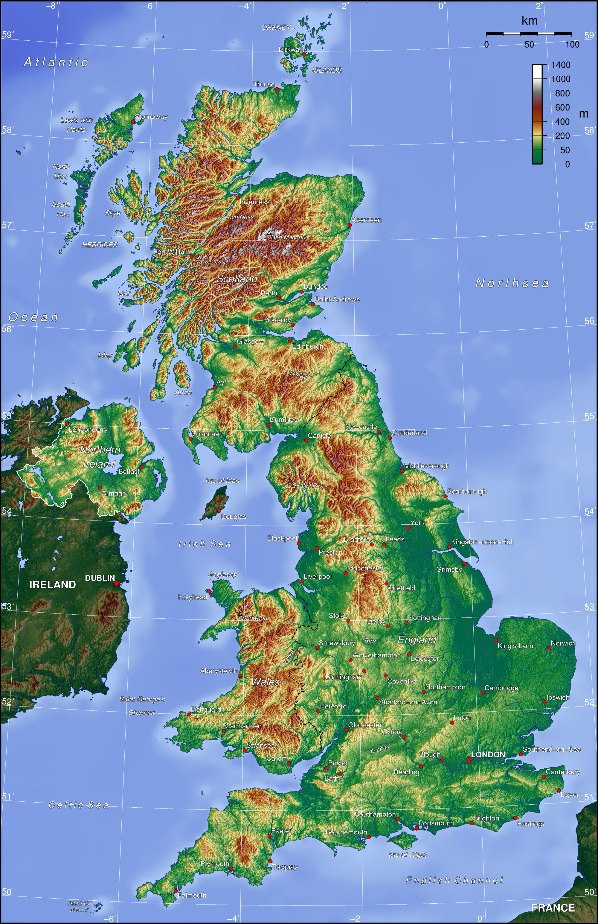
How come we don't have any decent map indicating the main rivers in England or the UK, or just in individual regions? Is it any lack of agreement over the question that hangs above the previous discussion, namely which rivers constitute the principal ones, or are there copyright-related problems which prevent any such map from being created for Wikipedia? The latter seems unlikely to me given what maps we do have at Commons. Some manual highlighting here or here, for instance, could be one way forward, but then how about svg maps? This one looks potentially workable, if much less detailed. Cavila (talk) 07:11, 18 May 2010 (UTC)
- Alright, I've created a map myself, though I'm not entirely happy with the selection (where's the Wye, for instance?). Cavila (talk) 10:54, 20 May 2010 (UTC)
- Nice map but......sometime ago the article was Rivers of Britain and then it was split up into England, Wales and Scotland for reasons possibly known to those who made the decision; which means that the map also probably needs dividing into three sub-equal parts with rivers such as the Welsh Dee, the Wye, the Tweed and the Esk featuring in at least two of the maps each. Nevertheless, a nice map !. Velela Velela Talk 12:34, 20 May 2010 (UTC)
- True, but it seemed to me easier to crop the image at a later stage rather than do things the other way around. Anyway, here's a new one, derived from the previous svg-map. Thanks to Notuncurious, readers of "Rivers of Wales" and "Rivers of Scotland" are already well served by being presented with excellent maps. See also here for what's currrently available at Commons). Cavila (talk) 14:40, 20 May 2010 (UTC)
- Nice map but......sometime ago the article was Rivers of Britain and then it was split up into England, Wales and Scotland for reasons possibly known to those who made the decision; which means that the map also probably needs dividing into three sub-equal parts with rivers such as the Welsh Dee, the Wye, the Tweed and the Esk featuring in at least two of the maps each. Nevertheless, a nice map !. Velela Velela Talk 12:34, 20 May 2010 (UTC)
Choice of start/finish point[edit]
There may well be a good reason for this but why do we start this list at The Lizard rather than Land's End which is a more frequent starting point for descriptions of the British (or indeed English) coast. Geopersona (talk) 04:50, 26 September 2010 (UTC) And, after all, checking the page on the English Channel this seems to be defined by the IHO with reference to Land's End rather than the Lizard. Geopersona (talk) 04:52, 26 September 2010 (UTC)
- Or, alternatively why not start at the Solway Firth on the Scottish border and go around the coast anti-clockwise to the Tweed on the Scottish border again? Any takers? Geopersona (talk) 12:40, 2 October 2010 (UTC)
Omissions from map[edit]
Belatedly, I've just noticed two major omissions from the map - the River Wye and the River Mersey. There may be others - I haven't done an exhaustive check. What were the criteria for inclusion in the map? Ghmyrtle (talk) 07:49, 26 September 2010 (UTC)
- Cavila and Ghmyrtle mention the omission of the Wye but, to my mind, the greater sin is the omission of a part of England from the map at all ie that bit extending up to the Tweed - and necessarily omitting that important transnational watercourse. :-) Geopersona (talk) 08:35, 26 September 2010 (UTC)
- Note - no criticism of Cavila intended here - Cavila is to be thanked for supplying a map for us all in the first instance - something I've not been able to do!! Geopersona (talk) 15:11, 26 September 2010 (UTC)
- Thanks, but with the right software anyone could have produced such a map based on the original map available from Wiki Commons. I haven't been able to add anything apart from the names, so no doubt there will be omissions. One editor who has been responsible for some of the most detailed river maps I've seen on Wikipedia is Notuncurious, so I'll drop him a note and ask if he would be willing to produce a better map. Also, now that the Ordnance Survey has made some of their materials freely available [1], it should be possible to create new customised svg maps which are (a) georeferenced and (b) contain more detail if and when necessary. I hope that anyone with more experience in map-making than myself will pick up on this. Cavila (talk) 09:03, 10 October 2010 (UTC)
- I can upload a map to replace the current one, with as much or as little as is desired for any and all parts of the island. As this is an "overview" map, I presume that means the major rivers/catchments/regions of interest, both modern and historical, on a monochrome map not unlike the current one. Just lay out here what is wanted ... I have the whole island mapped out in rather tedious detail, with most if not all of the significant rivers and lakes. Regards, Notuncurious (talk) 15:41, 10 October 2010 (UTC)
- Sounds good! The present one isn't too bad - it's just that it doesn't cover the northern bit of England (inc R Tweed) and as has been pointed out, there are one or two major rivers that might be worth including such as the Mersey and the Wye. Others may have other thoughts . . . cheers and thanks. Geopersona (talk) 17:13, 10 October 2010 (UTC)
- Could he upload it to your sandbox version to let us have a look? Motmit (talk) 17:25, 10 October 2010 (UTC)
- I can upload a map to replace the current one, with as much or as little as is desired for any and all parts of the island. As this is an "overview" map, I presume that means the major rivers/catchments/regions of interest, both modern and historical, on a monochrome map not unlike the current one. Just lay out here what is wanted ... I have the whole island mapped out in rather tedious detail, with most if not all of the significant rivers and lakes. Regards, Notuncurious (talk) 15:41, 10 October 2010 (UTC)
- Have a look at THIS MAP. I think that there were several errors in river courses on the present map (Torridge, Itchen, Parrett, Aire, and maybe others), which should be correct now; and I assumed that the choice of N. Tyne (not S. Tyne) was intentional. If it is acceptable, simply plug it into the article. Else please comment here. Regards, Notuncurious (talk) 00:44, 11 October 2010 (UTC)
- That's a really handsome map. I think there are still some errors on this one - on the underlying river detail in blue rather than the black lines. There is a section of the Derwent missing in N Yorks and a long section of the Shropshire Union Canal is there in Cheshire masquerading as a river but with perhaps a part of the nearby River Weaver missing - it takes a different course. Give me time to check it out and I'll see if anything else needs tweaking. Still it will be good to have this one. Thanks Notuncurious. Geopersona (talk) 06:27, 11 October 2010 (UTC)
- It's a very good map. It does seem to show canals generally - not just the one mentioned by Geopersona - which may well cause some confusion. Can I also ask whether the rivers named were decided on the basis of any objective criterion, such as length? If not, we should try to be consistent, and, if they are, perhaps the criterion should be stated ("Rivers over xx km long are shown in black", or similar). Ghmyrtle (talk) 08:24, 11 October 2010 (UTC)
- That's a really handsome map. I think there are still some errors on this one - on the underlying river detail in blue rather than the black lines. There is a section of the Derwent missing in N Yorks and a long section of the Shropshire Union Canal is there in Cheshire masquerading as a river but with perhaps a part of the nearby River Weaver missing - it takes a different course. Give me time to check it out and I'll see if anything else needs tweaking. Still it will be good to have this one. Thanks Notuncurious. Geopersona (talk) 06:27, 11 October 2010 (UTC)
- Have a look at THIS MAP. I think that there were several errors in river courses on the present map (Torridge, Itchen, Parrett, Aire, and maybe others), which should be correct now; and I assumed that the choice of N. Tyne (not S. Tyne) was intentional. If it is acceptable, simply plug it into the article. Else please comment here. Regards, Notuncurious (talk) 00:44, 11 October 2010 (UTC)
When I went through the island for rivers and checked them out for accuracy (eg, via terrain feature on google maps), I had a major problem distinguishing canals from rivers unless it was obvious—I will appreciate any corrections, Geopersona, please take as much time as you need and be as thorough as seems practical, noting anything that should be corrected. I have all the rivers by name, so you can refer to them that way. (minutia: if you think something is wrong but aren't sure and can't verify, mention the fact and we can go from there)
For canals, it would be good if someone put together a list and came up with a reliable way to map them, both to clean up the map in question here, and for their own sake ... History_of_the_British_canal_system is already an article, and there is a also Template:Canals of the United Kingdom, neither with a map.
I suspect the choice of rivers was arbitrary ... the Medway was famous in AD 43, perhaps not since. The Itchen is probably there to fill out a blank space or because Winchester is on it. Some other rivers probably added to fill out blank spaces, or because it has particular interest to the original compiler of the list.
An error not previously noted: France, like Scotland and Wales, is not a part of England ... I'll shade it out when I update the map. Perhaps a least-bad way to organize the rivers is by catchment, but that's no more than a casual bystander's comment. Regards, Notuncurious (talk) 15:52, 11 October 2010 (UTC)
- Will take a closer look. I think the choice of rivers will need to be somewhat arbitrary otherwise certain areas of the country would be devoid of highlighted rivers as there no rivers above a certain length eg SW Peninsula - but I'll have think about it. cheers Geopersona (talk) 17:21, 11 October 2010 (UTC)
- I didn't know if there was a specific reason why the River Torridge was included but not the River Taw, for example. It would probably be useful to have some criteria, and state somewhere what they are. Ghmyrtle (talk) 11:08, 12 October 2010 (UTC)
- Given the disparity in river lengths from region to region but the desirability, as I see it, of including the more significant in each then that calls for the abandonment of 'absolute' criteria. My own feelings are that I would show the: Arun rather than the Itchen, in SE England (longer and fills the gap better), Lea (Thames left-bank tributary) (major catchment), Taw rather than the Torridge, in SW England (longer, and further from Tamar), Derwent (Trent left-bank tributary) in N Midlands (important N Midland river in a gap area), Yorkshire Derwent (filling in its currently missing middle section), Wensum in East Anglia (currently nothing in the east), South Tyne, in addition to the North Tyne (parity for the two forks), northward extension of the Wiltshire Avon (to make the most of the extent of the river) and two optional additions: Lune in NW England (and extending north beyond its current blue limit) and Wear in NE England
- I didn't know if there was a specific reason why the River Torridge was included but not the River Taw, for example. It would probably be useful to have some criteria, and state somewhere what they are. Ghmyrtle (talk) 11:08, 12 October 2010 (UTC)
- The upper Trent (black) needs correcting (it doesn't 'hook over') as does the Weaver (blue), as both presently incorporate sections of canal. There are bits of canal (blue) appended to the Dee in Cheshire which want removing. cheers Geopersona (talk) 19:22, 12 October 2010 (UTC)
- I'm curious as to why you feel the map should show a regular distribution of named rivers across regions. To me, a map of "major rivers" should, by default, show the major rivers as defined by length, or some other criterion such as rate of flow. It would be interesting to have the views of others. Ghmyrtle (talk) 20:06, 12 October 2010 (UTC)
- Question is what function we see the map as performing. Without being considerably more detailed, it cannot pretend to be a significant adjunct to the text of the article. I see it as serving to sketch out the English rivers, aiding navigation through the bullet-pointed list for those without an intimate acquaintance with the subject. Spotting a Wensum or an Avon on the map and matching it with their occurrence in the list can help track down these and lesser watercourses. Perhaps it also serves as an illustration to pull in the reader and excite their curiosity. We can title the map as we see fit - the current version uses the phrase 'some of the main rivers indicated', which of course could refer to a selection of watercourses of almost any size. Geopersona (talk) 20:37, 12 October 2010 (UTC)
- I'm curious as to why you feel the map should show a regular distribution of named rivers across regions. To me, a map of "major rivers" should, by default, show the major rivers as defined by length, or some other criterion such as rate of flow. It would be interesting to have the views of others. Ghmyrtle (talk) 20:06, 12 October 2010 (UTC)
- The upper Trent (black) needs correcting (it doesn't 'hook over') as does the Weaver (blue), as both presently incorporate sections of canal. There are bits of canal (blue) appended to the Dee in Cheshire which want removing. cheers Geopersona (talk) 19:22, 12 October 2010 (UTC)
- Sorry about the long delay in responding, I got waylaid. Have a look at THIS UPDATE; I think I got all of the things mentioned above. Added the River Yare, since the River Wensum is tributary to it. We can do another round for refinement, if you like; BTW, I just picked the title ... it can be whatever you want. Regards, Notuncurious (talk) 23:08, 23 October 2010 (UTC)
Proposed re-structuring of article[edit]
I'm finding now, both whilst editing and whilst viewing, that given the increasing numbers of entries in the list/s, many of the sections in this article are becoming more difficult to navigate, more difficult to alight on particular watercourses and the wider catchments to which they belong. I propose therefore that we consider how the article might best be restructured. Some time ago, I set each of the watercourses in its sister list for Wales under catchment headings - that seemed to work though there are fewer w/courses for Wales in any case. We could adopt that approach though the nav panel at the start of the article then becomes rather large itself! An interim measure would see the existing section boundaries altered giving us more sections but with fewer entries in each. Any thoughts? Geopersona (talk) 12:51, 26 September 2010 (UTC)
- In fact the nav panel need not be larger if individual catchments are separated out but not as section headings but rather with emoldened and/or large font text. Geopersona (talk) 10:39, 3 October 2010 (UTC)
- I have placed a version of the 'List of rivers of England' page at List of rivers of England (proposed change)|. I would welcome comment on it - for or against, provided its constructive! Geopersona (talk) 20:17, 3 October 2010 (UTC)
I have now made the change to the article. The number of rivers has risen greatly in certain catchments where the list was very much incomplete beforehand. I have also indicated whether rivers are main stem, left or right bank tribuaries. In the course of re-structuring it became apparent that many editors had misunderstood the original layout and arranged tributaries in an order contrary to that of the majority (as described in the introductory text). I have attempted to address this, though I haven't been able to determine the locations and relationships of a few watercourses, and so they have been assigned question-marks (?) temporarily. Any assistance with these would be welcome.
There are also a substantial number of tributaries in two particular catchments which I have not assigned either L or R to; these are the Mersey and Thames catchments. In the first case they include large numbers of relatively minor streams and in the latter a large number of subterranean watercourses and others whose course through London is difficult to determine simply from OS 25K and 50K maps. Attention from other editors to these areas would be most welcome. The changes to this article bring it into line with the articles for Scotland and Wales. I hope folks find them beneficial - I would emphasis that the new material is very much based on the hard work of many previous editors. cheers Geopersona (talk) 18:00, 12 December 2010 (UTC)
Re-visiting the issue of what to include and what to leave out[edit]
Please see the discussion Talk:List of rivers of Wales#Small streams - where do we draw the line? A proposal. It is pertinent to this page too and its Scottish equivalent. thanks Geopersona (talk) 08:14, 10 October 2010 (UTC)
River Biem[edit]
Anyone know of a reference for the River Biem which purports to be a tributary of the River Soar in the Trent/Humber catchment? I've failed to find it on OS 25K, 50K and 1" mapping cheers Geopersona (talk) 09:20, 11 December 2010 (UTC)
- Do you mean the River Biam ?, which flows through Aylestone meadows in Leicester. Jokulhlaup (talk) 19:19, 22 February 2013 (UTC)
River Roden, Berkshire[edit]
Again, can anyone reference this river? It purports to be a tributary of the River Pang in the Thames catchment, joining the Pang at Compton but it does not appear on the OS 25K or 50K maps though there are one or two 'Roden' place names nearby. cheers Geopersona (talk) 11:11, 11 December 2010 (UTC)
Map again[edit]
I've just spotted another minor error on the map, in London: The canal system (Grand Union, Paddington Arm etc) is shown as part of the River Colne. The blue squiggle representing the latter therefore appears flow east, picking up the River Brent as a left-bank tributary, and flow into the Lea. It should actually meet the Thames at Staines (upstream of the River Wey), while the Brent should continue south to the Thames at Brentford. Pterre (talk) 18:27, 11 December 2010 (UTC)
- I've double-checked and you are quite correct. Thank you for finding the error. I'll fix this, but am in the middle of something else at the moment, so there will be a delay. If something arises and it needs fixing immediately (or if I seem to have let it slip), please let me know, and also point out any other errors that may be found. I've come across a usable canal map at www.aina.org.uk, drawn by Oxford Cartographers, and will use it to clean things up a bit.
- I also have copies of Hoxley's 1933 maps from Woodlands and Marshlands of England, drawn under the direction of the British Association, and they seem to be very good—the maps focus on prehistoric and non-industrial Britain and so may be of particular use where watercourses have been changed or covered by urban growth (eg,. London) ... if you can find it at a library or bookstore I would suggest you have a look to see if it fits your purposes (perhaps, take along a magnifying glass along to see the finest detail). Regards, Notuncurious (talk) 19:03, 12 December 2010 (UTC)
- Updated the map. Regards, Notuncurious (talk) 00:09, 14 December 2010 (UTC)
- Notuncurious - you wouldn't care to do a similar map for the List of rivers of Scotland article would you? There's one there presently but it wasn't designed for the job and only incidentally shows rivers - a Scottish version of your English one would really enhance the page imho. cheers Geopersona (talk) 05:19, 17 December 2010 (UTC)
- Updated the map. Regards, Notuncurious (talk) 00:09, 14 December 2010 (UTC)
Catches with catchments[edit]
Categorising rivers into catchments is not always so straightforward as might first be imagined. There are those rivers like the Yorkshire Ouse and the River Trent which discharge into a common estuary - the Humber in their case. The 'River Humber' (as it is often known) is one of a small group of 'rivers' which are entirely estuarine, they have no non-tidal parts. In restructuring the article, I have chosen to adopt the Trent and Ouse as first-order rivers ie main stems rather than include the Humber as such - it helps with the layout of the article as much as anything. Suffolk's River Orwell is the tidal portion of the River Gipping - I have chosen to include them as one river (with wikilinks to separate articles on both) rather than have the Gipping as a tributary of the Orwell. The Thames and certain other southern English rivers have various distributaries which part from the main river then reconnect further downstream. The most significant of these have their own names and so I have included them. Though most may not warrant their own Wikipedia articles, I took the line that possession of a 'river name' of their own merited their inclusion in this list since it would assist anyone searching for reference to them and understanding their geographical context. Similar issues arise in The Fens where artificial drainage channels (often going by the name of '... river') cross-link originally naturally-directed watercourses and serve to make the picture somewhat complex. It is inevitable that in trying to impose order on an assemblage of features which are not constrained by our artificial rules, there will be inconsistenecies. It would be useful to debate these. cheers Geopersona (talk) 06:58, 13 December 2010 (UTC)
Sections by coast[edit]
In the recent reorganisation of the list we have lost the division by coast (North Sea, English Channel, Atlantic Ocean and Irish Sea). This seems to me such a fundamental distinction that it should be restored.
I am also doubtful about the subheadings by catchment. They seem to duplicate info which is obvious from the list, and unnecessarily lengthen the list. Any comments? --Mhockey (talk) 11:36, 31 December 2010 (UTC)
- Mhockey - I'm open to further improvements being made - though I've done a considerable amount of work on it I realise that it's not 'my article' to do with as I like but a shared responsibility with all who have a care to contribute. I added the subheadings by catchment in the same style as the river lists for wales and Scotland beacuse I believe it makes it easier when scrolling through the list to alight on a particular catchment - the bold words standing ouit as they do. I would agree though particularly in the case of those catchments where there are perhaps only one or two watercourses, the main stem' and a tributary or two' that they seem more redundant in those cases. There may be an argument for grouping some of these minor ones - indeed I have done that to a certain extent and labelled them 'simple coastal catchments or similar. I did want to avoid lumping in any watercourses with adjacent major catchments.
- As regards the North Sea, Atlantic distinctions etc then I do see what you're getting at. These labels could be added at title level though that would add to the length of the list thus: Geopersona (talk) 20:48, 1 January 2011 (UTC)
Flowing into Irish Sea
- 1 Cumbrian coast
- 2 Lancashire and Cheshire Coast
Flowing into the Atlantic & Western Approaches
- 3 Rivers Severn and Wye
- 4 Bristol Channel
- 5 Atlantic Coast of Devon and North Cornwall
Flowing into the English Channel
- 6 South Coast of Cornwall and Devon
- 7 Coast of Dorset and Hampshire
- 8 Isle of Wight
- 9 Coast of South East England
Flowing into the North Sea
- 10 Thames Estuary
- 11 East Anglian Coast
- 12 Lincolnshire Coast and The Wash
- 13 Humber catchment
- 14 Yorkshire Coast
- 15 North East England
- . . . though I see you've started on a useful alternative approach in Cumbria - let's think about what works best. cheers Geopersona (talk) 20:56, 1 January 2011 (UTC)
- I've added four 'super-sections' to assist in navigating the page in line with Mhockey's suggestion. cheers Geopersona (talk) 21:06, 4 January 2011 (UTC)
- . . . though I see you've started on a useful alternative approach in Cumbria - let's think about what works best. cheers Geopersona (talk) 20:56, 1 January 2011 (UTC)
An error in a link needs correction[edit]
The river that exits at Lyme Regis (the river Lyme) is listed here as the "River Lim" and the link directs you to a river in Serbia. This needs correcting! — Preceding unsigned comment added by 24.22.220.193 (talk) 03:17, 15 November 2011 (UTC)
- I've altered this to a redlink - would anyone care to add the article? Pterre (talk)
- The river is actually known as the Lym or Lim - spellings vary - but not the Lyme. Ghmyrtle (talk) 10:18, 15 November 2011 (UTC)
- I've added a subsection on the river at Lyme Regis and put in a redirect to that location from the list for the present. I didn't think the river could justify a separate article at present. cheers Geopersona (talk) 19:26, 4 November 2012 (UTC)
- The river is actually known as the Lym or Lim - spellings vary - but not the Lyme. Ghmyrtle (talk) 10:18, 15 November 2011 (UTC)
Wikilink problem[edit]
Under the Welland Catchment is 'New River', which links to a cut near London. This is obviously wrong. What should it link to? --Robert EA Harvey (talk) 08:03, 4 November 2012 (UTC)
- Link fixed - it now points at New River, Lincolnshire. There is no relevant article at present so the link is red. Velella Velella Talk 14:36, 4 November 2012 (UTC)
- There is also a link to 'New River' upstream of Wicken Lode in the Great Ouse catchment that is not the London New River. Pterre (talk) 14:54, 4 November 2012 (UTC)
- That one fixed too. Now points to New River, Cambridgeshire. Velella Velella Talk 17:22, 4 November 2012 (UTC)
- Strikes me that the London example mentioned by Robert above - presently New River (England) - ought to be retitled New River, London if we are potentially to have articles on several English 'New Rivers'. I think perhaps that the Cambs New River ought simply to be included within Wicken Lode (which is already detailed at Cambridgeshire Lodes since it is simply the minor upstream continuation of that watercourse. cheers Geopersona (talk) 19:40, 4 November 2012 (UTC)
- Not unlike the way Vernatt's Drain is linked to a section of Spalding? --Robert EA Harvey (talk) 02:36, 5 November 2012 (UTC)
- Strikes me that the London example mentioned by Robert above - presently New River (England) - ought to be retitled New River, London if we are potentially to have articles on several English 'New Rivers'. I think perhaps that the Cambs New River ought simply to be included within Wicken Lode (which is already detailed at Cambridgeshire Lodes since it is simply the minor upstream continuation of that watercourse. cheers Geopersona (talk) 19:40, 4 November 2012 (UTC)
- That one fixed too. Now points to New River, Cambridgeshire. Velella Velella Talk 17:22, 4 November 2012 (UTC)
River Wey branches[edit]
I am not sufficiently sure of my facts to edit the article, which presently says
- River Wey (R)
As I understand it, the N branch is on the left when looking downstream, the south on the right. Therefore the artcle needs an edit. Is my understanding right? -- SGBailey (talk) 15:35, 12 February 2013 (UTC)
Just to confirm things, here is ascii art of my understanding of the naming
River A
-----------\
            \    River C
       x     >-------------. (The sea)
            /
------------
River B
If River A and River C are the same river and River B is the tributary we have
- River AC
- River B (R) ('cos I'm standing at 'x' looking towards the sea)
If River B and River C are the same river and River A is the tributary we have
- River BC
- River A (L) ('cos I'm standing at 'x' looking towards the sea)
If all rivers are distinct, we have
- River C
- River A (Ls) ('cos I'm standing at 'x' looking towards the sea)
- River B (Rs) ('cos I'm standing at 'x' looking towards the sea)
Is this right? -- SGBailey (talk) 07:03, 18 February 2013 (UTC)
- Sounds right to me, as long your looking downstream when your looking towards the sea. Jokulhlaup (talk) 19:14, 22 February 2013 (UTC)
Water Framework Directive (WFD) list of waterbodies[edit]
As part of the WFD the EA have produced a list of waterbodies (Rivers, Lakes etc) the files are WFD csv files The list is not perfect, but it is accessible and may help with some of the queries raised on this page - the bonus is that it also lists river lengths and catchment areas.
In addition, on the EA website What’s in your backyard provides an interactive map, where you can check to see the extent of these waterbodies. By changing the 'Other topics in this Area' to 'Risk of flooding from Rivers and the Sea' you can then see the extent of the EA Main Rivers, although you may have to zoom in to get them to appear.
SEPA have done something similar here but not as csv files just a long list of waterbodies.
Hope this helps Jokulhlaup (talk) 19:43, 19 February 2013 (UTC)
Link Error[edit]
In this list the Glaze Brook is correctly shown as a tributary of the Devon Avon. However Glaze Brook currently links to a page about a completely different river near Manchester. Sorry I don't yet know how to change this otherwise I'd do it myself. 86.150.255.84 (talk) 17:17, 7 February 2019 (UTC)
- Thanks for reporting the problem. There is no article on the Devon river as yet so I have just red-linked it for now to Glaze Brook, Devon. Keith D (talk) 21:39, 7 February 2019 (UTC)
- Good, but I've now noticed Red Brook has a similar issue, OS Landranger map 202 confirms there's a Red Brook feeding Bala Brook which is a tributary of the Devon Avon but the list currently links to an unrelated Red Brook in Lancashire. By the way while we're here I can't see Scad Brook labelled on that particular map but I'd like to point out that it is nonetheless well worth keeping a place for it on the list because it's significant due to its association with a known pre-historic settlement http://www.dartmoorwalks.org.uk/resource/site.php?SiteID=54 (I mention this partly in response to a comment above from one of our North American cousins who seemed surprised that we should attach significance to such small features in the landscape) 86.150.255.84 (talk) 23:38, 9 February 2019 (UTC) OK I've sorted Red Brook here by copying the edit pattern from Glaze Brook - so hope I've done that right, seems to do the trick. However although that was previously linking directly to the Manchester Red Brook there is also a Red Brook disambiguation page so I'm thinking at some stage the Devon one needs to be up there too?86.150.255.84 (talk) 17:01, 10 February 2019 (UTC)
Tees catchment[edit]
Chocolateer in his edit summary said "traditional Yorkshire ends with the Tees as the border into Durham therefore right of the Tees is Yorkshire and Left is County Durham. Redcar is not the traditional border." That may be so but it misses the point - the choice of Redcar is simply to allow the Tees to feature as a catchment in its entirety. Choosing the Tees as the end of the section and then dividing it into a left and a right catchment made it inconsistent with the approach used for all the other rivers in this list which is why I've returned the list to its earlier state. This list is not an attempt to describe county boundaries, old or new, it's about rivers and their tributaries, a purely physical feature of the English landscape. thanks Geopersona (talk) 06:02, 28 April 2020 (UTC)
Welland catchment[edit]
This is confusing and may require further consideration to accurately describe what is going on between Market Deeping and Peterborough. The main flow of the Welland appears to continue as the Maxey Cut whilst two watercourses (one labelled as River Welland) head off NE to rejoin the waters of the Maxey Cut east of Northborough. Then there's the "River Welland (old course)" - confusing? cheers Geopersona (talk) 06:10, 28 April 2020 (UTC)
Blind Yeo[edit]
I added an item and link to the existing article for Land Yeo that flows through Clevedon to the sea. From what I understand Blind Yeo is a flood relief channel for Land Yeo around Clevedon and empties into the sea so isn't a River ("A river is a natural flowing watercourse..."). I've not removed the item yet.
The neighbouring Middle Yeo seems to be another named drain rather than a river.
Platinke (talk) 18:08, 3 October 2020 (UTC)
- According to Somerset Rivers the Blind Yeo is an artificial relief channel for the Kenn. The list has other artificial watercourses, other than canals, eg the Jubilee River, Duke of Northumberland's River and so on. I woud say leave it in. Murgatroyd49 (talk) 18:41, 3 October 2020 (UTC)
Referencing watercourses[edit]
There is a note at the foot of the article explaining that the details in the list are obtained from the OS 25K, 50K and 1" maps and that holds generally true. I've become aware that there are some which do not appear on those map series but which nevertheless are named on OS 6" or 25" maps - it would be useful for editors to record that detail, though going back through the material might take a while. Looking at the recent changes by an IP editor to tributaries of Malham Beck/Gordale beck, I also note discrepancies between OS maps of different date and different series - not wholly surprising - but, which is to take preference - the older more detailed map or the more recent one? Hell Gill Sike and Hanlith Gill (Sike) are an example. Geopersona (talk) 07:04, 20 December 2020 (UTC)
Main rivers[edit]
The term 'main rivers' is, as has been noted above, defined statutorily and does not coincide with what a member of the public might consider to be the key watercourses in an area. Perusing the maps of main rivers available on-line via the Environment Agency and Natural Resources Wales, shows many significant watercourses to be omitted from the map/list and many trivial* (and often un-named) ones to be included. *'Trivial' in the sense of their presence in the landscape - length, flow etc but presumably not trivial when it comes for example to their potential for causing disruption through flooding. Thus the text which previously suggested the list aspired to inclusion of all of the 'main rivers' (as defined and mapped) seems misplaced, hence I have removed much of it and pointed out the mis-match between 'main rivers' and watercourses which might be deemed significant enough for inclusion on this list. I viewed the EA map via a link from https://www.gov.uk/government/collections/main-river-map-for-england-proposed-changes-and-decisions and the NRW map at https://datamap.gov.wales/maps/new?layer=inspire-nrw:NRW_MAIN_RIVERS#/ thanks Geopersona (talk) 17:31, 12 November 2022 (UTC)
- List-Class UK geography articles
- High-importance UK geography articles
- List-Class River articles
- High-importance River articles
- List-Class England-related articles
- High-importance England-related articles
- WikiProject England pages
- List-Class List articles
- Low-importance List articles
- WikiProject Lists articles