
Talk:Red Hill Valley Parkway
| This article is rated B-class on Wikipedia's content assessment scale. It is of interest to the following WikiProjects: | |||||||||||||||||||||||||||||||||||||||
| |||||||||||||||||||||||||||||||||||||||


References[edit]
See Wikipedia:Footnotes for an explanation of how to generate footnotes using the <ref(erences/)> tags —Preceding unsigned comment added by Nhl4hamilton (talk • contribs) 05:32, 29 January 2008 (UTC)
Name[edit]
The Red Hill expressway has been in the hopper for more than 50 years, but it took a group of city councillors less than half an hour to pick a formal name for it.
And the name is -- drum roll, please.
The Red Hill Valley Parkway.
Despite fierce lobbying by citizens who want the controversial road named after former mayor Jack MacDonald, the group tasked with coming up with a title voted 4-1 for that more or less obvious choice.
(Hamilton Spectator, 4 May 2005)
POV[edit]
I found this article to be too biased in favour of the construction, which has been a major, well-publicized controversy. I have made a relatively minor change in order to provide some more balance. --Spmarshall42 18:55, 12 July 2006 (UTC)
removed stuff on Freeman Interchange[edit]
Yes, this new highway will be taking all the east-west traffic out of the freeman interchange (and diverting in through the east end and the mountain, thus finally proving the DiIanni city council to have been idiots - just wait and see). But the RHVP is not "needed" because of any supposed deficiency in the Freeman Interchange. The capacity of the Freeman ramps was determined by MTO without any assumption that RHVP would be completed, and with current data - and if MTO thought the RHVP was needed to reduce congestion on their highways, they would have paid for the RHVP and would own it.
I know about Freeman Interchange because I was out there before it was open to traffic, inspecting the bridges.
Just putting in my own 2 cents, here, since I know how MTO works and have worked on a lot of the highways around here. AllGloryToTheHypnotoad 01:05, 7 May 2007 (UTC)
Terminus[edit]
Darnall Road is officially on the RHVP and its last exit, not the Linc. I've reverted the article to my previous edit. One can take a look at the linked streetview shots to see the Begins signage and their location for themselves.
This is nonesense, based on guess work and speculation. Dartnall Road interchange was built as the last on the Linc and Mud Street was the first interchange on the RHVP. See The Red Hill Valley Project at the City of Hamilton. There is no substitute for proper research. Secondarywaltz (talk) 14:46, 21 January 2012 (UTC)
- The signs at Mud Street also point to both highways. This is because the join is between the interchanges, near Prichard Road, where there is no interchange. Look at the reference I have given above for construction details. Secondarywaltz (talk) 16:22, 21 January 2012 (UTC)
- I was referencing the signs on the Red Hill / Linc that indicate that one ends and the other begins (the second url). When they were constructed, the part that became the Linc (both parts were originally the Red Hill Creek Expressway) forced drivers off at Dartnell Road. The RHVP was constructed several years later connecting with that and completing the interchange. The construction maps are just going to show the work left to complete. We need a post construction ref to know what the actual terminus of the roads are. I could also fire off an email to the Hamilton Public Works Department and see what the official word is (even though we can't use it as a ref). - ʄɭoʏɗiaɲ τ ¢ 16:33, 21 January 2012 (UTC)
- The signs at Mud Street also point to both highways. This is because the join is between the interchanges, near Prichard Road, where there is no interchange. Look at the reference I have given above for construction details. Secondarywaltz (talk) 16:22, 21 January 2012 (UTC)
- OK I see that now - thanks. By-laws define these limits. Cities don't just stick up signs, there is an official process that takes place dedicating the road as a public highway - but you already know that. Here is a report] on a By-law to establish the RHVP which shows the limit at Prichard Road. Perhaps that has subsequently been changed - the city will let you know that. An amending By-law might also be available on their web site. That would be convenient. Secondarywaltz (talk) 17:01, 21 January 2012 (UTC)
- If this is true and there was no subsequent bylaw I'm almost wondering if the city screwed up where they put their signs, this wouldn't be the first time something like this has happened and won't be the last. Trust me when I say I was was rather surprised the first time I drove this and saw where the transition signs were located, but it sort of made sense as the extension to Mud Street was an early precursor to the RHVP and constructed separately from the rest of the Linc. I'm not trying to be a prick about this. Still, we need to come to some sort of consensus - do we base these articles on where the City of Hamilton has placed signage to indicate the transition from one highway to the other, or do we base it on the best sourced legal definition if it has not been changed and note the potential signing error? Snickerdo (talk) 16:40, 22 January 2012 (UTC)
- I've fired an email off to the City of Hamilton requesting a bylaw for the formal demarcation line. The way I see it, the bylaws and plans correspond to show what was likely the designation of a right-of-way out of greenspace and parkland, prior to construction. There are further bylaws designating parcels of land with more recent dates, but there is no map and I do not know how to establish where those parcels are. The signs are in the same spot in both directions, which seems intentional; the signs at Dartnall would not show the RHVP for a westbound exit if it becomes the Linc by Upper Gage. - ʄɭoʏɗiaɲ τ ¢ 18:08, 22 January 2012 (UTC)
- Be sure to let us know what they say, I'd be very interested to hear what you find out. The fact that Mud Street and Dartnall both show the RHVP -and- the Linc on their signs make things even more confusing. Snickerdo (talk) 22:17, 22 January 2012 (UTC)
- I found By-Law No. 07-308 referred to in the report above, but could not find any City of Hamilton By-laws with subsequent amendments. Perhaps the legal description in 07-308 does not match the sketch, which shows the dedication as being between Pritchard Road and the QEW. I will also patiently await the answer from the city, which is probably more efficient than searching their entire on-line database of agendas, minutes and reports, where I have been trying to find supporting references for your photographic evidence. Secondarywaltz (talk) 17:46, 23 January 2012 (UTC)
- Either way, the signs speak for themselves regardless of bylaw. If the city does come back and say it ends at Pritchard Road, a decision needs to be made with regards to noting this in the article, because the city has marked the demarcation point with their signage right between Upper Ottawa and Dartnall and that's what people see when they drive. Probably jumping the gun, the city has yet to say anything. Snickerdo (talk) 05:13, 25 January 2012 (UTC)
- Got a response:
- The attached PDF's contain the by-laws outlining the Lincoln M. Alexander (LINC) and Red Hill Valley (RHVP) Parkways.
- There are two blue signs for westbound traffic indicating the LINC "BEGINS" and two green signs for eastbound traffic noting the RHVP "BEGINS". These signs are in the median and right shoulder of the parkway and are located approximately 300m west of the Dartnall Road interchange.
- Regards
- Marco Oddi, P.Eng.
- Senior Project Manager
- Construction Section, Engineering Services Group
- Environment & Sustainable Infrastructure Division
- Public Works Department
- Got a response:
- Either way, the signs speak for themselves regardless of bylaw. If the city does come back and say it ends at Pritchard Road, a decision needs to be made with regards to noting this in the article, because the city has marked the demarcation point with their signage right between Upper Ottawa and Dartnall and that's what people see when they drive. Probably jumping the gun, the city has yet to say anything. Snickerdo (talk) 05:13, 25 January 2012 (UTC)
- I found By-Law No. 07-308 referred to in the report above, but could not find any City of Hamilton By-laws with subsequent amendments. Perhaps the legal description in 07-308 does not match the sketch, which shows the dedication as being between Pritchard Road and the QEW. I will also patiently await the answer from the city, which is probably more efficient than searching their entire on-line database of agendas, minutes and reports, where I have been trying to find supporting references for your photographic evidence. Secondarywaltz (talk) 17:46, 23 January 2012 (UTC)
- Be sure to let us know what they say, I'd be very interested to hear what you find out. The fact that Mud Street and Dartnall both show the RHVP -and- the Linc on their signs make things even more confusing. Snickerdo (talk) 22:17, 22 January 2012 (UTC)
- I've fired an email off to the City of Hamilton requesting a bylaw for the formal demarcation line. The way I see it, the bylaws and plans correspond to show what was likely the designation of a right-of-way out of greenspace and parkland, prior to construction. There are further bylaws designating parcels of land with more recent dates, but there is no map and I do not know how to establish where those parcels are. The signs are in the same spot in both directions, which seems intentional; the signs at Dartnall would not show the RHVP for a westbound exit if it becomes the Linc by Upper Gage. - ʄɭoʏɗiaɲ τ ¢ 18:08, 22 January 2012 (UTC)
- If this is true and there was no subsequent bylaw I'm almost wondering if the city screwed up where they put their signs, this wouldn't be the first time something like this has happened and won't be the last. Trust me when I say I was was rather surprised the first time I drove this and saw where the transition signs were located, but it sort of made sense as the extension to Mud Street was an early precursor to the RHVP and constructed separately from the rest of the Linc. I'm not trying to be a prick about this. Still, we need to come to some sort of consensus - do we base these articles on where the City of Hamilton has placed signage to indicate the transition from one highway to the other, or do we base it on the best sourced legal definition if it has not been changed and note the potential signing error? Snickerdo (talk) 16:40, 22 January 2012 (UTC)
- OK I see that now - thanks. By-laws define these limits. Cities don't just stick up signs, there is an official process that takes place dedicating the road as a public highway - but you already know that. Here is a report] on a By-law to establish the RHVP which shows the limit at Prichard Road. Perhaps that has subsequently been changed - the city will let you know that. An amending By-law might also be available on their web site. That would be convenient. Secondarywaltz (talk) 17:01, 21 January 2012 (UTC)
- the two PDFs just contain lot and parcel numbers, which could very well be verified with a survey of Hamilton (probably only accessible at the city hall), but the response from Marco seems to verify that the signs placed on the parkway are in the proper location, and Dartnall Road is part of the RHVP, not the Linc - ʄɭoʏɗiaɲ τ ¢ 21:31, 26 January 2012 (UTC)
- That's good! But what are the by-law numbers, and are they available at City of Hamilton By-laws on-line? They can then be cited and linked (or LINC-ed), even if they don't have a description that is easily understood, they are still the legal definition. Who can read legal stuff anyway? Oh - I can. I will look for more info on the Concessions and Lots in the original Township, which might help define the dividing point. Thanks. Secondarywaltz (talk) 00:22, 27 January 2012 (UTC)
- The first one (for the Linc) is Regional By-Law R97-077 (A By-Law to Establish and Lay Out Certain Lands as Part of the Lincoln M. Alexander Parkway),[1] which may be hard to find online given its age. The RHVP should be online since its from 2007, City of Hamilton By-Law 07-308 (To Incorporate City Land, Designated as Below, Into the Red Hill Valley Parkway)[2] - ʄɭoʏɗiaɲ τ ¢ 15:46, 27 January 2012 (UTC)
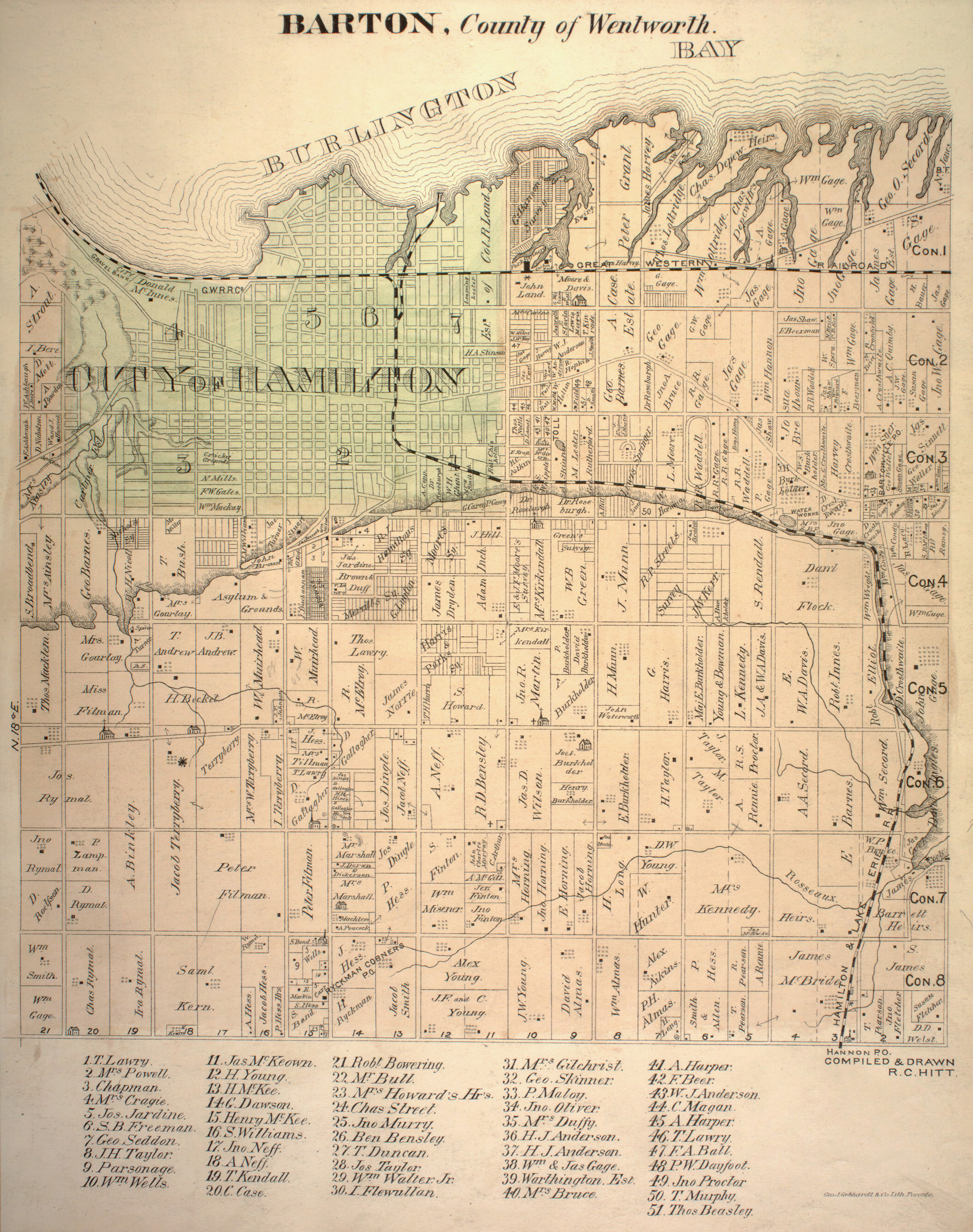
- Hamilton - we have a problem! Pritchard Road is the line between the Township of Barton (see MAP) and the Township of Saltfleet (see MAP), with Rymal Road being the southerly limit of both of them. The jog in the alignment of Rymal at Pritchard shows how Ontario townships often don't match exactly. City of Hamilton By-Law 07-308 which defines the RHVP only includes land in Saltfleet and not any land in Barton. Regional By-Law R97-077, which defines the LINC, does include parts of Lots 1 and 2, Concession 7 in Barton, which are the lots between Pritchard and Dartnall where the highway is built. Did someone put the signs in the wrong place? Should they be "300m east of the Dartnall Road interchange" rather than west? I had hoped we would come up with a solution which would give us proper references rather than Google images, but we see to have uncovered something a little out of sync. Secondarywaltz (talk) 17:01, 27 January 2012 (UTC)
- Oi. This isn't the first time I've run into this problem... For Highway 410 I've got a source from the Star in 1985 saying "its open to here today, next year it will open to there", but the official Ontario road maps show it completed to "there" in 1982. I've responded to Marco with this insight, will see if the city has anything to say... We may have to just indicate in the text, and make the terminus for the two parkways be the other parkway (in the infobox). - ʄɭoʏɗiaɲ τ ¢ 17:31, 27 January 2012 (UTC)
- Could this be a simple East vs. West error? This whole situation seems very odd. I look forward to their response and, hopefully, some clarification. As for the Streetview images, regardless of what the bylaw says, Hamilton has signs that show the demarcation point as West of Darnall Road, so that is what the vast majority of people see and would think. Snickerdo (talk) 22:17, 27 January 2012 (UTC)
- Did you really say "regardless of the law"? I think you fail to understand the impact of these by-laws. If a road is not dedicated as a public highway then it is not subject to the Highway Traffic Act or any relevant municipal by-laws governing local traffic restrictions like parking or speeding. If someone gets a traffic ticket with incorrect information on it, that infraction can be disputed in court. If you were illegally parked on "Queen Street" and get a ticket that says "King Street", then you were obviously not guilty of that. If you are speeding on "The Lincoln M. Alexander Parkway" and get a ticket that says "The Red Hill Valley Parkway", then you are also not guilty as charged. That is why I have been trying to confirm the correct location of those signs with references. Secondarywaltz (talk) 00:12, 28 January 2012 (UTC)
- You're reading way too much into my comments and getting into way too much of a tizzy over this than it warranted. We're talking about a Wikipedia article, not a legal proceeding. If the signs show that one designation begins and the other ends west of Darnall Road, the article should reflect it as such because that's what people see. If Hamilton is unsure of their own bylaws (and frankly, that does not surprise me in the least but that is another discussion well outside the scope of this) that can be noted in the article, but that is ultimately their issue to correct and the article should still note the demarcation point where the signage is because that's what people see. Furthermore, while completely irrelevant to our discussion, if someone got pulled over on what is signed as the Red Hill Valley Parkway but the ticket said Lincoln M. Alexander parkway due to this confusion and someone attempted to fight the validity based on that alone, the Crown could easily ask for the ticket to be amended to note the correct name. Your argument that you are not guilty on that fact alone is therefore wholly incorrect, albeit it is something I'm sure people could try and perhaps - with the right JP - get away with. Therefore, in that specific context you brought up, the bylaw -is- moot and, while something that we should certainly get to the bottom of, is not worth the tizzy and the condescending tone of your reply. Let's stick to the topic at hand - the demarcation point between the two highways, where it is signed - as in, what people see when they drive (how you claimed this was originally research in the first place when you can drive down the highway yourself and see the signs is beyond me, but whatever) and try to figure out what Hamilton says on the matter: Is it a signage error? Do Hamilton officials even know the correct demarcation point? etc etc. Segues into other topics are unnecessary and take away from the intended goal of this discussion. Snickerdo (talk) 04:19, 28 January 2012 (UTC)
- Also I should note - in the context of road designations and responsibility, signage means everything. I have come across more than a few personal injury cases where two jurisdictions (usually the province and a city or region) are fighting over who is responsible for damages due to road defects, and it has come down to the two jurisdictions attempting to claim the other is responsible due to where a sign was placed. While I completely understand the importance of bylaws, signage is extremely important in a legal context as well. But like I said, that's going well beyond the scope of this discussion. I just wanted to point this out before someone tries to say that signs are irrelevant. Snickerdo (talk) 04:32, 28 January 2012 (UTC)
- Oh my! I was hoping to find proper on-line supporting references for your discovery of the signs at an unexpected location on the highway - not upset you. Secondarywaltz (talk) 22:22, 28 January 2012 (UTC)
- Not upset anymore. Your replies just came across as bit condescending and your most recent reply was off-topic and out of context. It's already forgotten. Let's just try to get to the bottom of this so that we can make sure the articles are correct. Sound good? Snickerdo (talk) 01:56, 29 January 2012 (UTC)
- Oh my! I was hoping to find proper on-line supporting references for your discovery of the signs at an unexpected location on the highway - not upset you. Secondarywaltz (talk) 22:22, 28 January 2012 (UTC)
- Did you really say "regardless of the law"? I think you fail to understand the impact of these by-laws. If a road is not dedicated as a public highway then it is not subject to the Highway Traffic Act or any relevant municipal by-laws governing local traffic restrictions like parking or speeding. If someone gets a traffic ticket with incorrect information on it, that infraction can be disputed in court. If you were illegally parked on "Queen Street" and get a ticket that says "King Street", then you were obviously not guilty of that. If you are speeding on "The Lincoln M. Alexander Parkway" and get a ticket that says "The Red Hill Valley Parkway", then you are also not guilty as charged. That is why I have been trying to confirm the correct location of those signs with references. Secondarywaltz (talk) 00:12, 28 January 2012 (UTC)
- Could this be a simple East vs. West error? This whole situation seems very odd. I look forward to their response and, hopefully, some clarification. As for the Streetview images, regardless of what the bylaw says, Hamilton has signs that show the demarcation point as West of Darnall Road, so that is what the vast majority of people see and would think. Snickerdo (talk) 22:17, 27 January 2012 (UTC)
In 1997, the by-law established the lands as Public Highway from Hwy. 403 to the hydro easement located east of Pritchard Road. At that time, it was intended to have one name for the entire Parkway.
In 2005, Council directed staff to change the name of the north-south portion of the Parkway. This created some difficulty in choosing the appropriate demarcation line given that it is a continuous road. It was decided to place the signs some 300 metres west of the Dartnall Road interchange because the Parkway transitions from an urban cross section to a rural cross section at this location.
The 2007 by-law established the remainder of the lands as Public Highway from the hydro easement to the QEW.
I hope that this answers your question and apologize for the delay in responding.
Kind regards
Marco
- . . . . and now I'll be looking at every Hamilton City Council report from 2005!!! Secondarywaltz (talk) 23:09, 2 February 2012 (UTC)
- Oh, wait a minute! That's not what it says. But I am suprised that there is not a subsequent report of some kind rather than "It was decided to place the signs". That sounds very casual, since the prior report and By-laws were very specific. Oh well, thanks for your digging. Secondarywaltz (talk) 23:21, 2 February 2012 (UTC)
- . . . . and now I'll be looking at every Hamilton City Council report from 2005!!! Secondarywaltz (talk) 23:09, 2 February 2012 (UTC)
- Hey - I wasn't kiddin'! City of Hamilton, Office of the City Clerk has online Council Agendas and Minutes since 2001 and By-laws since 2004. Secondarywaltz (talk) 22:36, 3 February 2012 (UTC)
- Well, now we know for sure and the issue is settled. Certainly interesting to see their rationale for the demarcation line, as that is the approximate area where the design switches from the Linc's weird curbed cross-section to the more standard setup that the rest of the RHVP uses. Snickerdo (talk) 05:46, 8 February 2012 (UTC)
- B-Class Canada-related articles
- Low-importance Canada-related articles
- B-Class Ontario articles
- Low-importance Ontario articles
- All WikiProject Canada pages
- B-Class Canada road transport articles
- High-importance Canada road transport articles
- B-Class Ontario road transport articles
- High-importance Ontario road transport articles
- Ontario road transport articles
- Ontario road transport articles with KML
- B-Class Road transport articles
- High-importance Road transport articles