|
Dam in St. Francois Mountains, Missouri | Taum Sauk Hydroelectric Power Station |
|---|
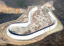 The rebuilt upper reservoir of the Taum Sauk plant, nearing completion in this photo, is the largest RCC dam in North America. | Location of Taum Sauk Hydroelectric Power Station in Missouri | | Country | United States |
|---|
| Location | St. Francois Mountains, Missouri |
|---|
| Coordinates | 37°32′08″N 90°49′05″W / 37.53556°N 90.81806°W / 37.53556; -90.81806 |
|---|
| Purpose | Multi-purpose |
|---|
| Status | Operational |
|---|
| Construction began | 1960 (1960) |
|---|
| Opening date | December 20, 1963 (1963-December-20), April 15, 2010 (2010-April-15) |
|---|
| Construction cost | $45.9 million USD (1963), $490 million USD rebuild (2010) |
|---|
| Owner(s) | Ameren Missouri (previously AmerenUE, formerly Union Electric) |
|---|
| Operator(s) | Ameren Missouri |
|---|
|
| Type of dam | Gravity dam |
|---|
| Height (foundation) | 125 feet (38 m) |
|---|
| Length | 6,800 feet (2,100 m) |
|---|
| Elevation at crest | 1,601 feet (488 m) |
|---|
| Width (crest) | 25 feet (7.6 m) |
|---|
| Width (base) | 150 feet (46 m) |
|---|
| Dam volume | 3,200,640 cubic yards (2,447,060 m3) |
|---|
| Spillways | 1 |
|---|
| Spillway type | Broad crested weir |
|---|
| Spillway capacity | 5,358 cubic feet per second (151.7 m3/s) |
|---|
|
| Total capacity | 4,360 acre-feet (5,380,000 m3) |
|---|
| Surface area | 54.5 acres (22.1 ha) |
|---|
| Maximum water depth | 120 feet (37 m) |
|---|
| Normal elevation | 1,597 feet (487 m) |
|---|
|
| Type of dam | Gravity dam |
|---|
| Impounds | Black River |
|---|
| Height (foundation) | 60 feet (18 m) |
|---|
| Height (thalweg) | 55 feet (17 m) |
|---|
| Length | 390 feet (120 m) |
|---|
| Elevation at crest | 750 feet (230 m) |
|---|
| Width (base) | 75 feet (23 m) |
|---|
| Spillways | 1 |
|---|
| Spillway type | Ogee crest |
|---|
| Spillway capacity | 70,000 cubic feet per second (2,000 m3/s) |
|---|
|
| Creates | Lower Taum Sauk Lake |
|---|
| Total capacity | 6,350 acre-feet (7,830,000 m3) |
|---|
| Catchment area | 88 square miles (230 km2) |
|---|
| Surface area | 395 acres (160 ha) |
|---|
| Normal elevation | 749.5 feet (228.4 m) |
|---|
|
| Coordinates | 37°31′14″N 90°50′04″W / 37.52056°N 90.83444°W / 37.52056; -90.83444 |
|---|
| Operator(s) | Ameren Missouri |
|---|
| Commission date | December 20, 1963 (1963-December-20) |
|---|
| Type | Pumped-storage |
|---|
| Hydraulic head | 860 feet (260 m) |
|---|
| Pump-generators | 2 × 225 MW reversible Francis type |
|---|
| Installed capacity | 450 MW |
|---|
| Capacity factor | 5–8% (70% efficient) |
|---|
| Storage capacity | 8 hours (3600 MW·h) |
|---|
| 2016 generation | -153 GW·h |
|---|
|
Dam in St. Francois Mountains, Missouri | Taum Sauk Hydroelectric Power Station |
|---|
The rebuilt upper reservoir of the Taum Sauk plant, nearing completion in this photo, is the largest RCC dam in North America. | Location of Taum Sauk Hydroelectric Power Station in Missouri | | Country | United States |
|---|
| Location | St. Francois Mountains, Missouri |
|---|
| Coordinates | 37°32′08″N 90°49′05″W / 37.53556°N 90.81806°W / 37.53556; -90.81806 |
|---|
| Purpose | Multi-purpose |
|---|
| Status | Operational |
|---|
| Construction began | 1960 (1960) |
|---|
| Opening date | December 20, 1963 (1963-December-20), April 15, 2010 (2010-April-15) |
|---|
| Construction cost | $45.9 million USD (1963), $490 million USD rebuild (2010) |
|---|
| Owner(s) | Ameren Missouri (previously AmerenUE, formerly Union Electric) |
|---|
| Operator(s) | Ameren Missouri |
|---|
|
| Type of dam | Gravity dam |
|---|
| Height (foundation) | 125 feet (38 m) |
|---|
| Length | 6,800 feet (2,100 m) |
|---|
| Elevation at crest | 1,601 feet (488 m) |
|---|
| Width (crest) | 25 feet (7.6 m) |
|---|
| Width (base) | 150 feet (46 m) |
|---|
| Dam volume | 3,200,640 cubic yards (2,447,060 m3) |
|---|
| Spillways | 1 |
|---|
| Spillway type | Broad crested weir |
|---|
| Spillway capacity | 5,358 cubic feet per second (151.7 m3/s) |
|---|
|
| Total capacity | 4,360 acre-feet (5,380,000 m3) |
|---|
| Surface area | 54.5 acres (22.1 ha) |
|---|
| Maximum water depth | 120 feet (37 m) |
|---|
| Normal elevation | 1,597 feet (487 m) |
|---|
|
| Type of dam | Gravity dam |
|---|
| Impounds | Black River |
|---|
| Height (foundation) | 60 feet (18 m) |
|---|
| Height (thalweg) | 55 feet (17 m) |
|---|
| Length | 390 feet (120 m) |
|---|
| Elevation at crest | 750 feet (230 m) |
|---|
| Width (base) | 75 feet (23 m) |
|---|
| Spillways | 1 |
|---|
| Spillway type | Ogee crest |
|---|
| Spillway capacity | 70,000 cubic feet per second (2,000 m3/s) |
|---|
|
| Creates | Lower Taum Sauk Lake |
|---|
| Total capacity | 6,350 acre-feet (7,830,000 m3) |
|---|
| Catchment area | 88 square miles (230 km2) |
|---|
| Surface area | 395 acres (160 ha) |
|---|
| Normal elevation | 749.5 feet (228.4 m) |
|---|
|
| Coordinates | 37°31′14″N 90°50′04″W / 37.52056°N 90.83444°W / 37.52056; -90.83444 |
|---|
| Operator(s) | Ameren Missouri |
|---|
| Commission date | December 20, 1963 (1963-December-20) |
|---|
| Type | Pumped-storage |
|---|
| Hydraulic head | 860 feet (260 m) |
|---|
| Pump-generators | 2 × 225 MW reversible Francis type |
|---|
| Installed capacity | 450 MW |
|---|
| Capacity factor | 5–8% (70% efficient) |
|---|
| Storage capacity | 8 hours (3600 MW·h) |
|---|
| 2016 generation | -153 GW·h |
|---|
|


.svg)


