
Thor Peak (California)
| Thor Peak | |
|---|---|
 East aspect, from Whitney Portal Road | |
| Highest point | |
| Elevation | 12,306 ft (3,751 m)[1] |
| Prominence | 265 ft (81 m)[1] |
| Parent peak | Mount Whitney (14,494 ft)[1] |
| Isolation | 1.04 mi (1.67 km)[2] |
| Listing | Sierra Peaks Section |
| Coordinates | 36°34′37″N 118°15′57″W / 36.5768549°N 118.2657399°W[3] |
| Geography | |
 Thor Peak Location in California  Thor Peak Thor Peak (the United States) | |
| Location | Inyo County, California, U.S. |
| Parent range | Sierra Nevada |
| Topo map | USGS Mount Whitney |
| Geology | |
| Age of rock | Cretaceous |
| Mountain type | Fault block |
| Type of rock | granitic |
| Climbing | |
| First ascent | Norman Clyde |
| Easiest route | class 2[2] Southwest side |
Thor Peak is a 12,306-foot-elevation (3,751-meter) mountain summit located east of the crest of the Sierra Nevada mountain range in Inyo County, California.[3] It is situated in the John Muir Wilderness on land managed by Inyo National Forest. It is 12.5 miles (20.1 km) west of the community of Lone Pine, and 1.5 miles (2.4 km) east of Mount Whitney. Topographic relief is significant as it rises 3,937 feet (1,200 meters) above Whitney Portal in 1.5 mile. Hikers on the Mount Whitney Trail pass below the impressive south face of the peak.
Climate[edit]
According to the Köppen climate classification system, Thor Peak has an alpine climate.[4] Most weather fronts originate in the Pacific Ocean, and travel east toward the Sierra Nevada mountains. As fronts approach, they are forced upward by the peaks, causing them to drop their moisture in the form of rain or snowfall onto the range (orographic lift). Precipitation runoff from this mountain drains east to Owens Valley via Lone Pine Creek.
Climbing[edit]
The first ascent of the summit was made by Norman Clyde, date unknown.[5]
Established rock climbing routes:[6]
- Southwest side – class 1-2 – First ascent by Norman Clyde
- West Arête – class 2
- Southeast chimney, aka Stemwinder – class 5.4 – FA 1936, by Glen Dawson, Robert K. Brinton, William Rice
- South face – class 5 – FA 1937, by Howard Koster, Arthur B. Johnson, James N. Smith
- Odin’s Wrath – class 5.10d[7]
Gallery[edit]
-
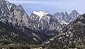
 Thor Peak seen from Outpost Camp along Mt. Whitney Trail
 -
 South aspect
 -
 Thor Peak from Lone Pine Lake along Mt. Whitney Trail
 -
 Thor Peak (center) from Whitney Portal Road
 -
 Thor Peak (left of center) with Mt. Whitney
 -
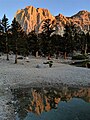 Sunrise on Thor Peak, from Mt. Whitney Trail
 -
 Snow-covered Thor, with Mt. Whitney (right)
 -
 Snow-covered Thor Peak (left), with Mt. Whitney (right)
 -
 Thor Peak in center of photo
 -
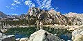
 Thor Peak above Mirror Lake
 -
 from Whitney Portal


.jpg)


See also[edit]
References[edit]
- ^ a b c "Thor Peak, California". Peakbagger.com. Retrieved 2021-05-07.
- ^ a b "Thor Peak - 12,306' CA". listsofjohn.com. Retrieved 2021-05-07.
- ^ a b "Thor Peak". Geographic Names Information System. United States Geological Survey, United States Department of the Interior. Retrieved 2021-05-07.
- ^ Peel, M. C.; Finlayson, B. L.; McMahon, T. A. (2007). "Updated world map of the Köppen−Geiger climate classification". Hydrol. Earth Syst. Sci. 11. ISSN 1027-5606.
- ^ Norman Clyde - Mountaineer, Owensvalleyhistory.com
- ^ John D. and Ruth Mendenhall, Arthur B. Johnson, Braeme Gigas, Howard Koster, A Climber’s Guide to the High Sierra, (1954)
- ^ Pat Brennan, Thor Peak, South Face, Odin's Wrath, American Alpine Journal, 1997
External links[edit]
- Weather forecast: Thor Peak
- Thor Peak climbing: Mountainproject.com