Tomažini
Tomažini | |
|---|---|
 | |
| Coordinates: 45°50′12.93″N 14°35′4.01″E / 45.8369250°N 14.5844472°E | |
| Country | |
| Traditional region | Lower Carniola |
| Statistical region | Central Slovenia |
| Municipality | Velike Lašče |
| Area | |
| • Total | 0.49 km2 (0.19 sq mi) |
| Elevation | 509.3 m (1,670.9 ft) |
| Population (2002) | |
| • Total | 28 |
| [1] | |
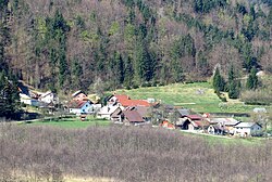
Tomažini (pronounced [tɔmaˈʒiːni]; in older sources also Tomažin)[2] is a small settlement at the northern end of the Mišja Valley (Slovene: Mišja dolina) southwest of Rašica in the Municipality of Velike Lašče in central Slovenia. The area is part of the traditional region of Lower Carniola and is now included in the Central Slovenia Statistical Region.[3]
Name[edit]
The name Tomažini is a collective toponym, referring to a settlement where several people with the surname Tomažin lived.[4]
References[edit]
- ^ Statistical Office of the Republic of Slovenia
- ^ Leksikon občin kraljestev in dežel zastopanih v državnem zboru, vol. 6: Kranjsko. 1906. Vienna: C. Kr. Dvorna in Državna Tiskarna, p. 44.
- ^ Velike Lašče municipal site
- ^ Kladnik, Drago (2000). "Velikolaška pokrajina". Enciklopedija Slovenije. Vol. 14. Ljubljana: Mladinska knjiga. pp. 177–178.
External links[edit]
 Media related to Tomažini at Wikimedia Commons
- Tomažini on Geopedia


