
Typhoon Chanthu (2010)
 Typhoon Chanthu at peak intensity near landfall in Guangdong on July 22 | |
| Meteorological history | |
|---|---|
| Formed | July 17, 2010 |
| Dissipated | July 23, 2010 |
| Typhoon | |
| 10-minute sustained (JMA) | |
| Highest winds | 130 km/h (80 mph) |
| Lowest pressure | 970 hPa (mbar); 28.64 inHg |
| Category 1-equivalent typhoon | |
| 1-minute sustained (SSHWS/JTWC) | |
| Highest winds | 150 km/h (90 mph) |
| Lowest pressure | 963 hPa (mbar); 28.44 inHg |
| Overall effects | |
| Fatalities | 19 total |
| Damage | $818 million (2010 USD) |
| Areas affected | Luzon, Guangdong |
| IBTrACS | |
Part of the 2010 Pacific typhoon season | |
Typhoon Chanthu, known in the Philippines as Tropical Storm Caloy, was a weak typhoon that impacted southeastern China in the 2010 Pacific typhoon season.
Meteorological history[edit]

Tropical storm (39–73 mph, 63–118 km/h)
Category 1 (74–95 mph, 119–153 km/h)
Category 2 (96–110 mph, 154–177 km/h)
Category 3 (111–129 mph, 178–208 km/h)
Category 4 (130–156 mph, 209–251 km/h)
Category 5 (≥157 mph, ≥252 km/h)
Unknown
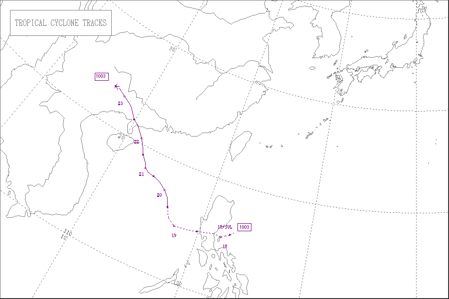
Early on July 17, the JMA reported that a tropical depression had developed about 220 km (135 mi) to the northeast of Manila, Philippines.[1] Later that day the JTWC reported that the depression had a small low level circulation center with deep convection flaring to the northeast of the center. However, as the low level circulation center was located close to land and was not very organized, the JTWC declared that there was a poor chance of it becoming a significant tropical cyclone within 48 hours. However, during that day, the depression rapidly consolidated with an anticyclone helping to develop the low level circulation center. As a result, early the next day the JTWC issued a tropical cyclone formation alert on the depression, however they thought that further development might be hindered as it was located close to land. Whilst it moved along the southern edge of the subtropical ridge, the Depression made landfall in Aurora province at 0600 UTC, before the JTWC initiated advisories later that morning, as the low level circulation center had consolidated and poleward outflow into the tropical upper tropospheric trough had improved. Late on July 19, PAGASA issued their last advisory on Tropical Storm Caloy as it had moved out of their Area of Responsibility Then, Chanthu began to head to China, where it peaked as a Category 1 hurricane. It made landfall on China and soon dissipated hours later.[2] Throughout Aurora, heavy rains triggered flash flooding which destroyed at least one home and stranded hundreds of residents. The Paltic barangay, within Dingalan, became inaccessible to rescuers after the local river topped its banks and washed out nearby slopes.[3] Following the system's development, PAGASA stated that rainfall from system could trigger landslides and flooding in Aurora, the Bicol Region, and Quezon.[4]
Impact[edit]
Philippines[edit]
In Luzon, heavy rains triggered floods that destroyed at least one house and stranded thousands of people. Eight people were killed in the Philippines.
China[edit]
In China, The Xinhua State news reported that two people were killed by walls that were blown over by strong gales. The typhoon made landfall near the city of Wuchuan. State-run television broadcast images of large waves crashing on to the Guangdong shore, trees flattened by wind and electric poles collapsed onto streets under heavy rain.[5] Thereafter heavy flooding swept away a 50-year-old man in a village in Hong Kong.[6] The southern Chinese provinces of Guangdong and Hainan braced themselves, ahead of Typhoon Chanthu's expected landfall. Guangdong meteorological authorities, have launched the highest level of disaster response.[7] In all, 9 people were killed in South China, and total economic losses were counted to be CNY 5.54 billion (US$817.7 million).[8]
Hong Kong[edit]
When Chanthu's rain bands passed over Hong Kong, heavy rains brought about serious floodings across the territory. The Black Rainstorm Signal was issued. Two people were drowned and found dead, and two are still missing.
See also[edit]
References[edit]
- ^ "JMA WWJP25 Advisory 2010-07-17 00z". Japan Meteorological Agency. 2010-07-17. Archived from the original on July 29, 2010. Retrieved 2010-07-17.
{{cite web}}: CS1 maint: unfit URL (link) - ^ Philippine Atmospheric, Geophysical and Astronomical Services Administration (2010-07-17). "Shallow Low Pressure Area Weather Advisory One" (PDF). National Disaster Coordinating Council. Retrieved 2010-07-17.
- ^ "Effects of Active Low Pressure Area in Aurora Province" (PDF). National Disaster Coordinating Council. 2010-07-18.
- ^ 2010 Pacific typhoon season.
- ^ Typhoon Chanthu lashes flood-hit China, July 22, 2010.
- ^ Typhoon Chanthu kills 3 becomes Tropical Storm heading North
- ^ Reporter: Impact of tropical storm Chanthu July 22, 2010
- ^ ""灿都"致3省9人死亡600万人受灾". 中国天气网. July 30, 2010.
External links[edit]
- JMA General Information of Typhoon Chanthu (1003) from Digital Typhoon
- The JMA's Best Track Data on Typhoon Chanthu (1003) (in Japanese)
- The JMA's RSMC Best Track Data (Graphics) on Typhoon Chanthu (1003)
- The JMA's RSMC Best Track Data (Text)
- The JTWC's Best Track Data on Typhoon 04W (Chanthu)
- 04W.CHANTHU from the U.S. Naval Research Laboratory
Tropical cyclones of the 2010 Pacific typhoon season | ||
|---|---|---|
 | ||