
User:Awtribute/boxofsand
History[edit]
In late 2006, work began on twinning a congested 14.5-mile (23.3 km) segment between Mabank and Athens; the portion from Eustace eastward was completed in 2009 and opened to traffic. The part between the Kaufman County line and Eustace is expected to be open by late December 2010, as an interchange is being constructed at SH 334. Future plans call for widening US 175 to four lanes in phases between Baxter and Frankston, and between Frankston and Jacksonville; these phases were originally scheduled to have begun construction already but plans have been delayed due to lack of funding.
Route description[edit]

Crandall and Kaufman. After passing through Kaufman, US 175 is no longer a freeway and continues as a divided highway. The highway bypasses Kemp to the east and passes near the north end of Cedar Creek Reservoir. East of the reservoir, the highway bypasses Mabank before merging into a 2-lane highway (though construction as of 2008 is underway to widen the road to a divided highway status). As it continues to the southeast, US 175 passes through Eustace on its way to Athens.

In Athens, US 175 passes around the city to the north and east (with Loop 7; multiplexing with parts of TX 19 and TX 31 while bypassing) while the old highway passes through the center as a business route. Outside the city limits the business and bypass sections rejoin, later passing through the cities of Poynor, Frankston and Cuney before reaching Jacksonville, where it reaches its eastern terminus at US 69.[1]
Dallas County[edit]
US 175 begins south of downtown Dallas at an interchange with I-45 south of I-30, South Central Expressway, and Good-Latimer Expressway. The highway heads towards the southeast as a freeway carrying the dual monikers of South Central Expressway and S.M. Wright Freeway (the latter named for a local minister and community leader in South Dallas).
At an interchange with SH 310 (known locally as Dead Man's Curve because of the 90-degree angle turn of the freeway at that point), US 175 begins to head to the east (taking the name C.F. Hawn Freeway, named after an Athens businessman who served as Texas Highway commissioner) while the South Central Expressway and S.M. Wright Freeway names follow SH 310. The freeway, now 3 lanes in each direction, continues east along the north edge of Rochester Park until it turns back to the southeast at an interchange at 2nd Avenue (a previous routing of US 175); from this point US 175 maintains a consistent southeasterly direction.
US 175 passes through the Pleasant Grove area of Dallas past an interchange with Loop 12 (N. Buckner Blvd.) and a few miles later, intersects I-20 just southwest of the I-20 and I-635 interchange/split. The highway continues as a freeway past the I-20 interchange, having narrowed to 2 lanes each direction, while passing briefing in and out of the town of Balch Springs. After the exit for Woody Road, US 175 leaves Dallas and enters Seagoville.
Kaufman County[edit]
The US 175 freeway section continues after the county line, but surroundings become more rural and less urban. After an interchange with FM 1389, the freeway goes through a low valley area which includes a crossing of the East Fork of the Trinity River. After the river bridge, US 175 enters Crandall. As the freeway leaves the valley, it passes an interchange with FM 741. Afterward, the main part of Crandall can be seen along the freeway. Before leaving, there is an interchange with FM 148. Upon exiting Crandall, farms and rural homes can be seen alongside US 175. A few miles later is an interchange with FM 1390, followed shortly by an interchange with FM 2578. At this point US 175 enters the city limits of Kaufman. A mile or so later, there is a T-shaped interchange with SH 243, which serves the downtown portion of Kaufman, while US 175 continues as a freeway around the center of town. The next 2 interchanges are spaced close together, FM 1388 (which goes south to Oak Grove, a Kaufman suburb), then SH 34 (which connects to Terrell and Ennis). About a mile after the SH 34 interchange, after an exit to the freeway frontage road, US 175 transitions from a freeway to a 4-lane divided highway with at-grade intersections and crossovers. After several miles of rural homes and farms, US 175 intersects FM 2860. About 2 miles further, comes the city limits of Kemp; a few local businesses line this area. Another mile or so brings the turnoff of a Business Route of US 175, which goes into the downtown section of Kemp, while the main US 175 highway continues east and around town.
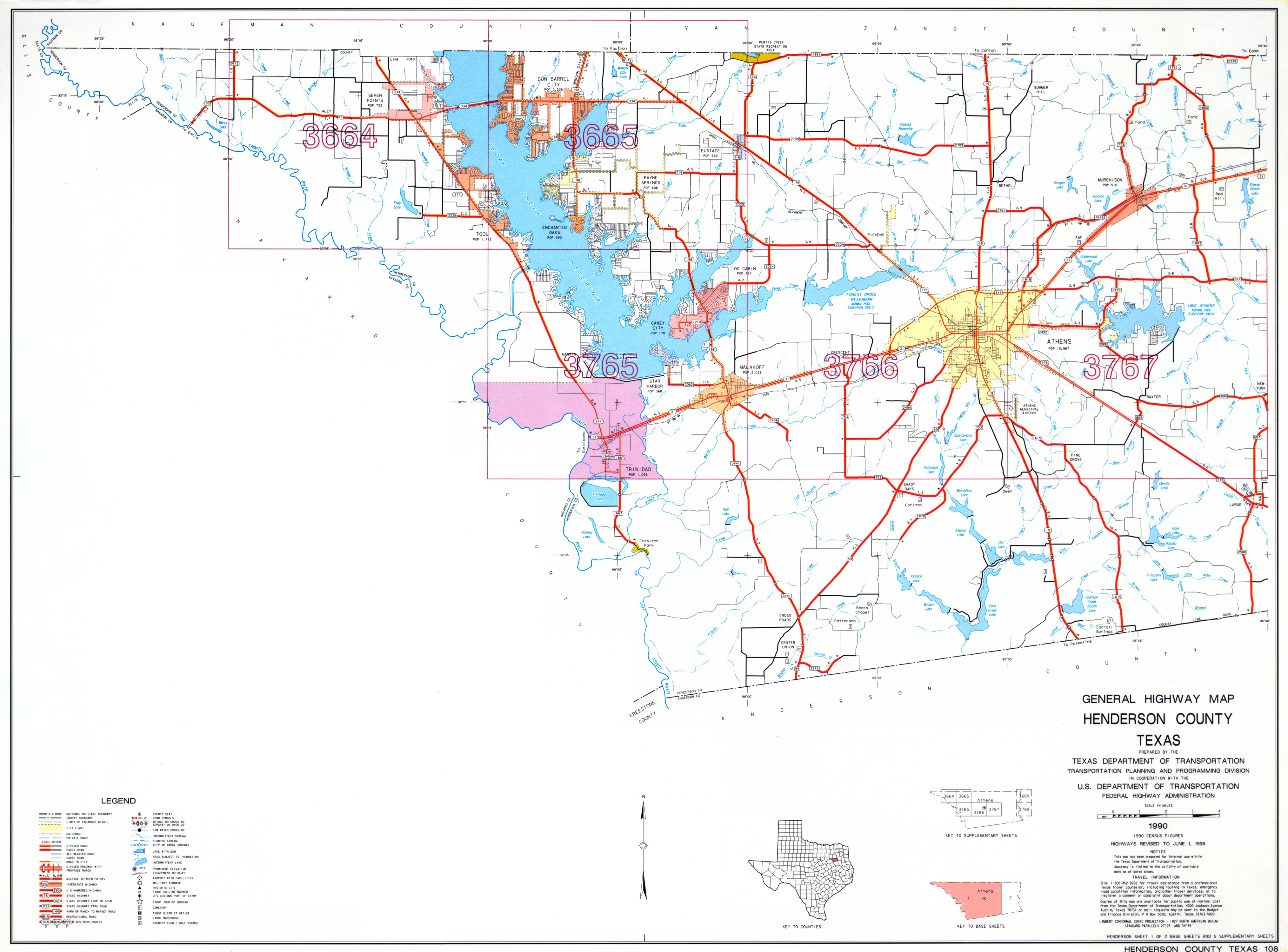
Henderson County[edit]
Anderson County[edit]
After miles and miles of narrow pavement, US 175's 2 lanes get a little wider after entering Anderson County, plus shoulders start to be seen on both sides of the highway. The road encounters some slight short hills, while alongside, groves of trees and small clearings and ranches can be seen. Three county road turnoffs to the north pass, then the Frankston city limit sign can be seen. Speed limits start to decrease here also.
Cherokee County[edit]
After crossing the narrow bridge over the Neches River, US 175 continues as a 2-lane road with shoulders. After a short hill, the road crosses the city limit of Cuney. The speed limit decreases, and there are several county roads (no named streets or numbered highways) that cross US 175 at different angles. It is best to watch for pedestrians trying to cross the highway here, as well. There are no services except for gas pumps at one of the city's liquor stores. About .25 miles (0.40 km) after leaving the city limits, FM 855 intersects from the north (even though the road is signed west/east); FM 855 must stop for US 175's through traffic. This Farm to Market road connects this part of US 175 to the east shore of Lake Palestine and the community of Mount Selman. Around a curve past FM 855, the highway comes upon the Reese community, and a cemetery on each side of the road. Reese has no services or numbered roads, just a few county road intersections in between quaint homes and farms. Another curve leads US 175 out of Reese and to the beginning of a long incline. A climbing lane starts about .50 miles (0.80 km) east of Reese, and lasts for about 1.5 miles (2.4 km). At the top of the hill, scenic vistas looking east, south, and west can be seen as the highway enters the community of Cove Springs. As with Reese, Cove Springs is without services, but is dotted with rural homes and farms in between a few county road intersections. When US 175 leaves Cove Springs, a downward slope begins with a climbing lane for westbound traffic. A broad view of the eastern horizon can be seen, including parts of Jacksonville, several miles ahead. At the bottom of the slope, the terrain has more short hills, some have climbing lanes for traffic on US 175 going in either direction. A few more county road intersections later, 1 turns north, where a sign points the way to the Killough Monument, site of one of the largest attacks by Native Americans to ever take place in east Texas. That county road is actually part of the Neches Saline Road, an early trail connecting a fort outside Nacogdoches with a point along the Neches River in northwest Cherokee County where salt was extracted and used by early settlers. The site is now beneath the waters of Lake Palestine, and the Neches Saline Road is the subject of a Texas Historical Marker found across US 175 from the turnoff of the road (the south side of the highway). The next county road off of US 175 leads to the Lakeview community (not marked) and is the path of a previous state highway that led into Jacksonville (pre-1932, when US 175 was commissioned) from the northwest. A few more short hills later, the highway levels off and the Jacksonville city limit sign can be seen. Starting there, US 175 also uses 1 of 2 in-town street names, Frankston Street. A slight curve to the left afterward, then the first street intersection comes along--Pineda Street to the right and a county road (the locals also call it 'Tol Smith Road') to the left. The first of 2 gas stations can be found on the southeast corner. Less than .25 miles (0.40 km) later, there are bare silver abutments on each side of US 175. This was the site of a Cotton Belt railroad overpass that measured just over 14 feet (4.3 m) high, which was sometimes a barrier for those driving tall trucks. The overpass was removed after the railroad was abandoned in the mid-1980s. Another slight rise along the highway, coinciding with the first speed limit decrease inside Jacksonville, comes along, and the urban portion of the city can begin to be seen. Three street intersections pass before the first one with a traffic signal, North Bolton Street, is encountered. North Bolton is also signed FM 347; the crossing is not signed well for those on US 175. This intersection is the site of the second gas station, on the southwest corner. At this point, the highway widens to 4 lanes with a left turn, the surface changes to concrete, and the street name changes to Alexander Blvd., to honor a local former City Councilman who lives nearby that helped in the effort to relieve US 175 of a decades-old zigzag path into downtown. Since 2002, US 175 has traveled the straightened Alexander Blvd. east of North Bolton. The east terminus at US 69 is now in sight. In between, 1 final street crosses the highway, then a traffic light ahead brings the path of US 175 to a stop. Signage is incomplete at this intersection, including no guide signage listing any of the control cities in any of the 3 directions, and no reassurance signage can be found in any of the directions labeling which of the 2 US highways (and their corresponding directions) lead drivers away from the intersection. A left on US 69 (which is also North Jackson Street here) goes north toward Tyler, while a right turn is the way to downtown Jacksonville, as well as Rusk and Lufkin, further south.
Exit / junction list[edit]
| County | Location | Destinations | Notes |
|---|---|---|---|
| Dallas | Dallas | Northbound exit and southbound entrance West terminus | |
| Central Expressway, Good-Latimer Expressway | Northbound exit and southbound entrance | ||
| Martin Luther King, Jr. Boulevard | |||
| Pennsylvania Avenue | Westbound exit and eastbound entrance | ||
| Metropolitan Avenue | |||
| Pine Street | |||
| Hatcher Street | |||
| No westbound exit | |||
| Bexar Street | No eastbound entrance | ||
| Railroad Avenue | Westbound exit and eastbound entrance | ||
| Municipal Street | Eastbound exit and entrance | ||
| 2nd Avenue, Bruton Road | |||
| Lake June Road | |||
| Frontage Road | Eastbound exit and westbound entrance | ||
| Jim Miller Road | Westbound exit is via the Elam Road exit | ||
| Elam Road | |||
| Frontage Road | |||
| St. Augustine Road | |||
| Masters Drive | |||
| Haymarket Road, Kleberg Road | No eastbound entrance | ||
| Silverado Drive | |||
| Edd Road | |||
| Belt Line Road | |||
| Woody Road | Westbound exit is via the Stark Road exit | ||
| Seagoville | Stark Road | ||
| Simonds Road, Kimberly Drive | |||
| Seagoville Road, Kaufman Street | |||
| Hall Street | |||
| Malloy Bridge Road | |||
| Kaufman | |||
| Crandall | |||
| County Road | |||
| Kaufman | |||
| Frontage Road | |||
| No eastbound entrance | |||
| No eastbound entrance | |||
| No westbound entrance | |||
| Frontage Road | Freeway ends Divided 4-lane begins | ||
| Fair Road | |||
| Jiba Road | |||
| Kemp | |||
| Interchange | |||
| Mabank | |||
| Interchange | |||
| Henderson | |||
| Gun Barrel City | Interchange (under construction) | ||
| Eustace | Divided 4-lane ends 4-lane with left turn begins | ||
| West end of FM 316 overlap (signaled intersection) | |||
| East end of FM 316 overlap (signaled intersection) | |||
| 4-lane with left turn ends Divided 4-lane begins | |||
| Athens | Interchange; west end of SH 31/Loop 7 overlap Divided 4-lane ends before interchange 4-lane with left turn begins before interchange (requires at-grade turn) | ||
| Interchange; west end of SH 19 overlap | |||
| Interchange; east end of SH 31 overlap | |||
| Interchange | |||
| Interchange; east end of SH 19/Loop 7 overlap 4-lane with left turn ends at interchange Divided 4-lane begins after interchange (requires at-grade turn) | |||
| Baxter | Divided 4-lane ends 2-lane road begins | ||
| LaRue | (signed with | ||
| (signed with | |||
| Poynor | (flashing yellow/red at intersection) | ||
| Anderson | Frankston | 2-lane road ends inside city limits 4-lane road begins | |
| Left turn lane 1 block east and west of SH 155 (signaled intersection) | |||
| 4-lane road ends before city limits 2-lane road begins | |||
| Cherokee | Cuney | only local/county road intersections | |
| Reese | only local/county road intersections | ||
| Cove Springs | only local/county road intersections | ||
| Jacksonville | 2-lane road ends 4-lane with left turn begins (signaled intersection) | ||
| (signaled intersection) East terminus |
The following is a list of all state highways in Henderson County, Texas maintained by the Texas Department of Transportation. All state highways in Texas are paved.
U.S. Highways[edit]
| Route Name | Direction | Termini | Junctions | Length[2][3] | Remarks |
|---|---|---|---|---|---|
| W/E | Kaufman County to Anderson County | |
(1st US 175 business route is suffixed "E", the 2nd/3rd are suffixed "G") |
State Highways[edit]
| Route Name | Direction | Termini | Junctions | Length[2][3] | Remarks |
|---|---|---|---|---|---|
| S/N | Anderson County to Van Zandt County | FM 1615,
|
The SH 19 Business route is suffixed "J" | ||
| W/E | Navarro County to Smith County |
|
The SH 31 Business route is suffixed "H" | ||
| S/N | Anderson County to Smith County | ||||
| S/N | |||||
| S/N | |||||
| W/E |
|
SH 334 was previously a part of FM 85 |
State Highway Loops and Spurs[edit]
| Route Name' | Direction | Termini | Junctions | Length[2][3] | Remarks |
|---|---|---|---|---|---|
|
|||||
Farm and Ranch to Market Roads[edit]
Historic roads[edit]
| Route Name | Direction | Termini | Junctions | Length | Remarks |
|---|
Adjacent counties[edit]
- Van Zandt County (north)
- Smith County (east)
- Cherokee County (southeast)
- Anderson County (south)
- Navarro County (southwest)
- Ellis County (west)
- Kaufman County (northwest)
References[edit]
- ^ Google (2008-03-02). "overview map of US 175" (Map). Google Maps. Google. Retrieved 2008-03-02.
- ^ a b c d Texas Department of Transportation, - Henderson County map #1
- ^ a b c d Texas Department of Transportation, - Henderson County map #2
- ^ Transportation Planning and Programming Division (n.d.). "U.S. Highway No. 175". Highway Designation Files. Texas Department of Transportation.
- ^ Transportation Planning and Programming Division (n.d.). "State Highway No. 19". Highway Designation Files. Texas Department of Transportation.
- ^ Transportation Planning and Programming Division (n.d.). "State Highway No. 31". Highway Designation Files. Texas Department of Transportation.
- ^ Transportation Planning and Programming Division (n.d.). "State Highway No. 155". Highway Designation Files. Texas Department of Transportation.
- ^ Transportation Planning and Programming Division (n.d.). "State Highway No. 198". Highway Designation Files. Texas Department of Transportation.
- ^ Transportation Planning and Programming Division (n.d.). "State Highway No. 274". Highway Designation Files. Texas Department of Transportation.
- ^ Transportation Planning and Programming Division (n.d.). "State Highway No. 334". Highway Designation Files. Texas Department of Transportation.
- ^ Transportation Planning and Programming Division (n.d.). "State Highway Loop No. 7". Highway Designation Files. Texas Department of Transportation.
- ^ Transportation Planning and Programming Division (n.d.). "State Highway Loop No. 60". Highway Designation Files. Texas Department of Transportation.
- ^ Transportation Planning and Programming Division (n.d.). "Farm to Market Road No. 59". Highway Designation Files. Texas Department of Transportation.
- ^ Transportation Planning and Programming Division (n.d.). "Farm to Market Road No. 85". Highway Designation Files. Texas Department of Transportation.
- ^ Transportation Planning and Programming Division (n.d.). "Farm to Market Road No. 314". Highway Designation Files. Texas Department of Transportation.
- ^ Transportation Planning and Programming Division (n.d.). "Farm to Market Road No. 315". Highway Designation Files. Texas Department of Transportation.
- ^ Transportation Planning and Programming Division (n.d.). "Farm to Market Road No. 316". Highway Designation Files. Texas Department of Transportation.
- ^ Transportation Planning and Programming Division (n.d.). "Farm to Market Road No. 317". Highway Designation Files. Texas Department of Transportation.
- ^ Transportation Planning and Programming Division (n.d.). "Farm to Market Road No. 607". Highway Designation Files. Texas Department of Transportation.
- ^ Transportation Planning and Programming Division (n.d.). "Farm to Market Road No. 753". Highway Designation Files. Texas Department of Transportation.
- ^ Transportation Planning and Programming Division (n.d.). "Farm to Market Road No. 764". Highway Designation Files. Texas Department of Transportation.
- ^ Transportation Planning and Programming Division (n.d.). "Farm to Market Road No. 773". Highway Designation Files. Texas Department of Transportation.
- ^ Transportation Planning and Programming Division (n.d.). "Farm to Market Road No. 804". Highway Designation Files. Texas Department of Transportation.
- ^ Transportation Planning and Programming Division (n.d.). "Farm to Market Road No. 1214". Highway Designation Files. Texas Department of Transportation.
- ^ Transportation Planning and Programming Division (n.d.). "Farm to Market Road No. 1305". Highway Designation Files. Texas Department of Transportation.
- ^ Transportation Planning and Programming Division (n.d.). "Farm to Market Road No. 1615". Highway Designation Files. Texas Department of Transportation.
- ^ Transportation Planning and Programming Division (n.d.). "Farm to Market Road No. 1616". Highway Designation Files. Texas Department of Transportation.
- ^ Transportation Planning and Programming Division (n.d.). "Farm to Market Road No. 1667". Highway Designation Files. Texas Department of Transportation.
- ^ Transportation Planning and Programming Division (n.d.). "Farm to Market Road No. 1803". Highway Designation Files. Texas Department of Transportation.
- ^ Transportation Planning and Programming Division (n.d.). "Farm to Market Road No. 1861". Highway Designation Files. Texas Department of Transportation.
- ^ Transportation Planning and Programming Division (n.d.). "Farm to Market Road No. 2010". Highway Designation Files. Texas Department of Transportation.
- ^ Transportation Planning and Programming Division (n.d.). "Farm to Market Road No. 2215". Highway Designation Files. Texas Department of Transportation.
- ^ Transportation Planning and Programming Division (n.d.). "Farm to Market Road No. 2329". Highway Designation Files. Texas Department of Transportation.
- ^ Transportation Planning and Programming Division (n.d.). "Farm to Market Road No. 2494". Highway Designation Files. Texas Department of Transportation.
- ^ Transportation Planning and Programming Division (n.d.). "Farm to Market Road No. 2495". Highway Designation Files. Texas Department of Transportation.
- ^ Transportation Planning and Programming Division (n.d.). "Ranch to Market Road No. 2588". Highway Designation Files. Texas Department of Transportation.
- ^ Transportation Planning and Programming Division (n.d.). "Farm to Market Road No. 2613". Highway Designation Files. Texas Department of Transportation.
- ^ Transportation Planning and Programming Division (n.d.). "Farm to Market Road No. 2636". Highway Designation Files. Texas Department of Transportation.
- ^ Transportation Planning and Programming Division (n.d.). "Farm to Market Road No. 2709". Highway Designation Files. Texas Department of Transportation.
- ^ Transportation Planning and Programming Division (n.d.). "Farm to Market Road No. 2752". Highway Designation Files. Texas Department of Transportation.
- ^ Transportation Planning and Programming Division (n.d.). "Farm to Market Road No. 2892". Highway Designation Files. Texas Department of Transportation.
- ^ Transportation Planning and Programming Division (n.d.). "Farm to Market Road No. 2970". Highway Designation Files. Texas Department of Transportation.
- ^ Transportation Planning and Programming Division (n.d.). "Farm to Market Road No. 3054". Highway Designation Files. Texas Department of Transportation.
- ^ Transportation Planning and Programming Division (n.d.). "Farm to Market Road No. 3062". Highway Designation Files. Texas Department of Transportation.
- ^ Transportation Planning and Programming Division (n.d.). "Farm to Market Road No. 3079". Highway Designation Files. Texas Department of Transportation.
- ^ Transportation Planning and Programming Division (n.d.). "Farm to Market Road No. 3204". Highway Designation Files. Texas Department of Transportation.
- ^ Transportation Planning and Programming Division (n.d.). "Farm to Market Road No. 3225". Highway Designation Files. Texas Department of Transportation.
- ^ Transportation Planning and Programming Division (n.d.). "Farm to Market Road No. 3273". Highway Designation Files. Texas Department of Transportation.
- ^ Transportation Planning and Programming Division (n.d.). "Farm to Market Road No. 3441". Highway Designation Files. Texas Department of Transportation.
- ^ Transportation Planning and Programming Division (n.d.). "Farm to Market Road No. 3506". Highway Designation Files. Texas Department of Transportation.
Business routes[edit]

SH 114 has four current business routes.
Business State Highway 114-B (formerly Loop 44) is a Business Loop that runs from SH 114 on the west side of Levelland (in west Texas) south along West Street, then east through the downtown area on Houston Street to an intersection with US 385 (College Street). The road turns left (north), concurrent with US 385, until intersecting once again at SH 114. The road was designated as Business SH 114-B in 1993, and is 1.594 miles (2.565 km) long.[1][2]
Business State Highway 114-J (formerly Spur 440) is a Business Spur that goes east into Rhome from the intersection of US 81/US 287 and SH 114 west. The route runs along Rhome Avenue to an intersection with Business US 81-E. It is part of a previous route of SH 114. The Business route was created in 1991 and is 0.329 miles (0.529 km) long.[3][4]
Business State Highway 114-K is a business loop that runs through Roanoke. This route runs on Byron Nelson Boulevard, along a previous route of SH 114. The business route was created in 2001 when SH 114 was rerouted further north and east around town. The route is 1.787 miles (2.876 km) long.[5]
Business State Highway 114-L (formerly Loop 382 as well as a previous routing of SH 114) is a business loop that runs through Grapevine. This route runs east on Northwest Highway to an intersection with Texan Trail, then turns right to go southbound there. The road continues until it reaches SH 114/SH 121. The portion of the business route along Texan Trail is concurrent with SH 26. The route was created in 1991 when the road's designation as Loop 382 was discontinued. The route is 2.074 miles (3.338 km) long.[6][7]
Former Business routes[edit]
There is one former Business Route along SH 114. Business State Highway 114-H was located in Bridgeport between 1991 and 2007 and was 1.3 miles (2.1 km) long. The route went east along Halsell Avenue from an intersection with SH 114, to an intersection with 13th Street, then turned right (south) until another intersection with SH 114. This route had been previously designated Loop 373 before 1991; since 2007, though, the portion along 13th was changed back to Loop 373.[8][9]
- ^ Texas Department of Transportation, Highway Designation File - State Highway Loop 44
- ^ Texas Department of Transportation, Highway Designation File - Business State Highway 114-B
- ^ Texas Department of Transportation,Highway Designation File - State Highway Spur 440
- ^ Texas Department of Transportation, Highway Designation File - Business State Highway 114-J
- ^ Texas Department of Transportation, Highway Designation File - Business State Highway 114-K
- ^ Texas Department of Transportation, Highway Designation File - State Highway Loop 382
- ^ Texas Department of Transportation, Highway Designation File - Business State Highway 114-L
- ^ Texas Department of Transportation, Highway Designation File - State Highway Loop 373
- ^ Texas Department of Transportation, Highway Designation File - Business State Highway 114-H