User:CROIX/St. John's rewrite
17°07′N 61°51′W / 17.117°N 61.850°W
City of St. John's
Sen Jaan | |
|---|---|
City | |
|
Top: St. John's skyline; Middle: Museum of Antigua and Barbuda, St. John's Harbour; Bottom: Fort James, St. John's Cathedral | |
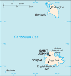
 Location of St. John's in Antigua and Barbuda | |
| Coordinates: 17°07′N 61°51′W / 17.117°N 61.850°W | |
| Country | |
| Island | Antigua |
| Parish | Saint John |
| Colonised | 1632 |
| Area | |
| • Total | 10 km2 (4 sq mi) |
| Elevation | 0–59 m (0–194 ft) |
| Population (2011) | |
| • Total | 22,219 |
| • Density | 3,100/km2 (8,000/sq mi) |
| Time zone | UTC-4 (AST) |
| Airport | V.C. Bird International Airport |
| Website | sjdcanu |
St. John's (Antiguan Creole: Sen Jaan), officially the City of St. John's, is the largest city in Antigua and Barbuda, and the capital of the parish of Saint John. It is on ten square kilometres of land on St. John's Harbour. As a primate city and major economic hub in the Leeward Islands, St. John's has been Antigua and Barbuda's economic, cultural, and political hub since its founding in the 1600s.


