canuckle - Cool dude of Canadian origin. Loves donuts (especially Tim Horton's), women and ice hockey. Not necessarily all at the same time, but it wouldn't hurt.
Man, that dude's a canuckle!
A witty wise-cracking on-line friend who supplies TH at all the right times.
When's that Canuckle gonna get here with my donuts?
8 July 2013 ... that a storm on Lucy Island unearthed 5,500-year-old remains of a woman whose DNA has been directly linked to a modern-day descendent, a Tsimshian woman living near Prince Rupert?
22 April 2011 .. that the flash of light accompanying an earthquake in 1896 was attributed by some residents of North Piddle, Worcestershire, to a large meteor?
2 July 2013 ... that leaving Mount Tzouhalem in search of a 15th wife led to the killing of the mountain's namesake?
John Rocque's maps of London were published in 1746. A French-born British surveyor and cartographer, John Rocque produced two maps of London and the surrounding area. The better known of these, depicted here, is a 24-sheet map of the City of London and the surrounding area, surveyed by Rocque and engraved by John Pine and titled A Plan of the Cities of London and Westminster, and Borough of Southwark. Rocque combined two surveying techniques: he made a ground-level survey with a compass and a physical metal chain – the unit of length also being the chain. Compass bearings were taken of the lines measured. He also created a triangulation network over the entire area to be covered by taking readings from church towers and similar high places using a theodolite made by Jonathan Sisson (the inventor of the telescopic-sighted theodolite) to measure the observed angle between two other prominent locations. The process was repeated from point to point. This image depicts all 24 sheets of Rocque's map.Map credit: John Rocque and John Pine


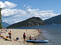 Copper Island in Shuswap Lake
 BC Ambulance at Royal Columbian Hospital Emergency department
 Lucy Island lighthouse (recrop) on home page for DYK
 An atypical white-furred Vancouver Island Wolf in captivity at the Greater Vancouver Zoo
 Stuart Island Airpark (foreground) lies on the western shore of Prevost Harbour across from Satellite Island (Washington)
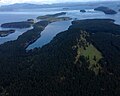 South-facing aerial view of Reid Harbour on Stuart Island, Washington in the Strait of Georgia
 'Infinite Tires' public art by Douglas Coupland in south Vancouver
 Pere David Deer resting at the Greater Vancouver Zoo
 East-facing aerial view of Westminster Highway and Canada Line overpass to Brighouse Station in Richmond, British Columbia
 South-facing aerial view of Saturna Island
 RCMP visiting Burnaby Hospital
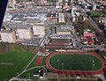 East-facing aerial view of Minoru Park
 North-facing aerial view of Dinsmore Bridge in Richmond, British Columbia connecting Lulu Island with Sea Island
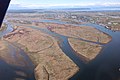 An east-facing aerial view of Ladner, British Columbia beyond Duck Island, Barber Island, Gunn Island and Port Guichon in the Fraser River Estuary
 A container ship loading up at Roberts Bank Superport


