User:GeogSage/sandbox

This user is a WikiDragon.
From Wikipedia, the free encyclopedia
Die Fliege

User Talk Wikipedia contributions Wikiquote Contributions Wikimedia Commons Contributions Guestbook

This is my "To do list" and "Scrap drawer" where I keep fragmented half baked ideas for articles and scraps. When I begin to focus on one more seriously, I move it to one of my other sandboxes.


Pages to create

Pages to create[edit]


  • Pages for The AAG Applied Geography Specialty Group James R. Anderson Medal of Honor winners
    • Budhendra "Budhu" Badhuri (2018)
    • William Derrenbacher (2015)
    • Jerome E. "Jerry" Dobson (2014)
    • Jeffrey Osleeb (2013)
    • Lee R. Schwartz (2012)
    • Robert B. Honea (2011)
    • Michael Sutcliffe (2007)
    • Marilyn A. Brown (2004)
    • Barry Wellar (2003)
    • Richard D. Wright (2002)
    • William B. Wood (2001)
    • Kingsley E. Haynes (2000)
    • Joel R. Morrison (1999)
    • Frank H. Thomas (1997)
    • John W. Frazier (1996)
The SAGE Handbook series

==List of Handbooks

Title Editor(s) Year Editions Ref
Early detection rapid response

[1] [2] [3] [4]

[5] [6]

Geographically Weighted Regression


The Geographically Weighted Regression (GWR) Family of Statistics is a collection of spatial statistical techniques that extend traditional regression methods by allowing for spatial variability in the relationships between dependent and independent variables. Where linear Ordinary least squares (OLS) regression assumes that the variables have a global relationship, GWR looks at local relationships between variables. This family of statistics is instrumental in spatial analysis, as it accounts for spatial heterogeneity and the influence of geographic location on statistical relationships.

GWR is built on. In OLS Regression, the formula is:

where , is a column vector of the -th observation of all the explanatory variables;

is a vector of unknown parameters;

and the scalar represents unobserved random variables (errors) of the -th observation.

accounts for the influences upon the responses from sources other than the explanatory variables .

Getis-Ord Gi


Getis-Ord Gi (also known as the Getis-Ord General G statistic) is a statistical method used to identify spatial clusters of high or low values in a spatial dataset. The method was developed by Arthur Getis and J. K. Ord in 1992.

The Gi statistic measures the degree of spatial autocorrelation of a variable in a set of neighboring locations. Spatial autocorrelation refers to the extent to which similar values tend to cluster together in space. The Gi statistic is calculated for each location in the dataset and can be used to identify clusters of high or low values and outliers.

The calculation of the Gi statistic involves three steps:

Calculate the local sum for each location. This involves adding up the variable values for the location and its neighboring locations.

Calculate the global sum and mean for the entire dataset. This involves adding up the variable values for all locations in the dataset and dividing by the total number of locations.

Calculate the standard deviation for the entire dataset.

The Gi statistic for each location is then calculated as follows:

Gi = (Xi - Xbar) / S * Σj(wij * Xj - Xbar)

where Xi is the value of the variable at location i, Xbar is the mean of the variable for the entire dataset, S is the standard deviation for the entire dataset, wij is a spatial weight that measures the distance between location i and j, and Xj is the value of the variable at location j.

A positive Gi value indicates that the location has a high value relative to its neighbors, while a negative Gi value indicates that the location has a low value relative to its neighbors. The magnitude of the Gi value indicates the strength of the spatial clustering.

The Gi statistic can be visualized using a map, with locations colored based on their Gi values. This can help identify the dataset's spatial clusters of high or low values. The Gi statistic is commonly used in geography, epidemiology, and environmental science to analyze spatial patterns in data.

Getis-Ord Gi*[edit]

Getis-Ord Gi* (pronounced "Getis-Ord G-star") is an extension of the Getis-Ord Gi statistic, which is used to identify statistically significant hotspots and coldspots in a spatial dataset. The method was developed by Arthur Getis and J. K. Ord in 1996 to improve the original Gi statistic.

The Gi* statistic is calculated using a similar formula to the Gi statistic but with an additional term that considers the spatial autocorrelation of the data at different distances. The formula for the Gi* statistic is:

Gi* = (Xi - Xbar) / S * Σj(wij * Xj - Xbar) / √(Σj(wij))^2 / N

where N is the total number of locations in the dataset.

The numerator of the Gi* formula is the same as the Gi formula. At the same time, the denominator represents a measure of the expected value of the sum of the weights for each location. The denominator considers the spatial autocorrelation of the data at different distances and is used to standardize the numerator.

The Gi* statistic produces a z-score, which can be used to determine the statistical significance of a hotspot or coldspot. A positive z-score indicates a statistically significant hotspot (i.e., a location with a high value surrounded by locations with high values), while a negative z-score indicates a statistically significant coldspot (i.e., a location with a low value surrounded by locations with low values).

The significance of the z-score can be determined using a p-value or a critical value. A p-value represents the probability of obtaining a z-score as extreme as the observed value, assuming that the null hypothesis (i.e., no spatial clustering) is true. A critical value represents the threshold above which the z-score is considered statistically significant.

The Gi* statistic can be used to identify hotspots and coldspots in various spatial datasets, such as crime data, disease incidence data, and environmental data. The method is particularly useful for identifying spatial patterns that may be missed by other methods and for generating hypotheses about the underlying causes of spatial clustering.

The laws of geography
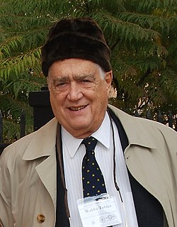
Waldo Tobler in front of the Newberry Library. Chicago, November 2007

The laws of geography are a set of scientific laws defining spatial data characteristics.

The concept of laws in geography is a product of the quantitative revolution and is a central focus of quantitative geography. Their emergence is highly influential and one of the major contributions of quantitative geography to the broader branch of technical geography.[7] The discipline of geography is unlikely to settle the matter anytime soon. Several laws have been proposed, and Tobler's first law of geography is the most widely accepted. The first law of geography, and its relation to spatial autocorrelation, is highly influential in the development of technical geography.[7]

Some have argued that geographic laws do not need to be numbered. The existence of a first invites a second, and many are proposed as that. It has also been proposed that Tobler's first law of geography should be moved to the second and replaced with another.[8] A few of the proposed laws of geography are below:

List of Laws in Geography[edit]

Law Name Law Author Year
Tobler's first law of geography[9][10] "Everything is related to everything else, but near things are more related than distant"Tobler, Waldo (2004). "On the First Law of Geography: A Reply". Annals of the Association of American Geographers. 94 (2): 304–310. doi:10.1111/j.1467-8306.2004.09402009.x. S2CID 33201684. Retrieved 10 March 2022.</ref>[8] Waldo Tobler 1970
Tobler's second law of geography[10] "the phenomenon external to a geographic area of interest affects what goes on inside." Waldo Tobler
Arbia's law of geography[10][11][12] U"Everything is related to everything else, but things observed at a coarse spatial resolution are more related than things observed at a finer resolution." Arbia 1996
  • :
  • :
  • :
  • Uncertainty principle: "that the geographic world is infinitely complex and that any representation must therefore contain elements of uncertainty, that many definitions used in acquiring geographic data contain elements of vagueness, and that it is impossible to measure location on the Earth's surface exactly."[8]
Terrain Ruggedness Index

The Terrain Ruggedness Index (TRI) is a quantitative measure used in geography and geomorphology to assess the roughness or ruggedness of a terrain surface. It is a tool commonly employed in fields such as hydrology, ecology, and geology to characterize landscapes and understand their influence on various processes and phenomena.

==Calculation The Terrain Ruggedness Index is typically computed using elevation data, such as digital elevation models (DEMs) derived from satellite imagery or ground-based surveys. The index is calculated based on the variability of elevation within a defined area, with higher values indicating greater ruggedness or roughness.

==Interpretation The Terrain Ruggedness Index provides a quantitative measure of the variability in terrain elevation within a specified area. Higher values of TRI indicate rougher or more rugged terrain, whereas lower values suggest smoother or flatter landscapes. This index is particularly useful in landscape analysis, ecological studies, and terrain modeling, where understanding terrain complexity is essential.


Riley et al. 1999 A terrain ruggedness index that quantifies topographic heterogeneity

https://livingatlas-dcdev.opendata.arcgis.com/content/28360713391948af9303c0aeabb45afd/about

John Nystuen
John Nystuen
Born(1931-01-07)7 January 1931
Northfield, Minnesota
Died2 July 2022(2022-07-02) (aged 91)
CitizenshipUnited States of America
Alma materUniversity of California, Berkeley, University of Washington
OccupationGeographer

John Nystuen (January 1, 1931 – July 7, 2022) was an American Geographer https://deepblue.lib.umich.edu/bitstream/handle/2027.42/175283/SolsticeVolumeXXXIIINumber2.pdf?sequence=1&isAllowed=y https://www.sierraclub.org/sites/default/files/2022-12/The%20Lookout%20Fall%202022%20Final.pdf http://faculty-history.dc.umich.edu/faculty/john-nystuen/memoir https://www.tandfonline.com/doi/pdf/10.1559/152304000783547867

Pradyumna Prasad Karan
Born(1930-09-31)31 September 1930
DiedError: Need valid birth date (second date): year, month, day
OccupationGeographer
Academic background
Alma materPatna University, Banaras Hindu University, Indiana University Bloomington
Academic work
DisciplineGeography
Sub-disciplinegeographic information science

Pradyumna Prasad Karan, also known as Paul, was an influential South Asian Geographer in the United States, focusing on environmental management and sustainable development in the non-western world.[13][14]

Education and field[edit]

Career[edit]

Publications[edit]

Awards[edit]

See also[edit]

References[edit]

  1. ^ "Early Detection and Rapid Response". U.S. Department of the Interior. Retrieved 12 April 2024.
  2. ^ "Early Detection and Rapid Response". United States Geological Survey. Retrieved 12 April 2024.
  3. ^ "Early Detection and Rapid Response". Aquatic Nuisance Species Task Force. U.S. Fish & Wildlife Service. Retrieved 12 April 2024.
  4. ^ "Early Detection and Rapid Response". National Invasive Species Information Center. U.S. Department of Agriculture. Retrieved 12 April 2024.
  5. ^ Reaser, Jamie K.; Burgiel, Stanley W.; Kirkey, Jason; Brantley, Kelsey A.; Veatch, Sarah D.; Burgos-Rodríguez, Jhoset (31 December 2019). "The early detection of and rapid response (EDRR) to invasive species: a conceptual framework and federal capacities assessment". Biological Invasions. 22: 1–19. doi:10.1007/s10530-019-02156-w. Retrieved 12 April 2024.
  6. ^ Adams, Aaron (2021). "Treating Invasive Tamarisk as an Intern at San Andres National Wildlife Refuge" (PDF). The Geographical Bulletin. 62 (2): 101–103. Retrieved 11 July 2023.
  7. ^ a b Haidu, Ionel (2016). "What is Technical Geography – a letter from the editor". Geographia Technica. 11: 1–5. doi:10.21163/GT_2016.111.01.
  8. ^ a b c Goodchild, Michael (2004). "The Validity and Usefulness of Laws in Geographic Information Science and Geography". Annals of the Association of American Geographers. 94 (2): 300–303. doi:10.1111/j.1467-8306.2004.09402008.x. S2CID 17912938.
  9. ^ Cite error: The named reference Tobler1 was invoked but never defined (see the help page).
  10. ^ a b c Cite error: The named reference Tobler3 was invoked but never defined (see the help page).
  11. ^ Arbia, Giuseppe; Benedetti, R.; Espa, G. (1996). ""Effects of MAUP on image classification"". Journal of Geographical Systems. 3: 123–141.
  12. ^ Smith, Peter (2005). "The laws of geography". Teaching Geography. 30 (3): 150.
  13. ^ Thakur, Rajiv R. (2019). "Obituary: Pradyumna Prasad Karan (1930–2018)". HIMALAYA. 39 (1). Retrieved 13 January 2024.
  14. ^ Metz, John J. (November 2021). "View of Pradyumna Prasad Karan (1930–2018)". HIMALAYA. 40 (2): 155–158. doi:10.2218/himalaya.2021.6586.

External links[edit]

taskforce template


{{Wikipedia:{{{projectname1}}}/Navigation}} Welcome to the {{{taskforce}}} task force of [[Wikipedia:{{{projectname1}}}|{{{projectname1}}}]].

Scope[edit]

  • {{{taskforce}}} covers...

Participants[edit]

  1. Example (talk · contribs)

Todo[edit]

Todo items for members of {{{taskforce}}} task force[edit]

  • Tag related articles.
  • Find editors who have shown interest in this subject and ask them to take a look here.
  • Identify articles for creation
  • Identify articles for improvement
  • Review importance and quality of existing articles

Todo items for anyone[edit]

{{Wikipedia:{{{projectname1}}}/{{{taskforce}}}/to_do}}

Guidelines[edit]

Tagging and assessment[edit]

Any articles that are within the scope of this project should be tagged with the project banners of [[Wikipedia:{{{projectname1}}}|{{{projectname1}}}]]. You may also find {{WikiProject banner shell}} useful. To each of these banners, you should add {{{taskforce-label}}}-task-force = yes as this will automatically put the page in the appropriate categories., such as [[:Category:{{{taskforce}}} task force articles]].

Categories[edit]

Templates[edit]

For main project templates, see the main project page for [[Wikipedia:{{{projectname1}}}|{{{projectname1}}}]].

Userbox template[edit]

{{[[Wikipedia:{{{projectname1}}}/Outreach/User {{{taskforce}}} task force]]}}

Infobox template[edit]

Stub templates[edit]

Featured/Good content[edit]

Resources[edit]


Wikilinks

Wikilinks[edit]

Misc.

Misc.[edit]

Uh-huh
Do NOT click on the red button.
Text