
User:Gurnard/QBEX
| File:QBEX logo.jpg QBEX logo | |
| Field | |
|---|---|
| Marine Research | |
| Funding | NERC / DEFRA |
| Partners | MBA, Cefas, Universities of Exeter, Plymouth Heriott-Watt and PML |
| Website | |
QBEX is a Natural Environment Research Council (NERC) and Department for Environment, Food and Rural Affairs (DEFRA) funded project bringing together scientists from the Marine Biological Association of the United Kingdom (MBA), the Centre for Environment, Fisheries and Aquaculture Science (CEFAS), the Universities of University of Exeter, Cornwall Campus, University of Plymouth, Heriott-Watt, International Centre for Island Technology, (Orkney Campus) and Plymouth Marine Laboratory (PML). It is one of four NERC/DEFRA funded Marine Renewable Energy Projects through the NERC Marine Renewable Energy Knowledge Exchange Programme.
Overview[edit]
The project addresses the extent to which the ‘spillover’ of bioresource abundance (species of commercial, ecological and conservation importance) as a consequence of protected area (non-fishing) status of Marine Renewable Energy Installations (MREIs) enhance adjacent areas.


Rationale[edit]
Tidal, wave and offshore wind resources will be important for meeting an increasing proportion of society's future energy needs. The UK Government is committed to developing capability and capacity in marine renewables, for example through its UK Low Carbon Transition Plan[1] pledging a 34% cut in emissions by 2020, (EU, 2009)[2]. Around £450 million will be spent on renewable and clean energy, helping to generate 2 GW of installed capacity in marine renewable energy by 2020.
Marine renewable energy devices are likely to have direct and indirect impacts on shelf and coastal environments and biota across a range of spatio-temporal scales. These potential effects (both positive and negative) have implications for pelagic, demersal and benthic fish and invertebrate populations, their essential (fish) habitats and the fisheries they support. The latter has particular importance since human food supply from fisheries (proteins derived from fish, crustaceans and molluscs) presently accounts for between 13.8 and 16.5% of the animal protein intake of human populations worldwide. Globally, there is at present a very limited understanding of how large-scale development of marine renewable energy installations (MREI) will affect fish and shellfish populations and the fisheries that exploit them, and indeed how any observed impacts may influence national legislation.
Populations of fish have complex spatial and temporal dynamics characterised by daily and seasonal migrations, regional differences in behaviour, distinct habitat preferences leading to philopatry, and age and sexual segregation. Commercially important invertebrates such as large crustaceans (e.g. brown crabs, lobster) have similarly complex spatial population dynamics, including seasonal migration and periods of crypsis (burial in the substratum), in addition to displaying extreme site fidelity in certain habitats. The processes structuring natural fish and shellfish populations are not well known, even though a responsive management framework requires defined ecologically coherent management units that represent the scales over which actual populations operate. An emerging issue in understanding fish and shellfish spatial dynamics and ecology is how and why they select particular habitats at certain times, and linked to this is how human-made devices in the marine environment, such as MREIs, may modify space use compared to adjacent areas.
Environmental effects of MREIs may include habitat change, changes in large-scale circulation patterns, increased [Turbidity|water turbidity]] and contaminant remobilisation during construction and decommission, increased habitat heterogeneity, noise, vibration and electromagnetic fields during operation. Further, because many fishers are unable to utilize areas occupied by MREIs or because certain fishing gears have to be excluded for operational reasons, it may be possible to create no-take zones to coincide with an MREI footprint especially where there are likely to be benefits for fisheries in adjacent waters. Whilst some research to date has considered fish sensory responses to probable
noise and electromagnetic fields associated with MREIs, the major gaps in knowledge that will have particular socio-economic importance lie in understanding the longer term behavioural and ecological responses, including habitat use by fish and shellfish, arising from marine renewable devices themselves and the areas immediately surrounding areas that exclude fishing. Where establishment of no-take areas is being considered in association with a MREI, e.g. through the Marine Conservation Zone network [3][4][5]from 2012, such effects of MREIs on fish and fisheries need to be investigated quantitatively.
These include the need to:
- Determine whether fisheries in areas adjacent to fishery exclusion zones around MREI sites in temperate regions are enhanced by the hypothesised biological ‘spillover’ effect, and the need to quantify the temporal stability of any such effect.
- Examine how areas occupied by MREIs may be connected biologically, e.g. Fernández et al., (2008) [6] at larger (regional/inter-regional) scales through highly mobile species. More broadly, the metapopulation dynamics of these protected areas as sources and sinks for marine animal population abundance need to be determined.
- Quantify the biological effects on fish and shellfish populations of displacing exploitation pressure from MREI sites to adjacent areas, alongside the associated social and economic costs and benefits for human fishers.
There is a paucity of data on the specific effects of MREIs on fish, shellfish and macrofauna behaviour in the natural environment, although likely influences can be inferred from studies of fish movements around other human-made and natural structures underwater. Aggregations of fishes form around solid structures deposited in the sea (c.f. fish aggregation devices)and it has been demonstrated that increasing the size, complexity and biofouling of the objects, supports greater numbers of increasingly large fish (Leitão et al., 2009) [7]. However, answering the question about whether the ‘reef’ merely attracts free-swimming biomass from elsewhere or enables greater productivity remains difficult to assess (Bohnsack et al., 1994 [8];
Grossmanet al., 1997)
and it has been argued that artificial concentrations of fish abundance may even act to increase both predation and fishing pressure on a stock. The perception that artificial reefs such as MREIs will generate additional stocks of commercially targeted species may not always be justified, and may depend in large part on the behavioural characteristics of the species in question
(Rodriguez-Cabelloet al., 2008)
and ‘opportunities’ the MREIs provide
(Langhamer & Wilhelmsson, 2009)
. Information on the behaviour of fishers displaced from MREIs is patchy with some studies suggesting that r edirected fishing effort from MREIs will do more harm than good since displaced fishingeffort will be expended on areas not usually fished
(Dinmoreet al., 2003).
Aims and objectives[edit]
The principal aim of QBEX is to quantify the extent to which ‘spillover’ of bioresource abundance (fish and invertebrate species) enhances adjacent areas as a consequence of fishing exclusions within and around Marine Renewable Energy Installations (MREIs)[9]. The focus is to use novel technologies for determining the spatial movements of fish and shellfish across a wide range of spatio-temporal scales (spanning metres to 100s of kilometres, and minutes to years). Space use will be related quantitatively to the changing physical and biological environment and will inform an understanding of the effects of fish spatial dynamics on field monitoring-derived estimates of abundance of fish and macroinvertebrates comprising the community assemblage found within and adjacent to MREI sites. The social and economic costs of MREIs on fisheries will also be assessed, which together with the novel combination of tracking technologies and environmental sampling will allow the first test of the importance of potential spillover to regions adjacent to MREIs.
The specific objectives are:
- To quantify the spatio-temporal change in distribution and abundance of commercial species (e.g. thornback (Raja clavata) and blonde ray (Raja brachyura), and edible crab using novel methodologies, and in relation to environment (waves, current, noise mapping) and potential predators (seabirds and marine mammals).
- To determine and value any spillover effect of bioresource abundance from Marine Renewable sites to adjacent areas.
- To identify the extent to which changes represent spatial re-distribution or increased abundance, and role of within-species size interactions.
Modules[edit]
The aims and objectives are being met by 5 modules across the partner organisations.
Module 1. Animal movements (Partners participating: MBA, Cefas, Exeter)
Module 2. Animal distribution and abundance (Exeter, MBA, Cefas)
Module 3. Integration of animal movements with physical characterisation (MBA, Exeter, Cefas, Plymouth, ICIT)
Module 4. Estimating ‘spillover’ from spatial dynamics and abundance and its effects on fisheries (MBA, Exeter, Cefas, ICIT)
Module 5. Determining the social and economic costs and benefits of ‘spillover’ from MREIs to inform marine spatial planning decisions PML
Module 1. Animal movements[edit]
The spatial movements and distribution of individuals of key species is being tracked through time at each of the two sites using novel technology and methods. The purpose is to quantify the movements and space use of a high number of individuals of each study species over periods as long as several years to be able to determine spatial re-distributions over similar temporal scales in relation to space within and adjacent to the MREI that exclude or limit fishing activity. Species to be studied in detail will be relevant to site. We are focusing on two commercially important species per site, for example candidate species include brown crab (Cancer pagurus), Atlantic cod (Gadus morhua), plaice (Pleuronectes platessa), thornback ray (Raja clavata) or blonde ray (Raja brachyura).
Space use of individuals within the MREI (test) and in adjacent (control) areas is recorded using two complementary methods that cover different spatial scales. First, the long-term space use within the test and control areas is quantified using an acoustic monitoring array which is unique in the UK. The array comprises individual seabed landers that each carry an acoustic transceiver with a spherical detection volume of diameter ~700 m.


Each transceiver-equipped lander monitors movements of acoustic transmitter tagged animals at the sub-minute scale for up to 5 years though the pingers that are attached to animals tend to last a shorter time. Data are retrieved remotely by a shipborne acoustic modem without the need for lander recovery until the planned mission end date.

Then, the acoustic release of a rope canister on each lander is triggered for recovery by ship. By deploying the acoustic landers such that detection areas are adjacent to or focus on probable preferred habitat types, the test and control areas will be effectively monitored autonomously to allow both space occupation times and movements between key areas of test and control areas to be quantified directly. This provides key data to objectives 1 – 3 on individual spatial changes that when collated across individuals gives precise measurement of spatial re-distributions (fluxes) of key species between test and control sites. Because of the long-term nature of this monitoring, daily, seasonal and annual changes in re-distributions at the site will be quantified.
Second, wider wider scale dispersal outside the MREI (test) and adjacent (control) areas is being measured using animal-attached data storage tags variously from both Star-Oddi and CTL. These miniature electronic dataloggers enable pressure (depth) and temperature to be recorded every few sec for over a year, with data being stored in non-volatile Flash memory for 20 years. Data are retrieved primarily from tags returned via fisheries for reward, with return rates for commercial species such as plaice, turbot (Scophthalmus maximus) and ray (Raja spp) being between 30 and 50%, for example.
Any fish not caught by fishermen will eventually die from natural causes (usually disease or predation) and decompose. Some of the tags we use are buoyant, brightly coloured, and also carry a reward/return label. They will float to the sea surface and some will eventually be washed ashore where they may be found by members of the public and returned. This method of data recovery has already proved successful with cod in the Irish and Celtic seas, and with European silver eels and jellyfish in the Atlantic. Tags provide data on the swimming depth of the animal that give estimates of vertical activity over a wide range of scales, from tidal and daily patterns to seasonal trends. Depth data can also be used to estimate the horizontal trajectories of both fish and macro-invertebrates with movement paths reconstructed using advanced tidal-based Markov-chain probabilistic geolocation methods (e.g. Pedersen et al., 2007) [10]. This analysis will provide estimates of the amount of time animals spend in the test and control sites compared to wider afield, and will identify migration routes and whether fish return to the MREI site or adjacent areas and over what time scale such philopatry occurs.
We are undertaking the deployment of DSTs on a macro invertebrate and the same on a fish species at the North Hoyle site and to continue the monitoring and data retrieval of 200 tags (100 acoustic; 100 dataloggers) deployed on species at the Wave Hub site. Funding for the latter was provided to the MBA by DECC and continued monitoring of these tags represents significant added value to the current project. Data storage tag deployments at North Hoyle will also allow assessment of how species use habitats within and around the R2 Gwynt y Môr wind farm development.
-
 Equipment needed for tagging at St Ives.
 -
 Waiting for fishing gear to come aboard.
 -
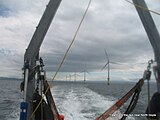 Trawling in the rain near North Hoyle wind farm.
 -
 Releasing tagged blonde ray (Raja brachyura).


Module 2. Animal distribution and abundance[edit]

Whilst movement studies will focus on several species, additional approaches will allow us to look at the full range of macrospecies present in the biological communities within the MREI (test) and adjacent (control) sites. This will allow an insight into potential impacts on the biodiversity around renewable energy installations (Inger et al., 2009) [11]
Relative abundance of animals in test and control areas will be quantified using a novel combination of methods. Communities of mobile macrobenthic invertebrates, fish, seabirds and marine mammals will be sampled. A balanced experimental design, of deployed static sampling gear consisting of baited traps for invertebrates and baited remote underwater videos (BRUVs) to provide data on benthic and demersal fish abundance and on habitat types where species abunndance is high. Recent research shows that BRUVs provide relative abundance estimates comparable to those derived by static gear, such as longlines and nets, e.g. (Brooks et al., 2011) [12]
Sampling gear will be deployed at set stations within test and control areas that are closely matched for principal habitat type (e.g. depth, substratum type). Estimates of relative abundance of shoaling fish in the water column will also be made from surveys using Cefas's dual-frequency split-screen sonar. Furthermore, top predator relative abundance in test and control areas will be quantified from monthly shipborne, visual surveys (seabirds) and long-term deployments of C-POD devices that record the number and type of marine mammal vocalisations together with ambient environmental noise levels.
-
Baited cameras awaiting deployment.
-
 Experimental pots awaiting deployment.
 -
Noise equipment being lowered to seabed at offshore test site.
-
 CPOD monitoring equipment for listening to dolphins & porpoises.


This combined approach will allow the macrobenthic invertebrate, fish, seabird and marine mammal communities present in test and control areas to be quantified through time. This will provide important population biological data for estimating changes in relative abundance of not only the tracked species, but the communities they are part of. The research is describing animal community sampling at the Wave Hub site (Witt et al., 2012) [13]
There is considerable added value to the current project in the availability of time series of seabird surveys and passive acoustic monitoring of marine mammals at the Wave Hub site since 2008. At the North Hoyle site the entire suite of sampling surveys will be undertaken should additional funding be provided to Module 6. Notwithstanding further funding support, annual environmental monitoring data for fish and epibenthic invertebrates at North Hoyle will be available to this project through QBEX's links with CMACS Ltd.
Commercial fishing activities in control areas will be monitored and assessed using Vessel Monitoring Scheme (VMS) data (Witt & Godley, 2007). [14]
Both Exeter and MBA partners have extensive experience of validating and using such data for spatial analyses. We aim to integrate all data collected to analyse interactions and relationships in spatial distribution. Together these methods allow a multi-trophic perspective as well as contributing to informing concerns regarding impacts of MREIs on higher vertebrates and their overlap with fisheries.
-
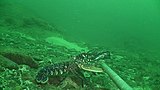
 Nursehound.
 -
 Common dolphin.
 -
 Manx shearwater.
 -
 Lobster


Module 3. Integration of animal movements with physical characterisation[edit]
Estimations of fish and large invertebrate (shellfish) biomass ‘spillover’ from MREI to adjacent areas depend on accurate measurements of changes in movement/space use patterns of animals that result in changes in spatial distributions over longer time scales (see Module 1). Prior to making such estimates it is necessary to explore how animal movements, both within and outside MREI areas and further afield (due to longer range migration or dispersal events), are influenced directly by physical factors. For example, it is conceivable that the differential habitat use shown by fish across an MREI site may be linked to heterogeneous physical fields such as variability in current velocity etc. irrespective of factors linked more closely to the exclusion of fishing per se. Therefore, animal movements and changes in relative abundance are related to data on waves and current fields and background and anthropogenic noise (broadband sound) at the appropriate scales to identify potential physical influences to dispersal and re-distribution.
We are adopting both Eulerian and Lagrangian approaches for testing significant associations between animal space use and environmental variations. We are analysing time series of space use (presence/absence) derived from acoustic monitoring (fish, marine mammals) in test and control sites with time series of remotely sensed physical data e.g. current velocities and wave heights from both test and control areas. Specifically for fish space use recorded by the acoustic monitoring array, we are employing novel methods (Jacoby, et al., 2012)[15] that use social network theory to determine how animals move freely within their environment. By assigning specific habitat or locations (such as acoustic transceivers) as network nodes and the movement of individuals between these locations as the connections between these nodes, rigorous descriptive and statistical analyses are performed on the global and local properties of an animals' movement. This novel approach is likely to offer a new, more holistic method for analysing small-scale animal movement from telemetry data. Explicitly, these analyses have the potential to describe home range behaviour, passive and transient space use and the possible outcome of targeted disturbance upon a movement network at the individual or population level, so are well suited for characterising and quantifying differences in space use of individuals between test and control sites and in relation to changes in environmental fields. We propose to derive temporal changes in two-dimensional physical fields from HF radar-derived sea surface measurements of wave height and current velocity, specifically the UoP PRIMaRE HF Radar Environmental Monitoring Facility and for water temperature and primary productivity from satellite remote sensing.
Lagrangian trajectories of individual fish calculated from electronic tag data using a tidal-geolocation algorithm are related to wider scale changes in two-dimensional modelled physical fields through time. Influence of physical factors on dispersal patterns and distributional changes is tested using null model (random walk) simulations to identify the extent to which the environment determines the patterns and scale of movements. The research team have particular expertise in this area of work (see Sims, et al., (2006[16] 2008)[17]. It will be possible using this approach to examine whether animals remain in particular areas more often than would be expected compared with random, or if movement distances and directions were solely determined by physical factors (e.g. current velocity). This will enable assessment of how site attached animals might be to MREI (test) and adjacent (control) sites, and over what time periods and times of year.
Module 4. Estimating ‘spillover’ from spatial dynamics and abundance and its effects on fisheries[edit]
The approach taken in Module 4 is to estimate spillover empirically using fish/shellfish movement and abundance data, and to develop and test individual-based spatial models of potential spillover effects on fisheries and its implications for sustainable exploitation.
The movement data of fish and shellfish will be used to estimate spillover in two principal ways. First, animal presence data at transceivers for all individuals will be compared between MREI (test) and adjacent (control) sites to determine whether the mean number of transmitter pings per fish (a higher number being proportional to greater time spent per area) is greater in test vs control sites. The spatial dynamics of any difference identified will be investigated using the spatial-network analysis described previously (see Module 3). We will use this to test hypotheses: for example, if the test area has a higher mean fish/shellfish presence compared with adjacent areas, is that a year-round characteristic or does it change over shorter time scales? Hence, what is the net movement rate between test and control areas? This will be quantified statistically after stratifying the analysis for area preference. The acoustic array presence/absence data will also be used to compare changes between test and control sites with relative abundance changes for focal (tracked) species recorded during experimental sampling (Module 2). This comparison will allow validation of the individual presence/absence data as a proxy for relative abundance of focal species within test and control areas. The second empirical approach will analyse the track reconstructions from returned data storage tags to provide temporally resolved maps of individual movements and areas occupied by that species. These data give changes in species distribution such that changes in location frequency per test vs control sites can be analysed for increasing time periods (e.g. from one month to one year). The purpose of this approach is to estimate the proportions of time individual animals spend in test and control areas and the timing and rates of movement between those areas. Both approaches will inform the modelling work to enable robust up scaling from individuals to population-level movement rates and space use. The combination of empirical and modelling approaches will provide more realistic estimates of any potential spillover between test and control sites and its impacts on fisheries.
The implications of MREIs for commercial fisheries will depend crucially upon how their physical presence and operations affect space use by both target species and fishers. Spatial fishery models show that rates of exchange of animals between areas accessible and inaccessible to fishing determine outcomes in terms of both spawning potential and fishery yield. We will use an individual-based modelling (IBM) approach to identify how patterns of space use by fish/shellfish determine these outcomes when MREIs are introduced into stock areas. Track reconstructions from data storage tags (Module 1), together with information on how movement patterns relate to environmental variations (Module 2), will be used to generate decision rules for simulating animal movements in relation to development areas. Targeting behaviour and response to exclusion zones by fishers will be modelled based on analysis of VMS data for control areas (Module 2). The IBM framework will be applied to assess the fishery implications of MREI scenarios, particularly in relation to targets and thresholds for sustainable exploitation.
Module 5. Determining the social and economic costs and benefits of ‘spillover’ from MREIs to inform marine spatial planning decisions[edit]
Working with local stakeholders (commercial fishers, recreational anglers, MMO, IFCA and MREI developers), the costs and benefits of fishing exclusion zones in MREIs will be assessed. We will use our well established links with fishers and local agencies such as the IFCAs (formerly known as Sea Fisheries Authorities) to assist in collecting socio-economic data through questioning relevant operators. The areas used by these will be gathered using maps of the case study sites during face-to-face interviews and through secondary data (including that from Module 2) that will be collated from local IFCAs and the MMO for all vessels that use the areas around MREIs in case study sites. We will use the data to explore changes in areas used for fishing in recent times. Correlations between data on the areas used for fishing and the data on animal movement, abundance and distribution (Modules 1 and 2) will be performed to understand how fishers are adapting to any spillover effect.
To further explore the perceptions and attitudes of fishers, their leaders and businesses towards the establishment of fisheries exclusion zones around MREIs, the data gathering will seek respondents' views to such co-location. These questions using Likert scale responses with particular statements such as a level of support for establishing no-take areas in MREI arrays. The data gathering will also ask respondents to rank or rate perceived changes in factors such as catches, displacement effects and conflicts before and after the establishment of MREIs, and mechanisms of how such conflicts could be addressed. We are highly capable in analysing these types of data using ordination techniques (e.g. non-metric-multidimensional scaling) to compare scores between fishermen and their administrators, while maintaining complete confidentiality of all individual respondents. This analysis will refine our understanding of the socio-economics of co-locating marine protected areas and MREIs and provide sound information for use in marine spatial planning.
Future modules[edit]
Several additional modules are being examined.
See also[edit]
References[edit]
- ^ DECC (2009). "UK Low Carbon Transition Plan" (PDF).
{{cite journal}}: Cite journal requires|journal=(help) - ^ EU Official Journal (5 June 2009). "Regulation (EC) No 443/2009 of the European Parliament and of the Council., June 2009" (PDF). Official Journal of the European Union. 52 (L140, 52). doi:10.3000/17252555.L_2009.140.eng.
{{cite journal}}: CS1 maint: date and year (link) - ^ The Parliamentary Office of Science and Technology (2008). "Marine conservation zones June 2008" (PDF).
{{cite journal}}: Cite journal requires|journal=(help) - ^ ABPMer (2011). "Quantifying the Potential Impact of a Marine Conservation Zone (MCZ) Network on the Deployment of Offshore Renewables, March 2011" (PDF).
{{cite journal}}: Cite journal requires|journal=(help) - ^ DECC (2011). "DECC explanatory note: ABPmer study to quantify the potential impact of a Marine Conservation Zone (MCZ) Network on the deployment of offshore renewables., September 2011" (PDF).
{{cite journal}}: Cite journal requires|journal=(help) - ^ Vega Fernández, T.; d'Anna, G.; Badalamenti, F.; Pérez-Ruzafa, A. (31 January 2008). "Habitat connectivity as a factor affecting fish assemblages in temperate reefs". Aquatic Biology. 1 (6): 239–248. doi:10.3354/ab00027.
{{cite journal}}: CS1 maint: date and year (link) - ^ Leitão, Francisco; Santos, Miguel N.; Erzini, Karim; Monteiro, Carlos C. (December 2008). "Fish assemblages and rapid colonization after enlargement of an artificial reef off the Algarve coast (Southern Portugal)". Marine Ecology. 29 (4): 435–448. doi:10.1111/j.1439-0485.2008.00253.x.
{{cite journal}}: CS1 maint: date and year (link) - ^ Bohnsack, James A. (September 1994). "Effects of Reef Size on Colonization and Assemblage Structure of Fishes at Artificial Reefs Off Southeastern Florida, U.S.A.)". Bulletin of Marine Science. 55 (2–3): 796–823.
{{cite journal}}: Unknown parameter|coauthors=ignored (|author=suggested) (help)CS1 maint: date and year (link) - ^ The Parliamentary Office of Science and Technology (2009). "Marine renewables January 2009" (PDF).
{{cite journal}}: Cite journal requires|journal=(help) - ^ Pedersen, M. W.; Righton, D.; Thygesen, U. H.; Andersen, K. H.; Madsen, H. (1 November 2008). "Geolocation of North Sea cod (Gadus morhua) using hidden Markov models and behavioural switching". Canadian Journal of Fisheries and Aquatic Sciences. 65 (11): 2367–2377. doi:10.1139/F08-144.
{{cite journal}}: CS1 maint: date and year (link) - ^ Inger, Richard; Attrill, Martin J.; Bearhop, Stuart; Broderick, Annette C.; James Grecian, W.; Hodgson, David J.; Mills, Cheryl; Sheehan, Emma; Votier, Stephen C.; Witt, Matthew J.; Godley, Brendan J. (15 September 2009). "Marine Renenewable Energy: potential benefits to biodiversity? An urgent call for research". Journal of Applied Ecology. 46 (6): 1139–1357. doi:10.1111/j.1365-2664.2009.01697.x.
{{cite journal}}: CS1 maint: date and year (link) - ^ Brooks, EJ; Sloman, KA; Sims, DW; Danylchuk, AJ (17 March 2011). "Validating the use of bated remote underwater video surveys for assessing the diversity, distribution and abundance of sharks in the Bahamas". Endangered Species Research. 13 (3): 231–243. doi:10.3354/esr00331.
{{cite journal}}: CS1 maint: date and year (link) - ^ Witt, M. J.; Sheehan, E. V.; Bearhop, S.; Broderick, A. C.; Conley, D. C.; Cotterell, S. P.; Crow, E.; Grecian, W. J.; Halsband, C.; Hodgson, D. J.; Hosegood, P.; Inger, R.; Miller, P. I.; Sims, D. W.; Thompson, R. C.; Vanstaen, K.; Votier, S. C.; Attrill, M. J.; Godley, B. J. (28 January 2012). "Assessing wave energy effects on biodiversity: the Wave Hub experience". Phil. Trans. R. Soc. A. 370 (1959): 502–529. doi:10.1098/rsta.2011.0265. PMID 22184674.
{{cite journal}}: CS1 maint: date and year (link) - ^ Witt, Matthew J.; Godley, Brendan J. (31 October 2007). "A Step Towards Seascape Scale Conservation: Using Vessel Monitoring Systems (VMS) to Map Fishing Activity". PLOS ONE. 2 (10): ?. doi:10.1371/journal.pone.0001111. PMC 2040201. PMID 17971874.
{{cite journal}}: CS1 maint: date and year (link) - ^ Jacoby, David M. P.; Brooks, Edward J.; Croft, Darren P.; Sims, David W. (2012). "Developing a deeper understanding of animal movements and spatial dynamics through novel application of network analyses". Methods in Ecology and Evolution. 3 (3): 574–583. doi:10.1111/j.2041-210X.2012.00187.x.
{{cite journal}}: CS1 maint: date and year (link) - ^ Sims, David W.; Witt, Matthew J.; Richardson, Anthony J.; Southall, Emily J.; Metcalfe, Julian D. (22 May 2006). "Encounter success of free-ranging marine predator movements across a dynamic prey landscape". Proceedings of the Royal Society B. 273 (1591): 1195–1201. doi:10.1098/rspb.2005.3444. PMC 1560279. PMID 16720391.
{{cite journal}}: CS1 maint: date and year (link) - ^ Sims, David W.; Southall, Emily J.; Humphries, Nicolas E.; Hays, Graeme C.; Bradshaw, Corey J. A.; Pitchford, Jonathan W.; James, Alex; Ahmed, Mohammed Z.; Brierley, Andrew S.; Hindell, Mark A.; Morritt, David; Musyl, Michael K.; Righton, David; Shepard, Emily L. C.; Wearmouth, Victoria J.; Wilson, Rory P.; Witt, Matthew J.; Metcalfe, Julian D. (28 February 2008). "Scaling laws of marine predator search behaviour". Nature. 451 (7182): 1098–1103. doi:10.1038/nature06518. PMID 18305542.
{{cite journal}}: CS1 maint: date and year (link)
Further reading[edit]
- Abecasis, D., Bentes, L. & Erzini, K. (2009). Home range, residency and movements of Diplodus sargus and Diplodus vulgaris in a coastal lagoon: Connectivity between nursery and adult habitats. Estuarine Coastal and Shelf Science, 85, (4): 525–529.
- Anderson, T. W. (2001). Predator responses, prey refuges, and density-dependent mortality of a marine fish. Ecology, 82, (1): 245–257.
- Bohnsack, J. A. (1989). Are high-densities of fishes at artificial reefs the result of habitat limitation or behavioural preference? Bulletin of Marine Science, 44, (2): 631–645.
- Bohnsack, J. A., Harper, D. E., McClellan, D. B. & Hulsbeck, M. (1994). Effects of reef size on colonization and assemblage structure of fishes at artificial reefs off southeastern Florida, USA. Bulletin of Marine Science, 55, (2-3): 796–823.
- Dempster, T. & Kingsford, M. J. (2003). Homing of pelagic fish to fish aggregation devices (FADs): the role of sensory cues. Marine Ecology-Progress Series, 258, 213–222.
- Fabi, G. & Sala, A. (2002). An assessment of biomass and diel activity of fish at an artificial reef (Adriatic sea) using a stationary hydroacoustic technique. Ices Journal of Marine Science, 59, (2): 411–420.
- Fernandez, T. V., D'Anna, G., Badalamenti, F. & Perez-Ruzafa, A. (2008). Habitat connectivity as a factor affecting fish assemblages in temperate reefs. Aquatic Biology, 1, (3): 239–248.
- Fowler, A. J., Jensen, A. C., Collins, K. J. & Smith, I. P. (1999). Age structure and diel activity of pouting on the Poole Bay artificial reef. Journal of fish biology, 54, (5): 944–954.
- Grossman, G. D., Jones, G. P. & Seaman, W. J. (1997). Do artificial reefs increase regional fish production? A review of existing data. Fisheries, 22, (4): 17–23.
- Hong, S. W., Okamoto, M., Imai, T. & Fuwa, S. (1998). Studies on the school behavior of fish around a submerged artificial plant. Nippon Suisan Gakkaishi, 64, (6): 966–974.
- Jan, R. Q., Liu, Y. H., Chen, C. Y., Wang, M. C., Song, G. S., Lin, H. C. & Shao, K. T. (2003). Effects of pile size of artificial reefs on the standing stocks of fishes. Fisheries Research, 63, (3): 327–337.
- La Mesa, G., Longobardi, A., Sacco, F. & Marino, G. (2008). First release of hatchery juveniles of the dusky grouper Epinephelus marginatus (Lowe, 1834) (Serranidae: Teleostei) at artificial reefs in the Mediterranean: results from a pilot study. Scientia Marina, 72, (4): 743–756.
- Langhamer, O. & Wilhelmsson, D. (2009). Colonisation of fish and crabs of wave energy foundations and the effects of manufactured holes - A field experiment. Marine Environmental Research, 68, (4): 151–157.
- Leitao, F., Santos, M. N., Erzini, K. & Monteiro, C. C. (2008). Fish assemblages and rapid colonization after enlargement of an artificial reef off the Algarve coast (Southern Portugal). Marine Ecology-an Evolutionary Perspective, 29, (4): 435–448.
- Lino, P. G., Bentes, L., Abecasis, D., dos Santos, M. N. & Erzini, K. (2009). Comparative behavior of wild and hatchery reared White Sea Bream (Diplodus sargus) released on artificial reefs off the Algarve (Southern Portugal). Tagging and Tracking of Marine Animals with Electronic Devices, 9, 23–34.
- Reubens, J. T., Degraer, S. & Vincx, M. (2011). Aggregation and feeding behaviour of pouting (Trisopterus luscus) at wind turbines in the Belgian part of the North Sea. Fisheries Research, 108, (1): 223–227.
- Rodriguez-Cabello, C., Sanchez, F., Serrano, A. & Olaso, I. (2008). Effects of closed trawl fishery areas on some elasmobranch species in the Cantabrian Sea. Journal of Marine Systems, 72, (1-4): 418–428.
- Sala, A., Fabi, G. & Manoukian, S. (2007). Vertical diel dynamic of fish assemblage associated with an artificial reef (Northern Adriatic Sea). Scientia Marina, 71, (2): 355–364.
- Santos, M. N., Lino, P. G., Pousao-Ferreira, P. & Monteiro, C. C. (2006). Preliminary results of hatchery-reared seabreams released at artificial reefs off the Algarve coast (southern Portugal): A pilot study. Bulletin of Marine Science, 78, (1): 177–184.
External links[edit]
- Natural Environment Research Council
- Department of Food and Rural Affairs
- Marine Biological Association
- University of Exeter, Cornwall Campus
- University of Plymouth
- Heriott-Watt, International Centre for Island Technology, Orkney Campus
- Plymouth Marine Laboratory
- Centre for Environment, Fisheries & Aquaculture Science, Lowestoft
- NOC Marine Renewable Energy
- UoP PRIMaRE HF Radar Environmental Monitoring Facility
- PRIMaRE
- Marine Conservation Zone network