
User:Heathmoor/Torà
| This is not a Wikipedia article: It is an individual user's work-in-progress page, and may be incomplete and/or unreliable. For guidance on developing this draft, see Wikipedia:So you made a userspace draft. Find sources: Google (books · news · scholar · free images · WP refs) · FENS · JSTOR · TWL |
Torà | |
|---|---|
Town | |
 Torà - Street | |
 Torà Location in Catalonia | |
| Coordinates: 41°48′41.05″N 001°24′13.88″E / 41.8114028°N 1.4038556°E | |
| Country | Spain |
| Region | Catalonia |
| Government | |
| • Mayor | Domènec Oliva Bonsfills |
| Area | |
| • Land | 93.3 km2 (36.0 sq mi) |
| Elevation | 448 m (1,470 ft) |
| Population (2008) | |
| • Total | 1,370 |
| Demonym | toranès/toranesa |
| Time zone | UTC+1 (CET) |
| • Summer (DST) | UTC+2 (CEST) |
| Postal code | 25750 |
| Area code | 34 (Spain) + 973 (Lleida) |
Torà (Catalan pronunciation: [tuˈɾa]; Spanish: Torá, pronounced [toˈɾa]) is a town and municipality in the North East of the comarca of Segarra, in the province of Lleida, Catalonia, Spain.
In 1968, the former municipality of Llanera was integrated to Torà. The municipality stretches along la Vall (valley) de la Riera (creek) de Llanera up to the confluence with the Llobregós River. The North sector's orography is rather uneven, with el Tossal (hill) de l'Aguda, el Tossal de Sant Donat rising up to 850m above sea level, and la Riera (creek) de Llanera flowing across. The South sector also features el Tossal de Sant Pere and el Tossal de la Pineda. La Riera (brook) de Cellers, a Riera de Llanera's tributary on the left side. The town is settled on the left bank of la Riera de Llanera, near the confluence with the Llobregós River, down la Serra (mountain range) de l'Aguda[1].
Districts and neighbourhoods[edit]
Torà is divided in the following population entities:
Culture[edit]
History[edit]
In 1003 there was a battle of the Reconquista fought between an alliance of Catalonian counts and an army of the Caliphate of Córdoba at Torà.
Festivals[edit]
The Village's Festival on 1 September and around the Summer's solstice, some neighborhood's verbenas (country fairs).

Landmarks[edit]
Municipal constructions[edit]


- Plaça de la Font (fountain's square)
- Plaça del Vall (City Hall's Square)
- Font dels Dolors (public fountain)
- Casa de la Vila (City Hall)
- Pou del Gel iIce well)
- Cementiri (graveyard)
Military constructions and buildings[edit]
- Castell de L'Aguda (Castle) a l'Aguda de Torà (ruins, expoliated)
- Torre de Vallferosa (Tower): a Vallferosa (highly restored)
- Casa Castell de Llanera in Llanera (fortified manor house, very damaged, expoliated)
Romanesque architecture[edit]
- Monestir de Cellers (monastery): with three crossing abses and a crypt, in Cellers
- Església de Sant Salvador (church): in l'Aguda de Torà
- Església de Sant Miquel (church): in Fontanet
- Església de Claret (church), XII Century (highly reformed)
Other monumental buildings[edit]
- El Convent (convent)
- L'Hostal (hostal)
- Església de Santa Maria (church): in Llanera (expoliated)
- Església de Santa Maria (church): in Vallferosa (expoliated)
Communications[edit]
Torà is along the county road C-1412. Coming from Balaguer, C-1313 towards La Seu d'Urgell until Ponts and then, the road C-1412 towards Calaf. Coming from Cervera, the national road N-141, then the local road LV-3003[2].
Demographics[edit]
| 1900 | 1930 | 1950 | 1970 | 1986 | 2008 |
|---|---|---|---|---|---|
| 1,303 | 1,567 | 1,511 | 1,335 | n/a | 1,333 |
Demographic data source[3].
-
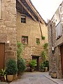 Torà - Street
 -
 Torà in Christmas
 -
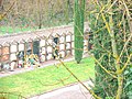 Torà - Cementery
 -
 Ca na Núria
See also[edit]
References[edit]
- ^ http://cat.lleida.com/municipi/?municipi=2522340003 Lleida.com
- ^ http://cat.lleida.com/municipi/?municipi=2522340003 Lleida.com
- ^ http://www.idescat.cat/territ/BasicTerr?TC=6&V0=1&CTX=B&ALLINFO=TRUE&V1=25223&VOK=Confirmar idescat: Web de l'estadística oficial de Catalunya
External links[edit]
- Torà's City Hall's Website
- Borough's Database
- APACTorà: Associació del Patrimoni Artístic i Cultural de Torà (Local Cutural Association)
- Local Popular Website
- Website devoted to the Llobregós River Natural Place