
User:Jnestorius/Dublin baronies
| Parish | Part of parish | 1774 barony | 1842 barony | 1774 area | 1842 area | Notes | Logainm |
|---|---|---|---|---|---|---|---|
| Arderrig | all | ??? | Newcastle | Newcastle | |||
| Artaine | all | Coolock | Coolock | 557 | sic spelling | Coolock | |
| Baldongan | all | Balrothery | Balrothery East | 450 | "Ballydungan" in 1774 | Balrothery East | |
| Baldoyle | all | Coolock | Coolock | 450 | Coolock | ||
| Balgriffin | all | Coolock | Coolock | 540 | Coolock | ||
| Ballyboghil | all | Balrothery | Balrothery West | 1892 | Balrothery West | ||
| Ballyboght | all | Uppercross | ??? | 840 | prob townland of Ballybought now in Ballymore-Eustace | ||
| Ballyfermot | all | Newcastle | Uppercross | 500 | "Ballyfarmott" in 1774 | Uppercross | |
| Ballymadun | all | Balrothery | Balrothery West | 1726 | Balrothery West | ||
| Ballymore-Eustace | all | Uppercross | County Kildare | 2000 | Naas South, Co Kildare | ||
| Balrothery | all | Balrothery | Balrothery East | 3000 | Balrothery East | ||
| Balscaddan | all | Balrothery | Balrothery East | 1991 | Balrothery East | ||
| Booterstown | Intake townland | (County of the City of Dublin) | Dublin | See under Donnybrook | transferred from County of the City by 1840 Act. Part of Donnybrook in 1774.[1] | Dublin | |
| Booterstown | rest | ??? | Rathdown | Rathdown | |||
| Castleknock | all | Castleknock | Castleknock | 3465 | Castleknock | ||
| Chapelizod | all | Castleknock | Castleknock | 2198 | Castleknock | ||
| Cloghran [a] | all | Coolock | Coolock | 994 | "Cloghran, East” in 1842 | Coolock | |
| Cloghran [b] | all | Castleknock | Castleknock | 1615 | “Cloghran, West” in 1842 | Castleknock | |
| Clondalkin | Blundelstown townland | Uppercross | Newcastle | see rest | Newcastle | ||
| Clondalkin | rest | Uppercross | Uppercross | 3118 | 1774 Clondalkin town (1038) plus Clondalkin parish (2080) | Uppercross | |
| Clonmethan | all | Nethercross | Balrothery West | 2333 | "Clonmelkin" in 1774 | Balrothery West | |
| Clonsilla | all | Castleknock | Castleknock | 1615 | Castleknock | ||
| Clontarf | all | Coolock | Coolock | 535 | Coolock | ||
| Clonturk | all | Coolock | Coolock | 800 | Coolock | ||
| Coolock | all | Coolock | Coolock | 1199 | Coolock | ||
| Cruagh | all | Newcastle | Uppercross | 1800 | Uppercross | ||
| Crumlin | all | Newcastle | Uppercross | 1200 | Uppercross | ||
| Dalkey | Dalkey Island | ?? | Rathdown | see rest | 21a2r27p | Not sure if included in Uppercross (or indeed in Dalkey parish) in 1774 | Rathdown |
| Dalkey | rest | Uppercross | Rathdown | 158 | Rathdown | ||
| Donabate | all | Balrothery | Nethercross | 1560 | Nethercross | ||
| Donnybrook | Annefield, Simmonscourt, Priesthouse townlands | Rathdown | Rathdown | see rest | 373a3r26p | Rathdown | |
| Donnybrook | rest | Rathdown (? and County of the City of Dublin?) | Dublin (? and County of the City of Dublin?) | 648 | "Part" transferred from County of the City by 1840 Act; was it in Rathdown or city in 1774? Was other part still in County of the City after 1840 Act? See [1]. | Dublin | |
| Donnybrook | Sallymount, Clonskeagh townlands | ??? | Uppercross | 10a2r0p | 10 0 32 plus 0 1 8. See also [1]. | Uppercross | |
| Drimnagh | all | ??? | Uppercross | aaa | Uppercross | ||
| Dunlavin | all | Uppercross | 1400 | “Milltown Dunlavin” in 1774 | Talbotstown Upper / Talbotstown Lower, Wicklow | ||
| Esker | Coldart and Esker townlands | Newcastle | Uppercross | see rest | Uppercross | ||
| Esker | Coldcut, Rowlagh | ??? | Uppercross | 141a1r0p | 38.2 and 102.3 resp | Uppercross | |
| Esker | rest | Newcastle | Newcastle | 1500 | Newcastle | ||
| Finglas | Ballystrahan, Kilreesh, Laurestown, Skephubble, Toberburr, Westereave townlands | Nethercross | Nethercross | see rest | Nethercross | ||
| Finglas | rest | Nethercross | Castleknock | tot 2023 | Castleknock | ||
| Garristown | all | Balrothery | Balrothery West | 2072 | Balrothery West | ||
| Glasnevin | part | Coolock | Coolock | 600 | Coolock | ||
| Glasnevin | rest | (?Coolock and/or Co of City?) | Co of City | see rest | Was inside the Co of City before and after 1840; not sure if some or all was in county in 1774. | Dublin City | |
| Grallagh | all | ?? | Balrothery West | Balrothery West | |||
| Grangegorman | part | Coolock | Coolock | 450 | Coolock | ||
| Grangegorman | rest | (?Coolock and/or Co of City?) | Co of City | see rest | Was inside the Co of City before and after 1840; not sure if some or all was in county in 1774. | Dublin City | |
| Hollywood | all | Balrothery | Balrothery West | 2599 | Balrothery West | ||
| Holmpatrick | all | Balrothery | Balrothery East | 1063 | Balrothery East | ||
| Howth | all | Coolock | Coolock | 1772 | Coolock | ||
| Kilbegh | all | Coolock | ?? | 500 | Maybe = Kilbarrack ? | ||
| Kilbarrack | all | Coolock | Coolock | ||||
| Kilbride | all | ??? | Newcastle | Not Kilbride, County Wicklow? Near Baldonnell. | Newcastle | ||
| Kilgobbin | all | Rathdown | Rathdown | 750 | Rathdown | ||
| Kill | all | Rathdown | Rathdown | 230 | Rathdown | ||
| Killeek | all | ?? | Nethercross | Nethercross | |||
| Killester | all | Coolock | Coolock | 150 | Coolock | ||
| Killiney | all | Rathdown | Rathdown | 542 | Rathdown | ||
| Killossery | all | Coolock | Nethercross | 900 | Nethercross | ||
| Kilmactalway | all | Newcastle | Newcastle | 1500 | Newcastle | ||
| Kilmacud | all | ??? | Rathdown | Rathdown | |||
| Kilmahuddrick | all | ??? | Newcastle | Newcastle | |||
| Kilmainham | all | Newcastle | ??? | 1200 | cf St Jude's | ||
| Kilsallaghan | Castleknock | Nethercross | 1448 | Nethercross | |||
| Kiltiernan | all | Rathdown | Rathdown | 450 | Rathdown | ||
| Kinsaley | all | Coolock | Coolock | 1339 | "Kingsalley" in 1774 | Coolock | |
| Leixlip | all | ??? | Newcastle | Newcastle | |||
| Liberties of Christ Church | all | Dublin City | |||||
| Liberties of St. Patrick's | all | St. Sepulchre's | (?Co of city?) | 426 | “Patrick's-Close” in 1774 | Dublin City | |
| Lucan | all | Newcastle | Newcastle | 1200 | Newcastle | ||
| Lusk | East Lusk and West Lusk | Balrothery | Balrothery East | 4346 | 1774 East Lusk (2501) and West Lusk (1845) | Balrothery East | |
| Lusk | Middle Lusk | Nethercross | Balrothery East | 3787 | Called simply "Lusk" in 1774; Lewis 1837 says "The parish is divided into three parts, called East, West, and Middle Lusk, of which the last is in the barony of Nethercross, and the two former in that of Balrothery."[2] | Balrothery East | |
| Malahide | all | Coolock | Coolock | 606 | Coolock | ||
| Monkstown | New Town Blackrock townland | Rathdown | Dublin | see rest | transferred from County of the City by 1840 Act; was it in Rathdown or city in 1774? | Dublin | |
| Monkstown | rest | Rathdown | Rathdown | 1253 | Rathdown | ||
| Mulhuddart | all | Castleknock | Castleknock | 729 | Castleknock | ||
| Naul | all | Balrothery | Balrothery West | 1411 | Balrothery West | ||
| New-street and Poddle | all | St. Sepulchre's | (?Co of city?) | 642 | No record of parish(es) of the name(s), but two wards of the Liberty of St. Sepulchre in 1836 had those names, and Kevin's without and within were the other two.[3] | ||
| Newcastle | all | Newcastle | Newcastle | 2000 | Newcastle | ||
| Old Connaught | all | Rathdown | Rathdown | 700 | Rathdown | ||
| Palmerston | all | Newcastle | Uppercross | 700 | "Palmerstown" in 1774; “Palmerstown, South” in 1842 | Uppercross | |
| Palmerstown | all | Balrothery | Balrothery West | 851 | Balrothery West | ||
| Portmarnock | all | Coolock | |||||
| Portmarnock | all | Coolock | Coolock | 1020 | |||
| Portraine | Excl Lambay Island | Castleknock | Castleknock | 705 | “Portrane” 174 and 1842 | Nethercross | |
| Portraine | Lambay Island | ? | Castleknock | 595a3r0p | Not in Portrane parish in 1774? | Nethercross | |
| Raheny | all | Coolock | Coolock | 440 | Coolock | ||
| Rathcoole | all | Uppercross | Newcastle | 1600 | 1774 Rathcoole town (241) plus Rathcoole parish (1359) | Newcastle | |
| Rathfarnham | rest | Newcastle | Rathdown | 1200 | Rathdown | ||
| Rathfarnham | Scholarstown townland | Newcastle | Uppercross | see rest | Uppercross | ||
| Rathmichael | all | Rathdown | Rathdown | 460 | Rathdown | ||
| Saggart | all | Newcastle | Newcastle | 2000 | Newcastle | ||
| St. Andrew's | all | Dublin City | |||||
| St. Anne's | all | Dublin City | |||||
| St. Audeon's | all | Dublin City | |||||
| St. Bartholomew's | all | Dublin | |||||
| St. Bridget's | all | Dublin City | |||||
| St. Catherine's | Part | [Donore in 1821[4]] | Uppercross | Double-check 1774/1842 | Dublin City | ||
| St. Catherine's | Part | ??? | Uppercross | Uppercross | |||
| St. George's | Part | Coolock | Coolock | ||||
| St. George's | rest | Co. of City | Dublin City | ||||
| St. James's | Great Eastern Entrance to the Phoenix Park | Co of City | Castleknock | 3a0r10p | Castleknock | ||
| St. James's | Part N of Liffey outside Municipal Boundary | (?Co. of City?) | Castleknock | Castleknock | |||
| St. James's | Part S of Liffey outside Municipal Boundary | Co. of City (? and other?) | Castleknock | 29p (?and more) | I think 1842 should be Uppercross | Uppercross | |
| St. James's | rest | Co. of City | Co. of City | Dublin City | |||
| St. John's | all | Dublin City | |||||
| St. John's | Part | Post-1842 parish; cf. Kilmainham | Castleknock | ||||
| St. Jude's | Part | Post-1842 parish; cf. Kilmainham | Dublin City | ||||
| St. Jude's | Part | Post-1842 parish; cf. Kilmainham | Uppercross | ||||
| St. Luke's | all | [Donore in 1821[4]] | Dublin City | ||||
| St. Margaret's | all | Coolock | Coolock | 1140 | Coolock | ||
| St. Mark's | Part | (County of the City of Dublin) | Dublin | transferred from County of the City by 1840 Act | Dublin | ||
| St. Mark's | Part | Dublin City | |||||
| St. Mary's | all | Dublin City | |||||
| St. Michael's | all | Dublin City | |||||
| St. Michan's | all | Dublin City | |||||
| St. Nicholas Within | all | Dublin City | |||||
| St. Nicholas Without | without the Municipal Boundaries | [St Sepulchre's in 1821[5]] | Uppercross | aaa | Uppercross | ||
| St. Nicholas' Without | rest | [St Sepulchre's in 1821[5]] | Dublin City | ||||
| St. Paul's | all | Dublin City | |||||
| St. Peter's | Old St. Peter's | Co of city | Co of city | The part not in St Kevin's; none of it was in the liberties.[6] | Dublin City | ||
| St. Peter's | St. Kevin's within (and probably part of St. Kevin's without, north of the circular road) | St. Sepulchre's | Co of city | 306 (and probably part of 200) | In 1682, St Kevin's in the liberties was united with St. Peter's in the city, though to what extent remained uncertain.[6] St Kevin's was listed separately in 1831 census, footnoted as united with St Peter's and "connected with the City of Dublin".[7] | Dublin City | |
| St. Peter's | St. Kevin's without, north of the circular road (probably only part) | St. Sepulchre's | Dublin | 200 (probably less) | St Kevin's was united with St. Peter's in 1682.[6] Some was transferred from County of the City by 1840 Act | Dublin | |
| St. Peter's | St. Kevin's without, south of the circular road | Uppercross | Uppercross | 1790 | St Kevin's was united with St. Peter's in 1682.[6] | Uppercross | |
| St. Thomas's | all | Dublin City | |||||
| St. Werburgh's | all | Dublin City | |||||
| Santry | all | Coolock | Coolock | 2360 | Coolock | ||
| Shankill | all | Uppercross | ??? | 1001 | Shankill townland now in parish Rathmichael | ||
| Stillorgan | all | ??? | Rathdown | Rathdown | |||
| Swords | rest | Nethercross | Nethercross | tot 4762 | 1774 includes parish of Swords 3535 acres plus "town and liberty of Swords", 1227 acres. But Lewis 1837 includes the 1227 in the 3535.[8] | Nethercross | |
| Swords | Swords Glebe | Nethercross | Coolock | see rest | insulated in East Cloghran | Coolock | |
| Tallaght | all | Uppercross | Uppercross | 5135 | Uppercross | ||
| Taney | rest | Rathdown | Rathdown | 2591 | Rathdown | ||
| Taney | Roebuck townland | Rathdown | Dublin | transferred from County of the City by 1840 Act; was it in Rathdown or city in 1774? | Dublin | ||
| Tipperkevin | all | Uppercross | County Kildare | 1000 | “Tipper-Cavan” in 1774 | Naas South, Co Kildare | |
| Tully | all | Rathdown | Rathdown | 1513 | "Tallow" in 1774 | Rathdown | |
| Ward | all | Castleknock | Castleknock | 292 | Castleknock | ||
| Westpalstown | all | Balrothery | Balrothery West | 884 | Balrothery West | ||
| Whitechurch | all | Rathdown | Rathdown | 1500 | Rathdown | ||
| ??? | all | Donore | ?? | 2890 | Don't think 1774 "Donore" is a parish name at all. |
1837 Mun bdry rpt p.61 names "Deaneries of Christ Church and St. Patrick's" with but separate from parishes of the city.
Quotes[edit]
Otway‐Ruthven:[9]
- In the fourteenth century the county of Dublin was divided into the four serjeanties of the vale of Leinster (approximately the modern barony of Newcastle), Bree (the modern baronies of Rathdown in Dublin and Wicklow), and Fingal on either side of the water of Gower, which can be identified as the Broad Meadow Water (the whole county north of the Liffey), in addition to the Crosses, that is, the lands of the archbishop of Dublin, which were administered for most purposes by the archbishop's officials, not the king's, and included islands of territory scattered throughout the county, as well as most of the Wicklow mountains and Tipperkevin, Ballymore, and Ballybought. By 1455 the baronies of Newcastle of Lyons, Rathdown, Castleknock, Coolock, and Balrothery were in existence, while the Crosses continued as before. This was still the position in 1655, when the Civil Survey was made, with the Crosses divided into the baronies of Upper and Nether Cross. Substantial alterations in barony boundaries have since been made, but need not be detailed here.
J. H. Andrews:Andrews, J. H. (26 January 2010). "Medium and message in early six‐inch Irish ordnance maps : The case of Dublin city" (PDF). Irish Geography. 6 (5): 579–593 : 582. doi:10.1080/00750777309555704.
- Sheet 18 of the Dublin county map was engraved between June 1837 and December 1841 ... Throughout the country, an essential preliminary to the official mapping of the ground had been the delimitation of townlands, parishes, baronies and counties, and in 1825 a special department, independent of the Ordnance officers but in close touch with them, had been set up for this purpose. Until it reached Dublin the boundary department had usually managed to keep ahead of the survey proper; but in this county the territorial pattern was found to be so complex and irrational that the government decided not to publish the map until the boundaries had been reformed. When the reformation was finally given legal validity in August 1842 (5 & 6 Vic, c. 96), the Survey had to mount a quick programme of revision to catch up with the landscape changes of the six previous years.
A MAP of The Boundaries of the COUNTY of the CITY of DUBLIN on the North East side thereof (1805) "Beginning at the BROAD STONE and Ending at the termination of the CITY BOUNDARY on the NORTH EAST side of Said City" By order of "Commissioners appointed to ascertain said Boundaries", who were three aldermen and a council member, and "John Hamilton of Hacketstown in the County of Dublin".
Liberties and manors[edit]
(p.289) Within and adjoining to the city of Dublin are five local jurisdictions, which are in many respects exclusive, and independent of the authority of the corporation. Four of these extend, in part, within the limits of the county of the city, but all are so connected with the exercise of the municipal authority of the corporation, that, in reference to the purposes of our Commission, we have deemed it our duty to make inquiry into, and report upon them. The districts over which these local jurisdictions extend are called liberties or manors; they
- 1st. The liberty of St. Sepulchre.
- 2nd. The liberty or manor of Thomas Court and Donore.
- 3rd. The liberty of the Deanery of St. Patrick.
- 4th. The manor of Glassnevin or Grange Gorman, and liberty of Christ Church.
- 5th. The manor of Kilmainham.
- There was formerly a sixth, the manor of Mary's Abbey, but the exercise of all manorial jurisdiction therein has long ceased.
The first three are popularly called the Liberties. [*
- footnote The “liberties of the city,” mentioned in the 10 Geo. I. c. 3; 11 Geo. II. c. 11, s. 10; 11 Geo. II. c. 13, s. 3; 11, 12 Geo. III. c. 11, s. 50, and several other Acts, are evidently distinguished from the liberties of St. Sepulchre's, of Thomas Court and Donore, of St. Patrick's, and of Christ Church, which are described as liberties “adjoining" the city.]
Should add "liberty" and "manor" columns to table.
- Some few centuries after the establishment of Christianity in Ireland in the fifth century, those districts of the country, known by the name of Croceæ or Crosslands, were dedicated to the church, and most extensive jurisdiction was given to the abbots and bishops therein. Such were the Croceæ of Ulster, Kilkenny, Meath, Kildare, Louth, Kerry, Navan, Ferns, Carlow, Wexford, Leighlin, &c., and such, more particularly as concerns this history, were the Croceæ or liberties of the cross of the Archbishop of Dublin : and, as in England, the symbol of triumphant Christianity was frequently set up to mark the boundaries of civil districts, so in Ireland, but with more propriety, crosses, some of them very handsomely ornamented, were erected to distinguish the ecclesiastical possessions.
- The cross lands of Dublin appear to have been partly in the northern, and partly in the southern sections of the county, and indeed the names of two of its baronies, so respectively situated, Nether-Cross, and Upper-Cross, although not of course precisely commensurate with the ancient croceæ,[d 1] do still designate large portions of their superficies, and exhibit, in the scattered and insulated state of their component parts, the natural consequence of uniting in one civil division tracts so adventitiously appropriated. The Northern Croceæ retain some of the actual crosses as at St. Doulogh's and Finglas, while another, called pardon cross, is particularly recorded as having been erected at Swords. Clondalkin, Tullagh, St. Anne's, the Kill of the Grange, Kiltuc, and Rath
- ^ For example, Holmpatrick, Lambay, and Ireland's Eye, were in the Northern Croceæ, though the first is now accounted in Balrothery, the two last in Coolock Barony; and Tawney, now classed in Rathdown, was then in the Southern Croceæ.
Inconsistencies between the MunComm and ManorCt reports on which are manors. As to which civ pars are in each manor, no cps at all in MunComm, and only list in ManorCt, though ordering gives some clue as likely that cps relate to nearest manor in list. But really I need to use other sources to address these inconsistencies and gaps.
Monck 1820 p.xiii lists 13 prebendary parishes of StPats, which seem to overlap with those of the liberty. JSTOR p.4 31 March 1192 bull mentions parishes/prebends granted by Archbishop for canons of St Pats; Monck 1820 has the Latin text in an Appendix.
Close Roll 9 Edward II "WRIT of allocate for John Ufford, escheator, for the following sums in his account of the issues of the temporalities of the archbishopric of Dublin, 24 Feb. 1314 – 28 Sept. 1315" includes placenames
HISTORIC AND MUNICIPAL DOCUMENTS of IRELAND. A.D. 1172-1320. (Gilbert 1870) pp.365-371 "TEMPORALITIES OF VACANT SEE OF DUBLIN"
39th Rpt Dep K PRO of I Appendix pp.64-5 has Archbp and other church lands near Dublin
Cullenswood townland off Sandford Rd name shows was part of Colonia
1743 Jrnl Ir Hse Commons table of parishes and whether in city county or liberty.[10]
Lord Chancellor of Ireland quoted in 1828 court case: "I am still very much in the dark as to what I am to understand by the liberties and adjoining suburbs of the City of Dublin."[11]
1831 court discussion of use and meaning of "city suburbs and liberties of Dublin" and related phrases (case related to Manor of Grangegorman).[12]
liberty of St. Sepulchre[edit]
- [Municipal Corps Rpt 1835]
- The manor of St. Sepulchre, city and county of Dublin.
- city
- county
- North of SCR barony of St Sepulchre [13, 14 Geo. III., c. 34, s. 2]
- part of the parish of St. Peter's
- the entire of the parish of Nicholas without the walls,
- and the. old parish of St. Kevin.
- formerly the old parish of St. Patrick
- South of SCR barony of Uppercross
- North of SCR barony of St Sepulchre [13, 14 Geo. III., c. 34, s. 2]
- The manor of Tallaght, county of Dublin.
- The manor of Rathcoole or Clondalkin, county of Dublin.
- The manor of Shengyhill or Shankill, county of Dublin.
- The manor of Ballymore-Eustace, counties of Wicklow and Kildare.
- The manor of Castlekevin, county of Wicklow.
- The manor of Swords, including Lusk, Clonmelkin, and Rush, county of Dublin.
- The manor of Finglass, county of Dublin.
- The manor of St. Sepulchre, city and county of Dublin.
1264. Secular Powers of Archbishops of Dublin Historic and Municipal Documents of Ireland, A. D. 1172-1320 no. XLVII — inquisitions at 8 manors
"The principal Places over which the Jurisdiction of this Court extends ?" (answer reformatted to approximate manor 1st-level + cp 2nd-level):
- The town and liberty of Swords;
- the town and liberty of Lusk;
- parish of Portrane;
- parish of Clonmethan ;
- north side of parish of Swords ;
- south side of parish of Lusk ;
- town of Templeouge ;
- town of Tallaght;
- manor and town of Rathcoole or Clondalkin ;
- town and parish of Glasmusky; Glaise na Muice/Glassamucky
- parish of Tallaght;
- parish of Killbegg; [Kilbeg tld in Wicklow in Boystown cp http://www.logainm.ie/en/54883] D'Alton p.766 has The lands of the See [in Tallaght] were about this time defined as "the mountains, towns, and lands of Glasnamucky, Ballyslater, Killnasantan, and Castle Kelly, in the barony of Upper Cross and county of Dublin and Wicklow, or either of them, bounded, as before-mentioned, at " Killnasantan ;" and also the mountains, towns, and lands of Ballymakane, containing 20a. arable, being in the barony of Upper Cross and county of Wicklow aforesaid, mearing and bounding on the east to Kilbeg and Three Castles, on the south to the common bogs, on the west to Carrickasure, and on the north to the lands of Boyestown and Sheraghan, and also all that the farm and lands of Kiltipper, and also all that one field or small park on the lands of Tallagh, on the north side of a grove on the lands of Old Bawn, called the Cappagh Garden, being in the lordship of Tallagh and county of Dublin aforesaid, together with all marshes, buildings, orchards, waters, water-courses, bogs, moors, commons, turbaries, &c.
- parish of Cryhelp ; Craobh Eilpe/Crehelp
- outside of parish of Finglass;
- Kevins Without (Old);
- Kevins Within (Old);
- Poddleward (Old);
- New-street Ward (Old);
- Kevin's-street,
- Castleknock;
- manor of Baliymore Eustace;
- parish of Burgage ;
- parish of Granabegg; [tlds Granabeg Upr /Lwr, in Boystown cp http://www.logainm.ie/en/s?txt=in:2674&cat=BF]
- parish of Tippercevin ;
- parish of Ballybought;
- parish of Ballymore ;
- parish of Milltown Dunlavin; Milltown tld in Dunlavin cp
- manor of Finglass;
- manor of Shankhill; Lenekil or Soneighill;
- manor and parish of Dalkey;
- parish of Dunlavin;
- manor of Stackenel or Powerscourt; ECCLESIASTICAL SITE Steach gConaill/Churchtown || TOWNLAND Powerscourt Demesne || CIVIL PARISH Cúirt an Phaoraigh/Powerscourt
- manor of Castlekevin. Castlekevin tld in Derrylossary cp
JSTOR 25507699 says Liber Niger has them, and gives page references; JSTOR 25506504 pp.37-41 has Latin extent of Manor of StSep; JSTOR 25508054 is brief calendar of Liber Niger; "Calendar of Archbishop Alen's Register" published by RSAI in 1950.
Civil Survey Vol.7 (Dublin) has info and refers to earlier info
- pp.xx-xxvi
- list from 55 Hen. III. 5 Ed. I is:- Swerdes [Swordes], Ballymor, Clondolcan [Clondalkin], Finglas, Rathcul [Rathcool], Newtown, Taullath [Tallaght], Coloyne [St. Sepulchre's], Senekil [Shankhill], Castlekevyn, Kilmasantan, and Bretach [Brittas]
- It may be said that manors and parishes are frequently found to bear the same name, though it does not follow that they are equated in content.
- with the exception of Castlekevin and its members, were denominated the baronies of Uppercross and Nethercross
Dean's Lib[edit]
- 1835 Mun Corp: Liberty of the Dean and Chapter of the Cathedral Church of St. Patrick [Until the time of the Reformation the old parish of St. Patrick formed a part of the manor of St. Sepulchre, but at that period this parish was erected into a collegiate church, and created a distinct liberty]
- Monck 1820 p.18 says DeansLib always separate since initial grant by Archbp; but maybe
- [a] StSep argued DeansLib was subof Archbp's lib OR
- [b] StPat par larger extent than DeansLib
Meath / Thomas Court and Donore[edit]
Earl of Meath:[13]
- In July, 1713, he made his will, and thereby desired 8000l. to be issued out of the manor of Thomas-Court and Donore, Great and Little Bray, Kilruddery. Kinlestown, Temple-Delgany, and Coolegad, in the counties, of Dublin and Wicklow, for the portions and maintenance us his younger children, viz. 1000l. a-piece, and appointed his daughters, Catharine sod Frances, executors. (Prerog. Office, and Lodge.)
Parish of St Catherine's:[14]
- THIS Parish consists of three Districts, the accounts of which, with respect to Grand Jury are kept separate; viz.
- ist.—The City Liberty.
- 2d.—Thomas Court, or Earl of Meath's Liberty.
- 3d.—Part of the Barony of Donore, which lies in the County.
- The City Liberty and Thomas Court are liable to Grand Jury Cess.
- The Barony of Donore is not, but is subject to County Cess.
- The proportion of each Grand Jury Presentment is exhibited in the annexed scheme
Index to the townland survey of the County of Dublin 1843 (OS Map)
- includes baronies colour-coded and parishes delineated.
- Table with areas of parish by barony
- Inset maps and tables:
- "Ancient County of the City of Dublin and the Baronies of Donore, Thomas-court, St. Sepulchre and Liberties of St. Patrick's" [boundaries of all these and internal parished]
- "Parliamentary Borough of Dublin" [boundaries of internal parished]
Christ Church vs Glassnevin or Grange Gorman[edit]
MCI Rpt on Dublin, 1835, pp.289, 302-5 does not make clear whether
- "manor of Glassnevin" is synonym of "liberty of Christ Church"
- "manor of Glassnevin" is the area outside the city limits, "liberty of Christ Church" the precincts of the Cathedral enclaved by the city
- "manor of Glassnevin" is one of several manors [the others being unnamed in Rpt] which together make up the "liberty of Christ Church"
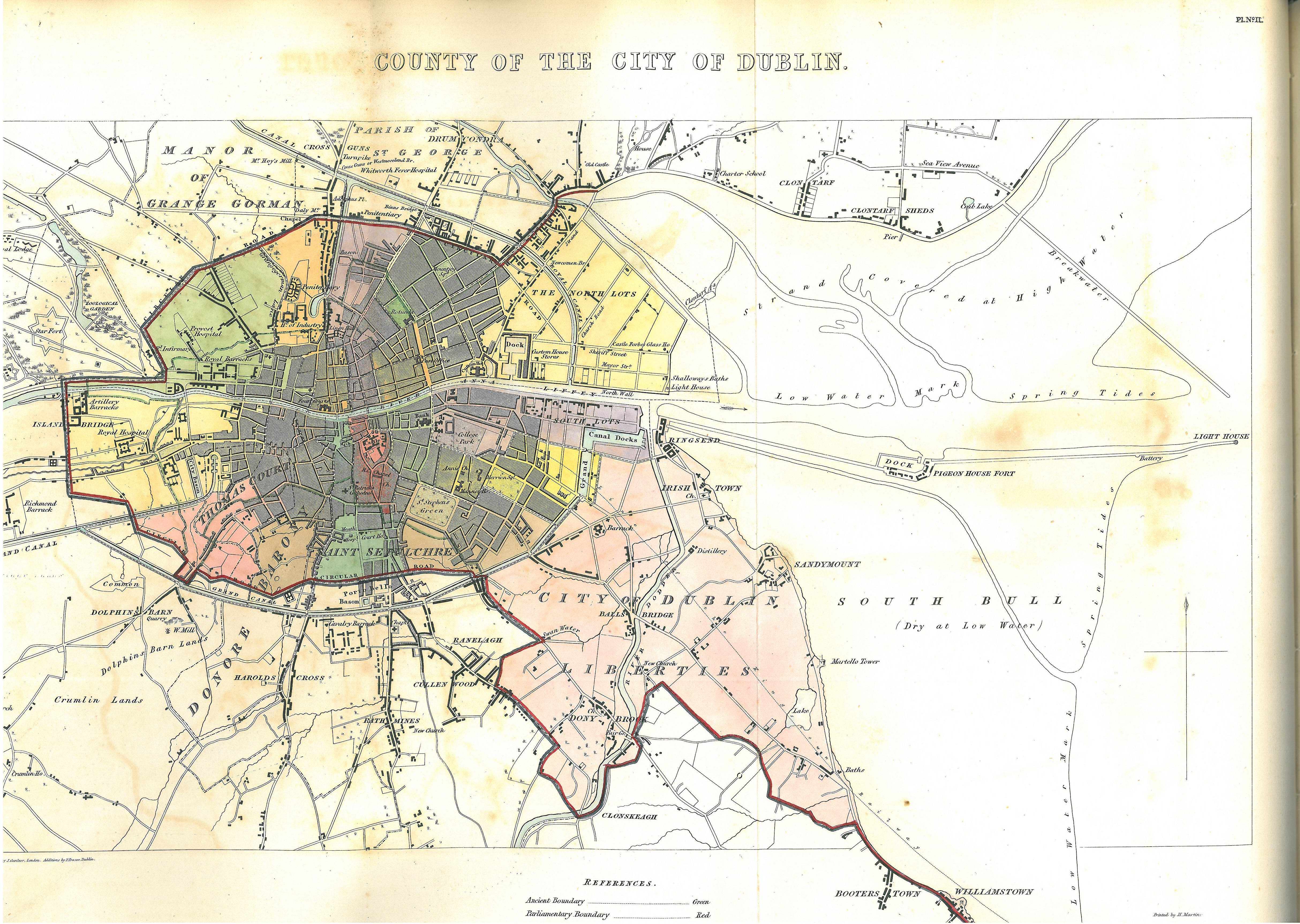
[Limits of.] (p.302-3; Heading "MANOR OF GLASS~NEVIN, or GRANGE~GORMAN") This manor comprehends a considerable portion of the modern city of Dublin. By a return from the register it is stated to contain,
- to the north of the river Liffey,
- the whole of the wealthy and populous parish of St. George (including within it Mountjoy Square and several of the adjacent streets) as far as the north side of Frederick Street, Great Britain Street, from the Rotunda, and the north side of Summer Hill;
- the parish of Grange Gorman, within which are Grange Gorman Lane, Manor Street, Prussia Street, Aughrim Street,
- the populous village of Phibsborough, which may be considered a part of the city itself,
- and the parish of Glassnevin.
- Its limits are also said to extend over the barony of Coolock, which comprehends the villages of Howth, Baldoyle, Raheny, Artane, Clontarf, Richmond, Drumcondra, Santry, Cloughran, and St. Margaret's, many of which are very populous;
- the barony of Castleknock, containing the village of Blanchardstown and parish of Castleknock, Barberstown,
- and, to the south of the river, the important villages of Kingstown, Killiney, Dalkey, Stillorgan, and other places of minor note as far as Bray, all in the barony of Rathdown, are alleged by the seneschal to be included, and jurisdiction is exercised over them;
- and, in addition to this extensive district, extending six or seven miles to the north of Dublin, and nearly ten miles to the south, over which the jurisdiction of the manor court is stated to have been actually exercised from time immemorial, it is considered by the seneschal that the jurisdiction, although not claimed, includes the city of Dublin itself.
We have not been able to obtain a copy of the charter, which, under the 20 sec. of the 27 Geo. III. c. 22, should be lodged with the clerk of the peace; but the seneschal informed us that the exact boundaries of the liberty are not laid down in the charter from which the jurisdiction is derived otherwise than as enumerating the several manors included therein; the names having, he says, become obsolete, it would be difficult now to ascertain from them the precise limits of the ancient jurisdiction.
[Charter.] (p.303-4; The authority under which this jurisdiction is exercised is stated to be a Charter granted by King James I. (1603) to the then newly-incorporated body, the dean and chapter of the cathedral of Christchurch, who are lords of the manor of Glassnevin, and the other manors within the liberty. [later p.304-5 discusses Manor Count of Grange Gorman/Glassnevin; no mention of other manors]
This charter is alleged to contain inspeximuses of charters of Henry VIII., Mary, and Edward, granted to the prior and convent of the cathedral church of the Holy Trinity, to whom the present corporate body succeeded, and whose possessions they obtained on the Reformation; and to confirm all the former grants made to the convent.
"The Bishop of Kildare, who is [ex-officio or merely at present?] Dean of Christchurch" (p.304
To do[edit]
- 1832 parl boundary committee map has (I think) proposed parl bdy and co of city bdy — see if better example of same map online.
- Map 1837 with municipal etc borders
- Recheck 1774 and 1842 Acts
- Check 1646 Civil Survey
- Check 1831 Census parish and barony
- Check Donore from 1831 census
- Check 1841 and 1851 Census, should note boundary changes
- Check 1904 statutory rules on border changes
- Check 1846 Parl Gaz notes
- Check 1901 townland index parish and barony index and census results
- List townlands in each section in logainm
- Find an old map of Peter's and Kevin's to see which bits were where.
- Bairéad 2011[15] has a good summary and details of 19C maps showing Donore and Sepulchre baronies etc.
- "The Lands of St. Mary's Abbey, Dublin" C. Ó Conbhuí Proceedings of the Royal Irish Academy. Section C: Archaeology, Celtic Studies, History, Linguistics, Literature Vol. 62 (1961 - 1963), pp. 21-86
- OS 1838-47 town plan of Dublin seems to have pre-1840 parish and county boundaries, at least SW of St Patrick's. Though an odd plot is unmarked at 53-55 Patrick St, NW of Cathedral; Bairéad p.170 says it wws "the property of the Prebendary of Clonmethan"
- Court cases
- 1828 case pp 298-302 whether St Kevin's parish in the county owed minister's money after 1680 Union with St. Peter's parish in the City; LCI unclear what "Liberties of Dublin" meant, more discussion of administrative boundaries
- 1838 pp.70-71 whether "St. Catherine, City Liberty" and "St. Catherine, Thomas Court" were two parishes, or halves of one; 6 Anne c. 21 ss. 13-14 defined precisely, but same minister's mony question
More maps[edit]
- sdublincoco.maps.arcgis.com includes layers of southern halves of Duncan 1821 and Rocque 1760 below
- 1821 Map of the County of Dublin William Duncan (Oireachtas library PDF) baronies in colour with exclaves
- 1760 "An actual survey of the County of Dublin" John Rocque has contiguous baronies but fully detailed Ballymore-Eustace exclave but not smaller exclaves
Sources[edit]
- 13 & 14 George III c.34 (Irl.) sec.37 (1774)
- 1831 Census of Ireland
- 1841 Census > Dublin > Footnote alterations since 1831
- County Dublin Baronies Act 1838 (1 & 2 Victoria c.115) —
- it mentions Valuation of Lands (Ireland) Act 1836 ss. 51-52 6 & 7 William 4 c.84, which is for annexing enclaves
- but it really modifies for Dublin the provisions of Grand Jury (Ireland) Act 1836 s.175 (6 & 7 William 4 c.116) for subdividing/merging large/small baronies by reducing the min/max limits from 45/40K acres to 25/20K acres.
- barony article mentions both acts, ignores Dublin wrinkles
- I suspect name Valuation of Lands (Ireland) Act 1836 (used in "barony (Ireland)" article) is non-official; SLR 1874 repealed, and Short Titles Act 1896 does not include it
- Why does 1838 mention one 1836 while modifying another? Answer is
1838 1836 it shall and may be lawful for the Grand Jury of the County of Dublin any county by Presentment to divide any Barony or Half Barony of such County thereof into Two one or more Subdivisions, each whereof shall, for the purposes of this Act, and for all Purposes relating to the presenting, raising, and levying of Money for any Matter or Thing for which Presentment may be lawfully made by such Grand Jury, and for the Purposes of the said Survey and Valuation grand juries be deemed and taken to be a Barony or Half Barony as such Grand Jury shall present the same
- And/or, 1838 act still inadequate so 1842 act zapped it all
- County of Dublin (Boundaries of Baronies) Act 1842 (5 & 6 Victoria c.96)
- Baronies of County Dublin logainm.ie
- Cd.2071 General topographical index, Ireland, 1901 Alphabetical index to the parishes of Ireland
- Dublin ParishesA Topographical Dictionary of Ireland, 1837
- "Dublin; Divisions and Towns". Parliamentary Gazetteer of Ireland. Vol. Vol.2. 1846. p. 96.
{{cite book}}:|volume=has extra text (help) - Drew, Thomas (2nd Quarter, 1891). "Surroundings of the Cathedral Church of St. Patrick de Insula, Dublin". The Journal of the Royal Society of Antiquaries of Ireland. Fifth Series, Vol. 1 (6): 426–432. JSTOR 25507789.
{{cite journal}}: Check date values in:|date=(help) [includes map] - Otway-Ruthven, A.J. (1961). "The medieval church-lands of county Dublin". In Watt, J.A. (ed.). Medieval Studies presented to Aubrey Gwynn S.J. pp. 54–73.
- MacCotter, Paul (2013). "The church lands of the diocese of Dublin: reconstruction and history". In Duffy, Sean (ed.). Medieval Dublin. Vol. XIII. pp. 81–107.
Notes[edit]
- ^ a b c Brief sketches of the parishes of Booterstown and Donnybrook. 1860. p. 96.
- ^ Lewis 1837, "Lusk"
- ^ Rpt Comm Mun Corp Irl 1836 p.290
- ^ a b "HISTPOP.ORG - Browse > Census > Ireland > 1821 > Preliminary observations, enumeration abstract, appendix, Ireland, 1821 Page 14". Retrieved 10 May 2016.
{{cite web}}: no-break space character in|title=at position 121 (help) - ^ a b "HISTPOP.ORG - Browse > Census > Ireland > 1821 > Preliminary observations, enumeration abstract, appendix, Ireland, 1821 Page 18". Retrieved 10 May 2016.
{{cite web}}: no-break space character in|title=at position 121 (help) - ^ a b c d "Minister's Money". Irish Law Recorder: 298–302. 1828.
- ^ Abstract of 1831 Census, p.21 fn.t 7 August 1833, HC Papers 634
- ^ Lewis 1837, "Swords"
- ^ Otway‐Ruthven, Jocelyn. "Place‐names in Ireland" Irish Geography vol.2 no.2 (1950) pp.45-51: 49
- ^ Journals of the House of Commons of the Kingdom of Ireland. House of Commons. 1763. p. 458.
- ^ The Irish Law Recorder. 1828. p. 300.
- ^ A Report of the Case of the Rev. Arthur Smith Adamson Against the Inhabitants of Grange Gorman: Heard in the Council Chamber at the Castle on the 8th, 14th, and 19th November, 1831 Before the Lord Chancellor and Other Members of the Privy Council. Hodges and Smith. 1832. p. 25.
- ^ Lodge, John; Archdall, Mervyn (1789). The peerage of Ireland: or, A genealogical history of the present nobility of that kingdom. J. Moore. pp. 282, fn. Retrieved 27 November 2015.
- ^ "Parish of St Catherines". AN ACCOUNT OF THE PROPORTION OF EACH GRAND JURY PRESENTMENT PAYABLE BY EACH PARISH IN THE CITY OF DUBLIN, From the Year 1807 inclusive, to the 1st January 1821. Sessional papers. Vol. Vol.20 No.511. 14 May 1821. p. 7.
{{cite book}}:|volume=has extra text (help) - ^ Where were 'the Liberties'? Eoin C. Bairéad Dublin Historical Record Vol. 64, No. 2 (Autumn 2011), pp. 160-175 Published by: Old Dublin Society Stable URL: http://www.jstor.org/stable/23365126