
User:Pfly/Sandbox5
| xx River | |
|---|---|
| Lua error in Module:Location_map at line 411: Malformed coordinates value. | |
| Location | |
| Country | Canada |
| Province | British Columbia |
| District | Cassiar Land District |
| Physical characteristics | |
| Source | xxThree Sisters Range |
| • location | xxStikine Ranges |
| • coordinates | {{coord|x58|10|26|N|129|29|51|W|display=inline}}[3] |
| • elevation | {{convert|x2040|m|abbr=on}}[2] |
| Mouth | xxStikine River |
• location | xxGrand Canyon of the Stikine |
• coordinates | {{coord|x58|7|37|N|130|40|11|W|display=inline,title}}[1][2] |
• elevation | {{convert|x295|m|abbr=on}}[2] |
| Length | {{convert|x140|km|abbr=on}}[4] |
| Basin size | {{convert|x1833|km2|abbr=on}}[5] |
| Discharge | |
| • average | {{convert|x16.0|m3/s|cuft/s|abbr=on}}[5] |
| Basin features | |
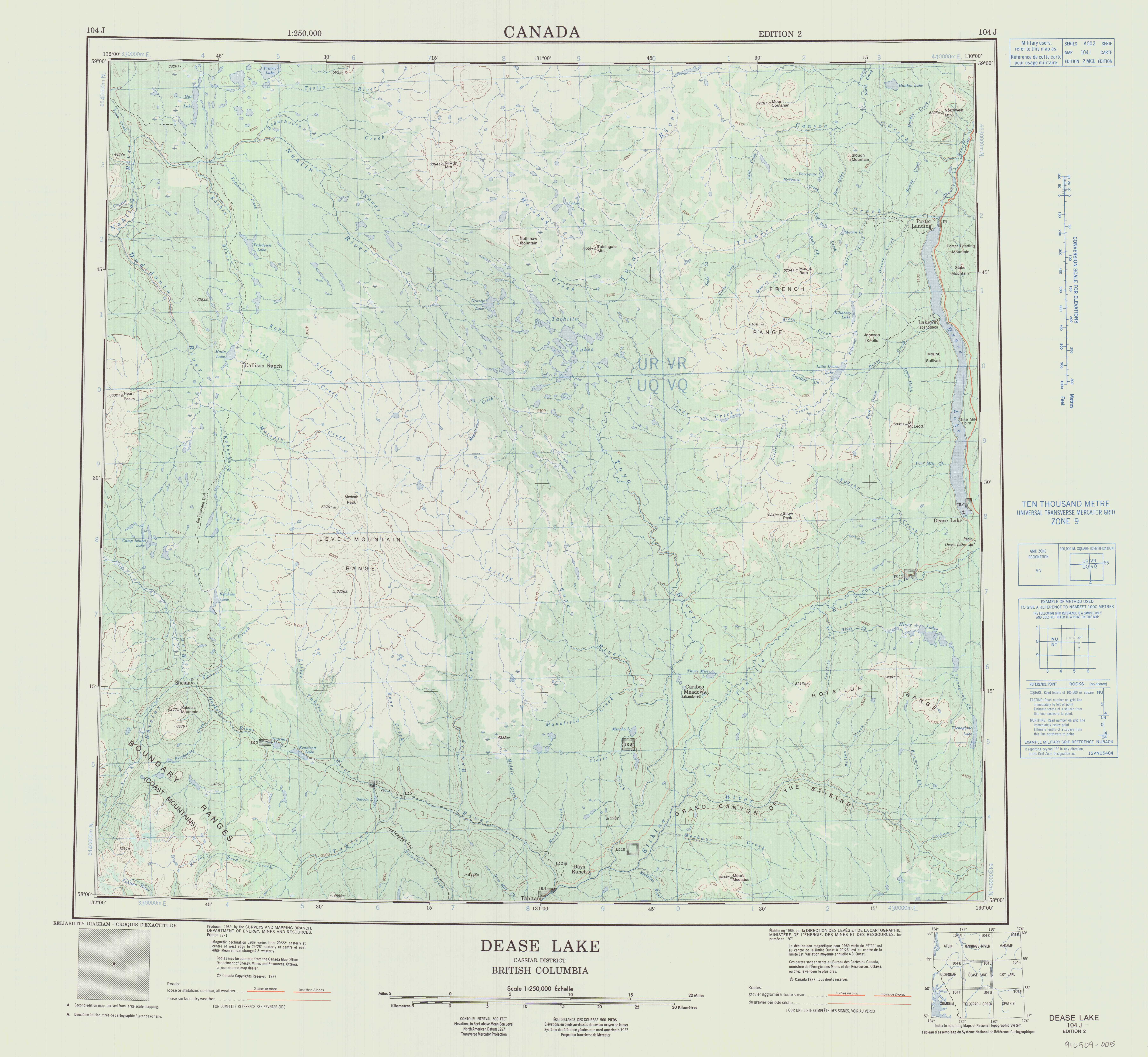
| Topo map | NTS 104J2 Classy Creek NTS 104J5 Ketchum Lake NTS 104J7 Little Tuya River NTS 104J8 Dease Lake |
The xx River is a tributary of
xxxthe Stikine River in northwest part of the province of British Columbia, Canada.[1]
xxxFrom its source in the Three Sisters Range the Tanzilla River flows roughly north and northwest to the vicinity of the community of Dease Lake, then turns west and southwest, flowing to the Stikine River in the Grand Canyon of the Stikine. The river's total length is roughly {{convert|x140|km|mi|abbr=on}}.[4] The Tanzilla River's mean annual discharge is estimated at {{convert|x16.0|m3/s|cuft/s|abbr=on}}.[5] Its watershed covers {{convert|x1833|km2|abbr=on}}.[5] The watershed's land cover is classified as xx28.8% conifer forest, xx27.3% shrubland, xx24.4% mixed forest, xx11.7% barren, xx5.2% herbaceous, and small amounts of other cover.[5]
xxThe mouth of the xx River is located about {{convert|x40|km|abbr=on}} northeast of the community of Telegraph Creek, British Columbia, about {{convert|x53|km|abbr=on}} southwest of Dease Lake, British Columbia, and about {{convert|x220|km|abbr=on}} east of Juneau, Alaska.
xxThe xxx River's watershed is within the traditional territory of the Tahltan First Nation, of the Tahltan people.[6][7]
Geography[edit]
xxxThe xx River originates in the Three Sisters Range, whence it flows northwest toward the community of Dease Lake. It receives the waters of numerous unnamed tributaries and a few named ones. Gnat Creek joins from the south,[8] then Zuback Creek from the east,[9] Tsenaglode Creek from the southwest,[10] and Dalby Creek from the east,[11] before the Tanzilla River nears Dease Lake and turns to the southwest.[2][12][13][5]
xxxAs the xx River nears Dease Lake its course is followed by the Stewart–Cassiar Highway, which goes to Dease Lake and beyond to the Yukon. Near Dease Lake the river flows by Tanzilla Butte and Tatsho Mountain.[14][15] After Dease Lake the Tanzilla River flows through wetlands in a meandering path, north of the Hotailuh Range.[16] Telegraph Creek Road, which connects the community of Telegraph Creek to the Stewart-Cassiar Highway, follows the Tanzilla River from Dease Lake to the Stikine River. As the Tanzilla flows west and southwest toward the Stikine and through the Tanzilla Plateau, it receives many tributaries including Tatsho Creek,[17] Sixteen Mile Creek,[18] Auguschidle Creek,[19] and Itsillitu Creek.[20][2][12][13][5]
xxThe lower xxx River also flows by the Tahltan Indian reserve "Tatcho Creek 11",[21] near the mouth of Tatsho Creek.[22] Near its mouth on the Stikine, the Tanzilla River passes by the locality of Cariboo Meadows,[23] then enters Stikine River Provincial Park before emptying into the Stikine River in the Grand Canyon of the Stikine, just east of the mouth of the Tuya River.
See also[edit]
References[edit]
- ^ a b "Tanzilla River". BC Geographical Names.
- ^ a b c d e f "Toporama (on-line map and search)". Atlas of Canada. Natural Resources Canada. Retrieved 25 October 2023.
- ^ Derived from BCGNIS, topographic maps, and Toporama
- ^ a b Length measured using BCGNIS coordinates, topographic maps, and Toporama
- ^ a b c d e f g "Northwest Water Tool". BC Water Tool. GeoBC, Integrated Land Management Bureau, Ministry of Agriculture and Lands, Government of British Columbia. Retrieved 25 October 2023.
- ^ "Our Territory". Tahltan Central Government. Retrieved 25 October 2023.
- ^ "Dah Ki Mi — "Our House"". Tahltan Band Council. Retrieved 25 October 2023.
- ^ "Gnat Creek". BC Geographical Names.
- ^ "Zuback Creek". BC Geographical Names.
- ^ "senaglode Creek". BC Geographical Names.
- ^ "Dalby Creek". BC Geographical Names.
- ^ a b c Mussio, Russell; Mussio, Wesley (2018). Northern BC Backroad Mapbook. Mussio Ventures. p. 96. ISBN 978-1-926806-87-7. Retrieved 25 October 2023.
- ^ a b c Dease Lake, Cassiar District, British Columbia (Topographic map) (2 ed.). 1:250,000. A502 (in English and French). Ottawa, Ontario: Department of Energy, Mines and Resources. 1977. Archived from the original on 2021-05-02. Retrieved 22 October 2023.
- ^ "Tanzilla Butte". BC Geographical Names.
- ^ "Tatsho Mountain". BC Geographical Names.
- ^ "Hotailuh Range". BC Geographical Names.
- ^ "Tatsho Creek". BC Geographical Names.
- ^ "Sixteen Mile Creek". BC Geographical Names.
- ^ "Auguschidle Creek". BC Geographical Names.
- ^ "Itsillitu Creek". BC Geographical Names.
- ^ "Tatcho Creek 11". BC Geographical Names.
- ^ "Iskut 6 Indian Reserve". Crown–Indigenous Relations and Northern Affairs Canada. Government of Canada. Retrieved 28 October 2023.
- ^ "Cariboo Meadows". BC Geographical Names.
{{Rivers of Level Mountain}} {{authority control}} [[Category:Cassiar Land District]] [[Category:Level Mountain]] [[Category:Rivers of British Columbia]] [[Category:Stikine Country]] [[Category:Tahltan]] [[Category:Taku]] [[Category:Tributaries of the Stikine River]] {{WikiProject Canada|geography=yes|bc=yes|class=stub|importance=low}} {{WikiProject Rivers|class=Stub|importance=Low}}