User:Tmaraki/User:Tmaraki/The Enchantments
| Tmaraki/User:Tmaraki/The Enchantments | |
|---|---|
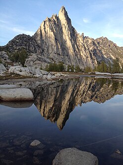
 View of Prusik Peak from Gnome Tarn | |
| Floor elevation | 7,428 ft (2,264 m)[1] |
| Length | 5 mi (8.0 km) |
| Depth | 1,400 ft (430 m) |
| Geography | |
| Country | United States |
| State | Washington |
| District | Alpine Lakes Wilderness |
| Coordinates | 47°28′52″N 120°48′14″W / 47.48111°N 120.80389°W [1] |
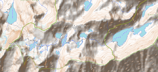
| Topo map | USGS Enchantment Lakes |
The Enchantments is a region consisting of upper and lower basins, meadows and glacier lakes surrounded by the peaks of Stuart Range in the Alpine Lakes Wilderness area of Washington's Cascade Mountain Range.[2] Located about 15 miles (24km) southwest of Leavenworth, Washington in the United States, The Enchantments is regarded as one of the most spectacular locations in the Cascade Range. [2] Nestled in the 4-million acre Okanogan-Wenatchee National Forest, The Enchantments live at an elevation of 4,500 feet (1,372 m) with the highest peak, Dragontail Peak, being 8,840 feet (2,694 m).[3] The vast peaks and gorgeous views make this a prime area for many climbers, backpackers and mountaineers of the Pacific Northwest. Renowned mountaineering climber, Fred Beckey was the first to summit one of the many peaks in the region, naming the cluster of isolating spear-like mountains Cashmere Crags.[4][5]
Historically, Native Americans have lived in the area, and traveled the region before it was ever discovered by Western civilization. By the early 1900s, logging and mining had consumed much of the area.[6] The region was named by European American topographer, A.H. Sylvester, who worked for the US Geological Survey in the Snoqualmie Ranger District from 1897 to 1907.[7] During his time as Wenatchee Forest district supervisor from 1908 to 1931, Sylvester had discovered the unmapped and unexplored area. In a letter, he had described the area writing, "It was an enchanting scene. I named the group Enchantment Lakes."[7] Later, Bill and Peg Stark would visit The Enchantments and name the many landmarks with mystical and spiritual type names: Nada Lake, Gnome Tarn, High Priest, and Lost World Plateau.[7]
Conservation efforts for public wilderness lands were strongly impacted by The Wilderness Society founded in 1935. [8] Their efforts, along with many other organizations, had resulted in the Wilderness Act of 1964 to pass legislation.[8] The act had established a National Wilderness Preservation System to preserve and protect certain lands, leaving them "unimpaired for future use and enjoyment as wilderness, and so as to provide for the protection of these areas, the preservation of their wilderness character."[9] Due to the population increase in Western Washington, the Alpine Lakes had seen high usage that resulted in negative and some permanent impacts to the fragile ecosystems of the region, most especially within The Enchantments.[2] The sensitive ecosystems that survive the great elevations and intense weather patterns, rely on minimal nutrients to survive. With the popular peaks attracting more and more foot traffic, destruction of landscape became a serious issue.[2] Although the Wilderness Act had set certain precautions for protection of the lands, studies and data conducted by the Alpine Lakes Protection Society (ALPS) proved the destructive overuse of the Alpine Lakes region. [10] In an effort to regulate the number of backpackers on The Enchantment trails without further disrupting ecosystems, and to maintain compliance with the Wilderness Act, ALPS proposed an overnight permit system. In 2019, the system was approved and implemented by the Okanogan-Wenatchee National Forest (OWNF).[10]
History[edit]

The first European American to reach the area and name it was A.H. Sylvester, topographer for the US Geological Survey and first supervisor of the Wenatchee National Forest.[11] Sylvester visited the middle Enchantment basin and probably did not venture into the upper basin. Snow Creek Glacier covered more of the upper basin at the time than it does today, which may have discouraged him from exploring the higher areas.[12] He is credited with naming some of the features in the region.
By the 1940s climbers reached the area and began naming the crags. Bill and Peg Stark, of Leavenworth, became frequent visitors who drew upon various mythologies to name features of the landscape. When they made their first visit in the fall of 1959, they were captivated by the golden splendor of the larch trees in the fall, the numerous lakes and tarns, and jagged peaks towering above. They used fairy names such as Gnome Tarn, Troll Sink, Naiad Lake (officially Temple Lake), Sprite and King Arthur legends in the Lower Enchantment Basin because "the lower basin was not as austere as the upper basin," according to Peg. They used Norse names and mythology for features of the upper basin, for example Lake Brynhild (officially Isolation Lake), Lake Freya (officially Tranquil Lake), and Valhalla Cirque because, Peg said, it felt "as if the Ice Age had just gone off."[13]
The official naming rulings of the US Board on Geographic Names in the 1960s resulted in a mixture of two name sets being adopted as official, particularly for the lakes, but also exemplified by the feature popularly known as Aasgard Pass being officially designated Colchuck Pass. Different sources still use the unofficial names in some contexts. The current policy of not adopting new names for geographic features in wilderness areas probably precludes the rest of the names identified by the Starks from achieving official status.
The number of visitors to the Enchantments grew to large numbers partly due to the fast-growing population of Seattle. By the late 1970s up to 300 people camped in the basin on summer weekends, leaving trash, creating unauthorized paths, and trampling the heather. The Forest Service installed toilets in 1966, restricted horses in 1972, and banned dogs in 1982. In 1987 the Forest Service enacted a permit system for overnight camping in the Enchantments and the Snow Lakes, Stuart Lake, and Colchuck Lake areas.[14]
Conservation[edit]
The Alpine Lakes Wilderness consists of a wide variety of plants and trees, such as Douglass fir, western red cedar, noble fir, vine maple, and alder, due to differentiations in precipitation and elevation. [2]The high, rocky alpine and subalpine meadows at great elevations make the ecosystems highly sensitive to the natural elements for survival and nutrition. [15] Concerns to preserve and protect the vegetation and habitats of the area have grown rapidly. With over 100,000 visitors annually as of 2019, the heavy foot traffic has outgrown the terms of the 1964 Wilderness Act in which U.S. Wilderness areas are "where the earth and its community of life are untrammeled by man, where man himself is a visitor who does not remain". [9][2] Vegetation at high elevation levels are particularly vulnerable to foot traffic due to their short growing season, sparsity and low resilience to changes in environment, such as global warming.[15] Unsuccessful maintenance of the area had failed to address impacts such as "degradation and loss of meadow, riparian damage, tree damage, presence of dog and human waste, widening and braiding of trails and compaction of sites and soils." [2] In 2016, the ALPS proposed a permit-system to regulate the number of hikers and prevent further landscape destruction, and in October 2018, after much data collection, the OWNF approved the permit system effective in 2019.[10]
The Alpine Lakes Protection Society (ALPS) is one of the biggest advocates for conserving the natural elements and features of the lakes that exist within The Enchantments, and its surrounding region. In the early 1900s when logging and mining had taken over much of the back country, the ALPS was formed as a result of the pressure from the people to find ways to save the beloved region. Founded in 1968, it has promoted congressional enactment in the Cascade Mountains region, protecting the area from any actions that would impact the "wilderness quality" of the Alpine Lakes region.[6] In 1976, Congress designated 362,789 acres to the Alpine Lakes Wilderness.[16]
In 2016, Chelan County and the Washington State Department of Ecology had proposed plans to enlarge dams and other water-related projects within the Enchanted Lakes region, calling it the Icicle Strategy.[17] The purpose of the plan was to improve stream flows and water availability into the Icicle Creek Subbasin. [18] The plan would increase the dam on Eightmile Lake and on Upper and Lower Snow Lakes which could not only cause flooding in the lakes, but also the surrounding area.[18] In 2018 the plan was formally adopted. Although there were concerns relating to the habitats and recreation of the areas within The Enchantments, the plan was reviewed by the State of Washington's Department of Ecology who thoroughly weighed the positive impacts against concerns; the habitat protection, fish passage, fish screening and water conservation efficiencies. [19]
Hiking[edit]

There are two primary approaches to the Enchantments Basin. Both trail heads are accessed via Icicle Creek Road. The Snow Lakes trailhead is off Icicle Creek Road at a large parking lot next to the creek. The trail climbs 6.5 miles (10.5 km) to Snow Lakes gaining 4,100 feet (1,200 m). From Snow Lakes the trail ascends over sloping granite rock to the Lower Enchantments. The entire hike is 9 miles (14 km) one-way, with 6,000 feet (1,800 m) of elevation gain to an end elevation of 7,800 feet (2,400 m).[3] This hike usually takes two days each way and is described as "long, steep, and grueling."[11] The alternate route is from the Stuart Lake trail head a couple of miles up Eightmile road off Icicle Creek Road. The trail up to Colchuck Lake is 4.75 miles (7.64 km) long and gains 2,100 feet (640 m); another 1.75 miles (2.82 km) bring hikers to the south end of the lake and Aasgard Pass, which climbs 2,200 feet (670 m) in 0.8 miles (1.3 km).[20] Aasgard Pass is a steep scramble which is dangerous to descend in snow.[21] The Aasgard Pass route has also been described as "in very bad taste" because it bypasses the beauty of the lower basin to get to the upper basin first.[20] The two routes can be combined to form a loop if the hiking party has two cars, a bicycle, or otherwise arranges transportation between the trail heads.
The United States Forest Service restricts access to the Enchantments permit area, which includes five zones. The three most popular zones are the Snow Zone (from Icicle Creek up to Snow Lakes), the Colchuck Zone (the area surrounding Colchuck Lake) and the Core Enchantment Zone (the Upper and Lower Enchantment Basins and surrounding peaks). The other zones are the Stuart Zone (the area around Stuart Lake and the northern approaches to Mount Stuart) and the Eightmile/Caroline Zone (Eightmile Lake, Eightmile Mountain, Cashmere Mountain, and vicinity). In addition, the Forest Service has proposed adding the Ingalls Lake, Headlight Basin, and Mount Stuart areas to the permit area in accordance with a 1993 NEPA decision. The earliest the change could be implemented is 2010.[22]

The 1981 Alpine Lakes Wilderness Plan established a quota of 60 people at one time as the carrying capacity of the Core Enchantment Zone. For overnight camping between May 15 and October 31 hikers in any of the five currently established zones must have permits. 75 percent of the permits for each hiking season are awarded in advance by lottery. The first round of the (very competitive) lottery includes all applications received between February 15, 2016 (12:01 a.m. PT) and March 2, 2016 (11:59 p.m. PT) for the 2016 season. All applications received during this period will be randomly drawn on or around March 6th.[23] The other 25 percent of permits are issued each morning (except Sunday) at 7:45 a.m. at the Leavenworth ranger station for trips beginning the same day. If not enough permits are available for the day's applicants, the permits are awarded by lottery.[22]
The Forest Service has banned dogs in the area, which has allowed the population of mountain goats and ptarmigan to recover.[24][11]
References[edit]
- ^ a b "Enchantment Basin". Geographic Names Information System. United States Geological Survey, United States Department of the Interior.
- ^ a b c d e f g "Alpine Lakes Wilderness". www.historylink.org. Retrieved 2020-10-16.
- ^ a b "Enchantment Lakes". Washington Trails Association.
- ^ "Fred Beckey and mountaineering partners explore ridges above Enchantment Lakes in June 1947". www.historylink.org. Retrieved 2020-10-16.
- ^ "Cashmere Mountain : Climbing, Hiking & Mountaineering : SummitPost". www.summitpost.org. Retrieved 2020-10-16.
- ^ a b Alpine Lakes Protection Society (1960–2011). "Alpine Lakes Protection Society records". University of Washington Libraries, Special Collections. Retrieved October 16, 2020.
{{cite web}}: CS1 maint: date format (link) CS1 maint: url-status (link) - ^ a b c Klippert, Jan P. (March 2006). "Hiking Place Names: The stories behind names in the backcountry" (PDF). Washington Trails Association. Retrieved October 16, 2020.
{{cite news}}: CS1 maint: url-status (link) - ^ a b "Wilderness Timeline | The Wilderness Society". www.wilderness.org. Retrieved 2020-10-16.
- ^ a b 88th Congress (September 3, 1964). "Wilderness Act" (PDF). U.S. Forest Service. Retrieved October 16, 2020.
{{cite web}}: CS1 maint: numeric names: authors list (link) CS1 maint: url-status (link) - ^ a b c Alpine Lakes Protection Society (February 2019). "USFS action regarding Enchantments overuse" (PDF). Alpine Lakes Protection Site. Retrieved October 16, 2020.
{{cite web}}: CS1 maint: url-status (link) - ^ a b c Spring, Ira; Manning, Harvey (1998). 100 Classic Hikes in Washington's Alpine Lakes (1st ed.). The Mountaineers. ISBN 0-89886-707-X.
- ^ Marler, Chester (2004). East of the Divide: Travels through the Eastern Slope of the North Cascades 1870-1999. North Fork Books. p. 50. ISBN 0975460501.
- ^ Sykes, Karen (October 8, 1998). "World-renowned basin in the Alpine Lakes Wilderness has a magical allure". Special to the Post-Intelligencer. Seattle Post-Intelligencer. Retrieved 2007-08-09.[dead link] Alt URL
- ^ Foster, David (September 7, 1989). "Rangers help control overcrowding as hikers try loving forests to death". The Bulletin (Bend). Retrieved 2014-09-19.
- ^ a b Hunter, Rebecca (2018-05-08). "Places of the Pacific: The Enchantments". Wildlands Network. Retrieved 2020-10-17.
- ^ USDA Forest Service. "Alpine Lakes Wilderness". USDA Forest Service. Retrieved October 16, 2020.
{{cite web}}: CS1 maint: url-status (link) - ^ "Speak Up for the Enchantments! — Washington Trails Association". www.wta.org. Retrieved 2020-10-17.
- ^ a b "Chelan County Natural Resources - Environmental Review". www.co.chelan.wa.us. Retrieved 2020-10-17.
- ^ "Icicle Creek strategy - Washington State Department of Ecology". ecology.wa.gov. Retrieved 2020-10-17.
- ^ a b Spring, Ira; Spring, Vicky; Manning, Harvey (2002). 100 Classic Hikes in Washington (3rd ed.). The Mountaineers. ISBN 0-89886-586-7.
- ^ Nelson, Jim; Potterfield, Peter (2003). Selected Climbs in the Cascades. Vol. 1 (2nd ed.). Mountaineers Books. p. 114.
- ^ a b "Enchantment Area Wilderness Permits". US Forest Service. 2009. Archived from the original on 2007-03-29. Retrieved 2009-10-05.
- ^ "Enchantment Permit Area, WA". Recreation.gov. Retrieved 2015-09-25.
- ^ Johnston, Greg (October 21, 2004). "A heavenly reward awaits in the Enchantment Lakes Basin". Seattle Post-Intelligencer. Retrieved 2007-08-09.
- Enchantment Lakes - Washington (Map). 1 : 24,000. 7,5 Minute Series (Topographic). United States Geological Survey. 1998. ISBN 0-607-58160-3.
- The Enchantments, WA – No 209S (Map). 1 : 44,500. Special Series. Green Trails, Inc. 2016.
External links[edit]
- Alpine Lakes Wilderness Permits for Enchantment Lakes from the US Forest Service, Wenatchee River Ranger District.
- U.S. Geological Survey Geographic Names Information System: Enchantment Basin
- Enchantment Lakes from the Washington Trails Association.
Category:Cascade Range Category:Protected areas of Chelan County, Washington Category:Wilderness Areas of Washington (state) Category:Wenatchee National Forest


