
User:William S. Saturn/Sandbox

Within its borders, the U.S. state of Texas contains seven distinct bay systems. These systems are made up of numerous inlets or extensions, which broaden the boundaries of the primary bay. The bays formed as ancestral river valleys that filled with seawater following the sea level rise approximately 10,000 years ago.[1] The current formations were established in the past 4,000 years as the sea levels stabilized. All Texas bays currently drain water from rivers and streams into the Gulf of Mexico, and can be classified as estuaries, although Laguna Madre, the state's largest bay, is considered an inverse estuary. The mixture of fresh and seawater in these systems serve as a habitat for diverse wildlife including several species of finfish, shellfish and a large collection of birds; notably the endangered Whooping Crane.
Human activity on the bays predates the Karankawa Indians who are generally associated with the Texas coast. The Karankawa were present during the European conquest but vanished by the mid-19th century. Several settlements were established on the coast including Galveston, Indianola and others. Some of these settlements were badly damaged by hurricanes and completely or nearly abandoned. The present-day cities of Houston, Corpus Christi, Port Lavaca and Rockport among others, were later established and continue to thrive. Oil drilling, tourism and the export and import of shipped goods are the mainstays of these local economies. The largest ports on these bays are the Port of Houston off Galveston Bay, Port of Corpus Christi on the bay of the same name and Aransas Pass on Aransas Bay. Notable tourist destinations include Port Isabel, Corpus Christi, Rockport, South Padre Island and Port Aransas.
All the bay systems in Texas with the exception of Sabine Lake, the smallest, are unique for being protected by barrier islands. This is especially true for Laguna Madre, which is protected by Padre Island, the longest barrier island in the world. Corpus Christi Bay is protected by Mustang Island, Aransas Bay is protected by San Jose Island, San Antonio Bay is protected by Matagorda Island, Matagorda Bay is protected by Matagorda Peninsula and Galveston Bay is protected by the Bolivar Peninsula and Galveston Island.
The following is a list of Texas bays. The color to the left on each table of bays and their extensions, corresponds to the color in the maps. The map to the right shows the seven different bay systems with seven different colors.
Aransas Bay[edit]
| Name | Location | Surface area | Average depth | Average salinity | Settlements | Major streams | |
|---|---|---|---|---|---|---|---|
| Aransas Bay | 28°02′06″N 97°00′10″W / 28.035016°N 97.002754°W | 208 square miles (540 km2) [2] | 9.8 feet (3.0 m) [2] | 15 ppt [2] | Rockport, Fulton, Aransas Pass | Aransas River, Mission River | |

| Name | Location | Notes | |
|---|---|---|---|
| Carlos Bay | 28°07′54″N 96°53′29″W / 28.131642°N 96.891518°W | ||
| Copano Bay | 28°07′08″N 97°06′16″W / 28.118925°N 97.104378°W | *Site of the ghost towns of Copano[3] and St. Mary's of Aransas.[4] *Nearly the size of the main bay.[5] | |
| Dunham Bay | 28°08′31″N 96°54′51″W / 28.141935°N 96.914177°W | ||
| Mesquite Bay | 28°08′19″N 96°50′35″W / 28.138605°N 96.843109°W | ||
| Mission Bay | 28°09′15″N 97°09′51″W / 28.154044°N 97.164116°W | *The mouth of Mission River.[5] *Copano Bay extension.[5] | |
| Port Bay | 28°00′33″N 97°09′11″W / 28.009255°N 97.15313°W | *Copano Bay extension.[5] | |
| Redfish Bay | 27°53′50″N 97°07′05″W / 27.897349°N 97.118111°W | *Contains the northernmost extensive beds of seagrass in Texas.[6] | |
| St. Charles Bay | 28°11′20″N 96°56′36″W / 28.188849°N 96.943359°W | *Located on the Aransas National Wildlife Refuge.[7] *Natural habitat of the Whooping Crane.[8] | |
| Sundown Bay | 28°10′48″N 96°51′39″W / 28.179922°N 96.86079°W | ||
Aransas Bay is found on the central Texas coast in Aransas County. It is oriented laterally northeast to southwest, and is extended by Redfish Bay to the southwest, Copano Bay to the west, Saint Charles Bay to the north, and Mesquite Bay to the northeast. The bay is separated from the Gulf of Mexico by San José Island and exchanges with the Gulf at Aransas Pass; the most direct navigable outlet from the bay.[5]
The Native American Aransas pre-Karankawa people (from whom the bay is named), settled in the area approximately 6,000 years ago. The Aransas disappeared around 1200 CE, and were replaced by the Karankawa two hundred years later. The Karankawa eventually died from European diseases or fled the area and were completely evacuated by the mid-19th century. European immigrant towns including Lamar and Aransas City were established during the 19th century but were largely abandoned by the 20th century. They were replaced by the present day cities of Rockport, Fulton and Aransas Pass. Resources such as shrimp, fish, oysters and oil sustain the economies on bay, as well as tourism, notably to Rockport where a beach is found on the shore, and to the popular fishing destination of Fulton.[9]
-
 Aerial photo of Aransas Bay and its extensions.
 -
 Rockport Beach on Aransas Bay.
 -
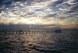
 Fishing piers on Aransas Bay.
 -
 Fulton Harbor in Fulton.
 -
 Fishing piers on Copano Bay.
 -
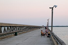 Copano Bay Fishing Pier beside the Copano Bay causeway.
 -
 Benthic Map of Redfish Bay.


Corpus Christi Bay[edit]
| Name | Location | Surface area | Average depth | Average salinity | Settlements | Major streams | |
|---|---|---|---|---|---|---|---|
| Corpus Christi Bay | 27°46′40″N 97°16′25″W / 27.777734°N 97.273636°W | 192 square miles (500 km2) [10] | 9.8 feet (3.0 m)[10] | 22 ppt[10] | Corpus Christi, Ingleside, Portland | Nueces River, Oso Creek | |


Corpus Christi Bay is located in San Patricio and Nueces counties, just south of the Aransas Bay system. It is separated from the Gulf of Mexico by Mustang Island, and is fed by the Nueces River and Oso Creek, which enter from the western and southern inlets, Nueces Bay and Oso Bay.
The bay was settled by both the Karankawa and pre-Karankawa people, who used the area near Oso Bay as a burial ground.[11] Several European settlements were established or planned near the Nueces River confluence but failed or were scrapped until the mid 19th century when Corpus Christi was established. Corpus Christi grew into a major city and port on the bay, and was followed by the smaller ports of Ingleside and Portland. As a natural estuary, the bay supports a diverse collection of wildlife, and is a prime location for birdwatching, and recreational fishing. Tourism is a main industry on the bay and is encouraged by the many attractions in the city of Corpus Christi. The bay's abundance of petroleum and natural gas fosters industry, and its strategic location on the Texas coast is ideal for military establishment.
Extensions[edit]


| Name | Location | Notes | |
|---|---|---|---|
| Nueces Bay | 27°51′36″N 97°25′33″W / 27.860022°N 97.425728°W |
| |
| Oso Bay | 27°41′15″N 97°18′45″W / 27.687404°N 97.312431°W |
| |
Galveston Bay[edit]
| Name | Location | Surface area | Average depth | Average salinity | Settlements | Major streams | |
|---|---|---|---|---|---|---|---|
| Galveston Bay | 29°33′05″N 94°56′53″W / 29.551359°N 94.947968°W | 1,399 sq. km [12] | 2.0 m[12] | 11 ppt[12] | Baytown, Houston, Galveston, Port Bolivar, Texas City | San Jacinto River, Trinity River | |


Extensions[edit]
| Feature | Coordinates | Notes | |
|---|---|---|---|
| Bastrop Bay | -95.18° N 29.10° W | ||
| Chocolate Bay | -95.15° N 29.19° W | ||
| Christmas Bay | -95.19° N 29.05° W | ||
| East Bay | -94.67° N 29.51° W | ||
| Jones Bay | |||
| Trinity Bay | -94.79° N 29.68° W | ||
| West Bay | -94.95° N 29.26° W | ||
Laguna Madre[edit]
| Coordinates | Surface area | Average depth | Average salinity | Streams | |||
|---|---|---|---|---|---|---|---|
| Laguna Madre |   |
27.54° N 97.29° W | 3,658 sq. km [13] | 1.1 m[13] | 36 ppt[13] | Los Olmos Creek | |
The Laguna Madre is a long shallow hypersaline bay along the western coast of the Gulf of Mexico in Nueces, Kenedy, Kleberg, Willacy and Cameron counties in Texas, United States. It is separated by the roughly 20-mile (32 km) long Saltillo Flats land bridge into Upper and Lower bays. The two are joined by the Intracoastal Waterway, which has been dredged through the bay. Cumulatively, Laguna Madre is approximately 130 miles (209 km) long, the length of Padre Island. The main extensions include, Baffin Bay in Upper Laguna Madre, Red Fish Bay just below the Saltillo Flats and South Bay (Texas) near the Mexican border.
The bay's ecosystem is protected by the Laguna Atascosa National Wildlife Refuge, the Padre Island National Seashore as well as the privately owned King Ranch. The human history predates the formation of the Laguna Madre, and settlements have been established at Port Isabel and Port Mansfield on the bay's shores.
Extensions[edit]
| Feature | Coordinates | Notes | |
|---|---|---|---|
| Alazan Bay | |||
| Baffin Bay | |||
| Cayo del Grullo | |||
| Laguna Salada | |||
| Red Fish Bay | |||
| South Bay | |||
Matagorda Bay[edit]
| Coordinates | Surface area | Average depth | Average salinity | Streams | |||
|---|---|---|---|---|---|---|---|
| Matagorda Bay | 
|
28.50° N 96.50° W | 1,093 sq. km [14] | 2.0 m[14] | 19 ppt[14] | Colorado River, Lavaca River, Tres Palacios Creek | |
Matagorda Bay is a large estuary bay on the Texas coast, lying in Calhoun and Matagorda counties and located approximately 80 miles northeast of Corpus Christi, 143 miles southeast of San Antonio, 108 miles southwest of Houston, and 167 miles southeast of Austin. It is separated from the Gulf of Mexico by Matagorda Peninsula and serves as the mouth of numerous streams, most notably the Lavaca and Colorado Rivers. The major Texas seaport of Port Lavaca is located on the system's northwestern extension of Lavaca Bay. The city of Palacios is found on northeastern extension of Tres Palacios Bay, and Port O'Connor is located on the southwestern tip of the main bay's shore. The ghost town of Indianola, which was a major port before it was destroyed by two hurricanes in the late 19th Century, is also found on the bay.
The bay's shore, especially near the Colorado River delta, provides a habitat for a wide variety of wildlife. The wildlife serves as a basis for the birding and fishing tourism, and is an essential component of the production of seafood, specifically shrimp and blue crab, which are the specialties of the area. The fertile land near the bay is ideal for farming, especially for the propagation of rice.
Extensions[edit]
| Feature | Coordinates | Notes | |
|---|---|---|---|
| Carancahua Bay | |||
| Chocolate Bay | |||
| East Matagorda Bay | |||
| Keller Bay | |||
| Lavaca Bay | |||
| Tres Palacios Bay | |||
| Turtle Bay | |||
Sabine Lake[edit]
| Coordinates | Surface area | Average depth | Average salinity | Streams | |||
|---|---|---|---|---|---|---|---|
| Sabine Lake | 29.93° N 93.88° W | 243 sq. km. [15] | 2.0 m[15] | 11 ppt[15] | Neches River, Sabine River | ||
Extensions[edit]
No major Extensions
San Antonio Bay[edit]
| Coordinates | Surface area | Average depth | Average salinity | Streams | |||
|---|---|---|---|---|---|---|---|
| San Antonio Bay | 
|
28.41° N 96.72° W | 531 sq. km. [16] | 2.0 m[16] | 13 ppt[16] | Guadalupe River, San Antonio River | |
San Antonio Bay is a bay on the Texas Gulf coast situated between Matagorda and Aransas Bay. It consists mainly of the combined waters of the San Antonio and Guadalupe rivers, and is located at the mouth of the Guadalupe River, about 55 miles (89 km) northeast of Corpus Christi and 130 miles (209 km) southeast of San Antonio. It is protected from the Gulf of Mexico by Matagorda Island, leaving only relatively small and distant outlets to the Gulf for little mixing of bay and Gulf waters. The remoteness of the bay has prevented the establishment of major ports as seen on Aransas and Corpus Christi Bay, to the south.
The Aransas National Wildlife Refuge is found on the southwest portion of the bay. The diverse wildlife on these shores make up for the lack of a sizable human settlement.
Extensions[edit]
| Feature | Coordinates | Notes | |
|---|---|---|---|
| Ayres Bay | |||
| Espiritu Santo Bay | |||
| Guadalupe Bay | |||
| Hynes Bay | |||
| Mission Lake | |||
| Pringle Lake | |||
References[edit]
- General
- Specific
- ^ "Natural Setting". Texas Beyond History. The University of Texas. March 2009. Retrieved 14 August 2010.
- ^ a b c "Aransas Bay". GulfBase. Texas A&M University-Corpus Christi: Harte Research Institute for Gulf of Mexico Studies. Retrieved 9 January 2010.
- ^ Benowitz, June Melby. "Copano, Texas". Handbook of Texas Online. Texas State Historical Association. Retrieved 15 August 2010.
- ^ Huson, Hobart (May 30, 2010). "St. Mary's of Aransas, Texas". Handbook of Texas Online. Texas State Historical Association. Retrieved 15 August 2010.
- ^ a b c d e "Topographic Maps". Digital-Topo-Maps.com. Google. Retrieved 15 August 2010.
- ^ "Redfish Bay State Scientific Area". Texas Parks and Wildlife Department. February 9, 2007. Retrieved 15 August 2010.
- ^ Kleiner, Diana J. (May 30, 2010). "Aransas National Wildlife Refuge". Handbook of Texas Online. Texas State Historical Association. Retrieved 15 August 2010.
- ^ "St. Charles Bay". GulfBase. Texas A&M University-Corpus Christi. 2010. Retrieved 15 August 2010.
- ^ Long, Christopher (November 11, 2009). "Aransas County". Handbook of Texas Online. Texas State Historical Association. Retrieved 15 August 2010.
- ^ a b c "Corpus Christi Bay". GulfBase. Texas A&M University-Corpus Christi: Harte Research Institute for Gulf of Mexico Studies. Retrieved 1 June 2010.
- ^ Hester, Thomas R. (May 30, 2010). "Oso Creek Site". Handbook of Texas Online. Texas State Historical Association. Retrieved 16 August 2010.
- ^ a b c "Galveston Bay". GulfBase. Texas A&M University-Corpus Christi: Harte Research Institute for Gulf of Mexico Studies. Retrieved 15 July 2010.
- ^ a b c "Laguna Madre". GulfBase. Texas A&M University-Corpus Christi: Harte Research Institute for Gulf of Mexico Studies. Retrieved 5 June 2010.
- ^ a b c "Matagorda Bay". GulfBase. Texas A&M University-Corpus Christi: Harte Research Institute for Gulf of Mexico Studies. Retrieved 17 May 2010.
- ^ a b c "Sabine Lake and Estuary". GulfBase. Texas A&M University-Corpus Christi: Harte Research Institute for Gulf of Mexico Studies. Retrieved 15 July 2010.
- ^ a b c "San Antonio Bay". GulfBase. Texas A&M University-Corpus Christi: Harte Research Institute for Gulf of Mexico Studie. Retrieved 21 March 2010.