
User talk:Skookum1/Archive 5
| This is an archive of past discussions. Do not edit the contents of this page. If you wish to start a new discussion or revive an old one, please do so on the current talk page. |
| Archive 1 | ← | Archive 3 | Archive 4 | Archive 5 | Archive 6 | Archive 7 | → | Archive 10 |
alvo von alvensleben
did you confirm if J v Ribbentrop visited Wigwam inn. where did you get your stylized sasquatch image?
user: sfsorrow —Preceding unsigned comment added by 24.81.77.4 (talk) 23:46, 3 March 2008 (UTC)
Gee that's a really good question; the book that I have in the refs section had a bit of a guest roster of the Alvensleben's social whirl, including Germans on the Grand Tour, but I don't recall von Ribbentrop's name being there; I'm sure I would have noticed it, and the authors of the section would have commented on it as of note if his name had come up. But it's quite conceivable that if actual records of his visit exist they'd either be in the social register in town of the day, in the span of years that were the Alvensleben's heyday that is, or some gossip column spin-off from it, or it's possible that the Wigwam Inn's ledger/guestbook and memorabilia are in one of the local archives or museums, I'm sorry I wouldn't have a clue which one, first guesses are Vancouver or North Vancouver archives....But surely an interesting question; there was more in Maj. Matthews' Early Vancouver but don't have a copy any more and it's not indexed anyway (and so really hard to find things in....). Thanks for asking; if you really want to find out I suggest you start poking around the various BC archive sites to find the Wigwam's records, if they were salvaged that is; fascinating document of the day, no doubt, has me wondering about the major hotel registers also - and those, if they exist, quite likely would have von Ribbentrop in them if he rolled through town at all; most likely the Old Hotel Vancouver or its predecessor the First Hotel Vancouver (might not have an article); maybe the Hotel Georgia, though, which is where the British royals stayed when they were in town (if it existed by the time of his visit, which it may not have...); he was nobility and I would expect stayed in a hotel if in the city; though doubtless the von Alvenslebens had some nice mansions in the city as well....that's an interesting subject, their street addresses could definitely be somewhere, even pictures of the house....hmmmm. Thanks for the question; I'll post a link to this on Talk:Werner von Alvenseben. "sfsorrow" - you'd in san francisco or is that a reference to science fiction?Skookum1 (talk) 04:03, 4 March 2008 (UTC)
- OK now I'm confused; I know there was a Hugo (as named in one of the Vancouver histories which mention them, I think Morley's Vancouver:From Milltown to Metropolis, though only in brief) and the name Alvo comes up (a nickname?) also; so Gustav Konstantin von Alvensleben is yet another apple on the tree, and I suspect is notable at least within Vancouver history, though it woulld take some digging I don't have the resources on hand to write that portion of his story up; if you know much about the von Alvenslebens could you maybe write a short bio, and I'll see who/waht I can dig up about his business and social career in Vancouver....a long project, but interesting. Or maybe you're only interested in von Ribbentrop, that's OK; I'd be interested to know if he did stay at the Wigwam, and where he stayed in the city also, if he was there; could well have been, Vancouver was a port-of-call in teh around-the-world tour, especially for Germans who were nearly as prominent as Scots in Vancouver society; a jumping off point for the Klondike; if you know von Ribbentrop went to Dawson City, it's pretty much a given that he dropped by Vancouver, most probably as his diembarkation point for hte Inside Passage to the Yukon Ports; possibly Seattle as well.Skookum1 (talk) 04:12, 4 March 2008 (UTC)
skook. To clarify, Count Constantine Gustav Alvo von Alvensleben and Alvo von Alvensleben are one and the same. He being one of these
people with triple barrelled names, I have seen his name mentioned more times as Alvo v. Alvensleben, but several times as Constantine
Alvensleben. —Preceding unsigned comment added by 24.81.77.4 (talk) 00:53, 7 April 2008 (UTC)
re the sasquatch image: a photo I took of the side of a school bus shelter in Seton Portage; a First Nations community, but the art style is coastal and done by a guy from the Coast who'd been living there (it's in a remote valley in the Interior).Skookum1 (talk) 05:02, 4 March 2008 (UTC)
Hey Skookum One, interesting tidbits on Ribbentrop and von Alvensleben. I know a bit about Alvensleben and picking up more. Ribbentrop was in Vancouver in the 1912-14 era, he was not aristocratic (he bought the von bit) and was quite poor while here: he laboured on the Quebec Bridge, and in a BC logging camp too. I am learning more about Ribbentrop too, (Total Idiot he was) I just wanted to confirm the Wigwam Inn bit. Details are vague and records few. Ribbentrop did not go to Yukon. Alvensleben did go to Stewart as he had investments there. Sebastian Faulks Sorrow is a nom du net, you can wiki it. also wiki Coalmont,BC, to contact. —Preceding unsigned comment added by 24.81.77.4 (talk) 23:08, 5 March 2008 (UTC) I tried wiki'ing your name, i.e. searching for it in wiki, nothing; is it your user name? I googled it - is that you? Interesting if so; I've "went through" Jaynes a long time ago, so to speak....Coalmont, huh? Is that where you live? Looked up the Wiki article thinking you might be on its talkpage or whatever; what's the Coalmont connection. As for Ribbentrop and Wigwam, perhaps he wasn't a guest if he wasn't aristocratic but only a grunt; maybe he was staff - ?? A bio of the Alvensleben Bros. career in Vancouver would be a worthy research/book project, y'know....if you're in Coalmont chances are the Princeton Library has a copy of Strangers Entertained - the Wells Library had it, but then again Wells is kind of a special place. If you're in that area you must know about the Richters - ?Skookum1 (talk) 05:37, 6 March 2008 (UTC)
Skookum One-- no I am not in coalmont, slightly west. It is a place I hang and I only wrote the article on it and a few others, and Texada, and Narrow gauge in BC, and CN Bridge and on and on. Articles, it seems,that you also edited . try S. F. Sorrow. Never been to Wells, tho I am writing a bunch on Barkerville. cheers —Preceding unsigned comment added by 24.81.77.4 (talk) 16:22, 6 March 2008 (UTC)
My grandfather Marshall Latham Bond was a coinvestor with Alvo von Alvensleben in various projects before World War I. He was then the arresting officer when Alvo was interned during World War I. Afterwards they became friends again. Ribbentrop worked as company clerk secretary for Cassiar Mining a joint investment of Bond and Alvo's in which Canadian, American, British as well as Austrians and Germans were involved. RichardBond (talk) 00:02, 27 September 2008 (UTC)
Whatcom Trail
Hey, I just noticed that this article claims the trail is named for a Nooksack chief, but as far as I know, "Whatcom" is the Lummi word for "noisy waters", used for Whatcom Creek. Do you have a source that names a Nooksack chief as "Whatcom"? Cheers! Murderbike 21:58, 30 November 2007 (UTC)
- Absolutely best person to ask would be asking at Talk:Lummi or Talk:Nooksack (tribe) - oh, but that's you, Murderbike...best to ask a linguist, perhaps, or someone who has Galloway's book, I'm not at all familiar with Washington-side naming lore; it's hard enough on the BC side sometimes. Sorry.Skookum1 19:37, 2 December 2007 (UTC)My grandfather Marshall Latham Bond was a coinvestor with Alvo von Alvensleben in various projests before World War I. He was then the arresting officer when Alvo was interned during World War I. Afterwards they became friends again. Ribbentrop worked as company clerk secretary for Cassiar Mining a joint investment of Bond and Alvo's in which Canadian, American, British as well as Austrians and Germans were involved.
Big Raven Plateau
What Does the book "Notes from a Century Before" by Hoagland say about it sfs —Preceding unsigned comment added by 24.81.77.4 (talk) 17:03, 8 April 2008 (UTC)
As far as I know it Mount Edziza, that is what the people up there call it. I only got as far as Bell Irving bridge. Never been to the Spatsizi. Wild Country. sfsorrow
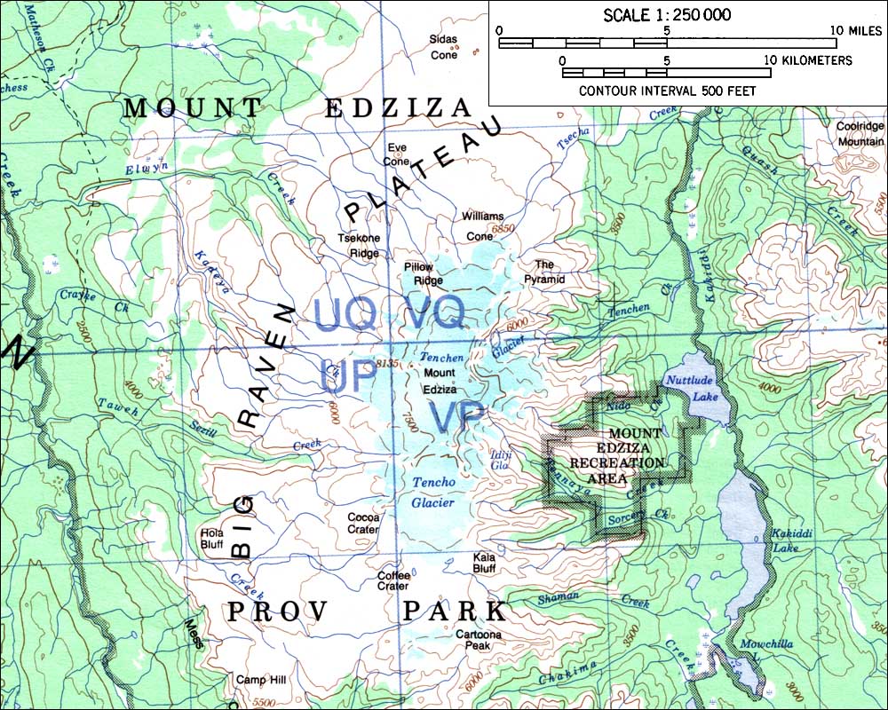
Hi Skookum1. Do you know if the Big Raven Plateau is the offical name for the Edziza Plateau? Black Tusk 03:23, 13 December 2007 (UTC)
According to the BC gov Land and Data Resource Warehouse Catalogue (LDRWC), it's only the western part of the Edziza volcano/plateau north of Sezill Creek. I think if you go find that Holland book I was talking about elsewhere you might find the Edziza Plateau formally described; if that's its name. The Big Raven Plateau would appear, by the conventions of Basemap/LDRWC, to be only a portion of it.Skookum1 (talk) 20:30, 14 December 2007 (UTC)
PS there is no use of "Edziza Plateau" in the LDRWC name-catalogue, which is the "official gazette". This doesn't mean the term doesn't appear in S. Holland, or in another geographic or geologic work.Skookum1 (talk) 20:31, 14 December 2007 (UTC)
- Ok. I just wanted to know because there's a map of the entire Mount Edziza Massive here. The western part of the the complex is called the Big Raven Plateau as well, but I thought they put it like that because of all the wording (i.e. Mount Edziza Prov Park, Mount Edziza Recreation Area, The Pyramid, Willams Cone, Mount Edziza, Cocca Crater, Pillow Ridge, etc). Black Tusk 00:29, December 2007 (UTC)
- Well, it would appear from that map that the plateau on the west-north flank of the volcano is the Big Raven; If there is such a thing as an Edziza Plateau I think it's just a larger area of the Tahltan Highland, or maybe the region of the Tahltan Highland south of the Stikine anyway...."plateau" refers to hilly/mountainous areas as well as "flat plateau" like the Big Raven; what I'm suggesting is the surrounding terrain may be the Edziza Plateau, but whether that term occurs in proper-name/capitalized form like that we still don't know; you may come across a proper cite for it (and by that I don't mean a tourism brochure...).Skookum1 (talk) 20:13, 15 December 2007 (UTC)
- Sorry about the spelling mistake (I don't use "massif" very often so I easily get confused). Is it possible the Edziza Plateau could be unnamed?
- Also, have you herd about the volcanic activity at Nazko Cone which began on October 9 or 10? I was a bit surprised when I herd about it. Black Tusk 20:23, 15 December 2007 (UTC)
LOTS of the BC landscape is unnamed; in the range of 10,000 peaks with 1000' prominence and various land features; "the plateau around Edziza" is the much more specific context as capitalizing "plateau" is incorrect, except in unofficial use; and maybe no one uses it. You might want to try emailing someone at any email address you can find for Eddontenajon or Telegraph Creek or Lower Iskut and just ask, see what they use; it may be Big Raven Plateau is all there is, at least in English; no doubt there are various names in Tahltan for features around there, but my experience with native languages is they don't name things the same way we do, ie. by category; places are "unique" in their names, the name is the story of the place, not a name given to it....hard to explain, easier to show...Skookum1 (talk) 23:31, 19 December 2007 (UTC)
Little context in Halalt First Nation
Hello, this is a message from an automated bot. A tag has been placed on Halalt First Nation, by another Wikipedia user, requesting that it be speedily deleted from Wikipedia. The tag claims that it should be speedily deleted because Halalt First Nation is very short providing little or no context to the reader. Please see Wikipedia:Stub for our minimum information standards for short articles.
To contest the tagging and request that administrators wait before possibly deleting Halalt First Nation, please affix the template {{hangon}} to the page, and put a note on its talk page. If the article has already been deleted, see the advice and instructions at WP:WMD. Feel free to contact the bot operator if you have any questions about this or any problems with this bot, bearing in mind that this bot is only informing you of the nomination for speedy deletion; it does not perform any nominations or deletions itself. To see the user who deleted the page, click here CSDWarnBot (talk) 21:01, 21 December 2007 (UTC)
Kanaka
Yeah - I was curious to see so many Kanakas in Siskiyou County as well. The only thing that I can think (guess), is that I know that a significant number of Hawaiians came to CA for the Gold Rush, but I don't know of any reason why they've have so many names in Siskiyou! NorCalHistory (talk) 00:34, 10 January 2008 (UTC)
- Well, most likely a settlement of them, or at least a family or two, as with the Kanaka Rancherie in Vancouver (aka the Cherry Orchard, now the West End shore of Lost Lagoon) or Kanaka Creek up the Fraser a bit, opposite Fort Langley; if gold rush-era maybe a mine claim that was worked by them, this was their camp; that's the thing with the date; or a group that decided to settle in and farm and ranch (haven't looked at the topo to see terrain; if in the bush most likely a mine, maybe an old fur camp, that's what I'm thinking; although HBC penetrations down that way tended mostly to be, SFAIK, French/Metis. In fur trade days it could have been some were killed there; the was there a Kanaka Cemetery? Siskiyou County Hall/Archives might be a good place to find something out the context of that name. Be interesting to know....and I hadn't realized the California Gold Rush went as far north as the Siskiyous (along the OR border right?); in BC the overall rush, also widespread, is broken down by area-name, y'see, Rock Creek, Cherryville, Princeton, Cayoosh, Cariboo, Fraser, Big Bend etc; they're not usually all see as only one; or is there a separate distinction in Cali between, say the Sierra Gold Rush and the [insert name] gold rush for another area, or does that terminology not occur?Skookum1 (talk) 20:31, 13 January 2008 (UTC)
List of Coast Salish Nations
I was inspired by a friend of yours to make this. It's not where near complete, but I'm using it as a tool to help guide me in what I need to accomplish in the whole scope of the northwest coast for my native folk. Either way, I realized there is no comprehensive list of Coast Salish tribes, either on it's page, or it's language page, although the language page will be helpful. I'm going to either add the list to the main Coast Salish page or created List of Coast Salish nations or List of Coast Salish tribes or List of Coast Salish. Then, as you can see in the template, there are a lot of articles needing creation so I'm going to get working on those eventually too. I've been learning more and more about the Treaty Process, and by extension, land claims. Then I want to find some friends of mine to explain the various court cases that don't define Aboriginal title. What was it what Guujaaw said? "One law for us, many laws for them." Either way, any points in a direction, probably off of Wikipeida, or to the library, would be greatly appreciated. OldManRivers (talk) 08:37, 16 January 2008 (UTC)
- At first glance I'm not sure about the use of the photo being normal in templates; flags, graphic logos etc I've seen, even maps; don't recall any photos per se. Also as this is a template for peoples pages, the government section at the bottom is definitely outre and maybe should be part of a template or List of governments for Pacific Northwest First Nations and Native American tribes The Coast Salish page is textbook-anthro in nature right now, and yeah a List of... is definitely needed as there are too many to be a section on that page; I'd think a table like the Ghosttowns one with separate columns could be useful, as the other columns could be used for which language(s) and which government(s) are for each people. List of Coast Salish peoples strikes me as the most useful, as List of Coast Salish could lead to confusion with the languages (NB Bella Coola are no longer considered Coast Salish by linguistics types; see Talk:Nuxalk and my exchanges with Bill Poser, who I don't think has ever forgiven me my impertinence; he's with the YKDLI in PG and he and his associates hvae written a lot of the northern ethno and language articles; you might want to try contacting him. List of Coast Salish tribes is a more American usage; unless you as a CanFN are comfortable with the term, over "nations" or "peoples". The use of "nation" in the encyclopedia (w/o "First" in front of it) is vague and shiftable and I don't recommend it; easier to choose "peoples" or "tribes". And keep the template just about the peoples, not the governments; List of articles on the history of Coast Salish peoples or something might suffice as an alternate to the History section of the template; just bear in mind you don't want the thing massively bloaty (see Oregon and the templates associated with History of Oregon, Oregon Treaty, and I've seen others which are also page-hogs. Economy is needed, esp. because of the huge list of peoples on the template already, even just within individual subsections; note the centreing I used on the templates previously; it's more aesthetic, although the design issues shift when you add an image/graphic as you've done. A map for the Coast Salish page seems also needed, dunnit? Ok, that's it for now...Skookum1 (talk) 20:45, 16 January 2008 (UTC)
The photo is something I just put there for now. I have the hardest time making maps. One day I'll learn. Thanks for the suggestions. There is definitely a lot of work to be done for all of the links included. Coast Salish is a priority, among others. OldManRivers (talk) 04:22, 18 January 2008 (UTC)
Also, if you want me to archive your talk page, just give me the word. OldManRivers (talk) 08:37, 16 January 2008 (UTC)
- Thanks pls do so, though leave a few recent entries including these.
I'm getting there!
Visit Sḵwxwú7mesh to see what I'm talking about. I think you will be pleased (I think, but then again, who knows). Suggestions, advice, compliments (hint, hint), and anything else would be appreciated. Pretty soon my people could become a series! Anyways, thought I'd let you know, well, since you kind of were one person who encouraged and inspired me to work on wikipeida more. later OldManRivers (talk) 10:03, 28 January 2008 (UTC)
Cypress Peak
Hi Skookum1. Do you know if Cypress Peak is volcanic in origin? I want to know because I'm uploading photos for some of the mountan/volcano articles (i.e. Mount Fee, Mount Cayley, Pyroclastic Peak, Mount Price). If you look at the photo here it's with the other volcanic peaks of the Mount Cayley volcanic complex. Black Tusk 06:23, 31 January 2008 (UTC)
- Seems to be a valley in between/ nothing to say it's not part of the same complex but there are other volcanoes north and east of there; and I've told you before I'm not a vulcanologist and have not studied detailed geological maps or geological studies of the region, despite my familiarity with its topography and history. Best you try to enlist someone from the Earth Geosciences Centre or whatever it's called as a resource person...joining bivouac.com might also turn up a resource person or two.Skookum1 (talk) 21:05, 31 January 2008 (UTC)
- I know you're not a volcanologist but you have told me stuff about other peaks that I didn't even know about, such as Mount Callaghan (I didn't know it was a volcano) and The Chasm. The other volcanoes around Mount Cayley (Mount Fee, Ring Mountain, Little Ring Mountain, Ember Ridge, Pali Dome, etc) seem related to the complex[1] (it's called the Mount Cayley volcanic field, but field and complex mean pretty much the same thing). I guess you could find out if Cypress Peak is volcanic by comparing it to the other volcanic peaks. The photo of Cypress Peak I linked above seems to have sand or ash at its base. I don't think non-volcanic peaks have that do they? I will probably upload some photos of Cypress Peak to the Mount Cayley volcanic complex article if I find out it's volcanic for sure. Black Tusk 22:23, 31 January 2008 (UTC)
Have a look, make suggestions, or maybe any copy editing if you feel up to it. I'm finally getting around to all the stuff I wanted to do. There is more writing I want to do, especially the history section with all the BCTP-related news. Like, who's against, who's for, why they are against, etc. Eventually a list of all the nations involved, and the stage they are at. Then I need to ad more on the Unity Protocol. But there is probably more I can think of, and either way, it'll probably come off as POV or bias so having others look at it would be cool. I alerted the Project British Columbia about it, and a few other wikipedia related friends. Thanks Skookum. Hope all is well with you. OldManRivers (talk) 17:35, 4 February 2008 (UTC)
Speedy deletion of Tsilhqot'in First Nations

A tag has been placed on Tsilhqot'in First Nations requesting that it be speedily deleted from Wikipedia. This has been done under section A3 of the criteria for speedy deletion, because it is an article with no content whatsoever, or whose contents consist only of external links, "See also" section, book reference, category tag, template tag, interwiki link, rephrasing of the title, or an attempt to contact the subject of the article. Please see Wikipedia:Stub for our minimum information standards for short articles. Also please note that articles must be on notable subjects and should provide references to reliable sources that verify their content.
If you think that this notice was placed here in error, you may contest the deletion by adding {{hangon}} to the top of the page (just below the existing speedy deletion or "db" tag), coupled with adding a note on the article's talk page explaining your position, but be aware that once tagged for speedy deletion, if the article meets the criterion it may be deleted without delay. Please do not remove the speedy deletion tag yourself, but don't hesitate to add information to the article that would would render it more in conformance with Wikipedia's policies and guidelines. Hennessey, Patrick (talk) 03:31, 9 February 2008 (UTC)
Speedy deletion of Template:Historical geographic regions of British Columbia
A tag has been placed on Template:Historical geographic regions of British Columbia requesting that it be speedily deleted from Wikipedia. This has been done under section T3 of the criteria for speedy deletion, because it is a deprecated or orphaned template. After seven days, if it is still unused and the speedy deletion tag has not been removed, the template will be deleted.
If the template is intended to be substituted, please feel free to remove the speedy deletion tag and please consider putting a note on the template's page indicating that it is substituted so as to avoid any future mistakes.
Thanks. --MZMcBride (talk) 06:53, 9 February 2008 (UTC)
Vancouver
Hi Skookum1, do you watch the WP Vancouver page? I'm looking for some feedback there. Thanks. Franamax (talk) 22:05, 9 February 2008 (UTC)
Speedy deletion of Template:Kwakwaka'wakw peoples
A tag has been placed on Template:Kwakwaka'wakw peoples requesting that it be speedily deleted from Wikipedia. This has been done under section T3 of the criteria for speedy deletion, because it is a deprecated or orphaned template. After seven days, if it is still unused and the speedy deletion tag has not been removed, the template will be deleted.
If the template is intended to be substituted, please feel free to remove the speedy deletion tag and please consider putting a note on the template's page indicating that it is substituted so as to avoid any future mistakes (<noinclude>{{tranclusionless}}</noinclude>).
Thanks. --MZMcBride (talk) 05:16, 10 February 2008 (UTC)
This where I start to get really biased. The Legwitok are the lowest ranking tribe of the Kwakwaka'wakw. (See Kwakwaka'wakw tribes). I imagine they fancy themselves as the top dog, but historically they were looked down upon among the rest of the nation (not just kwakwaka'wakw). Pirates, mostly. They didn't have any concept of the copper system, practically no treasures in the potlatch world. As for migration, it was the Northern tribes that pushed them downward, and naturally forced them to push the Coast Salish out. Indigenous colonization eh. It's quite interesting. I'm not in favor of turning a blind eye to some of the gritter history bits with indigenous peoples, just believe it should be done in a fair and honest way. Usually, when shit likes this starts to get big, White folk tend to start using it like it's a slice of bread. Latent racism I say. Never understood in context. It's like in highschool when some racist white kid said to the teacher, "But didn't they stop the potlatching because they were destroying everything and killing slaves." Well, that stuff only went on post-contact and right dead in the middle of colonization. The killing of slaves was rare and only done on the biggest of occasions. But they are quick to start throwing the arguments around, neglecting their own history, and what history is still being written (Oka, Aboriginal kids in care, missing women, and the other current forms of racism and prejudice, either overt in government or more subvert ways like when ever a child goes missing, if it's a white kid, everyones in a uproar, if it's a native kid, who gives a shit.) History, especially our harmful and negative pasts need to be respected and treated fairly. Doesn't mean we should forget or turn a blind eye, but remember for the next generations, build something better. This goes for all sides.
- Well, their neighbours certainly also thought they were pirates and they certainly behaved like that (as did other groups; Terry Glavin refers to the Lamalcha that they were the "bikers of the Gulf"), and I gathered at the time of reading that the Legwiltok story wasn't a heroic visoinary migration but a "it's too hot in the kitchen, let's go somewhere else to build/steal our barbeque" and that they were effectively driven out. It'salso typical of underdogs to pretend to the top dog role, I could think of other examples, and the braggy tone of the Weiwakai story in the AMNH book smacks of it big time. The mainstream Kwakwaka'wakw perspective that you're giving highlights the ironies; and it's dicety stuff considering the usual land claims about "since time immemorial"....and the fcant about getting along in harmony and such. Main point is that aboriginal political geoghraphy and politics wasn't static, as if things had stayed the same here since man first arrived, or came out of the ground, or whatever the story is. But don't get me wrong, it's not the gore/bloodhsed that's the point here, but that a chronology of wars and migrations could be worked out, and the context given without it being "bread for white people". About the latent radcism thing, it's not only your people who are subject o prejudicial interpretations of their history; my Norse forebears get a really bad rap as thugs, as if everybody else weren't. We were just bigger, well-dressed and better-equipped thugs; well, no, your typical Norseman had travelled half the known world, probabloy spoke six languages, dressed stylin' with stuf from Constantinople and Spain, and was more into statecraft and runnin' the farm than burning and pillaging and all the other fun stuff we're supposed to have been all about. Latent racism is also of the kind that says "white people can't understand the context", or "all white people are lazy and stupid and think in squre boxces" and such. But that's not a reason to deny them knowledge of, not the way things were in a fixed sense, but how they were changing and who used to be where and so forth; like sorting out the succession of states in the Hellenistic Levant or how Europe's boundaries slowly formed over the centuries(and got shoved back and forth). I see native history all the time that avoids mention of it as embarrasssment; it's only embarrassing if you allow it to be, i.e. to feel shame about it. But until everybody else understands it, it will be somethiung that's an embarrassment as being contrary to the "aboriginal people are more in touch with nature/more whatever" when people haveheard about the other side, if not fully. The mainstream Kwakwaka'wakw perspective on the Euclataws is rarely mentioned in printy, much less explained; but the discord implicit in it gives white people critical of aindeigenous governments a case in point of people who can't get along......Skookum1 (talk) 16:37, 13 February 2008 (UTC)
Skagit
Honestly, I think that the Skagit article should just be deleted. The Lower and Upper Skagits are considered tribes as distinct as any other tribe within the Coast Salish group. The Skagit one existed before I did the the other two articles, and I never really decided what to do with the original. Murderbike (talk) 23:53, 18 February 2008 (UTC)
Vulcanology
I was going to expand the Powder Mountain Icefield article quite a while ago since there has been some volcano/ice interaction at Mount Cayley, forming many subglacial volcanoes and some glassy lava that formed by rapid cooling. I only made the Ha-Ilzuk Icefield article because I know it is a major icefield in the southern Coast Mountains and it may be a major hazard if Silverthrone ever erupted again, such as flooding and lahars. As for The Chasm, I think it deserves its own article because it is a volcanology topic, but some info could be used in the provincial park article for an introduction. I seen a photo of The Chasm on www.flickr.com and asked the owner if he could use a different licence so I could upload it on wikipedia. Sadly, he didn't agree to do so. Never herd of Trachyte Hills but if its name has "trachyte" they must be made of trachyte. I'm not sure if tuff in the mid-Bridge River Valley is related to the Bridge River Cones or not (I don't know too much about those cones which is why it has a small article) but it maybe related to the 2350 BP eruption of Mount Meager since Mount Meager seems to be close by and ash was carried east into Alberta by the prevaling winds. BTW have you herd of Chipmunk Mountain? It appears to be a volcano in the Chilcotin Plateau Basalts. I seen a photo of the volcano's crater on www.flickr.com which can be upload on wikipedia. Black Tusk 07:23, 19 February 2008 (UTC)
- If it's the Chipmunk Mountain I know about, on the east side of Railway Pass, it's a surprise to me it's a volcano but not unbelievable; a lot of those summits in the Birkenhead Range look kinda, well, of the right shape. But if it's part of the Chilcotin Plateau Basalts, then that region overlaps with the Cascade/Garibaldi arc, as Chipmunk Mountain is south of the Bridge River Cones, which lie directly north of Railway Pass. tuff at Rexmount I'm talking about I don't know the age of....on one of the sites re the Bridge River Cones it said that one of them, maybe Salal Glacier, was active about 1500BP, more recently than Meager. So I don't know, it could be even older as well. But maybe re the Chilcotin Plateau Basalt there's another Chipmunk Mountain, just not one that's in the government gazette/LRDWC. I'll look at that picture and see if it's the same Chipmunk I'm thinking about....but conceivably some butte up in the Chilcotin may carry that name unofficially, same as Keyhole Falls is unofficial but known..(nice pic btw)..Skookum1 (talk) 18:12, 19 February 2008 (UTC)
- I just looked at http://gsc.nrcan.gc.ca/volcanoes/cat/belt_chilcotin_e.php and Chipmunk's not listed, nor is it under the Garibaldi or Anahim groups.....I was surprised to see Missezula Lake (down by Princeton) on the Chilcotin Basalts list; that area is sinkhole-type landscape I'd though it was karst, guess it could be lava tubes (lots of ponds and landlocked valleys/sinks). Anyway, I was hoping to find the latlong for Chipmunk at the nrcan.gc.ca site but it's not there; wanted to check if it's the same one as at Railway Pass......Any idea where it's supposed to be? It seems weird that the Chilcotin Plateau Basalts would be intermingled with the Bridge River Cones/Garibaldi Volcanic Arc, no?Skookum1 (talk) 18:27, 19 February 2008 (UTC)
- The nrcan.gc.ca site only includes volcanoes and volcanics younger than 5 million years old. You will see they don't include Black Dome Mountain, Rainbow Range, Ilgachuz Range or the Bennett Lake Volcanic Complex. The Bridge River Cones seem to be related to Garibaldi subduction volcanism, see here. The Chilcotin Plateau Basalts are related to back-arc basin volcanism behind the Cascadia subduction zone, which is why it parallels the Garibaldi Volcanic Belt. See here for Chipmunk's Crater. Black Tusk 18:34, 19 February 2008 (UTC)
- I just looked at http://gsc.nrcan.gc.ca/volcanoes/cat/belt_chilcotin_e.php and Chipmunk's not listed, nor is it under the Garibaldi or Anahim groups.....I was surprised to see Missezula Lake (down by Princeton) on the Chilcotin Basalts list; that area is sinkhole-type landscape I'd though it was karst, guess it could be lava tubes (lots of ponds and landlocked valleys/sinks). Anyway, I was hoping to find the latlong for Chipmunk at the nrcan.gc.ca site but it's not there; wanted to check if it's the same one as at Railway Pass......Any idea where it's supposed to be? It seems weird that the Chilcotin Plateau Basalts would be intermingled with the Bridge River Cones/Garibaldi Volcanic Arc, no?Skookum1 (talk) 18:27, 19 February 2008 (UTC)
Hi Skookum1. Do you if Mount Meager lies in any provincial parks? Black Tusk 17:53, 20 February 2008 (UTC)
- It might be in the Upper Lillooet Provincial Park which maybe also includes Keyhole Falls, I wouldn't know; probably the Lillooet Glacier, if not the icefield and/or Ring Pass; I think it's the Ring Glacier which is at the head of the Bishop River (or Southgate River? I always get them confused) but while part of the Bishop River is in the Bishop River Provincial Park there's some kidn of reason what's in between isn't in parkland, probably mineral claims or energy plans. There's no detailed map on the MoE's park page or on GoBC.com's either; I'll look in the LRDWC which should display park boundaries.Skookum1 (talk) 20:04, 20 February 2008 (UTC)
- I can't get it to display the park boundaries; the parks sections layer-names are arcane and I gather not meant to be easily used ;-); I searched for "Upper Lillooet River Park" and tried to toggle on the park boundaries but couldn't figure it out; I backed out from the close-topo that the search first gives you, i.e. zoomed out, and produced this map which I uploaded into my own FTP space as I don't think Wiki uploads will accept it; I note there's no copyright on it, or I don't see one; I'll have to read their policy page or ask to see if their system's generated maps are user-copyright or theirs or public domain or what; you used to be able to email them from the mappage but they stopped that in favour of the PDF; but the emailed ones had a copyright mark, these don't....hmmmm. Anyway since I've done that I'll also upload [ this] which is the BC govt report on Pavilion Lake which I'll be writing soon; Chimney Rock (prob needs disambig) on Marble Lake may be volcanic; that area's limestone but that's not exclusive, given the volcanic stuff on the other side of the Fraser there and also at the Chasm, which is also nearby; I'm surprised Chuwhels isn't volcanic, given its shape (it's the big mound between Ashcroft and Merritt). Anyway google Pavilion Lake and look for the academic and NASA/JPL stuff on it, I'm not gonna take the time to re-look up the links; gonna be an interesting article, have photos ready to go; if you do anything on the Leon Creek and area volcanics I can possibly find pictures...wish I could for the upper Bridge River, otheer than the googlesearchable aerials from JPL and some academic site in the US, which should be in the external links on the Cones' page....the govt report doesn't come close to waking up and smelling the importance of the place; likewise in aboriginal culture/history/magical space; speaking of which I'd venture that OMR would agree that the Cayley area should be park; you'd think with the Olympics and all they would have done a park creation on the site's doorstep to show off; guess not, must be minerals or geothermal plans in the offing....although the Xeni Decision (search that at http://thetyee.ca) puts a whole new light on what have been called "Crown Lands" which actually, um, aren't.....Skookum1 (talk) 20:24, 20 February 2008 (UTC)
- Meager seems to lie partly inside Upper Lillooet Provincial Park. The Meager photos were taken by somebody from Pemberton so he has lots of them. He asked me if I wanted a photo of a hazard map; I guess there's a hazard map where he works about if Meager ever erupted again. If he uploads the hazard map photo on flickr I'll probably upload it on wikipedia and use it on the article (most likely the hazards section). I was going to suggest the same thing that Cayley should be park. What's the Leon Creek volcanics? Black Tusk 21:12, 20 February 2008 (UTC)
- They're listed on one of the two websites out there about the Chilcotin Plateau Basalts; can't remember the otehrs in the immediate area; main thing I've seen is this high lava plateau which you can see on the west side of the Fraser looking north from Pavilion/Moran where Hwy 99 and the rail line cut eastwards out of the canyon; found it on a websearch, along with other itemsin that area. As for Meager, I suspect the geothermal reseaarch site has been cut out of it; and all of Meager Creek basin was active logging, and probably still timber berth/lease; the north and northwest flank migght be in the park....I might get LRDWC figured out, we'll see.....Skookum1 (talk) 23:24, 20 February 2008 (UTC)
- OK, I found an MDS report for the Upper Lillooet Park; go to page 17 and it shows that the summit of Mt Job is the apex of the park boundary, with Polychrome Ridge entirely in the park; the special features zone shown is the area of the old geothermal test site from BC Hydro; I'm surprised it doesn't take in any more west of Manatee Creek or above Silt Lake; you'd think "they" (industry) wouldn't have a use for glaciers.....well, it's an issue of what's underneath them, and how much they're worth if you melt them down, I guess...that the whole core spine of the Coast Mountains isn't a park the way the Rockies are all parkland has always seemed a travesty to me....Skookum1 (talk) 00:06, 21 February 2008 (UTC)
- So, what part of Mount Meager would Mount Job be located? Pictures can be in the Chilcotin Plateau Basalts article until the other articles related to it are made (i.e. Leon Creek, The Chasm, Lambly Creek, West Kettle River, etc). I can't find any free photos of the Chilcotin Plateau Basalts on flickr. Sometimes if you search certain things insted of the subject itself you could find something but I don't know any places around there. Any ideas? Black Tusk 23:56, 20 February 2008 (UTC)
- I'll get around to it; unforunately Randall & Kat's FLying Photos aren't public domain or they'd be great (might be offline right now). Anyway here is Job's listing in the CME; it's a west peak of Meager. If you use the maps.gov.bc.ca LRDWC and search "Meager, Mount", then zoom out one level from the centrepoint, you'll see Mt. Job named just off to the centrepoint's right. Still not clear if the main summit is in the park; I'll ahve to look at htat pdf again and compare it to the LRDWC coverage.Skookum1 (talk) 00:53, 21 February 2008 (UTC)
- Compared the two maps, it's pretty clear that Meager and Plinth and the Devastator aren't in the park....why they were left out is anybody's guess, but mine is that some investment honcho somewhere figures there's money to be made in volcanoes....once the technology's worked out; it's almost as if the park boundaries were drawn specifically to avoid the main summits.....Skookum1 (talk) 00:56, 21 February 2008 (UTC
- I'll get around to it; unforunately Randall & Kat's FLying Photos aren't public domain or they'd be great (might be offline right now). Anyway here is Job's listing in the CME; it's a west peak of Meager. If you use the maps.gov.bc.ca LRDWC and search "Meager, Mount", then zoom out one level from the centrepoint, you'll see Mt. Job named just off to the centrepoint's right. Still not clear if the main summit is in the park; I'll ahve to look at htat pdf again and compare it to the LRDWC coverage.Skookum1 (talk) 00:53, 21 February 2008 (UTC)
- They're listed on one of the two websites out there about the Chilcotin Plateau Basalts; can't remember the otehrs in the immediate area; main thing I've seen is this high lava plateau which you can see on the west side of the Fraser looking north from Pavilion/Moran where Hwy 99 and the rail line cut eastwards out of the canyon; found it on a websearch, along with other itemsin that area. As for Meager, I suspect the geothermal reseaarch site has been cut out of it; and all of Meager Creek basin was active logging, and probably still timber berth/lease; the north and northwest flank migght be in the park....I might get LRDWC figured out, we'll see.....Skookum1 (talk) 23:24, 20 February 2008 (UTC)
- Meager seems to lie partly inside Upper Lillooet Provincial Park. The Meager photos were taken by somebody from Pemberton so he has lots of them. He asked me if I wanted a photo of a hazard map; I guess there's a hazard map where he works about if Meager ever erupted again. If he uploads the hazard map photo on flickr I'll probably upload it on wikipedia and use it on the article (most likely the hazards section). I was going to suggest the same thing that Cayley should be park. What's the Leon Creek volcanics? Black Tusk 21:12, 20 February 2008 (UTC)
- I can't get it to display the park boundaries; the parks sections layer-names are arcane and I gather not meant to be easily used ;-); I searched for "Upper Lillooet River Park" and tried to toggle on the park boundaries but couldn't figure it out; I backed out from the close-topo that the search first gives you, i.e. zoomed out, and produced this map which I uploaded into my own FTP space as I don't think Wiki uploads will accept it; I note there's no copyright on it, or I don't see one; I'll have to read their policy page or ask to see if their system's generated maps are user-copyright or theirs or public domain or what; you used to be able to email them from the mappage but they stopped that in favour of the PDF; but the emailed ones had a copyright mark, these don't....hmmmm. Anyway since I've done that I'll also upload [ this] which is the BC govt report on Pavilion Lake which I'll be writing soon; Chimney Rock (prob needs disambig) on Marble Lake may be volcanic; that area's limestone but that's not exclusive, given the volcanic stuff on the other side of the Fraser there and also at the Chasm, which is also nearby; I'm surprised Chuwhels isn't volcanic, given its shape (it's the big mound between Ashcroft and Merritt). Anyway google Pavilion Lake and look for the academic and NASA/JPL stuff on it, I'm not gonna take the time to re-look up the links; gonna be an interesting article, have photos ready to go; if you do anything on the Leon Creek and area volcanics I can possibly find pictures...wish I could for the upper Bridge River, otheer than the googlesearchable aerials from JPL and some academic site in the US, which should be in the external links on the Cones' page....the govt report doesn't come close to waking up and smelling the importance of the place; likewise in aboriginal culture/history/magical space; speaking of which I'd venture that OMR would agree that the Cayley area should be park; you'd think with the Olympics and all they would have done a park creation on the site's doorstep to show off; guess not, must be minerals or geothermal plans in the offing....although the Xeni Decision (search that at http://thetyee.ca) puts a whole new light on what have been called "Crown Lands" which actually, um, aren't.....Skookum1 (talk) 20:24, 20 February 2008 (UTC)
this is the NRCAN page on the Chilcotin Basalts, and lists Leon, Dog and Canoe Creek, which are all in teh Fraser Canyon, plus Alkali Lake and the aforementedion Missezula, plus "Nicola (Chester)" and Quilchena Creek (juust NE of Merritt). The "eroded volcanic outcrops" must be the lava edges I've seen frmo a distance; there's also China Head Mountain up there, which has cone-like things atop what appears to be a lava plateau, but I've never seen anything in the research about the Camelsfoot Range about them being volcanic. The Wc2 especially you'd think would have hyhped it.....Skookum1 (talk) 01:00, 21 February 2008 (UTC)
- China Head Mountain is more of a ridge than a peak right? I tried doing some research if China Head Mountain is volcanic but couldn't find anything. That doesn't mean it's not volcanic though. It's a bit interesting the Itcha Range lies in both Chilcotin and Anahim belts....must overlap. I'm not sure what an "eroded volcanic outcrop" is. I have found another volcano article a few months ago called Mount Boucherie near Kelowna. I wonder if that's what the NRCAN page mean by Kelowna. Seems kind of odd if that's what it is though because the NRCAN page says the last eruption in the Kelowna area occurred during the Pleistocene while Boucherie last erupted during the Paleocene. Black Tusk 01:34, 21 February 2008 (UTC)
- OK, I found some footage, but it's a [[Western Canada Wilderness Committee|WC2] promotional video and you have to sit through the whole thing while it downloads, the China Head bit - misnamed China Hat either through p.c.-ness or ignorance - happens at about the 7/8 or 9/10 way through, right after mention of Nine Mile Ridge and Poison Mountain (hmmm.....there's a category...Category:Former forest fire lookouts...and while I'm at it Category:Former Pine Tree Line stations/Category:Former DEW Line stations etc ;-)...just to remind me for future notice), and after the section on the South Chilcotin Mountains and then the Yalakom Valley; it's just a brief shot and I think shows the highest of China Head's summit cones - yes, it's a ridge, but with prominences rising out of it, including this one. Nice area, I've never been up there, tried to get in a couple of times but chickenshit or lazy drivers (one guy wanted to head gback into Lillooet because he didn't want to miss a hockey game.....where we could have gone.....sigh). Poison Mountain's an issue too, although there could well be other reasons it's conical; Big Dog Mountain to its SW and adjoining summits, including the nowhere-near-as-big Big Sheep Mountain (another former fire lookout, one of several in the area and part of a province-wide network of high-altitude long-range visibility; Big Sheep is a conical spur off the main strike of the Shulaps Range, are also dome like, and I've mentioned Red Mountain before, and its neighbour French Bar Mountain. But geologists have gone over that with a fine-tooth comb because of the heavy prospecting activgity in that area - since pioneer/gold rush times, and if those were volcanic I guess it would be official; Black Dome being the ancient exception, other than the lava plateau-edges over the Fraser at Leon Creek; "outcrops" could be anything from a fang or snarl of rock to a simple bluff to a wall or ledge of basalt; but what I've seen look like classic lava-flow mesas. The "big unexplored" around there, IMO, is underneath the South Cariboo swamp that lies between 70/100 Mile and Big Bar, couple of dome like summits including Mount Begbie (another fire lookout I think), and maybe, given what's on either side of it and the Chasm at its southeastern edge, a big maze of porous lava or other formation; I'm just guessing, but to me where there's on volcano there's probably more; that whole area got sat on, big-time, by the Fraser Glacier; IIRC it's still rebounding. Miles of ponds and tamarack, roadless jungle, half of it bog, probably deadly in spots; roads go around it...Beaverdam Lake at its western edge, against the Marble Range, is its largest body of water and is also at what is the closest thing there is to a pass summit between the Bonaparte and Fraser basins. Thought I saw something on one of the webpages about Pavilion Lake that mentioned something about volcanics, I'll see if I can find whatever reference it was again....the hoodoo formations of the Arrowstone Hills may be ash, I think; and downstream from Ashcroft is the strikingly-black Black Canyon of the Thompson, which you can see from the highway to logan Lake....coulbe be mineralized blackness though.....you know what would be neat? A long-time/term chronology table/bar-graph showing when the various volcanoes/fields were active. And one for the recent past, too, showing the Cayley, Bridge, Garibaldi, Tseax etc etc eruptions over time, maybe in contrast to a table of world events. Lots of work I guess, but a nice illustration; wouldn't hurt to assemble the data and find a model table somewhere and snitch the format; I did it with a bunch of election tables. I was already thinking re other discussions that a sequence of estimated datings of the eruptiosn is relevant for the native history pages, and there are stories they have of those events to round out the article; and OMR has a map, linked somewhere in our discussions, showing their wild spirit places, their version of parks/preservation/sacredness; Mount Cayley is one of those. I suspect the Lil'wat may have similar for the Upper Lillooet/Meager, but I've never seen a map or a list of them. Anyway, not sure what's in 'em but there's two or three videos about native preservationist programs in the Squamish/Skwxwu7mesh area at the same place I got the video with China Head on it, at the WC2's video page. Ut'sam is one of the "wild spirit places". and there's two videos there with that in the title Wild Spirit Places although maybe, given it'd be OMR who's the resource, better in whatever the term is in Skxwu7mesh snichim. Whatever, enjoy the video, lots of nice shot; good taste in classical music but a bit over dramatic/triumphalist for my taste; amazing country, should be filmed better; the "South Chilcotins" (I don't like that name) were actually one of the first areas in BC to be professionally filmed, by wildlife cinematographer Charlie Cunningham (conservationists, who if we did an article on him would have about seventeen (or more) professional categories, including notary and sheriff as well as chicken farmer and Big-game hunting guide; Film-maker of course, and prospector and miner and also bouncer I think he and his wife also owned the laundromat and he did some veterinary work, as well as taxidermy and I think they also ran the post office or another government outlet/service; he was also, I think, a game officer/deputy and also justice of the peace ; his films of the area north of the goldfield towns (he was based at Gold Bridge) were like I said some of the very first preservationist-orientd and profressionally-done wildlife filming in BC, and ogod work; Irealize when I found this out I must have seen some in school; he travelled wildly and was one of the first active wildlife film-makers, from the '30s onwards, busy in the '50s I think. One day it'll be fun to do bio articles on some of the people from that country because of the number of categories they'd have to have; he's not alone....anyway, it's late, I'll see if I can dig out a still of mine that shows the Leon Creek "edge"; Slok Hill in front of it (Red Hill until PC renaming) is conical but AFAIK not volcanic.Skookum1 (talk) 06:59, 21 February 2008 (UTC)
- There's more then one volcano in the Chilcotin Plateau Basalts. There's Mount Noel, the Clisbako Caldera Complex, and the Chilcotin Creek Cone and others I probably don't know about. Most Chilcotin eruptions happened millions of years ago in the early stages of Garibaldi belt activity, (during the Miocene and Pliocene) and is now heavily eroded from past ice ages although there have been some slightly more recent eruptions in the Pleistocene (the volcanics the NRCAN page lists). I think it would be interesting if a long-time/term chronology table/bar-graph showing when the various volcanoes/fields were active as well, especially the Bennett Lake Volcanic Complex that formed 50 million years ago. Its eruptions were cataclysmic, (twice as large than the 2350 BP eruption of Mount Meager) causing the volcano to spew out about 850 km2 of glowing avalanches (pyroclastic flows). Evacuation of the underlying magma chamber was followed by several stages of collapse to form two calderas, one nested inside the other, that produced an ellipitical depression 19 km (12 mi) by 30 km (19 mi) across. Black Tusk 19:23, 21 February 2008 (UTC)
- OK, I found some footage, but it's a [[Western Canada Wilderness Committee|WC2] promotional video and you have to sit through the whole thing while it downloads, the China Head bit - misnamed China Hat either through p.c.-ness or ignorance - happens at about the 7/8 or 9/10 way through, right after mention of Nine Mile Ridge and Poison Mountain (hmmm.....there's a category...Category:Former forest fire lookouts...and while I'm at it Category:Former Pine Tree Line stations/Category:Former DEW Line stations etc ;-)...just to remind me for future notice), and after the section on the South Chilcotin Mountains and then the Yalakom Valley; it's just a brief shot and I think shows the highest of China Head's summit cones - yes, it's a ridge, but with prominences rising out of it, including this one. Nice area, I've never been up there, tried to get in a couple of times but chickenshit or lazy drivers (one guy wanted to head gback into Lillooet because he didn't want to miss a hockey game.....where we could have gone.....sigh). Poison Mountain's an issue too, although there could well be other reasons it's conical; Big Dog Mountain to its SW and adjoining summits, including the nowhere-near-as-big Big Sheep Mountain (another former fire lookout, one of several in the area and part of a province-wide network of high-altitude long-range visibility; Big Sheep is a conical spur off the main strike of the Shulaps Range, are also dome like, and I've mentioned Red Mountain before, and its neighbour French Bar Mountain. But geologists have gone over that with a fine-tooth comb because of the heavy prospecting activgity in that area - since pioneer/gold rush times, and if those were volcanic I guess it would be official; Black Dome being the ancient exception, other than the lava plateau-edges over the Fraser at Leon Creek; "outcrops" could be anything from a fang or snarl of rock to a simple bluff to a wall or ledge of basalt; but what I've seen look like classic lava-flow mesas. The "big unexplored" around there, IMO, is underneath the South Cariboo swamp that lies between 70/100 Mile and Big Bar, couple of dome like summits including Mount Begbie (another fire lookout I think), and maybe, given what's on either side of it and the Chasm at its southeastern edge, a big maze of porous lava or other formation; I'm just guessing, but to me where there's on volcano there's probably more; that whole area got sat on, big-time, by the Fraser Glacier; IIRC it's still rebounding. Miles of ponds and tamarack, roadless jungle, half of it bog, probably deadly in spots; roads go around it...Beaverdam Lake at its western edge, against the Marble Range, is its largest body of water and is also at what is the closest thing there is to a pass summit between the Bonaparte and Fraser basins. Thought I saw something on one of the webpages about Pavilion Lake that mentioned something about volcanics, I'll see if I can find whatever reference it was again....the hoodoo formations of the Arrowstone Hills may be ash, I think; and downstream from Ashcroft is the strikingly-black Black Canyon of the Thompson, which you can see from the highway to logan Lake....coulbe be mineralized blackness though.....you know what would be neat? A long-time/term chronology table/bar-graph showing when the various volcanoes/fields were active. And one for the recent past, too, showing the Cayley, Bridge, Garibaldi, Tseax etc etc eruptions over time, maybe in contrast to a table of world events. Lots of work I guess, but a nice illustration; wouldn't hurt to assemble the data and find a model table somewhere and snitch the format; I did it with a bunch of election tables. I was already thinking re other discussions that a sequence of estimated datings of the eruptiosn is relevant for the native history pages, and there are stories they have of those events to round out the article; and OMR has a map, linked somewhere in our discussions, showing their wild spirit places, their version of parks/preservation/sacredness; Mount Cayley is one of those. I suspect the Lil'wat may have similar for the Upper Lillooet/Meager, but I've never seen a map or a list of them. Anyway, not sure what's in 'em but there's two or three videos about native preservationist programs in the Squamish/Skwxwu7mesh area at the same place I got the video with China Head on it, at the WC2's video page. Ut'sam is one of the "wild spirit places". and there's two videos there with that in the title Wild Spirit Places although maybe, given it'd be OMR who's the resource, better in whatever the term is in Skxwu7mesh snichim. Whatever, enjoy the video, lots of nice shot; good taste in classical music but a bit over dramatic/triumphalist for my taste; amazing country, should be filmed better; the "South Chilcotins" (I don't like that name) were actually one of the first areas in BC to be professionally filmed, by wildlife cinematographer Charlie Cunningham (conservationists, who if we did an article on him would have about seventeen (or more) professional categories, including notary and sheriff as well as chicken farmer and Big-game hunting guide; Film-maker of course, and prospector and miner and also bouncer I think he and his wife also owned the laundromat and he did some veterinary work, as well as taxidermy and I think they also ran the post office or another government outlet/service; he was also, I think, a game officer/deputy and also justice of the peace ; his films of the area north of the goldfield towns (he was based at Gold Bridge) were like I said some of the very first preservationist-orientd and profressionally-done wildlife filming in BC, and ogod work; Irealize when I found this out I must have seen some in school; he travelled wildly and was one of the first active wildlife film-makers, from the '30s onwards, busy in the '50s I think. One day it'll be fun to do bio articles on some of the people from that country because of the number of categories they'd have to have; he's not alone....anyway, it's late, I'll see if I can dig out a still of mine that shows the Leon Creek "edge"; Slok Hill in front of it (Red Hill until PC renaming) is conical but AFAIK not volcanic.Skookum1 (talk) 06:59, 21 February 2008 (UTC)
WikiProject Canada tagging
Hey, Skookum. Thanks for tagging articles for wikiprojects, but when you are doing so, please don't put articles in both cangov=yes and riding=yes. The ridings wikiproject is there to stop the government project from being too clogged with the hundreds of electoral districts. --Arctic Gnome (talk • contribs) 19:19, 27 February 2008 (UTC)
- Oh, I saw it on some (I thought), so started adding them; didn't know they were meant to be mutually exclusive.Skookum1 (talk) 22:01, 27 February 2008 (UTC)
Garibaldi Volcanic Belt
Hi Skookum1. Can you tell me why did you change Native American to First Nations in the Garibaldi Volcanic Belt article? According to the Native Americans article it is a term that can mean both Canadian and American natives. Black Tusk 19:53, 28 February 2008 (UTC)
- Which means that article is wrong. Canadian First Nations people don't like the term - to guys like OMR "America" itself is a colonialist term, which it is - Native American name controversy maybe has more on that; I'm very surprised that's on teh Native American article; it's definitely used that way, but incorrectly; in "American English" it's become standard; it's still not acceptable outside the US, least of all in Canada; indigeno, eg. in Spanish, autochthone in French, and so on. I'll make a comment on Talk:Native American and throw this by User:Phaeriel who'hs in the indigenous project with me (she's Comanche).Skookum1 (talk) 22:13, 28 February 2008 (UTC)
- If it's wrong it should be changed. The article also says it's a term for Brazilian and Mexican natives. Black Tusk 22:16, 28 February 2008 (UTC)
- I had a look at the discussion and it's complciated; there are Canadian editors in the debate but I'll have to study the history of the discussion so I know what ground has been gone over; they've even argued over the title, as well as the classification of hte definitions; but to me, the perspective of the definitions is how the term is used by USAmericans; it should say that it's not used in Canada or othre New World Countries, alhtough Americans use it to mean all indigenous eoples of the New World. I'll take it up, but gotta be diplomatic on x-border stuff....I'm not always....Skookum1 (talk) 04:49, 29 February 2008 (UTC)
Cheakamus lava fields
Never knew there were lava fields at the Cheakamus River, but I know there's basalt columns at Brandywine Falls. I seen a picture of the Cathedral Columns while I was searching for some info on google but I haven't made an article about it yet because I couldn't find anything about it. Rubble Creek would definately be a volcanic feature; anything volcanic in origin would most likely be volcanic (i.e. the debris field from the collapse of The Barrier). There still needs some expansion on The Barrier article anyways; I was going to add some more info about how it formed but haven't had time. Black Tusk 18:23, 29 February 2008 (UTC)
I can't find your article on RMV Bonnington you ref in comments. There is a stub on SS Bonnington, this doesn't look like the one you're referring to. Mtsmallwood (talk) 06:36, 1 March 2008 (UTC)
- Yup, it's the same. SS is not a usual British Empire acronym but common in BC history; RMV was generally not used and only means "Royal Mail Vessel" and is only official, not; but its users wouldn't have said "RMV Bonnington", they'd have said "SS Bonnington". There is no other bonnington. Anyway it did not need to be in the See Also section, it's named already in the article. Might have helped if the stub had simply been RMV but I didnt' create it, and didn't know about the RMV designation for it anyway (logical enough as it carried the mail)Skookum1 (talk) 06:49, 1 March 2008 (UTC)
Interior Mountains
The Southern Interior Mountains are in the southest corner of British Columbia, see here and here. Black Tusk 04:13, 1 March 2008 (UTC)
- The mountains in the southeast corner of the province are the Columbia Mountains (incl. Selkirks, Purcells, Monashees). The Sierra Club and groups like it coin terms all the time that have nothing to do with actual usage/history. They're as bad as the BC Tourism Ministry's "Kootenay Rockies" for the Nelson-Rossland area (which are nowhere near the Rockies). No, "Interior Mountains" is a term coined by geographer S. Holland (BC Gov) to lump together all the ranges north/west of the Plateau and between the Rockies and Coast Mountains; "Northern Interior Mountains" makes more sense, but it's not the term he used, nor the one the BC govt continues to use. F&&k the Sierra Club and their use of neologisms when they should know better (apparently a cousre in eco-rabble-rousing doesn't include any actual study of BC geography). It's like the WC2's noxious "Rainshadow Wilderness" for what's more easily described as teh Bridge River-Lillooet Country, or the "South Chilcotin" for an area that's largely not even in the Chilcotin; if they knew anythingt about the area other than driving into it looking for hikes and flowers and clearcuts to report back to Vancouver with; the Sierra Club usages are invented and wrong.Skookum1 (talk) 17:44, 1 March 2008 (UTC)
- One of your links goes to a publication by t he Canadian Wildlife Service which uses the term. Sorry, that's just as wrong but typical of Toronto-edited books about BC; people on the other side of the mountains think it's the Rockies that overlook Vancouver, for instance; they're wrong[, and so is this guy, even if it made it past an editor (who didn't take any BC geography).Skookum1 (talk) 17:47, 1 March 2008 (UTC)
- A paragraph something like The term Southern Interior Mountains has sometimes been erroneously used to refer to the Columbia Mountains and/or to inland ranges in southern BC (the Canadian Cascades, the Marble and Clear Ranges etc) would be OK, I still don't quite like that wording but you get the idea; the Interior Mountains article is the parent for the Stikine Ranges/Cassiar Mountains/Omineca Mountains and Hazelton Mountains (which reach down past Ootsa/Eutsuk Lake on the inland side of the Coast Mountains.Skookum1 (talk) 17:53, 1 March 2008 (UTC)
- Thanks for clearing up my confusion. Perhaps something about the erroneously used term should be in the Interior Mountains article (that the term is wrong, etc.). Also, is Spahats Creek Provincial Park the same as Wells Gray Provincial Park? When I created the Spahats Falls article it said it was in Spahats Creek Provincial Park. At first I thought the falls were in Wells Gray Provincial Park because it's in the Wells Gray-Clearwater Volcanic Field (similar name). Black Tusk 18:05, 1 March 2008 (UTC)
- A paragraph something like The term Southern Interior Mountains has sometimes been erroneously used to refer to the Columbia Mountains and/or to inland ranges in southern BC (the Canadian Cascades, the Marble and Clear Ranges etc) would be OK, I still don't quite like that wording but you get the idea; the Interior Mountains article is the parent for the Stikine Ranges/Cassiar Mountains/Omineca Mountains and Hazelton Mountains (which reach down past Ootsa/Eutsuk Lake on the inland side of the Coast Mountains.Skookum1 (talk) 17:53, 1 March 2008 (UTC)
- One of your links goes to a publication by t he Canadian Wildlife Service which uses the term. Sorry, that's just as wrong but typical of Toronto-edited books about BC; people on the other side of the mountains think it's the Rockies that overlook Vancouver, for instance; they're wrong[, and so is this guy, even if it made it past an editor (who didn't take any BC geography).Skookum1 (talk) 17:47, 1 March 2008 (UTC)
Can Meager be considered a small mountain range? On bivouac.com the Meager Group is a subrange of the Pacific Ranges[2] but couldn't find anything else saying it's a mountain range, just a volcanic complex. Black Tusk 20:23, 1 March 2008 (UTC)
- It's a massif not a range; a massif is I guess a mini range or a particularly expansive mountain, like Mont Blanc; a complex of peaks; the Selkirks and Coast Mountains have lots of them; but it's a different tyhing with "groups", like the Joffre Group (Matier, Snowspider and Joffre); there's smaller ranges - very small like the Brunswick or Fannin, or sectors of ranges that have names, like the Cantilever, which includes Skihist and Petlushkwohap in the midst of the Lillooet Ranges. Basically a lot of smaller ranges, when not linear like the Tantalus or Cantilever, are really massifs unless they've been officially named; and a lot of ranges and subranges don't have names. To me, Meager-Plint-et al is a massif because it's "blocular" and really only one mountain with multiple peaks; in prominence regions (a kind of range) it's either in the Overseer Region, which includes teh Pemberton and Ipsoot icefields and Cayley-Brandywine-Fee-Brew adn the lumps on the west side of Whistler; or in the Compton Neve Region (it's not in the Compton Neve proper; neve is another name for icefield, from zee French); in another way of classifying/naming things it's on the Lillooet-Toba Divide, almost on the Lillooet-Toba-Elaho Divide as the uppermost Elaho is so close to Meager Creek....another thing about massifs, I wouldn't really classify Cayley-Brandywine-Powder Mountain a massif because it's not, again, "blocular", with steep sides; Robie-Reid, if you're familiar with it, is a small massif; I'd probably nominate Silverthrone as such too; I dunno maybe there's a formal definition. I do know mountain websites like Bivouac and various climbing books refer to it as the Meager Group; there is no formal "range" designation in that area, other than being in the Pacific Ranges....Mount Birkenhead is a massif, definitely, partly because of its isolation from other peak systems around it; speaking of which depending on which angle/direction you're looking at them from the big clump of mountains, including your Mount Noel and Chipmunk Mountain between McGillivray Pass/the Bendor Range and the Lillooet River doesn't have an official name but "Birkenhead Ranges" works for me; the flank avbove the Lillooet River is called the Pemberton Range, though only unofficially; from the Bralorne direction the south flank of the Hurley is called the Noel Range, but taht doesn't include teh rangfes on the south/east side of Noel Creek, only over towarsd Grouty. And Grouty, it's not enough of a peak to be a massif, not to me....I wish tehere was a name for the range between the Hurley and Downton Lake/the Bridge River but there isn't one (it came to mind because it's a collection of massifs, sorta, especially White Cross and Aethelstan), including south-of-the-Bridge River members of the Bridge River Cones; I tend to call it the Hurley Range but no one else uses it. Another "group" is the Railway Group at Railway Pass; Locomotive, Caboose etc; though not a significant range, just accessible and ski-able, hence the names; named ranges in the Coast Mountains/Pacific Ranges tend to be only near inhabited areas; there was never any need to name the ranges in the depths of hte inlets and icefields....Skookum1 (talk) 02:09, 2 March 2008 (UTC)
- I know Mount Meager is a massif and I agree it's one mountain with multiple peaks. There's numerous names for Meager; Meager Group, Mount Meager, Mount Meager volcanic complex (MMVC), and the Meager Creek volcanic complex (I redirected all those names to Mount Meager). But do you know why bivouac use it as a mountain range? The bivouac link to Devastator Peak above is has Ranges: Pacific Cordillera / Coast Mountains / Pacific Ranges / Meager Group. Black Tusk 02:34, 2 March 2008 (UTC)
- Yeah, I can. Bivouac uses unofficial and coined names within the "range hierarchy", which is different from the "region hierarchy", which is prominence/waterrshed based; ranges aren't necessarily contiguous and might be divided by rivers/valleys etc. The Meager Group is a coined name, but one in such currency from climbing guides that it's semi-official; likewise the Joffre Group; non-named ranges are called things like Bridge-Hurley Divide. If the Meager Group was, say, a subrange of the Birkenhead Ranges, the listing would look like x/x/Pacific Ranges / Birkenhead Ranges / Meager Group. So a Meager Group article should defeinitely be sonsidered a range article and have Category:Mountain ranges of British Columbia. One thing though - if there are more google hits for Meager Massif that may be more appropriate. The othe "volcanic complex" items are a reference to the vulcanocloyg feature, not the mountain per se....Skookum1 (talk) 03:50, 2 March 2008 (UTC)
- I searched most of the names and "Mount Meager" seems to be the most commonly used term. I redirected "Meager Group" to "Mount Meager" because that's what the article's mostly about. But the "volcanic complex" terms are what the article is about as well. Meager Group is most likely a name for the massif, but the "volcanic complex" terms include the massif and other nearby features related to the volcano. Perhaps something about the names should be in the article (a section called "Names" or "Name meanings"). Black Tusk 04:34, 2 March 2008 (UTC)
- No, Meager Group should be a range article, with Devastator, Plinth etc built into it; especiall ybecause they have their own articles; Meager Massif should redirect there, not to Mount Meager.Skookum1 (talk) 04:47, 2 March 2008 (UTC)
- Why create a separate article about the same volcano with two different names? Devastator, Plinth etc are all subsidiary peaks of the same mountain which the Mount Meager article is about. Mount Garibaldi is the same thing; Atwell Peak, Columnar Peak etc. The Ilgachuz Range is the same thing as well, but formed by erosion of a large shield volcano insted of volcanic activity alone like Mount Meager. Meager Group could be a volcanic term as well because I found volcano names with "group", see here, here and here. The Wells Gray-Clearwater Volcanic Field is also called the "Clearwater Cone Group". See the entire list on the Global Volcanism Program website here by searching "group". So Meager Group should redirect to Mount Meager. Black Tusk 19:45, 2 March 2008 (UTC)
- Look, Devastator and Plinth and Capricorn all have separate articles; with Meager they form a GROUP. The alternative, using hte logic you've just invoked, is to merge them all into Mount Meager and not have separate articles (separate articles which I recall you having worked on). The comparison to Garibaldi/Atwell is not apt; those are spires on a common summit, Plinth/Devastator et al are different summits on a massif.Skookum1 (talk) 19:59, 2 March 2008 (UTC)
- I know they form a group, but group and complex seem to mean pretty much the same thing per the links above. The Mount Meager article is about the Meager Group, not just about the peak called Mount Meager. It's titled "Mount Meager" because that's the most commonly used term for the entire group and not Meager Group, which is why I redirected Meager Group to the article. If you look at Meager Group and Mount Meager on bivouac they talk about the same thing (two different names for one subject). Black Tusk 20:56, 2 March 2008 (UTC)
- Look, either they're separate articles or one article, i.e. the peaks. The "complex" is a geologist's term and as you note includes features not in the massif/group; they may contain similar information, but from a different perspective; and it's you who made those links above "mean the same thing". They don't. Either it's one mountain article, with the subpeaks/sidepeaks like Devastator, merged into it; or seprate articles with a group article deescribving them all in the Meager Volcanic Complex or whatever.....a volcanic complex is not a mountain, nor is it a range.Skookum1 (talk) 22:00, 2 March 2008 (UTC)
- I know they form a group, but group and complex seem to mean pretty much the same thing per the links above. The Mount Meager article is about the Meager Group, not just about the peak called Mount Meager. It's titled "Mount Meager" because that's the most commonly used term for the entire group and not Meager Group, which is why I redirected Meager Group to the article. If you look at Meager Group and Mount Meager on bivouac they talk about the same thing (two different names for one subject). Black Tusk 20:56, 2 March 2008 (UTC)
- Look, Devastator and Plinth and Capricorn all have separate articles; with Meager they form a GROUP. The alternative, using hte logic you've just invoked, is to merge them all into Mount Meager and not have separate articles (separate articles which I recall you having worked on). The comparison to Garibaldi/Atwell is not apt; those are spires on a common summit, Plinth/Devastator et al are different summits on a massif.Skookum1 (talk) 19:59, 2 March 2008 (UTC)
- Why create a separate article about the same volcano with two different names? Devastator, Plinth etc are all subsidiary peaks of the same mountain which the Mount Meager article is about. Mount Garibaldi is the same thing; Atwell Peak, Columnar Peak etc. The Ilgachuz Range is the same thing as well, but formed by erosion of a large shield volcano insted of volcanic activity alone like Mount Meager. Meager Group could be a volcanic term as well because I found volcano names with "group", see here, here and here. The Wells Gray-Clearwater Volcanic Field is also called the "Clearwater Cone Group". See the entire list on the Global Volcanism Program website here by searching "group". So Meager Group should redirect to Mount Meager. Black Tusk 19:45, 2 March 2008 (UTC)
- No, Meager Group should be a range article, with Devastator, Plinth etc built into it; especiall ybecause they have their own articles; Meager Massif should redirect there, not to Mount Meager.Skookum1 (talk) 04:47, 2 March 2008 (UTC)
- I searched most of the names and "Mount Meager" seems to be the most commonly used term. I redirected "Meager Group" to "Mount Meager" because that's what the article's mostly about. But the "volcanic complex" terms are what the article is about as well. Meager Group is most likely a name for the massif, but the "volcanic complex" terms include the massif and other nearby features related to the volcano. Perhaps something about the names should be in the article (a section called "Names" or "Name meanings"). Black Tusk 04:34, 2 March 2008 (UTC)
I'm confused. I didn't create those links above; there part of the Global Volcanism Program website. I never said a volcanic complex was a mountain or a range. The Meager Group and complex consists of at least four overlapping volcanoes. Black Tusk 22:45, 2 March 2008 (UTC
- sdorry thought it was you becasdue they were written from a vulcanological context. If youwant, make the Meager Group redirect ot Meager Volcanic Complex. That makes sense to me; separate the topographical items from the geogrpahical ones, think of it that waySkookum1 (talk) 23:45, 2 March 2008 (UTC)
- There isn't an article called Meager Volcanic Complex; you mean Mount Meager? If so Meager Volcanic Complex should be a redirect as well. Geologists mainly call volcanoes like Meager a "volcanic complex" because they are complex; numerous overlapping volcanoes with multiple eroded summit lava domes and volcanic plugs with numerous ages etc. Black Tusk 23:55, 2 March 2008 (UTC)
WPCANADA assessment
Hello Skookum, and welcome back. When you add the {{WikiProject Canada}} banner, could you please also fill in the assessment ({{WikiProject Canada|class=???|importance=???}})? This would eliminate the need for another editor to stop by. Thank you. --Qyd (talk) 16:08, 2 March 2008 (UTC)
- Sure, I just thought that the person placing the template shouldn't be the one making the assessment; I feel comfortable doing it for stubs, maybe starts, but not sure if I want to be responsible for rating B or A class ;-0). Not sure how much longer I'll be around full-time as life is in flux like always, but trying to get a fair bit done. BTW maybe you might have a look at Talk:Tsawwassen First Nation re Organiemensch's map there (and the many others he's placed on other FN pages lately).Skookum1 (talk) 16:12, 2 March 2008 (UTC)
- As long as the map captions explain the nature of the highlighted area, it should be OK. I'll add captions when I encounter this type of potentially controversial maps. Cheers. Completely off topic PS: I believe Origamiemensch is German for Origami man. --Qyd (talk) 19:30, 2 March 2008 (UTC)
Geohazard
Hi Skookum1, would it be better if the cat was named Category:Natural hazards in British Columbia insted of Geohazards in British Columbia? Geohazrd dosen't appear to be a real term. Black Tusk 10:56, 4 March 2008 (UTC)
- Created category. Black Tusk 16:37, 4 March 2008 (UTC)
- Geohazard is a real term; google it. It does appear limited to certain countries/regions...I'd venture even that it's likely more common in montane settings than somewhere like, say, Saskatchewan. But it's out there. Natural hazards is probably a safer bet and less liable to accusations of being a neologism. Still Geohazard should probably redirect to Natural hazard, if it exists; "geohazard" is more precise because it means earth-hazard, though. A natural hazard could be a locust infestation or a roving lion, y'see....Skookum1 (talk) 17:27, 4 March 2008 (UTC)
Well, I don't like the cat structure around it - the Natural Hazard article is in the Natural Disasters cat, and that's not quite right. The article also covers natural disasters, it's not a discussion of impending geotechnical ones......and you really shouldn't make categories that have no articles in them; it'll probably get deleted pronto, partly because it's not built into any existing cat hierarchy. You should always discuss cat creation with more experienced editors...there are rules/conventions surrounding their creation....Skookum1 (talk) 17:31, 4 March 2008 (UTC)
- That's why I asked you but you didn't reply. If "geohazard" is a real term then why is it not in the dictionary? I agree "geohazard" is a more precise since most natural hazards in British Columbia are geological. What else would go in this category? There's only three articles with this category. Black Tusk 17:33, 4 March 2008 (UTC)
- It's not like I'm attending to wiki correspondence all the time; you DO realize I have more topics and issues here in Wikipedia than picking up after you, right? Anyway, geohazard google search turns up a lot; it depends on which dictionary you're using, and how old I guess. Natural hazard as you can see by that page includes floods and earthquakes, and I don't think the Cascadia Subduction Zone or Juan de Fuca Fault are "geohazards" in teh same sense as the Barrier or Breakenridge; I still think a geohazard article is needed, and an appropriate cat - I just don't have time to do it, OR to create articles to fit in it. I'm just observing that they're needed. "Geotechnical hazard" was the old long form that geohazard evolved from; floods and earthquakes and so on aren't geotechnical; incipient landslides are....Skookum1 (talk) 18:00, 4 March 2008 (UTC)
- Sorry and yes I know you have more topics and issues here in Wikipedia. I searched "geohazard" with an online dictionary which should be better than the ordinary book dictionary. I thought the Cascadia subduction zone and Queen Charlotte Fault would be a hazard because they are responsible for large earthquakes which could create tsunamis (i.e. 1700 Cascadia earthquake). A category about all hazards in British Columbia would probably be better, especially with the "geohazard" article. Perhaps the category should be deleted? Black Tusk 18:12, 4 March 2008 (UTC)
Image copyright problem with Image:Idaho (sidewheeler).jpg
.jpg)
Thanks for the tip on PD-50, I think we can go farther and use even the US "Mickey Mouse" rules, as it was published in in the U.S. in 1895 (image info box has complete info on source and date of pub). Mtsmallwood (talk) 16:22, 7 March 2008 (UTC)
Nazcha Hills and Atsutla Range
I think I remember reading some thing about the Atsutla Range. Silverthrone and Franklin need photos as well; probably a problem though because of there remoteness. I never gave too much thought about what could be under the Lillooet and Pemberton Icecaps; there could be calderas beaneath them (i.e. the Silverthrone Caldera lies beaneath the Ha-Ilzuk Icefield). It makes me think where and when a new eruption in British Columbia will begin. I agree volcanoes like Cayley, Meager, Garibaldi are not truely "dormant". All the volcanoes associated with earthquake activity (Meager, Silverthrone, Cayley, Garibaldi, Wells Gray, Edziza, Hoodoo, Lava Fork, Castle Rock and Crow Lagoon) are active and there associated hazards may be significant (e.x Mount Meager poses a threat across southern British Columbia and Alberta). Another thing scary about Silverthrone is that its last eruption is not known but it's younger than 1000 years old....could be historic. Have you herd about the recent earthquake swarms in the Nazko Cone area? The earthquakes are related to magma movement approximately 25 kilometers below the surface. Also, the Coast Mountains are the remnants of a once great volcanic arc similar to the Cascade Volcanic Arc but much larger; it was among the largest continential volcanic arcs in the world, extending from Washington to southeast Alaska called the Coast Range Arc. The volcanoes that formed this arc have long-since fallen to erosion, leaving the granitic rocks that intruded and cooled at depth beneath the old volcanoes. These large granitic rocks now form the present day Coast Mountains (basically the Coast Mountains are roots of volcanoes). See here for the entire infomation. In my opinion I think volcanism is a major part of British Columbia's landscape. What do you think? Black Tusk 07:12, 8 March 2008 (UTC)

A proposed deletion template has been added to the article Aydınlatma ve Isıtma Araçları Müzesi, suggesting that it be deleted according to the proposed deletion process. All contributions are appreciated, but this article may not satisfy Wikipedia's criteria for inclusion, and the deletion notice should explain why (see also "What Wikipedia is not" and Wikipedia's deletion policy). You may prevent the proposed deletion by removing the {{dated prod}} notice, but please explain why you disagree with the proposed deletion in your edit summary or on its talk page. Also, please consider improving the article to address the issues raised. Even though removing the deletion notice will prevent deletion through the proposed deletion process, the article may still be deleted if it matches any of the speedy deletion criteria or it can be sent to Articles for Deletion, where it may be deleted if consensus to delete is reached. If you agree with the deletion of the article, and you are the only person who has made substantial edits to the page, please add {{db-author}} to the top of Aydınlatma ve Isıtma Araçları Müzesi. Rockfang (talk) 06:17, 11 March 2008 (UTC)
I prodded the above article because: The page Museum of Illumination and Heating Appliances was a redirect. I copied the contents of this page to the other page. The article name should be in english. I tried to add this reason to the Prod template, but it isn't showing up.--Rockfang (talk) 06:19, 11 March 2008 (UTC)
AfD nomination of Aydınlatma ve Isıtma Araçları Müzesi
An article that you have been involved in editing, Aydınlatma ve Isıtma Araçları Müzesi, has been listed for deletion. If you are interested in the deletion discussion, please participate by adding your comments at Wikipedia:Articles for deletion/Aydınlatma ve Isıtma Araçları Müzesi. Thank you. Rockfang (talk) 16:21, 12 March 2008 (UTC)
Tribe stuff
Hey there, honestly, my time is spread pretty thin right now, working on a few projects whilst getting ready to move out of my house and travel for a couple months. So, I'm trying to finish up those projects by the first of the month, and it's gonna be a bit of a squeeze. But when I get back in to the swing of things, I'll check in with you and see if the doing still needs done. Cheers, Murderbike (talk) 21:06, 12 March 2008 (UTC)
Stockton Hill and Skoatl Point
Thanks. I found the coordinates for Stockton Hill and the two volcanoes appear to be in the Chilcotin Plateau Basalts. Black Tusk 21:43, 14 March 2008 (UTC)
- I found this pic of Skoatl Point (scroll down the page); once it has an article you might want to email these folks and ask them to donate it to the article....Skookum1 (talk) 22:01, 14 March 2008 (UTC)
- I found pics of Skoatl Point on flickr here as well; its columnar basalts, lookout, etc. If I can't get a hold of the folks above I will ask the owner on flickr if I can donate those to the article as well. Black Tusk 22:10, 14 March 2008 (UTC)
- That picture may be Bare Hill, I think; I found mention of it on the mgmt planning study PDF linked on the park page.Skookum1 (talk) 22:37, 14 March 2008 (UTC)
- Do you know if the rock on Image:Fountaincanyon1.jpg is basalt? If it is it could be in the Chilcotin Plateau Basalts article. Black Tusk 20:23, 15 March 2008 (UTC)
- There's someone I know in Lillooet who can answer that, I'll get back to you on it; geology around there is very chockablock/broken up; those are teh "Great Gates" just downstream of the Upper Fountain Rapids, a few hundred feet high , can't remember by how much; actually VERY large, they just look small because of the scale of the canyon in that area; there's a knoll to the upper right in the larger version of the photo I'vegot somewhere that's a rock outcrop, andI just looked up BC MINFILE about the Hat Creek coal deposits (google "Clear Range geology" and youl'l fnd it) and there's some mention of volcanics in there, though not volcanoes per se. The northern Clear Range summits - Blustery, Cairn, Chipuin and Moore, are all high domes like the northern Camelsfoot, more like mounds on a plateau adjacent to a canyon that renders them mountains by relief; that rock outcrop is at the bottom of Chipuin; it's likely the same rock as the osuthernmost Camelsfoot, which is on your left in the picture (in fact, the left outcrop is the southern tip of the landmass of the Camelsfoot Range). Fountain Ridge, across from Lillooet, is somehow volcanic in origin, but also it's, according to local recounts of it which are probably pretty off the mark, is that there's a glacier inside it, and fire/hot air... but there's a lot of hot air in Lillooet. I think Lytton Mountain is part of a certain rock mass that's volcanic and includes Botanie Mountain and the Texas Creek area of the West Fraser; I'll see if I can get Lloyd's report on the region for you....somethng twigged in me about Murray Peak, n teh heart ot the Clear Range; it's a geological oddity, cant' remember why....but tyaht whole area is geological oddities, ultimately.Skookum1 (talk) 00:17, 16 March 2008 (UTC)
- Do you know if the rock on Image:Fountaincanyon1.jpg is basalt? If it is it could be in the Chilcotin Plateau Basalts article. Black Tusk 20:23, 15 March 2008 (UTC)
- That picture may be Bare Hill, I think; I found mention of it on the mgmt planning study PDF linked on the park page.Skookum1 (talk) 22:37, 14 March 2008 (UTC)
- I found pics of Skoatl Point on flickr here as well; its columnar basalts, lookout, etc. If I can't get a hold of the folks above I will ask the owner on flickr if I can donate those to the article as well. Black Tusk 22:10, 14 March 2008 (UTC)
What's with the Black Canyon (Thompson River) below Ashcroft a few miles? Pitch-black rock, migght be mineralization I wouldn't know; I'll try and find a Randall & Kat's shot for you.....Skookum1 (talk) 00:19, 16 March 2008 (UTC)
- This ain't it, but enjoy the view; the Camelsfoot is in the right background, that's Mission Ridge at centre right, don't know its geology but it does have dome-like peaks and also round basins/lakes on its top ;-}; that's Cayoosh Canyon n the foreground, where Hwy 99 runs; you can see the big rockslide that came down a few years ago.Skookum1 (talk) 00:23, 16 March 2008 (UTC)
- I found another volcano in the Chilcotin Plateau Basalts called Alasla Mountain; another volcanic plug. I know there's basalt flows along the Fraser Canyon from Soda Creek south to Canoe Creek elsewhere along the Chilcotin, Chilko, Chilanko and Taseko Rivers at Chasm Provincial Park. The lava flows that form the Chilcotin Plateau Basalts are not small; they're flood basalts. See here for more. The Fraser Canyon article says: The Canyon was formed during the Miocene period (23.7-5.3 million years ago) by the river cutting into the uplifting Interior Plateau. Volcanism created the Chilcotin Plateau Basalts 25 million years ago, which is older than 23.7-5.3 million years. So it is a possibility it might be basalt. Black Tusk 00:45, 16 March 2008 (UTC)
- Yeah, not surprising in that area; I've been over it with a finetooth comb and there's all kinds of pinnacles and isolated hills; look around the topos south of Tetachuck Lake, and along the West Road River and in between there; if I had time (which I don't) I'd figure out a bivouac region to look in, because all their prominences were connected of course. As far as the Fraser cutting through lava, they're not, I think, talking about deep formations in the canyon, but the plateau that got cut into, way up high. I had a look at the online topos trying to ascertain where that high lava shelf - as I'm sure it is - visible from the Pavilion area, looking across the Fraser and northwards; I know the logging/range road goes up over it, though I've not been that far up (I've only made it to West Pavilion, British Columbia (aka Blue Mountain, the name of the ranch/stead, or one of them; they're benchland, old lake-bottom...the lava is a higher tier, much higher ->); there was a 17x0metre survey point on one of the flat areas on the topo up there - I"m pretty sure it's what's on the lip of the canyon - nearly sheer right there, btw, down to maybe 350m between Leon Creek on the south and Watson Bar Creek on the north; it's actually a foreshelf of the west ridge of Hogback Mountain (British Columbia), which is one of the ridges running ESE off the main general spine of the Camelsfoot Range, which is NW-SE; to its north are Nine Mile Ridge and China Head (also flat, with cones...its formal name is China Head Mountain, in local parlance is also China Head; remember that "head" has the sense of "headland", and of course the top of something; it "means" mountain in local speech; there's a few others if I thought about it...). Anyway...they might have a name n geological study; "Leon Creek geology" will probably google up something; I just did Fawnie Range in Google and there's a bunch of interesting stuff, as I expected; they're four oblong hills, all about the same size, down around the West Road somewhere, on its north side I'm sure, maybe near Tetachuck or Eutsuk Lakes, it's all fuzzy to me now; near Nazko in a geologico-spatial kind of way, as with also various riverside pillars and such up the West Road which intrigued me; and just down the road from the Itcha-Ilgachuz of course. One last item for now that I meant to mention to you was the smallest of the province's three Mount Begbies; one's up by Barkerville, another's over by Revelstoke, the one I mean is in the vast swampy marshland/tamarack west of 100 Mile, one of a few low hills which stick up out of the marsh/plateau, which as I said I'm pretty sure is the same formation the Chasm cuts into farther east past Clinton; the Marble Range to its west is limestone as its name indicates, but out on the Fraser it's towards the cut-lava of the Chilcotin Plateau across the river; btw I was working on Hat Creek (British Columbia), which needs various spinoff articles, and found some PDFs with geology, and there's scattered volcanic materials around the basin, which is a huge lignite deposit they've been eyeing for 140 years or so (to dig it all up); don't have the doc or link handy right now; I also have stuff on Pavilion Lake and I've been meaning to get back to that one, it's in the same immediate area; the volcanic materials are not volcanoes, they're scattered something or others; a lot of landscape change there, they think the basin, which is bowl-shaped but gently so, was formed by a giant coalfire beneath it, with associated subsidence; there's no lava flows in that area; I've heard rumours of hot springs down around the Botanie somewhere but that's no-go country for sama7 (non-natives) and it's not on the maps, like the other ones we half-discussed with OldManRivers; secret springs etc; I'll find the PDFs/links, you'll understand them better than I can relay here. I'll dig out a Lillooet consultant's report and see what's in there; it's unpublished so not citable (he's a consultant), but there's heaps and heaps of government material out there now; found some stuff on the Bridge River from geosciences BC in the process of hunting through the google for "Fawnie Range geology"; I'll try to remember to get the link later if you can't find it. There's also a Bonaparte Lake regional study in there; again I'll come back with the link..... I think the Telegraph Range might also be of interest; and Soda Creek Canyon there's great public domain pics of in bcarchives (er, well, I'll explain later...); also of Lava Canyon and Black Canyon in the Chilcotin; I think the Taseko River is a lava-cut canyon also; interesting I'll have to compare the elevation there to the chunks down on the canyonside at Leon Creek...Skookum1 (talk) 05:32, 16 March 2008 (UTC)
- What's so secret about the Cayley springs? If you look around you will see they are mentioned, meaning if they are known they arn't very secretive. For example, see here and here. That's one of ways volcanologists know Cayley is not a true "dormant" volcano. Black Tusk 21:34, 20 March 2008 (UTC)
- Yeah, not surprising in that area; I've been over it with a finetooth comb and there's all kinds of pinnacles and isolated hills; look around the topos south of Tetachuck Lake, and along the West Road River and in between there; if I had time (which I don't) I'd figure out a bivouac region to look in, because all their prominences were connected of course. As far as the Fraser cutting through lava, they're not, I think, talking about deep formations in the canyon, but the plateau that got cut into, way up high. I had a look at the online topos trying to ascertain where that high lava shelf - as I'm sure it is - visible from the Pavilion area, looking across the Fraser and northwards; I know the logging/range road goes up over it, though I've not been that far up (I've only made it to West Pavilion, British Columbia (aka Blue Mountain, the name of the ranch/stead, or one of them; they're benchland, old lake-bottom...the lava is a higher tier, much higher ->); there was a 17x0metre survey point on one of the flat areas on the topo up there - I"m pretty sure it's what's on the lip of the canyon - nearly sheer right there, btw, down to maybe 350m between Leon Creek on the south and Watson Bar Creek on the north; it's actually a foreshelf of the west ridge of Hogback Mountain (British Columbia), which is one of the ridges running ESE off the main general spine of the Camelsfoot Range, which is NW-SE; to its north are Nine Mile Ridge and China Head (also flat, with cones...its formal name is China Head Mountain, in local parlance is also China Head; remember that "head" has the sense of "headland", and of course the top of something; it "means" mountain in local speech; there's a few others if I thought about it...). Anyway...they might have a name n geological study; "Leon Creek geology" will probably google up something; I just did Fawnie Range in Google and there's a bunch of interesting stuff, as I expected; they're four oblong hills, all about the same size, down around the West Road somewhere, on its north side I'm sure, maybe near Tetachuck or Eutsuk Lakes, it's all fuzzy to me now; near Nazko in a geologico-spatial kind of way, as with also various riverside pillars and such up the West Road which intrigued me; and just down the road from the Itcha-Ilgachuz of course. One last item for now that I meant to mention to you was the smallest of the province's three Mount Begbies; one's up by Barkerville, another's over by Revelstoke, the one I mean is in the vast swampy marshland/tamarack west of 100 Mile, one of a few low hills which stick up out of the marsh/plateau, which as I said I'm pretty sure is the same formation the Chasm cuts into farther east past Clinton; the Marble Range to its west is limestone as its name indicates, but out on the Fraser it's towards the cut-lava of the Chilcotin Plateau across the river; btw I was working on Hat Creek (British Columbia), which needs various spinoff articles, and found some PDFs with geology, and there's scattered volcanic materials around the basin, which is a huge lignite deposit they've been eyeing for 140 years or so (to dig it all up); don't have the doc or link handy right now; I also have stuff on Pavilion Lake and I've been meaning to get back to that one, it's in the same immediate area; the volcanic materials are not volcanoes, they're scattered something or others; a lot of landscape change there, they think the basin, which is bowl-shaped but gently so, was formed by a giant coalfire beneath it, with associated subsidence; there's no lava flows in that area; I've heard rumours of hot springs down around the Botanie somewhere but that's no-go country for sama7 (non-natives) and it's not on the maps, like the other ones we half-discussed with OldManRivers; secret springs etc; I'll find the PDFs/links, you'll understand them better than I can relay here. I'll dig out a Lillooet consultant's report and see what's in there; it's unpublished so not citable (he's a consultant), but there's heaps and heaps of government material out there now; found some stuff on the Bridge River from geosciences BC in the process of hunting through the google for "Fawnie Range geology"; I'll try to remember to get the link later if you can't find it. There's also a Bonaparte Lake regional study in there; again I'll come back with the link..... I think the Telegraph Range might also be of interest; and Soda Creek Canyon there's great public domain pics of in bcarchives (er, well, I'll explain later...); also of Lava Canyon and Black Canyon in the Chilcotin; I think the Taseko River is a lava-cut canyon also; interesting I'll have to compare the elevation there to the chunks down on the canyonside at Leon Creek...Skookum1 (talk) 05:32, 16 March 2008 (UTC)
- I found another volcano in the Chilcotin Plateau Basalts called Alasla Mountain; another volcanic plug. I know there's basalt flows along the Fraser Canyon from Soda Creek south to Canoe Creek elsewhere along the Chilcotin, Chilko, Chilanko and Taseko Rivers at Chasm Provincial Park. The lava flows that form the Chilcotin Plateau Basalts are not small; they're flood basalts. See here for more. The Fraser Canyon article says: The Canyon was formed during the Miocene period (23.7-5.3 million years ago) by the river cutting into the uplifting Interior Plateau. Volcanism created the Chilcotin Plateau Basalts 25 million years ago, which is older than 23.7-5.3 million years. So it is a possibility it might be basalt. Black Tusk 00:45, 16 March 2008 (UTC)
- Secretive to the public; yeah sure there's a Straight article but not about the springs, not foucssing on them. AFAIK they're not in hiking/skiing guides although certainly known in the backcountry ski community. Meager Creek got ruined by overuse and weekender bullshit by being promoted; all wilderness springs have their problems, same at Twenty Mile Bay on Harrison Lake; at Skookumchuck there's people that live around there that keep an eye on the place, not sure about Douglas and the others. The idea is that the general public and more pointedly outdoor publishing/tourism types haven't hyped them; discretion is the better part of valour. They're going to be within spitting distance of the Olympics though.....(wouldn't a Cayley eruption in 2010 be fun?)Skookum1 (talk) 22:24, 20 March 2008 (UTC)
BTW the next section on Iron Mountain was meant for you....Skookum1 (talk) 22:25, 20 March 2008 (UTC)
- I thought the Meager Creek springs were destroyed by landslides? I think a Cayley eruption would be pretty exciting, but it would probably cause lots of problems per the Straight article. The Cayley eruption scenario is based on Meager's eruption 2350 years ago: Something similarly vicious occurred at Mount Meager, a neighbour to Mount Cayley, a few centuries before Christ's birth. It was an eruption equal in force to that occurring at Mount St. Helens 25 years ago, and it is on this that Hickson and her fellow scientists at the Geological Survey base their Mount Cayley disaster scenario. Then another part of the Straight article says: An ash plume would spread to most of the west coast from Seattle to Anchorage, causing all airports to be closed and all relevant flights to be diverted or cancelled. The plume would then sweep eastward and disrupt air traffic across Canada from Alberta to Newfoundland. Black Tusk 01:38, 21 March 2008 (UTC)
- I just looked at BC Archives and the National Archives to see if their collections turned up results for "Lillooet pipe"; in one of my books back in BC there's a picture of a blackstone pipe with a human face on the bowl, very fine in quality, that was found in volcanic ash in the upper Lillooet River valley, around Pemberton Meadows somewhere; it would be a great illustration for the Meager article as if I recall it was carbon-dated at 2500 BC....anyway Meager has been taken out by washouts/debris flows since especially in the monster torrents that overflowed the Green River/Rutherford Creek as well as during the Pemberton Valley flood a few years before; but Meager was done in by loggers with chainsaw who ravaged the pools and whatever else; the springs' profile was created tourism/recreation competition for logging. Soon after a water bar was placed on the road to the springs; or was it the bridge was never replaced? Haven't been up there in ages. Anyway back to the human cultural history of the Lillooet Valley; it's a stone unturned when you stop to think about it; that pipe is only the tip of the iceberg; there's also a story about the Lil'wat/In-SHUCK-ch having lived at Green Lake "before the Flood" and only after all the waters raised did they come to land on a certain peak near Semahquam or Skookumchuck; could be glacial melt or it could have had to do with something that went down n the Lillooet Valley; which other than its volcanic problems is much more amenable to human settlement than Green Lake (i.e. Whistler). Nothing about Mount Weart and the Armchair Glacier, though? Has always looked suspiciously caldera-like; but that's also the case with a lot of the minor icefields, i.e. what's underneath huh? As well as big ones like Homathko; I think given Meager and the Bridge River Cones we can assume a good likelihood there's a lahar-generating monster hiding under the Lillooet Icecap or the Compton Neve....Yikes. To me for the Lower Mainland Baker is the scary one though; also because it's an explosive volcano....Skookum1 (talk) 05:44, 21 March 2008 (UTC)
- Mount Baker is a volcano that has not had highly explosive eruptions like Meager and Cayley. Its eruptions are comparable to Mount St. Helens present day eruptions (VEI-2 or 3). See here for Baker's eruptive history and here for St. Helens eruptions. Black Tusk18:59, 21 March 2008 (UTC)
- I just looked at BC Archives and the National Archives to see if their collections turned up results for "Lillooet pipe"; in one of my books back in BC there's a picture of a blackstone pipe with a human face on the bowl, very fine in quality, that was found in volcanic ash in the upper Lillooet River valley, around Pemberton Meadows somewhere; it would be a great illustration for the Meager article as if I recall it was carbon-dated at 2500 BC....anyway Meager has been taken out by washouts/debris flows since especially in the monster torrents that overflowed the Green River/Rutherford Creek as well as during the Pemberton Valley flood a few years before; but Meager was done in by loggers with chainsaw who ravaged the pools and whatever else; the springs' profile was created tourism/recreation competition for logging. Soon after a water bar was placed on the road to the springs; or was it the bridge was never replaced? Haven't been up there in ages. Anyway back to the human cultural history of the Lillooet Valley; it's a stone unturned when you stop to think about it; that pipe is only the tip of the iceberg; there's also a story about the Lil'wat/In-SHUCK-ch having lived at Green Lake "before the Flood" and only after all the waters raised did they come to land on a certain peak near Semahquam or Skookumchuck; could be glacial melt or it could have had to do with something that went down n the Lillooet Valley; which other than its volcanic problems is much more amenable to human settlement than Green Lake (i.e. Whistler). Nothing about Mount Weart and the Armchair Glacier, though? Has always looked suspiciously caldera-like; but that's also the case with a lot of the minor icefields, i.e. what's underneath huh? As well as big ones like Homathko; I think given Meager and the Bridge River Cones we can assume a good likelihood there's a lahar-generating monster hiding under the Lillooet Icecap or the Compton Neve....Yikes. To me for the Lower Mainland Baker is the scary one though; also because it's an explosive volcano....Skookum1 (talk) 05:44, 21 March 2008 (UTC)
Iron Mountain
Near Ruskin, or in "Upper Ruskin" actually; it's lava dyke I think. Granite? Yeah, go looking for Stave River geology (lower basin, possibly/probably upper too, given where it is.Skookum1 (talk) 05:49, 16 March 2008 (UTC)
- Never herd of Iron Mountain. Where is it? Black Tusk 01:38, 21 March 2008 (UTC)
It's about 2mi long, N-S, a set of cliffs just west of Hayward Lake, overlooking the Eighteen Pastures Golf Course which is just up the hill from Ruskin Dam.Skookum1 (talk) 19:50, 31 March 2008 (UTC)
WikiProject Films coordinator elections
The WikiProject Films coordinator selection process is starting. We are aiming to elect five coordinators to serve for the next six months; if you are interested in running, please sign up here by March 28! Girolamo Savonarola (talk) 10:31, 15 March 2008 (UTC)
Hi Skookum, this edit has come to my attention due to a recent edit to the paragraph. Do you have any backing for the text you inserted there? I'm kind of inclined to slap on one {{Fact}} tag per sentence, except for English > Canadian, otherwise eviscerate the paragraph. I'd be interested to learn where this information came from. Thanks! Franamax (talk) 03:18, 19 March 2008 (UTC)
- Yeah check all the recent - and historical - censuses; similar comments about the composition of BC's non-Asian non-British poulations are in Stragners Entertained a BC Govt publication from 1971. And of all places for met orecommend as I doln't like th books' conclusions and tone the thing on first-generaiton/second-generation briton's is somehwere in Jean VBarman's recent history of BC; or esle in Robin Skelton'.s Canadian-Canadian/Maritgimve Irish/English/Scots etc such as here in Nova Scotia where I'm hanging right now are multigenerational; typically in BC they're not they're either with an accent or their folks have one; as with any other immigrant group be it Scandinavian or Southeast Asian. I didn't make this up pon lthe one hand it's a summary of census material I didn't have hte data on hand when I wrote it and at the time didn't know how to to format wiki tables olr even that I DCOULD; Strangers Entertained has detailed materials on ALL groups and doens'ttreat "Europeans" as all one group with one history; and thre long0-term VBritish blood in the province dates back to genuinely imperial times and a time when this wa 0 r BC was not here in NS - a province or t6he Empire than ofCanada; VBarman observes that too and Bowering it's a cliche about BC how British it was...; but hte point with those early Britons from the earliest days were of a different ilk than thtee banker-bureacrats who followed after...or who had already entrenched thesmlves dep in trhe Canadas andMaritimes. The data is all in teh census I'm sorry I don't have time to mine it for you...sorry for hte typos I'll mend the sppelling in the morining; I moved today and have only bveen in the door a while including sitting here and coping wit no comma key....typos fixed over coffee in the am.....Skookum1 (talk) 05:04, 19 March 2008 (UTC)
Saskatchewan may have the hightes proportion of Norwegians and one or two other groups Icelanders ofcourse in Manitoba mostly; but BC's case is again different as there weree Scandinavians and Slavs and others here from the time of the gold rush on; unlike the Praiires the Canadas or the Maritiems bBC has always been a mixed society even wit hte whjites were mixed. I think it's still the largest propo4rtion german population maybe also in raw numbers. The point is that the detailing of Asian cuoltures country by country/ethnicity by ethnicity should be done fairly also with the other cultural/ethnic elemnts represetned here instead of lumping all thoese together on the basdis of skin colour or that "they're assimilated and therefore irrleevant". The data can be compiled and stated just as it is for the gorups that were there befrore; I only tried to add to it hoping somerone else would see the point and add the appropriate data; it's there and the detail of Stranges rEntertained shyould maybev be more rf3elctd in BC wikipedia's sociological coverage instead of just the one spectrum; it's not as if the rest of us ceased to exist by dint of "being assimilated'> (I'm Norwegian-Irish-French/from/France-English with bits of Scdottish Dutch Icleandic and who knwos what else in there....).Skookum1 (talk) 05:09, 19 March 2008 (UTC)
- Whoa - k, I'll wait 'til you get that keyboard fixed :) You're a little hard to follow, the coffee tomorrow might help. I think I follow some of your points, my concern is how to reference this and avoid unnecessary synthesis. I believe there's a pretty strong British contingent to this day in Victoria, I can see where lots of "white" ethnics arrived via USA in the gold rush, the question here is how to put this all together encyclopedically. Unpack your stuff and check around for when the lobster seasons open and which docks to go to for the fresh seafood. There's no big rush here, enjoy Nova Scotia! Cheers. Franamax (talk) 07:25, 19 March 2008 (UTC)
Columbia River
Skookum, thanks for all your contributions getting Columbia River to GA. Being an Oregonian, I was feeling at a bit of a loss to fill in some of the BC-specific stuff, and your familiarity with the region really helped the article. I have the feeling some of your concerns are still not 100% met, so I hope you'll stick around as we try to move to FA -- your perspective is a big help! -Pete (talk) 03:35, 23 March 2008 (UTC)
A brief look at the impact of the potlatch ban on the Kwakwaka'wakw
A good friend of mine wrote this wonderful article about the potlatch ban. I used it a bit as a guide for some writing sections, but I thought you might enjoy a good read. It's wonderfully refreshing to read about the potlatch, let alone indigenous culture from a non-eurocentric anthropologist POV. It's just sicking to see the deadness and, well, Whiteness, of many of their writings. (I don't mean race, just their soci-political world view and paradigm). Either way, have a good read and you'll probably see some the points brought up of what's written in this article on related wikipedia articles. A brief look at the impact of the potlatch ban on the Kwakwaka'wakw OldManRivers (talk) 23:53, 27 March 2008 (UTC)
- Oh and I forgot about another good website. A brother of mine from up north has his own website. He's hold one of the hereditary positions among the 'Namgis. WICKED!!!! information on his website and he's a good writer. I'll probably use it as a source for writing some of the Kwakwaka'wakw and Namgis' related articles. William Wasden Jr. OldManRivers (talk) 23:57, 27 March 2008 (UTC)
- I read both with interest; if I get back to BC you'll have to get me invited to one of your bro's potlatches ;-). The etymology or 'Namgis should definitely be in the ethno article, no? Your "Whiteness" comment I fully understand, and you'll note I've often used whiteman in an adjectival sense, which is the Chinook Jargon spelling and usage (or one usage, when not cultus whiteman). This caught my eye:
- Every Indian or other person who engages in or assists in celebrating the Indian festival known as the "Potlatch" or the Indian dance known as the "Tamanawas" is guilty of a misdemeanor,
- Tamanawas in that formation is, in most CJ dictionaries, a sorceror, I dont' think I've seen it referred to as a dance before, obviously meaning "spirit dance"; would that mean the ceremonials I guess? Or was there a certain dance-rite that was meant? The lexical variation in the meaning of CJ words across BC, in different native contexts and also in different whiteman usages and contexts, such as in the 1885 legislation above, has been largely neglected in Chinook studies/Chinookology; there's a very FN/NA-oriented white scholar at U.Vic now, formerly at Spokane, who's doing doctoral work on CJ, but his interest is all native-use only and the main drift of CJ scholarship is looking for similarites/relations to Tshinuk-wawa, the main root and now surviving (but creolized) form on the Lower Columbia; what I mean is even with someone studying CJ in BC I suspect ujsages such as this one remain undocumented/unstudied. So partly I'm interested in if it's a particular dance/ritual that's meant, and partly I'm interested to see this CJ word used in a different way; whether by "whiteman mistake", as is the usual CJ rationalization, or whether the legal usage here reflects a particular native usage in BC at the time (which is more likely, since most BC legislators at he time were fluent in Chinook as it was spoken in BC).Skookum1 (talk) 04:47, 28 March 2008 (UTC)
- I read both with interest; if I get back to BC you'll have to get me invited to one of your bro's potlatches ;-). The etymology or 'Namgis should definitely be in the ethno article, no? Your "Whiteness" comment I fully understand, and you'll note I've often used whiteman in an adjectival sense, which is the Chinook Jargon spelling and usage (or one usage, when not cultus whiteman). This caught my eye:
Ice-filled caldera
What was the icefield you said that looks like an ice-filled caldera? Black Tusk 21:44, 30 March 2008 (UTC)
- Homathko Icefield, mostly. The Lillooet Crown-Compton Neve both look along the same lines, but not so obviously circular....Skookum1 (talk) 22:00, 30 March 2008 (UTC)
- I'll dig out and crop a sat image for you/the article later; on my way to the gym. Recommend you study close-up the maps.gov.bc.ca generated maps for isolated rock spurs in the middle of it, most are named....Skookum1 (talk) 22:32, 30 March 2008 (UTC)
- I suggest the Homathko Icefield lies between Meager and Silverthrone? If it does there could very well be something buried there. The isolated volcanic centers north of Meager (i.e. Silverthrone and Franklin) may also be the product of Cascadia subduction, but scientific study has been very limited in this remore location. If you look at a map of the Cascade Arc (see the Garibaldi Volcanic Belt image for example) you will see there's a large gap between the Bridge River Cones and Silverthrone unlike the rest of the arc. The only clue I have noticed is there volcanic terranes: Meager has produced basaltic to more evolved andesitic, dacitic, and rhyolitic magmas while Silverthrone has produced basaltic to more evolved andesitic, dacitic, and rhyolitic magmas as well, which are all commonly found at subduction zones. However, there is much more ice. Black Tusk 23:04, 30 March 2008 (UTC)
- I found the Homathko Icefield here and there's a circular feature; Plateau Peak lies on its southern rim. That being said, in a huge remote icefield like that, there could easily be volcanic outcrops which have not been found, and large areas of volcanic rocks could lie buried under 100s of meters of ice in the heart of this circular feature. But there apperas to be no published evidence for that, nor is there anything about the icefield's geology. Black Tusk 18:15, 31 March 2008 (UTC)
- I suggest the Homathko Icefield lies between Meager and Silverthrone? If it does there could very well be something buried there. The isolated volcanic centers north of Meager (i.e. Silverthrone and Franklin) may also be the product of Cascadia subduction, but scientific study has been very limited in this remore location. If you look at a map of the Cascade Arc (see the Garibaldi Volcanic Belt image for example) you will see there's a large gap between the Bridge River Cones and Silverthrone unlike the rest of the arc. The only clue I have noticed is there volcanic terranes: Meager has produced basaltic to more evolved andesitic, dacitic, and rhyolitic magmas while Silverthrone has produced basaltic to more evolved andesitic, dacitic, and rhyolitic magmas as well, which are all commonly found at subduction zones. However, there is much more ice. Black Tusk 23:04, 30 March 2008 (UTC)
- I'll dig out and crop a sat image for you/the article later; on my way to the gym. Recommend you study close-up the maps.gov.bc.ca generated maps for isolated rock spurs in the middle of it, most are named....Skookum1 (talk) 22:32, 30 March 2008 (UTC)
Narrow Gauge
As per your questions on BC narrow gauge, I created the listing to explore the nature and extent of working narrow gauge as existed in BC 1860-1960. The mines were included as many had extensive outdoor workings, ie Anyox and Britannia. Logging railways were included though BC did not have extensive logging lines as compared to standard gauge ones. The Savage Farm in Richmond should be included, but it is an outlier. Tourist lines such as prince george, Fantasy gdns etc were not included as post 1960. For funiculars and cableways wiki Riblet. —Preceding unsigned comment added by 24.81.77.4 (talk) 21:46, 31 March 2008 (UTC)
Sakotis!!!!!!!!!!!!!

Here's a Sakotis for you! This cake promotes WikiLove and hopefully this one has made your day better. Spread the WikiLove by giving this cake to someone else, whether it be someone you have had disagreements with in the past or a good friend. Make your own message to spread WikiLove to others! Happy editing! Fernando Buceta (talk) 10:50, 3 April 2008 (UTC)
Interesting -- this is something I didn't know about until you recently mentioned it on a talk page or two. I've been to Revelstoke twice and marvelled at the size of the Columbia (this being in my innocent days before learning about all the dams) -- had no idea there used to be a Death Rapids with such a harrowing tale nearby. Boat Encampment to Spokane House? That's an awfully long way. I'll think about cats... a while back I had a half-baked notion of making pages for the various named rapids that used to exist on the Columbia, which could be categorized as such. Pfly (talk) 19:45, 5 April 2008 (UTC)
wiki Ilwaco and the author is a boffo on Columb. Rvr. history. he could help. Also, Carlos Schwantes books are good. Cielo, Dalles, Dry Falls etc The Gorge Presentation centre in Stevenson WASH, might have info. Sfsorrow —Preceding unsigned comment added by 24.81.77.4 (talk) 05:46, 6 April 2008 (UTC)
Skook. Just noticed MTsmallwood, the primo-author on Columbia R. and Ilwaco, link is above. He could be a great source. sfs —Preceding unsigned comment added by 24.81.77.4 (talk) 16:55, 6 April 2008 (UTC)
The Big Bend Rush, was about 1865 just north of Farwell or Revelstoke. now all under waters of the Mica Dam. It was an excitement for a year or two but became another humbug. The various steamboat histories would record the navigable bits and the rapids. There was a large low water rapid near Needles on Arrow Lks; another at the Keenlyside dam site I think; Kettle Falls just south of Trail and on into WA. The river was navigable from John Day dam all the way to Grand Coulee Region where another cataract was. The snake was navigable too. It is beautiful country, all of the Columbia Basin. If you get time start at Columbia Lk, near Invemere, BC, the source, and drive up the trench to Golden and on up. The Big Bend area is roadless, but you can access it with boat. Then you can drive down from Galena Bay to Farquier. Sadly, there is not a road from Farquier to Castlegar, so you go other routes. Then the US side is spectacular too, countryside dramatic. Hanford, [ick!] and the amazing UP bridge at Palouse Falls. Basalt floes, loess, and so on. Colfax. Lewiston etc. It would make a really good history/travelog/photog/coffee table book. sfs
Oh and I finally got around to making a short page for Duncan River -- a long-standing redlink. Do you know anything about the river? All I could write about is the basics about where it is and Duncan Dam / Lake. Pfly (talk) 19:48, 5 April 2008 (UTC)
- The survivor only made it to the head of Upper Arrow...or Lower Arrow? So only 100 miles and some maybe....still a long way, especially in the middle of winter in that country. Brrrr.....interestsingly the site is right at the location of the Big Bend Gold Rush; about whichvery little hasbeen written in one place. One day, pending the recognition of BC history as osmetihng worth funding, I'd like to spend some time putting together all that's being swept aside...but it's "white man history" and so low-priority, low-budget. Strikes me that thiswould make a gripping adventure flick, no? In another account Wallace comes off a a complete "supercilious twit" (to quote Monty Python); a common problem in the remote reaches of the Empire, know-it-alls whose bald stupidity combined with panic and self-importance gets everybody else killed, or in revolt or whatever....early colonial officials in particular were a bunch of horseheads; try and find Hauka's "McGowan's War"; I may have mentioned it before, for a rundown on corruption in the lower Fraser goldfields (and so much else).Skookum1 (talk) 19:53, 5 April 2008 (UTC)
- Re Duncan River: don't know much about it either, though have read up on ghost towns in that area (Lardeau, Trout Lake City); one tidbit about it is that it's the boundary between the Purcells and Selkirks.....I think the Duncan Dam was on the target-list for Doukhobour terrorists back in the '50s/'60s (see Sons of Freedom or Freedomites), but I don't know where to find a cite for that. Or even if it's advisable to include ;-) ... a collapse of the Duncan Dam would likely wipe out Creston, as well as the lower parts of Nelson, and all the little dams downstream from there; a "cascade effect" that could get really nasty after the reservoirs of several dams add up, then hit the Waneta Dam and..... yikes huh?Skookum1 (talk) 19:56, 5 April 2008 (UTC)
the douks did have a large to do list wrt dynamite, fortunately they were not that organized, and their offices cum homes had a tendency to burn. There is a good book on Douk history by a Province reporter c. 1965 and it might mention the Duncan dam. The Balfour hydro span was their most spectactular project.sfs
Duncan River/dam is about 15 k north of Argenta. On a loggingroad just past Poplar Meadow. It, sadly, is yet another flooded and weak banked watercourse with stumps so common courtesy of Beastly Hydro here in BC. It sits in a cauldara of Mtns. Jumbo Pass is one i think, some of the waters for the river originate in Rogers Pass. It is nice and wild country with bears etc. alas, Alberta has discovered the valley and is buying the place up. There is a 1000 meter ridge between the Trout Lk, and Duncan Rivers so they separate past Gerrard. The duncan dam was built in the Sixties when hydro was god in the province. It gave people a pittance for their land, kicked em off pronto and burnt their houses 20 minutes later. sfsorrow —Preceding unsigned comment added by 24.81.77.4 (talk) 05:42, 6 April 2008 (UTC)
- Ah, the wondrous sfsorrow....I am honoured at being lurked ;-). I get the idea that Jumbo Glacier Resort you might have a thing or two to say about, huh? I'm sorry I haven't had time to write more Kootenay/Slocan articles, as I get the feeling you'd have lots to add. Intrigued as always; which of Argenta, Trout Lake City, Lardeau or Gerrard, British Columbia or others in that area would be the one you'd say most in need of being written, or written first anyway?Skookum1 (talk) 05:50, 6 April 2008 (UTC)
Trout Lk is the the large Metropolis there, with the famed Windsor Hotel. It was great years ago, now the frikkin Albertans have
arrived with their RVs and ski doos and extraneous ephemera. Trout Lk should be done first, then Gerrard, then
Mabye Howser. Meadow Creek, Argenta, and Poplar City should get a mention, perhaps an omnibus Lardeau Dist. would do it.
On a personal note, I don't want to adverstise the place as then the weenies show up. —Preceding unsigned comment added by 24.81.77.4 (talk) 16:00, 6 April 2008 (UTC)
More maps
A map showing both the Cascade Rapids and Ceilo Falls would be excellent, unfortunately since both are now drowned my sources don't show them, you'd need a historical map - I do know roughly where they were so tell you what you'd be looking for The Cascade Rapids are basically where The Dalles is and I believe stretched a couple miles in both direction from where the current Dalles dam is. Celilo Falls is just a few miles upstream of the rapids, near the town of Celilo and immediately downstream of Miller Island.
- Sorry just realized I misread the Cascade Rapids article - that's referring to the rapids that were drowned by the Bonneville dam. I couldn't do a map showing a whole lot of detail, but I could do one showing where The Dalles and Bonneville are in relation to each other.
I might be able to do something for your Arrow Lakes steamboats article though, I just got another steamboat route request so I'll see how that goes. Kmusser (talk) 22:51, 7 April 2008 (UTC)
Whereever there was a cataract, the height difference was exploited to become a dam. Bonneville at Cascades; john Day at Celilo;
Grand Coulee; Farwell Canyon at Revelstoke, Keenleyside at Robson BC etc etc. The physical map of region with
the dams is a good starter. —Preceding unsigned comment added by 24.81.77.4 (talk) 00:30, 8 April 2008 (UTC)
- I've never quite been able to work out the names of the rapids below Celilo Falls to my satisfaction. The Celilo Falls page says that Ten Mile Rapids and Five Mile Rapids are sometimes included in "Celilo Falls" -- that's not something I had heard before. As I understand it Five Mile Rapids is a more recent name for Les Grandes Dalles, aka Long Narrows, Big Dalles, and simply "The Dalles". Les Petites Dalles was, I believe, also called Little Dalles, Upper Dalles, Short Narrows, and Ten Mile Rapids. The term "The Dalles" was, as far as I know, more commonly used for the whole 20-30 mile stretch, not "Celilo Falls" so much. Lewis and Clark called the whole stretch "The Narrows". The "Cul-de-Sac" mentioned on the Celilo Falls page is called "Big Eddy" on a map I have. Anyway, all of this was inundated by The Dalles Dam, not John Day, I believe. And this whole "Dalles" stretch is quite a way upriver from Cascades Rapids. In short, Celilo & The Dalles marks the upriver start of the Columbia Gorge while Cascades Rapids marks the downriver end. Anyway, still trying to figure out the confusing naming of the Celilo/Dalles rapids. It is a bit confusing. Pfly (talk) 01:02, 8 April 2008 (UTC)
- I don't know the detailed names you mention, Pfly, but the generalities are right: Celilo Falls was a big waterfall, followed by a series of rapids. All that was inundated by the Dalles Dam. Cascades Rapids were not so much at the other end of the Gorge, as right in the heart of it. Actually, I'm almost positive the Cascades Rapids were created by the Bonneville Slide. I have not seen a source that explicitly says so, but the lead photo on the columbia River article clearly shows an outcropping from the Washington side that is exactly where Table/Greenleaf mountain would have dropped its load (according to my understanding of the area, and a couple jaunts on Google Earth. Since the debris completely blocked the river, it stands to reason that it would have created rapids when the river broke through. If you guys ever see a source that addresses this, I'd love to see it! -Pete (talk) 01:21, 8 April 2008 (UTC)
- You're right -- I guess I was thinking that Cascades Rapids marked the end of rapids, not gorge as such. At least I think that's right -- that after Cascades Rapids it was smooth sailing, er, canoeing, to the sea. I saw your question about the Bonneville Slide and tried to find an answer but failed. It makes sense to me too, but I haven't seen a reference yet -- will keep my eyes open! Pfly (talk) 01:33, 8 April 2008 (UTC)
- Just checked the USGS index via topozone for Celilo Falls and it's not there, but I know the Little Dalles (lower Columbia) does; the latlong registered plops you down in the middle of the lake, whatever it is right there; I think probably Long Narrows and Short Narrows might still be there, if you want to hunt through all the results that will turn up for a search; see Dalles for a disambiguated list of "Dalles" names all over the place, including more than one Petites Dalles/Little Dalles - that latter would be a minidisambig; the one I've employed in an article so far is Little Dalles (Northport) to distinguish it from what's downstream; and there's yet another somewhere in between there and "The Dalles of the Columbia" as I remember it being put, either in writing or speech somewhere; might be good for the whole set of rapids/Narrows? The Narrows (Columbia River) might work but it lacks, well, the romance of the name "the Dalles". Anyway if you hunt through the Dalles page there's a number of those that hit that area; I imagine Cascade Falls might work. Other than that it's a trip to the archives to look at old survey maps with eastings/northing or transits or latlongs or whatever they used down there. Dalles des Morts is still registered on CanGeoNames, and on BCGNIS though not on Basemap (no Dalles there); I still think I've seen/heard Dalles spoken of in relation to a river in another part of BC; there's odd uses of "Falls" like the Falls of the Harrison (also called "the Riffle" until it was dredged out), the Falls of the Fraser (just upstream from Yale, aka the Little Canyon) and the Falls of the Lillooet (at Skookumchuck Hot Springs), which is just a flat, though swift, rapid; no big waterfalls there. Anyway I suggest you try USGS/topozone in cases like this, it might turn up something that's not actually on the map but still a registered place; even if not shown on the publication, as is the case with the Little Dalles (the one at Northport shows, though, written along the bank of the river). I think plfy's idea of a List of rapids on the Columbia River might not be such a bad idea, y'know? A useful tool to help iron out all the kinks; if there's better redlink names to setup on Dalles please do, I was working blind, e.g. Little Dalles (Northport) and the like, although that one's fairly obvious; The number of redirects off the various combinations for the Big Dalles/Little Dalles/Celilo Falls/Cascade Rapids/Long Narrows/Short Narrows/andwhatever else...it's like the Grand Canyon, or the whole Colorado, named all the way down, either by cliff/area or stretch of water; the Fraser's the same; at some point I'd like a close-up map of the goldfield's bars (about 150 names....) and various townlets; likewise the Cariboo goldfields and, if I can ever find a decent source and have the time, a closeup of the Big Bend Gold Rush and the routes in and out of ther and the Wild Hose Creek/Fisherville rush (connected to the Tobacoo Plains War, can't quite remember how or who...Skookum1 (talk) 05:05, 8 April 2008 (UTC)
- I don't know the detailed names you mention, Pfly, but the generalities are right: Celilo Falls was a big waterfall, followed by a series of rapids. All that was inundated by the Dalles Dam. Cascades Rapids were not so much at the other end of the Gorge, as right in the heart of it. Actually, I'm almost positive the Cascades Rapids were created by the Bonneville Slide. I have not seen a source that explicitly says so, but the lead photo on the columbia River article clearly shows an outcropping from the Washington side that is exactly where Table/Greenleaf mountain would have dropped its load (according to my understanding of the area, and a couple jaunts on Google Earth. Since the debris completely blocked the river, it stands to reason that it would have created rapids when the river broke through. If you guys ever see a source that addresses this, I'd love to see it! -Pete (talk) 01:21, 8 April 2008 (UTC)
Back with more on maps after I eat....Skookum1 (talk) 05:05, 8 April 2008 (UTC)
- I've just been working on the assumption that the Celilo Falls page would be the one about the whole Dalles stretch in total. It kind of already was, so I added to it. It could be renamed / split up into parts, but that's a bit too much work for me to contemplate at the moment. Pfly (talk) 06:24, 8 April 2008 (UTC)
- But aren't Celilo Falls just part of the overall "Dalles of the Columbia"? Or specifically are they the Grandes Dalles de la Columbia? (fr. drops the "river"/fleueve in context like that just like we do). If they're just part of "the Dalles" then why not an omnibus article with Celilo Falls as a subarticle, and the Cascades Rapids also and whatever else en cours....or en coulée I suppose... (couler is to pour or flow, I'm meaning it here as a course/gamut but that may be a wrong usage; see more on coulee at Talk:The Dalles, Oregon).Skookum1 (talk) 16:30, 8 April 2008 (UTC)
- That's one of the things I haven't been able to quite figure out. It seems that "Grandes Dalles" or terms like it were used for both one part of the whole and the whole... or at least part of the whole. It could well be that the various terms were acquired a strict agreed-upon meaning. Check out the variant names on these USGS GNIS pages, one for U.S. Geological Survey Geographic Names Information System: The Dalles (historical), which seems to be pretty much the whole series of rapids/falls, and U.S. Geological Survey Geographic Names Information System: The Dalles (historical), which seems to be just the "Big Dalles" rapids. The French names are interesting -- the first including Les Grand Dalles, the second only Le Grand Dalle (but also Dalles). This reinforces the idea that the whole thing was sometimes called "The Dalles" while the most impressive bit within it was also called "Dalles". The USGS GNIS names are not always comprehensive and their descriptions are not always as accurate as one might hope. In any case, Celilo Falls might not be the best name for the whole, but it works ok for now as a page name. I think perhaps the native community all along The Dalles was known as Celilo, just to confuse things. Gotta run. Pfly (talk) 16:52, 8 April 2008 (UTC
(moving this from The Dalles talk page to here -- getting a bit off topic for The Dalles it seems:
- Yea there are quite a number of coulees in Washington, and all or nearly all are dry canyons. Moses Coulee is a larger one. I think they are mainly a type of scabland / Missoula Flood landscape thing. You might like this map I made a while back. USA only, sadly, using USGS GNIS data to map placenames that end in either Coulee or Bayou. I'd forgotten until just now that there seem to be four areas of coulee usage in the US -- Washington, where it mainly is those dry canyons, Montana and North Dakota (must be similar to Alberta and Sask. usage), a little patch in Wisconsin (where I think it has a different type of usage), and Louisiana. A friend of mine who lives in Louisiana told me that a coulee is a brook small enough to jump over. Pfly (talk) 22:07, 8 April 2008 (UTC)
- Your map is very interesting, and points to the different origin of the French experience; the coulee area is that of the fur trade and the Metis presence; the bayou area is that of Acadians, creoles and from-France French...."old New France"; interesting that pocket up in Wisconsin....Skookum1 (talk) 22:27, 8 April 2008 (UTC)
- Well, in Latin languages in general the same word shifts context from region/country to region/country, esp. Spanish in Latin America but also in idiomatic French in a given area or with a given history. I run into Acadians all the time here in Halifax; if I think to, I'll ask one - it's pron. coo-LAY in French as you probably know, as to what it would mean to them; but it may have been a separate usage that evolved in the bayous. What struck me when considering this earlier and it seems a propos to raise up with what you've just pointed out, that Oregon Country French is an interesting subject in its own (albeit minor) right, i.e. not just the usags of French as it was in these parts (about which some is known, because some of them were literate...and many of their bosses spoke French, or had to given the circumstances) but how those usages became adapted into local English. "Coulee" in English vs coulée is one alteration, another I think might be "Le Grand Dalle" which you just brought up, which is in sync with a de-genderized Grand Ronde, Oregon and Grand Coulee and other instances where the adjective does not agree with the noun as it would have in French (unless like in Spanish it's one of those words that has a different meaning depending on the gender); similarly Trutch's (Joseph Trutch, colonial crony/crook and first L-G of the province of BC) map showing "Dalle des mort" and someone else's adaptation "more" are all part of this shift; French being kept as part of the local heritage; but mis-kept, as it were. Lac des français became François Lake; in reverse, Axe Lake became Lac la Hache - properly Lac de la hâche in "good French" (maybe not working-stiff voyageur French, though), with the circumflex. What strikes me about it is that it's like the way meaning shifts when words are absorbed into CJ, along with the misspelling/mispronunciation that generally goes-with in CJ adaptations; house means anything from a building to a room, for instance; mahsh, to throw or throw out or send, comes from marcher, to go, to walk, sort of "to make go" - it was an order, "make it go there" in the sense "put that down" that the Indian porters mis-took for meaning "throw, let go, un-handle, send etc"; these Franco-English adaptations are similar, and part of the same culture; I've puzzled over the origin of "rancherie" for instance (ever heard that in Washington?), which somewhere along the way I picked up is supposed to have originated with the Californian/Mexican Spanish rancheria, but it's obviously a French form; on the other hand the HBC guys who penetrated south to California were largely the French ones; but it remains part of BC English, with the hard-ch but the French-accented rhythm, not like the Spanish; my take on it is that it didn't come in via the Americans, but by the French, so is another of these French loanwords in this region; that has taken on a meaning it doesn't have in French. And things like dropping gender are pretty understandable when adapting to English from French; no one cares or knows there's a difference. There's other examples of this I've noted, both in BC and south of the line, maybe I'll think of the others.Skookum1 (talk) 22:37, 8 April 2008 (UTC)
Rauncheries
I think the term is a neologism, welding spanish and french into Franglais. Of course it means a collection of wooden shacks, ie tumbledown, Mississippi delta style shacks, occupied by non-Europeans, Usually first nations. I think it is one of those west coast creations like Skid Road (but never Skid Row). The term has fallen out of favour in the 20th century. Now we have the ubiquitous Rez. —Preceding unsigned comment added by 24.81.77.4 (talk) 23:54, 8 April 2008 (UTC)
- No, you'll still hear rancherie and, depending on the columnist, see it in print. It's still current in Interior towns, and doesn't have to mean the old part of the reserve; it gets applied to newer ones like the new 'Xwisten one on the Bridge River, and more or less "is he living on the rancherie?" is synonymous with "is he living on-reserve?" - except that a lot of reserves have more than one community, with one of them, usually the oldest, being the rancherie; in Bridge River's case it's the new rancherie and the old rancherie, but the old rancherie's abandoned and in ruins, other than the cemetery; so when someone says "the rancherie" you know they mean the new one; mostly I've heard/seen it in reference to the Canyon, Thompson, Shuswap, Okanagan, can't say I remember hearing it in PG or Quesnel this last summer, but then I wasn't asking; in places like Lillooet there's also more than one rancherie within the "urban sphere" of town, including "the T-Bird" or the Thunderbird Rancherie or Lillooet Rancherie right in town (T'it'kt/Tl'itl'kt) and the Bridge River/Xwisten one, and the Fountain rancherie; can't say I'm aware of the Cayoose Creek Band/Sek'wel'was having a rancherie, but I think at one time they did; anyway the term remains common and in use; and if it's a neologism, it was neologized back right at the onset of the gold rush; my impression is that it was already in fur company speech, as there's mention of a rancherie in the opening accounts of gold rush Victoria; although given that it may well have been a term imported from California at the time; the Spuzzum rancherie is part of the story of the Fraser Canyon War, so that usage if it's the first mentioned might well be a Californian-English adaptation of rancherie, long since abandoned down there; but if it was in BC before the gold rush either it came up with the French staff overland or it was regular contact with San Fran that did it; hm, interesting to know when it first turns up, also caYOOSH vs CAYoose in those parts, and other such....I've seen/heard rancherie used in reference to the North Van Skwxwu7mesh, I know that - it's the Mission/Mosquito Creek reserve, not the other one, Xwmeltsn or however it's spelled, down by Cap Road....I had something useful to ask you about something else, was thinking of it earlier; maybe it'll come back to me. Tiem for a smoke, I'd just got in when I began writing this a few minutes ago...Skookum1 (talk) 03:58, 9 April 2008 (UTC)
- Now I remember - where is the divide between East and West Kootenay, would you say? I gather that Creston is in the East Kootenay and that it was the lake crossing that defined the East/West, but I'd always thought that Kootenay Lake, up the east side of Kootenay Lake was West Kootenay; to me, growing up (but not there) I'd maybe not picked up right that the East Kootenay was the Rocky Mountain Trench; I'd thought Creston was West Kootenay but it's not. I also noticed earlier the subregion breakdown on Kootenays and don't like it, your thoughts on which jigsaw pieces go where appreciated....Skookum1 (talk) 04:03, 9 April 2008 (UTC)
- No, you'll still hear rancherie and, depending on the columnist, see it in print. It's still current in Interior towns, and doesn't have to mean the old part of the reserve; it gets applied to newer ones like the new 'Xwisten one on the Bridge River, and more or less "is he living on the rancherie?" is synonymous with "is he living on-reserve?" - except that a lot of reserves have more than one community, with one of them, usually the oldest, being the rancherie; in Bridge River's case it's the new rancherie and the old rancherie, but the old rancherie's abandoned and in ruins, other than the cemetery; so when someone says "the rancherie" you know they mean the new one; mostly I've heard/seen it in reference to the Canyon, Thompson, Shuswap, Okanagan, can't say I remember hearing it in PG or Quesnel this last summer, but then I wasn't asking; in places like Lillooet there's also more than one rancherie within the "urban sphere" of town, including "the T-Bird" or the Thunderbird Rancherie or Lillooet Rancherie right in town (T'it'kt/Tl'itl'kt) and the Bridge River/Xwisten one, and the Fountain rancherie; can't say I'm aware of the Cayoose Creek Band/Sek'wel'was having a rancherie, but I think at one time they did; anyway the term remains common and in use; and if it's a neologism, it was neologized back right at the onset of the gold rush; my impression is that it was already in fur company speech, as there's mention of a rancherie in the opening accounts of gold rush Victoria; although given that it may well have been a term imported from California at the time; the Spuzzum rancherie is part of the story of the Fraser Canyon War, so that usage if it's the first mentioned might well be a Californian-English adaptation of rancherie, long since abandoned down there; but if it was in BC before the gold rush either it came up with the French staff overland or it was regular contact with San Fran that did it; hm, interesting to know when it first turns up, also caYOOSH vs CAYoose in those parts, and other such....I've seen/heard rancherie used in reference to the North Van Skwxwu7mesh, I know that - it's the Mission/Mosquito Creek reserve, not the other one, Xwmeltsn or however it's spelled, down by Cap Road....I had something useful to ask you about something else, was thinking of it earlier; maybe it'll come back to me. Tiem for a smoke, I'd just got in when I began writing this a few minutes ago...Skookum1 (talk) 03:58, 9 April 2008 (UTC)
- BTW haven't noticed any coulees in BC, but I've heard it; but if I heard it in the Okanagan, chances are they were people from the Prairies; in the Cariboo, Chilcotin or the Canyon (the Canyon in BC argot is the Fraser Canyon) I've heard "gulch" and "wash" and seen both on the map here and there; the old American presence early in that region's history, y'see (there's still a twang/drawl, too); not sure if it's up in teh Peace Country but I imagine it would follow the Prairie usage up there; in New Caledonia-Omineca areas there's no reason to need the term, nor on the Coast; not hte kind of topography....(although the lower Nechako and parts of the STuart are very coulee-like, by the way, rather than benchland-y like the Fraser is below there for a few hundred miles; that's wehre the gulches and washes are, when not just creek canyons. "just" creek canyons...I'll dig out a pic of Churn Creek Protected Area unless there's already one on there....Skookum1 (talk) 22:37, 8 April 2008 (UTC)
Hmm. we don't use Coulee much here in BC, but canyon for canon. We almost never use aroyo. [the Peace is all coulee country, but never heard the term up there] . Also, recently heard the term Mesa for hill here, and it rubbed my ear like a cheese grater. sfs —Preceding unsigned comment added by 24.81.77.4 (talk) 23:48, 8 April 2008 (UTC)
- I know, but not as bad as hearing "cottage country" for the Cariboo...if something is "So-and-so Mesa" depending on where it is it would date back to the American/Californian presence in the various early gold rushes; I think I noted one up around the Spectrum Range somewhere. Seen a few buttes, too, other than Lone Butte, British Columbia (- for the townlet/'hood and Lone Butte for the hill. But yeah, if someone said "up on that mesa" it would definitely sound out of place; I'd assume they were from somewhere else. BTW speaking of mesa-like hills, what might you know about the Spa Hills, near Westwold/Falkland....??Skookum1 (talk) 03:43, 9 April 2008 (UTC)
Can't help but mention another couple old maps I did like the coulee one, but of gulch and hollow, and mesa and butte. Again, sadly US only. But from the widespread nature of gulch and butte in the west and northwest I'd imagine they'd occur in BC too. Mesa seems rather uncommon. I'm a sucker for toponymy geographical patterns. Maybe someday I'll figure out how to do these for Canada too. Pfly (talk) 04:23, 9 April 2008 (UTC)
Well, there's those datasets I pointed Karl to above....just looked at Geonames and there's 49 entries beginnig with Butte, can't search for "X Butte", so there's no real way of knowing, although I can easily do a BC-only search on Basemap (but it's limited to 25 returns per query; I'd have to A% B% wildcard my way through the possibilites to get a proper count, would take all day...oh I'll try bcgnis...what struck me about the 49 I got at GeoNames is most of them were in Quebec or French parts of New Brunswick; mind you in French the order is reversed, or can be, so it's still not a proper poll; but it did strike me that, once again, the "butte" on your map are areas where the French fur traders were through first, likely the mountain men borrowed the term from them, and the people who met them learned the names...just guessing, but the French etymology does point to a French cultural origin; I just never expected to see direct evidence of it...what's your field? Geolinguistics maybe? think you could plot the latlongs for skookum/skookumchuck and the occasional "skook", and tillicum, on List of Chinook Jargon placenames?Skookum1 (talk) 04:40, 9 April 2008 (UTC)
- My field is geography/cartography/GIS, although these days it is mainly "parent". And yea, I could do a map of skook, etc, at least for the USA. It would be cool to get a Canadian version of the GNIS database in a format workable in GIS. I imagine it is possible. But I definitely won't be able to get to looking into it or making more GNIS maps for a while -- between not having a great deal of time plus about to have another baby plus having the old GNIS GIS files who knows where at the moment, it would be some time. :) Someday, yea, those would make for interesting maps. (actually for many years I'd have answered that my field is music, music making, composing, etc, which I've seen from your user page and links that you are into as well. Go figure! Pfly (talk) 05:20, 9 April 2008 (UTC)
- I don't know what format you need, but I've already got the "skook" latlong locations listed on List of Chinook Jargon placenames....we'll talk about music another time; you have anything online? I'm cooking breakfast...and want to get out on this actually-springlike day and so some playing (electric guitar, outside under the sky, my fave....)....it's been one hell of a long winter here until these last few days....Skookum1 (talk) 16:30, 9 April 2008 (UTC)
- Got a bunch of music info at my website. Pfly (talk) 19:49, 9 April 2008 (UTC)
- I don't know what format you need, but I've already got the "skook" latlong locations listed on List of Chinook Jargon placenames....we'll talk about music another time; you have anything online? I'm cooking breakfast...and want to get out on this actually-springlike day and so some playing (electric guitar, outside under the sky, my fave....)....it's been one hell of a long winter here until these last few days....Skookum1 (talk) 16:30, 9 April 2008 (UTC)
Westwold. is the mesa there the one with the large flag and gravel pit? All I know was the place was once called Grande Prairie and had a camel infestation. sfs —Preceding unsigned comment added by 24.81.77.4 (talk) 04:34, 9 April 2008 (UTC) Ah yes, the Grande Prairie camel.....no, not Westwold itself, I'm actually not familiar with the area, I was just referring to the Vernon-Monte Lake-Kamloops corridor; the Spa Hills are on the north side of it; I'll go to Basemap and generate a map or sat image; it's a high table-land, near-flat-as-a-board on top, similar in terrain to the Thompson Plateau, but very small....appears to have roads on top but I don't know if they're logging or ranching/ presumably private land....Skookum1 (talk) 16:30, 9 April 2008 (UTC)
I think I might even have a photo of the hill in question around here somewheres. The hill is not steep or pronounced, just medium rise with a flattish top 3 k metres high. I hope to be up there next week, anything in particular you want to know of it? sfs —Preceding unsigned comment added by 24.81.77.4 (talk) 04:24, 12 April 2008 (UTC)
- LOoked at the topos last night - it's immediately west of Mount Ida and SW of Salmon Arm; the Silver Creek area is at its western foot Looks like it was forested up there, I see cutblocks on the sat image.....I'd thought may be it was ranchland; well, just because it's forest doesn't mean it isn't.....it's just an odd formation, a tableland; but the whole Thompson Plateau breaks up northwestward, doesn't it? Private, public, what?Skookum1 (talk) 16:41, 13 April 2008 (UTC)
Got an email? I took some pictures of the hill yesterday, should you be interested. The sides of the slope by the highway are nicely forested, the tops are scalped. the hills remind me of the lumps round Nomindo, er, nanaimo. a few clefts and then the odd glaciated knob. sfs
Seeing your comment on the Cascades Rapids talk page, "trying to find provenance of the term dalles in English, i.e. first occurrence/borrowing from French", I thought a check of the OED might be useful. I have online access via the Seattle library. It didn't answer this question, but you might find it interesting. The entry word is cited as "dalle", with two meanings (in English of course):
1. A flat slab of stone, marble, or terra cotta, used for flooring; spec. an ornamental or coloured slab for pavements in churches, etc. [one example use is given, dated to 1855]
2. pl. The name given (originally by French employes of the Hudson's Bay Company) in the Western U.S. to rapids where the rivers are compressed into long narrow trough-like channels. (two example uses, from 1884 and 1890 -- sadly a bit late for figuring out provenance)
Then there is a special note that reads: "Fr., in both senses. It is probable that the two senses are really distinct words; in sense 2, the F. word is [dalle, a conduit-tube of wood or metal used in various technical processes]; in sense 1 Hatzfeld suggests connexion with Ger. diele, board, deal."
- "Well, I was wondering about that, hence my pondering a "hidden" different gender or a different meaning in the plural - in English, we have certain words that are different in the plural, though I'm not up for producing one just now, I just got in. But quite often in all languages homonyms may have completely different etymologies, despite some ancient common roots in, say, proto-Indo-European in the case of European languages; I read some fascinating essays on this by Lewis Thomas, who I highly recommend (you'll like the title Late Night Thoughts on Listening to Mahler's Ninth Symphony (think it's the Ninth) but the earlier Notes of a Biology Watcher and, um, I think it's The Medusa and the Snail, were to me the better collections of essays; but they're all good, and he dwells in some of them on the behaviour of morphemes as virii, how they spread between languages and mutate, and reconverge somewhere down the line; he has tons of fascinating examples, and some involve these words that look the same but aren't, even when spelled the same; in French's case it could even something as simply as a Latin root that evolved two different ways, then in dropping the customary declined endings in Latin would up looking the same; or one was a loanword from, as the OED suggests, from German, the other somehow originally Romance or a borrowing from yet another language; in North America's case who knows it could even be an aboriginal borrowing. I should note that dalen is "the valley" in Scandinavian languages, en dal is "a valley" - but in the accusative and/or dative, not sure which, it would be den dale or (if specifying one) en dale. My Norwegian's not the greatest so I've probably got that wrong; but could it be that in Norman French or another predecessor of the quebecois dialects (usually Bretonnais is cited) the Danish inheritance was transmitted across the Atlantic? Dal(e)/valley is certainly a lot closer in meaning than Ger. diele, at least insofar as the river rapids meaning goes. Very interesting; first-provenance issues should get more attention in lexicography, especially for definitive publications like the OED. Someone in WPBC has some online source; I'll check - I think it's User:Fishhead64. or someone anyway I've encountered in Wiki has the "deep source" for this stuff, I'll see if I can remember who...Skookum1 (talk) 03:32, 10 April 2008 (UTC)
- Ah ha, on "dale" -- I skipped over this bit, but the OED "Dalle" entry linked sense 2 (rapids) to the third meaning of the English word "dale" -- not the one that means valley (which it says comes from German and such), but a "dale" I had not heard of, meaning 1. A wooden tube or trough for carrying off water, as from a ship's pump; a pump-dale. And 2. An outlet drain in the Fen district. This "dale" in English apparently comes from the French "dalle". The closer you look at anything the more complicated it gets, no? Maybe it's just bedtime. Pfly (talk) 05:00, 10 April 2008 (UTC)
Also, I got around to read that article on the geology of the lower Columbia, and it look like "I heard a great roreing" "The Dalles Type of River Channel" are two quotes, the first from Clark, the second the title of a 1924 paper by Bretz. I'm not sure Lewis and Clark used the word Dalles. On the other hand, they did have several French speakers in the expedition, some apparently voyageur types. Anyway, just some more fodder. Pfly (talk) 00:27, 10 April 2008 (UTC)
Gulch and Hollow
This one's for pfly off a discussion...somewhere else, about the occurrences of gulch in Canada. It's interesting, I just did a GeoNames search for "Gulch" and while almost none of the BC items came up - one only in fact, Gulch Creek or Gulch Brook near Kamloops - a bunch of others in surprising places came up - Ruisseau Gulch, Quebec, Pond in the Gulch and Pond Gulch, two different ones in Newfoundland (among others), one in Yarmouth, NS and so on, esp. in the Maritimes.....makes me wonder - is it Gaelic in origin? That would explain it across the US West and into the mining and ranching areas of western Canada; the GeoNames infolink on it says it's common in mining areas in the Yukon; they missed the point that it's also common in BC, despite that search; earlier I'd gone through Basemap's "find location" with the "a% gulch", "b% gulch" wildcards because a straight search returns only 25....got more than that, not sure how many, but lots, and not all in the Interior or North as I'd expected; I'll see if I can summarize a list for you at some point; cumbersome with their search limits, and there's no wildcards on BCGNIS, not "X Gulch", just "Gulch". Doubt there's any "hollows" in Canada; maybe in the Maritimes....Skookum1 (talk) 05:08, 10 April 2008 (UTC)
- Hollow River, Hollow Lake, three or four each, a Hollow Brook or two, a Hollow Cove, mostly in the Maritimes; a Hollow Glen in Quebec, and these three:
- Hollows, The Ont. Valley Simcoe County 031D04
- Hollow, The N.S. Valley Annapolis County 021A12
- Hollow Water Man. Unincorporated area 4,5-26-9-E 062P01
all which seem really archaic, no? Sorry too lazy to pull the whole search; and point being we still can't search for "X Hollow"....must be a way; I'll hunt around GeoNames.....Skookum1 (talk) 05:11, 10 April 2008 (UTC)
Au Contraire, me compadre, there are lots of hollow minds in the halls of power in this province sfs —Preceding unsigned comment added by 24.81.77.4 (talk) 15:42, 15 April 2008 (UTC)
- there are minds in the halls of power in BC? coulda fooled me.....Skookum1 (talk) 17:49, 15 April 2008 (UTC)
Reservoirs
Hello. It is a question. In my opinion if a reservoir is built completely new, it is a man-made structure, therefore no geographical feature at all. - Darwinek (talk) 14:34, 10 April 2008 (UTC)
- Well, as I said before, it is not yet resolved issue. One can see that by checking Category:Dams by country. Talking in this situation about precedent is kind of foolish. There is unfortunately no established guideline about that. - Darwinek (talk) 14:45, 10 April 2008 (UTC)
- It's not foolish at all. And it doesn't matter if Bulgaria has "dams and reservoirs" as their catname; the Canadian name is "Dams in Canada", period. Someone else tried to start adding natural dams and that got nixed. I think more suitable will be Category:Reservoirs in Canada....which pls note is NOT a subcat of the REservoirs cat....Skookum1 (talk) 18:16, 10 April 2008 (UTC)
Stubs
I think that User:Betacommand's User:BetacommandBot will do it or you could do it yourself with Wikipedia:AutoWikiBrowser which is what I would use. Using the "List" from the drop down menu you can change from the article to talk pages after you have created your list. I've seen others use it that way. Cheers. CambridgeBayWeather Have a gorilla 15:50, 10 April 2008 (UTC)
- AWB is Windows-only, I'm on a Mac....I'll try Betacommandbot when I get a chance; there's other cats needing cat-wide template placement....will the bot recognize when the tmplate is already in place, or will it double them?.Skookum1 (talk) 18:13, 10 April 2008 (UTC)
- As far as I know the bot will recognise the fact that it already has one. CambridgeBayWeather Have a gorilla 08:13, 11 April 2008 (UTC)
Edziza-area features
Nice website and nice photos! Some of those photos look similar to the ones I found on flickr but they arn't public domain. Black Tusk 17:34, 10 April 2008 (UTC)
Arrow Lakes
Do you have any maps showing the Arrow Lakes before the dam was built? I have the current lake boundaries, but if they changed significantly I'm wondering if I should try and show the historical boundaries. Kmusser (talk) 20:39, 10 April 2008 (UTC)
- Hmmmm...I just got in and am cooking dinner; I think a Land Districts map which is linked off my BC&PacNW Sandbox, wherever it is, shows the old lake outline, and in http://www.bcarchives.gov.bc.ca there might be somee online maps in visual records; don't think cartographic records division has online images, maybe; I'll dig out the Land Districts map after dinner, or lemme see what was the article I edited a little while ago that had the link on it....that I'll have to think of later, or I'll burn my pork stirfry....Skookum1 (talk) 21:46, 10 April 2008 (UTC)
- This map seems to show the before and after of Arrow Lakes, and other BC reservoirs. The "dynamic map" feature is kind of neat but also a little annoying. Pfly (talk) 22:43, 10 April 2008 (UTC)
- Cool, that might be good enough. Kmusser (talk) 23:33, 10 April 2008 (UTC)
- It's better than I expected, or could have come up with; still can't find that vintage map, need it for something else, but it wouldn't have had the linear detail that the virtualmuseum.ca link does; I was going to look around the various Kootenay history websites to see what turned up but it doesn't surprise me the Columbia Basin Trust site would have a map of the former lakes....I wonder do they have one of the Revelstoke/Dalles des Morts to Boat Encampment area/Mica Creek?? Kinda need something similar for the Finlay and Parsnip, too, and the Nechako Reservoir and such, one day; must be online somewhere....hey Karl, pls look at the Douglas Road map, which I just placed on Vessels of the Lakes Route and Port Douglas, British Columbia. It's my own effort, on top of, er, well, never mind...but a cleaner version would be great; there's other trails I could add, and different patterns in different periods; and ideally a map-span over to Kamloops and Merritt-Princeton would sort out a lot of ambiguities...have you ever seen the BC Govt 1:400,000 map - Ministery of Environment issue - in kind of a gold colour; takes in Kamloops, maybe the Shuswap; thing is a map covering the Canadian Cascades-Thompson Plateau is needed.....and I like your style ;-). I know, I know you've got plenty of self-assigned work as well as requests; tips on font usage and coloration would be helpful though; I was going to use NASA/JPL images as basemap for some, but I'd rather a vintage look; the sat images are good for geographic artidcles, but they lack some funk, I think, for pioneer/native/historical article, no?Skookum1 (talk) 03:44, 11 April 2008 (UTC)
- I might see if I can make you a more or less blank physical map of the area that you could use as a basemap and mark up as appropriate for individual articles. I'm not familiar with the BC map, but covering the same general area should be possible. I like the satellite images for showing broad regions, but for something specific like a road or trail I think it can be hard to make out the feature you're actually trying to highlight. That Douglas Road map would be ok - I think drawing almost always looks cleaner when done using software - I would've scanned in your basemap and then draw in the new stuff - it's biggest problem though is just needing bigger text for the labels, I can't read your additions along the bottom. Kmusser (talk) 04:42, 11 April 2008 (UTC)
- It's better than I expected, or could have come up with; still can't find that vintage map, need it for something else, but it wouldn't have had the linear detail that the virtualmuseum.ca link does; I was going to look around the various Kootenay history websites to see what turned up but it doesn't surprise me the Columbia Basin Trust site would have a map of the former lakes....I wonder do they have one of the Revelstoke/Dalles des Morts to Boat Encampment area/Mica Creek?? Kinda need something similar for the Finlay and Parsnip, too, and the Nechako Reservoir and such, one day; must be online somewhere....hey Karl, pls look at the Douglas Road map, which I just placed on Vessels of the Lakes Route and Port Douglas, British Columbia. It's my own effort, on top of, er, well, never mind...but a cleaner version would be great; there's other trails I could add, and different patterns in different periods; and ideally a map-span over to Kamloops and Merritt-Princeton would sort out a lot of ambiguities...have you ever seen the BC Govt 1:400,000 map - Ministery of Environment issue - in kind of a gold colour; takes in Kamloops, maybe the Shuswap; thing is a map covering the Canadian Cascades-Thompson Plateau is needed.....and I like your style ;-). I know, I know you've got plenty of self-assigned work as well as requests; tips on font usage and coloration would be helpful though; I was going to use NASA/JPL images as basemap for some, but I'd rather a vintage look; the sat images are good for geographic artidcles, but they lack some funk, I think, for pioneer/native/historical article, no?Skookum1 (talk) 03:44, 11 April 2008 (UTC)
- Cool, that might be good enough. Kmusser (talk) 23:33, 10 April 2008 (UTC)
- This map seems to show the before and after of Arrow Lakes, and other BC reservoirs. The "dynamic map" feature is kind of neat but also a little annoying. Pfly (talk) 22:43, 10 April 2008 (UTC)
BC Archives Public Domain
Tks for comment on mightyquill talk page, I'm in US so I'm going with published before 1923, or known author, and 70 years from death. This is pretty restrictive actually, as US law doesn't have the absolutes of date photo taken as determinative unless it's 120 years old. Mtsmallwood (talk) 03:15, 14 April 2008 (UTC)
- In our discussions about it, somewhere, by one of our group who's a lawyer but here shall remain nameless, or even in CindyBo's research on the subject, that there's some vagueness about overlap copyright; when a Canadian image published under US copyright, say in a US magazine, gets its fundamental date from. Or something like that; cases where it's vague which should apply; so we've decided in our little copyright kangaroo court that the lesser of two evils apply, and the PD-50/Canad49 license was come up with. I have similar wonderfications about postcards and the like; at what point are they public domain; I'm going by age but I suspect more recednt ones may fall in another category, like some publication photos. Makes me want to go mine my own archives and flesh out quite a few pages, but I've still got organizational and new-project articles on teh go, as you know.....all this side discussion actually keeps me busier than writing articles, but...oh well...I guess I like making work for myself (and because of diggin up that stuff on the Dalles des Morts, I got involved in the steamboats area, that got me back to expanding the Big Bend Gold Rush - and more of that when I do the Kamloops-Shuswap one...and the Columbia Lake one behooves me to write up the Wild Horse Creek rush - both of 'em, the Fisherville War aka the Wild Horse Creek War ( (there was another, No. II, the Fisherville war was the first one in the 1860s, the second one is currently written up under Fort Steele and is in the 1880s. And these articles will wind up spinng off Columbia Canal (British Columbia) and the Tobacco Plains War, The Rossland War, and I've found more on the Rock Creek War, Okanagan Trail, the little steamer fleets on Skaha and Trout Lakes and so on...and akwward stuff which the Secwepemc won't like about the Blackfeet occupying the Big Bend Country for a long time.... andthat is fairly major region article yet in ne3ed of writing; others are barely stubs though.... There's other miner-native and miner-miner conflicts which frontier BC is so fascinatingly un-Canadian about..and I've still got 20-30 articles in in other araeas of the province where I'm from that I still haven't gotten to ;-). And I really should try to profesionalize British Columbia gold rushes as an article ratehr than a list...on the otehr hand, it makes more sense for it to be Gold rushes of the Pacific Northwest because of the interlinkage of so many people, timelines, steamboat/trails etc. By the way, please have a look at Talk:Local history...it's a further though to my idea of a Pacific Northwest working group; engaging community involvement but also validating various microhistory articles which could otherwise by up for the deletion chopping block one day because of WP:Notability; we have hundreds of rural hamlets and localities in BC, some with fascinating histories; likewise I'm sure in Washington; I get a kick out of Oroville's by the way; gotta read up on Colville and Bonner's Ferry I guess....(and Spokane, from what I hear). Locals from Marcus and Northport, for example, can probably find out all kinds of neat stuff on their araes, if they knew waht other articles to look for and how etc. Anyway just some thoughts...gonna try and give a go at the Kamloops-Shsuweap article and tidy up the Okanagan one; will probably spin Skaha off the Okanagan one readily enough; Thompson-Shuswap's got a very long history, a second article on the motorboat era is almost called for, even now. Same is true of Okanagan Lake though and I guess that stuff can be in tme main lake articles....Skookum1 (talk) 04:15, 14 April 2008 (UTC)
- And your US regs don't apply to Canadian photos; if there's an issue of you doing it from within the United States, send 'em up and I'll post em' just let me know which ones by posting links on their talk pages. I'm a Canadian, it's a Canadian copyright; the US can ahve nothing to say about it.Skookum1 (talk) 04:15, 14 April 2008 (UTC)
WikiProject:Indigenous peoples of the Pacific Northwest Coast
What do you think about me creating this? I would like to start pooling resources and people who are interested in helping out and I've never received any help from WikiProject:Indigenous peoples of the America's. I mean, I'd work with anyone who wants to help from that project, but is it possible to just to start one for this specific region? If I wanted to push it further, how aout WikiProject:Kwakwaka'wakw, WikiProject:Skwxwu7mesh? lol...jk. OldManRivers (talk) 19:18, 14 April 2008 (UTC)
- Well, there's a subgroup, or a few of them; one is Wikipedia:WikiProject Indigenous peoples of North America/Anishinaabe and its template {{NorthAmNative/Anishinaabe}} I think it might be (ref Talk:Cree for a sample). I think, yeah, you can go head and create it, except with WikiProjects I'm nto sure if there's a "process"; see Talk:WikiProject maybe or somewhere there's a WikiProject talkpage; try {{WikiProject}} for clues....I'd recommend flying it by User:Phaedriel or posting something about it on the Indigenous peoples' project page. And this is part of that merge discussion; you/we need to set a southward limit on Pacific Northwest Coast cultures/peoples; generally that's normally taken to be the Chinookans of the Lower Columbia; I know from your perspective it's Puget Sound somewhere....overlap with the Interior I'm also mindful of bec ause of the Wet'su-we'ten and Tahltan relationships with coastal cultures, likewise the St'at'imc and even Tsilhqot'in, and southwards the Okanogan and Yakama had regular relations with the Duwamish and Puyallups and other Puget sound-area Salish. Just some thoughts; I've wondered about Wikipedia:WikiProject Pacific Northwest, too, because of various Columbia River and other cross-border articles of late, including indigenous-content ones.Skookum1 (talk) 19:43, 14 April 2008 (UTC)
- Oh okay, cool. I imagine I can start pulling in other friends from the Northwest Coast if they see and know their is a concentrated force working on this. Belonging is key, I think. Thanks for the tips. OldManRivers (talk) 22:56, 14 April 2008 (UTC)
- Belonging is indeed the key; and although no one should "own" a page, it's inevitable that remote and unique communities - of any kind, indigenous or otherwise - are going to contribute, valuably so, to articles about themselves. In the thoughts on Talk:Local history I've proposed that for certain kinds/genres of articles that WP:COI and WP:AUTO have exception clauses, if the {{Local history}} template is placed (if we ever make it); and residents of said places who may post are invited to contribute further. Wiki etiquetter/consensus applies, rather than traditional/indigenous rules of order (including this thing about ownership, but it's a big tangent "if I go there" although I think you remember the "UN Warning" from a certain academic working with a certain tribal council for not allowing them control of what I said; as far as the middle ground between Wikiquette/Wikistyle and your own stylics/content preferences '-) I submit you yourself have learned a lot about; as have I. Anyway the more we can do to have a proper welcome format/template, to put on articles where local-editor IP address accounts have posted (Talk:Shackan or Talk:Sxe'xn'x or whatever the proper Nlaka'pamus is comes to mind, and/or the vast array of contributors, connected to the YDLI, who do northern BC articles; or "interlopers" from outside BC like our friends User:NorCalHistory and User:Pfly or others whose main focus isn't aboriginal articles like User:Themightyquill and the rest of the BC project editors. As I'm sure you're aware, the American contributors to Template talk:Native peoples of the Pacific Northwest and its {{Oregon Native Peoples}} cousin are very well-intended and trying to come up with a grappleable way of dealing with it all; this doesn't mean they have to be its sole arbiters or tryhing to "appropriate native culture" or nuthin' like that, as some more strident folks might assert; the way to make indigenous culture/society reflected in Wikipedia is by making/helping indigenous people have it in their power to better it, and are welcome to and hoped to and expected to over time. When I worked at Seton there was a lot of traditional resistance to the whole concept of the internet; what they didn't get (yet; it's changed since) was that the internet is blank territory, there for the staking; garbaged in, garbage out; but also culture in, culture out, culture shared, culture understood. Leaving it to others to tell your stories - or demanding that they stop without yhour permission - or simply condemning them for being incorrect because you didn't contrivbute or won't....is not going to get those stories told well; it's mutual communication, the process of consensual writing that is; what someone wants to say, how someone else needs to hear it to understand it; in acting there's this thing that you don't try to make your character do something; you work at getting the other character to feel or do something, and your own behaviour will be natural-looking; it's about listening, but wanting at the same time. And sharing, in a not-hold-your-hands-and-sing-kumbaya kind of way, but sharing information, sharing ideas, developing a shared language, not demanding one side adopt the language and ideology of the other (the curse of modern historiography). Chinook used to be that, or the foundation of it. Ideological rhetoric, though, can't and won't do that, as the one side closes its ears and the other thing repeats is rhetoric like a mantra, without thought. Better to think together, to write a common shared document, instead of trying to control it; then it's dead, bottled, canned; better it's alive and growing. One day, who knows, you could have a Kwak'wala wiki or a Skwxwu7mesh wiki, and I can see there's probably enough users for an Inuktitut Wiki and, if there were across-the-board intercommunicability, a Dene Wiki; betcha someone 's working on an Anishinaabe Wiki.....Wiki is a "what you make of it" situation for aboriginal peoples/identities/cultures. See {{tl|WikiProject Hawaii]] for inspiration as to the enrichment of a people's history and culture (and for fun http://www.kingdomofhawaii.org). BTW in that J.A. Costello thing I was using for various cites earlier here and there I came across mention of a "Shisholsh" I think it was people; from around Townsend or Clallam; it might be a ref to the Chimakuan but I don't think so; and from waht I know of Shishalh traditions, they have been around Sechelt Inlet since the glaciers (my contention is that myths like Chinook wind - see native section there, which should be a separate article as there's lots of versions; P. Johnson has one allegedly from the Skwxwu7mesh I think, in fact. Anyway wondering if you'd heard of any other group; Costello said they were not Salishan , that's the curious part....I'll find the particular pagelink; I had a look at William Fraser Tolmie's online stuff earlier, by the way; he's supposed to have been a great linguist but it seems he's under the impression that Cowichan (not his spelling, but he means Hulquminum and Straits Salish simultaneously) is related, he thinkgs, to "the language of the Aht" (nuu-chah-nulth and makah); "disappointed", I was hoping to find gems from him; now I'll mistrust most of what he says; sawa gaffe about Lillooet, too; Teit's more reliable, but even then theere's tiems....anyway always keeping my eyes open for intrsting referenceds/links for ya.. hu7malh (St'at'imc for "see ya", in this context anyway).Skookum1 (talk) 03:46, 15 April 2008 (UTC)
- Oh okay, cool. I imagine I can start pulling in other friends from the Northwest Coast if they see and know their is a concentrated force working on this. Belonging is key, I think. Thanks for the tips. OldManRivers (talk) 22:56, 14 April 2008 (UTC)
- I do want to learn more about wiki coding and such to run a wiki website. Maybe not for encyclopedic type endeavors, but I watched [3]] and it's inspired me in many ways. There is a lot organizing, culturally, language revival, etc within indigenous communities, organizations, and such that can definitely benefit. I was contemplating creating a website by indigenous writers about indigenous type-wikipedia, but I don't think there is enough capacity (read:people) yet. One day.
- Until then, I'm going to work on Indigenous peoples of the Pacific Northwest Coast. You might of seen me created this. A lot of work to do and one of the greatest things about wikipedia, which I haven't had the joy of really experiencing yet, is collaboration. I mean, there's been myself, you, bobanny, and mightquill, and the random few others, but I want to bring people together to create balanced articles for where there is a open whole in terms of entries, articles, informations sharing. Simply put, there's a lot of fun to be had. I also think, that by having a group I can get a few others to join in on the fun.
- So with that, huy mulh lhalh7". (Skwxwu7mesh for "Be gone then". It's not as backhanded as you would think. But it's developed into "See ya" now too. Huy mulh is only spoken by elders. In my language anyways.) OldManRivers (talk) 06:35, 15 April 2008 (UTC)
- P.S. Use [[paragraphs]......please? lol OldManRivers (talk) 06:35, 15 April 2008 (UTC)
- Idioms between related languages often don't mix/render well; consider "fanny" in British English vs its tame North American counterpart (if you know - ?). One I've heard from Lillooet, from the person in charge of St'at'imcets education in Seton, was that at a gathering of ladies from the St'at'imc and neighbouring/allied Secwepemc communities, a little St'at'imc girl jumped up and said in St'at'imcets "I'm going outside!" which cracked the Secwepemc ladies right up; in Secwepemctsin the same words/phrase means "I'm going to go pee".....Skookum1 (talk) 17:49, 15 April 2008 (UTC)
- So with that, huy mulh lhalh7". (Skwxwu7mesh for "Be gone then". It's not as backhanded as you would think. But it's developed into "See ya" now too. Huy mulh is only spoken by elders. In my language anyways.) OldManRivers (talk) 06:35, 15 April 2008 (UTC)
You are receiveing this message because your name appears on the WikiProject Vancouver Members List. The WikiProject Vancouver is currently having a roll-call; if you are still interested in participating, please visit Wikipedia:WikiProject_Vancouver/Members and remove the asterisk (*) from your name on the list. If you are unavailable your name will be moved to the inactive list on Monday, April 28 2008. Also the WikiProject is currently discussing some proposed changes on the talk page. Thank you for your time. Mkdwtalk 08:07, 15 April 2008 (UTC) PS Archive your talk page lazy.
Aboriginal indigenous native American (North) First Nation Indian Peoples, what to call them
Hey Skookum, got any suggestions on this -- as I've been working on various Pacific Northwest history pages, in all their mixed American-Canadian goodness, I've come to wonder how best to talk about the native peoples. A while ago I worked on a bunch of pages about early colonial history in the southeast US. The style of nomenclature and wikilinking I settled on was to use the term "Native American Indians" at the start of a page, linked to Native Americans in the United States, and then use the shorter "Indians" after. But I've read that in Canada neither "Indian" nor "Native American" is preferred. According to Indigenous peoples of the Americas, the most preferred term in Canada is "Aboriginal peoples" or, for those not Inuit or Métis, "First Nations". So my question is, when writing about, say, Galiano's 1792 voyage (during which a native was given a lift from one of his homes on the Olympic Peninsula to another on Vancouver Island), what would be the best way to do the equivalent of my southeast US "Native American Indians" -> "Indians"? Obviously linking to specific tribes is best, but what about when the identities are not known, or when in a larger context. I figure I would wikilink to Indigenous peoples of the Americas, but -- should I open with something like "Aboriginal Indians" and then just "Indians", or... something else? The Native American name controversy page suggests "North American Indians" as a possible term. Ideas? Pfly (talk) 05:41, 16 April 2008 (UTC)
- THE best way is by the name of the people; First Nations and Native Americans are collective terms we've come up with for a collectivity that didn't exist before our impact/s here, for a diversity as great as that of Europe or Indian, in relative terms anyway. The various ways to use "First Nations" made it cumbersome, almost like the vague and wide-ranging flex in meaning in the old Jargon; "they gave a list to a First Nations man/woman/person from Xaht to Yxaht" is so awkward; especially when the plural form is used as the adjective, or "is he First Nations?" as you'll hear from pc-minded BCers who don't want to say bad words (tut-tut). Our friend OldManRivers prefers "indigenous" and on various talkpages we've discussed the terminology; the Native American and Native American name controversy pages are still problematic to be in a bit way - very APOV (about whether or not FNs are NAs or not), or written as if to make it sound as if the APOV were held everywhere - and I think if you look into Talk:First Nation (or Talk:First Nations?) there's a discussion; or in the BC project archives maybe, as it had to do with catnames and a lot of other things. Also if you look at hte "Rauncheries" section on my talkpage my friendly-bandit IP visitor "sfs" had a comment about those who use "indigenous", which was a adroit considering presetn company, but it's a safe word...for now anyway. The safest and most correct is to put in teh name of hte people or language in question, right down to the group if know (i.e. consdidering hte period, the tribers are going to be known - Mowachaht, Muchahtlaht, Tla-o-qui-aht, Tseshaht etc - so it's like instead of saying "they ferried a European across the river" you'd be saying "they ferried a German/Pole/Spaniard across the river. Most of my aboriginal friends would agree; identify by the people, the tribe, the genos / ethnos; and I'd venture that in historical articles it's best not to use modern terms; which is my war on the word "European" especially when the specifics are known (Scot, Swede, Texan, whomever); if you had time to hunt through my edit history you'd see countless times where I've substited the FN or NA name for the language/people in situ, if known or obvious anyway; adjectively in writing, say on http://thetyee.ca's forums, I probably use First Nations out of formality but I konw because of OMR's influence I'm probably using "indigenous" more; it's a nationally-neutral term anyway; it's also always awkward to find an American article making reference to natives on this side of the border, for whatever reason, and using "Native American" to describe someone "from here" (really from here), e.g. Dan George or Louie Sam; I'll usually make the adjustment, not always; but I do the same if I find the Canadian "First Nations" usage in an American-content/oriented article, say on regional history. The safest, again, and easiest, is stick to the specific, no matter the race - and thereby avoiding racial generalities, which is my problem with such terms; and their artificial, stilted sound; I hate invented language .... well, unless it's clever, I suppose. Anyway, time for 'bed; if I remember to I'll upload something and be back with the link; oh was gonna recommend you stop by Talk:Pacific Northwest art; it's an aside, relating to some of these issues just discussed, to OMR about the discussion at Template talk:Native Peoples of the Pacific Northwest...I'm gettin' real tired all of a sudden, better sign off; I did an open mic a few hours ago and played for another couple of hours outside after, been writing since I got in and ate; it's 3:04am, I'll back whenever....Skookum1 (talk) 06:04, 16 April 2008 (UTC)
- Summary: Ask OldManRivers and Murderbike, I think Kevin Myers (maybe no-space usernamelink - KevinMyers is fairly active still in the indigenous peoples' project also, or around the NA/controversy talkpages. Phaedriel has or had something on her profile page about it; language sensibilities are different from region to region, though....Anyway, time for zzzzz's.Skookum1 (talk) 06:06, 16 April 2008 (UTC)
- Thanks for the reply, it helps. I agree it would be best to use the specific peoples' name, but there are some cases where one wants to refer in general to large groups of peoples collectively. That's where you get into the problem of "Europeans" as well. I too try to avoid such terms. But... well I got to thinking about asking you this question when writing about Narváez and how in 1789 he explored the Strait of Juan de Fuca farther than any previous.... well, not any previous "European", as the American Robert Gray had entered it... and certainly not "anyone", as "indigenous peoples" had of course already "explored" it thoroughly. So right there in that one sentence there's a need for two terms that distinguish between "New World" natives and "Old World" newcomers, in general. I'll take your advice on "indigenous" -- which I take to be "indigenous peoples" in actual use. But that is already a bit frustratingly longer and clunkier than "Indians". It would be nice to have a one-word "short form" term to use, after starting off with a longer, more precise one. "Indigenous" seems to need "peoples" after it when used as a plural (eg, "all the indigenous peoples of the Pacific Northwest"), no? But I'll use it unless something better comes up -- for the "short form" thing. Admittedly, the "European" thing is even harder, at least when one is trying to be terse. Pfly (talk) 06:54, 16 April 2008 (UTC)
Designated places
Designated place (or "DPL") is a specific status held by some communities in census data — essentially, they're communities which aren't incorporated municipalities, but for a variety of reasons have their census data aggregated and published as if they were. It's not redundant with the unincorporated places category, because not all unincorporated places are DPLs and some DPLs are inside larger municipalities. Bearcat (talk) 18:39, 16 April 2008 (UTC)
- Oh, OK, have to figure out where it fits in the BC communities/regions cats, if any further parents are suitable that is.Skookum1 (talk) 18:50, 16 April 2008 (UTC)
Vancouver
If you're going to be in the area there is a meet-up planned for May 5: Wikipedia:WikiProject Vancouver/Meetup 2008. I'll be there (on vacation). I hope you can make it. -maclean 00:55, 18 April 2008 (UTC)
Haha thank you, that was a good laugh =D « Gonzo fan2007 (talk ♦ contribs) 07:10, 18 April 2008 (UTC)
Land area vs water area
The 5th refers to the total area of BC while the 4th is for land area only. Look at List of Canadian provinces and territories by area which is sourced from here and does not include saltwater areas and does not define what it means by freshwater. As you noticed both NF and BC would be much larger as would, NU, NT and YK if they included the saltwater. The other odd thing about the values given in the source is that for all the lakes shown on a map of NU and NT they don't have the largest amounts of freshwater. I suspect the Great Lakes account for that. Also PEI has no freshwater at all. Probably drink a lot of beer. CambridgeBayWeather Have a gorilla 15:10, 18 April 2008 (UTC)
- From what I've seen of Islanders here in Halifax, that's all they drink ;-) Still haven't made it over there yet, I've ehard about the boozecans-as-social-institution. At least they don't make you kiss the codfish or "screech you out" like in Newfie; I don't drink anymore, so socializing "normally" in a place where liquor is more common than water is kinda boring/unpleasant at times ;-) I'll have to hav a gander at the NWT page; you'd think Great Slave and Great Bear would make up a huge chunk of its area; and likewise re the Fraser's surface area the actual water-area of the MacKenzie is probably the same size again as Great Bear or Slave......Skookum1 (talk) 15:27, 18 April 2008 (UTC)
- I guess other than a casual glance I never really looked at maps of Quebec or Ontario. They probably have a large amount of smaller lakes just as the NWT/Nunavut but the addition of the Grat Lakes would account for it. That just remined me. When I was a kid growing up in the UK there was a weekly paper, I think it was called "Trade and Mart". It was fairly thick and was nothing more than a paper of classifed ads. One of the things they were always selling was lakefront property and entire lakes in Ontraio/Quebec. Of course what people in the UK didn't understand was that none of these lakes were accessible by road and that they were all fly-in. They were cheapp though. CambridgeBayWeather Have a gorilla 07:37, 19 April 2008 (UTC)
Atsutla Range
Well, I created the Atsutla Range article, but it still needs stuff in the infobox. Do you know any of the things missing? Black Tusk 16:55, 18 April 2008 (UTC)
- Never herd of the unusual earthquake swarms on the Juan de Fuca Plate. I guess it might be a new volcano; 150-200 miles off the Oregon coast would be very close to the Juan de Fuca Ridge which is where volcanoes form; see the Axial Seamount if you haven't yet. Black Tusk 17:06, 18 April 2008 (UTC)
- They probably mean Hawaii/Iceland style eruptions; usually lava fountains and lava flows. Iceland is believed to lie on a hotspot as well; it helps to explain why Iceland is above sea level while the rest of the Mid-Atlantic Ridge is below sea level. But the weird thing about the Juan de Fuca swarms is that there are no volcanoes in the middle of the Juan de Fuca Plate..... The website here says there have been more than 600 quakes over the past 10 days. Seems similar to the Nazko swarms, which was in fact magma moving beaneath the surface, most likely related to the Anahim hotspot. Black Tusk 17:41, 18 April 2008 (UTC)
- Gee, a new volcano popping up near Quesnel or PG would sure scare the heck out of people, huh?Skookum1 (talk) 18:19, 18 April 2008 (UTC)
- LOL yea. The Anahim swarms were thought to have been caused by the upwelling of 500,000 m2 of magma. I watched a video about it a few mounths ago on some website. Black Tusk 18:27, 18 April 2008 (UTC)
- Yeah, nothing like a good natural disaster to wake folks up.....you remember the film Volcano, I think it was, about a new eruption in some Idaho town? Cheesy, but...whetehr it's a new mountain or a lava-flood filing up the whole Upper Fraser Basin again, could be quite a show.....Skookum1 (talk) 18:54, 18 April 2008 (UTC)
- Could be another natural disaster like the deadly Tseax eruption during the 18th century that killed 2000 Nisga'a people....but I don't think the Nazko region is near any major populated areas is it? The closest major populated area is Quesnel some 65 kilometers west of the area I think. Black Tusk 20:21, 18 April 2008 (UTC)
- 85km? Depends on what the volcano does; as mentioned a lava flood like the one that created the Cariboo and Chilcotin Plateaus gushed out frmo somewhere; and from waht I understand it wasnt' a slow proces, rather a ea of lava, no? An explosive eruption like eth Cascades or Indonesian volacones are capable of, FWIK, is not tyhpical up that way, not like hot spots either; I was raised in teh shadow of Baker by aboug 60km and knowing about it scared me silly sometimes; more dangeorus than the proverbial Big One,, though more to the Nooksack and Skagit than us, though not necessarily. Poison gases usually disperse within the range you're talkign about, I'd guess, depending on how much there is, but ash is gonna be an issue and can be deep, like really deep. What strikes me about Nazko, I don't know if it's connected, but it's in the line-sequence of the Anahim hotpspot, which like Hawaii moves on so many miles every so many zillennia. At the very least gonna cause air problems and volcanoes typcially also alter weather patterns for a while; somewhere I read, I don't kown where, long ago, maybe during the St. Helen's thing, that the Cascae volcanoes are repsonsible for over half, even 2/3 or 3/4, of the earth's atmosphere, including the aquasphere (the ocean, which desnity-wise relative to the rocks is atmosphere). That's how much gaseous and chemical gunk has come out of them; including, if you think about it, the stuff tha went into making the biome and bio-building blocks that we came from ()unless we're from space, but then so is everything isn't it/)...gonna have to look up those fatures along the Blackwater for you I mentioned; I charted them for Bivouac but I think Tivy has them on subpeaks of whatever they connect uphillo to, probalby the Downton/Itcha area because of the Dean River. Hey - Dean River if that's not bluelink is the river through the Rainbow Range and needs writing/ one of hte main coastal rivers, one of the few that penetrates the Coast Mountains (considering how many inlet-river there area), a main fishery run, famous historically for various reason, apparenetly beuatiful country (logged to shit now); the Tahtsa Peak area is to the north of that; explore tha by basemap at about 1:35,000 like I have and check it out; wildly rugged, like the upper Stave area. Anyway I don't think 85km is piss-all for a realy nasty from a volcano; found another Frog-Woman story farther south, waht/where was it again? Oh, Lillooet, about the Frog clan, I'll dig it out later, foudn it on a culture/politics site; sounds liek a poison gas eruption, y'see....would that be Bridge River Cones or??Skookum1 (talk) 03:40, 19 April 2008 (UTC)(but that's ~150 km away, but upwind, sorta). But I konw ther are othre stories of eruptiosn along the Coast, just a question of diggging through all the difvferent family lore, which is why there's no unified history/lore...Skookum1 (talk) 03:40, 19 April 2008 (UTC)
- Well, I happily found a photo of Mount Silverthrone and added it to the article. From what I understand about the Nazko area is that it does not have highly explosive eruptions like Meager or Cayley. Insted, it produces Hawaiian/Iceland eruptions. Its last eruption spread ash to the north and east of the volcano. Speeking of volcanic gases, do you know what range the Tseax River Cone is located in? It would probably be better if the actual range was in the infobox insted of "Pacific Coast Ranges". Boundary Ranges maybe? Black Tusk 23:12, 19 April 2008 (UTC)
- It's in the Nass Ranges of the Hazelton Mountains, which are part of the Interior Mountains complex, not the Pacific Coast Range (which does not appear on Canadian maps in any such form, likewise "Coast Range"). The Nass Ranges are bounded by the Nass (N/NW), the Tseax-Kitsumkalum valley/pass (w), the Skeena (S/SE), and the Kitwanga River (E). The Nass is the southern boundary of the Boundary Ranges (http://peakbagger.com has it wrong, have to let him know....). West of the Tseax is part of the Kitimat Ranges, not sure if that area has a particular range name (lots of the Kitimat Ranges don't). Bivouac.com has dropped official-name range designations/classifications by the look o f it. Thoes "regions" are rpominence zones/cedlls, and have nothing to do with named range s or existing geographic systems; part of the vanity of that site's owner; he wants/likes to name things, no matter if the names are spurious; I dind't realize that was his agenda when I helped him chart out the prominence data; that he's thrown out the range data, or made it invisible, just reduced that site's interests/usefulness to non-climbers by about 200%; as it is the peaklisterr aned paslister used to be publicly available too; he tried to make his googlemap and other maplinks pay-for but I guess google got hold of him and....(cause now they're easy to get at); he wrote some code for basemap that would parse the search code and open the map at the desired location insstead of hte BC-side opening display; technically illegal since he's violating copyright by charging a service to allow people to see a BC govt map....hmmm. you didn't read that here, but I think I may have found a way to get that code, or force him to open that up. he's a non-geographer and I wish he'd get rid of the "Encyclopedia" term from the site; it's not encyclopediac, it's a climbing directory now that all its geographic resources ahve been ditched.....01:45, 20 April 2008 (UTC)
- Well, I happily found a photo of Mount Silverthrone and added it to the article. From what I understand about the Nazko area is that it does not have highly explosive eruptions like Meager or Cayley. Insted, it produces Hawaiian/Iceland eruptions. Its last eruption spread ash to the north and east of the volcano. Speeking of volcanic gases, do you know what range the Tseax River Cone is located in? It would probably be better if the actual range was in the infobox insted of "Pacific Coast Ranges". Boundary Ranges maybe? Black Tusk 23:12, 19 April 2008 (UTC)
- Yeah, nothing like a good natural disaster to wake folks up.....you remember the film Volcano, I think it was, about a new eruption in some Idaho town? Cheesy, but...whetehr it's a new mountain or a lava-flood filing up the whole Upper Fraser Basin again, could be quite a show.....Skookum1 (talk) 18:54, 18 April 2008 (UTC)
- LOL yea. The Anahim swarms were thought to have been caused by the upwelling of 500,000 m2 of magma. I watched a video about it a few mounths ago on some website. Black Tusk 18:27, 18 April 2008 (UTC)
- Gee, a new volcano popping up near Quesnel or PG would sure scare the heck out of people, huh?Skookum1 (talk) 18:19, 18 April 2008 (UTC)
- They probably mean Hawaii/Iceland style eruptions; usually lava fountains and lava flows. Iceland is believed to lie on a hotspot as well; it helps to explain why Iceland is above sea level while the rest of the Mid-Atlantic Ridge is below sea level. But the weird thing about the Juan de Fuca swarms is that there are no volcanoes in the middle of the Juan de Fuca Plate..... The website here says there have been more than 600 quakes over the past 10 days. Seems similar to the Nazko swarms, which was in fact magma moving beaneath the surface, most likely related to the Anahim hotspot. Black Tusk 17:41, 18 April 2008 (UTC)
Thanks for giving me the BCGNIS website. The article was originally called "Tseax Cone" and I knew it was the official name but I moved it to "Tseax River Cone" because it seems to be a more appropriate term for volcanology; see here. Black Tusk 33:36, 20 April 2008 (UTC)
Wikibeer 4U2
And I must do the same. No hard feelings! Dionix (talk) 17:37, 18 April 2008 (UTC)
Comparing Portland, Seattle, Vancouver
Shifting from Category talk:Puget Sound to here for this. You wrote:
- ...it's interesting though the degree to which WA and BC regions differ as a result of the respective geography, i.e. one seems more land-based, the other water-based; "water" in the Interior meaning watersheds/basins. Other than Puget Sound your macro regions are like, the Olympic Peninsula, the Inland Empire/Columbia Plateau, the what-ever-you-guys-call-the-Vancouver-WA area. Our topography breaks us up a lot - valley by valley in the Interior and North, archipelago by archipelago or strait by strait or coastline by coastline. ...
This reminds me of a theory/interpretation I thought about a few months ago and explored a little but left rough. In a nutshell its a historical-geographical comparison of Oregon, Washington, and British Columbia; focused on the "core" regions of the Willamette Valley, the Puget Sound area, and the Lower Mainland; and on the cities of Portland, Seattle, and Vancouver. The basic speculation (simplified and generalized) is that Portland's history/culture tends to focus on itself and its past, especially the Oregon Trail and Lewis and Clark. Also the relatively large and rural Willamette Valley, along with Portland's link via the Columbia River to the wheatlands of eastern WA and OR, impart to Portland a tendency to focus locally and eastward. The old history of settlers coming to farm and the continuing size of Portland's rural hinterland result in a degree of cultural stability and local focus.
In comparison, Seattle tends to focus on its future and far-flung places. In its early days this involved major timber shipments to California and the development of commercial shipping. Lumbering plus the early mining rushes led to a culture far less stable than Oregon's. Then during the Yukon and Alaska gold rushes Seattle boomed and became quite tied up with the whole coast north to Alaska -- to the point where Seattle deliberately "branded" itself with the northwest coast natives, or at least their totem poles and craftwork. The culture of Indians local to Seattle was never of much interest, rather more northern peoples like the Tlingit. Add to this early outward and future looking trait later developments, such as the many naval bases and global shipping ports in Puget Sound, Boeing, and now Microsoft etc, all of which tend to look to the future and the larger world instead of the local past. The Puget Sound area doesn't have much of a rural hinterland and the Cascades cut it off from the eastern farmland. Even today railroads can barely compete with Columbia River barges.
One thing I found particularly telling about this Portland-Seattle difference is the world fair type expositions each held as they boomed at the start of the 20th century. Portland's great 1905 "coming of age" fair was the Lewis and Clark Centennial Exposition, while Seattle's great self-defining fair was the 1909 Alaska-Yukon-Pacific Exposition. That struck me -- Portland defined itself through the past and its landward connection to the rest of the US, while Seattle looked to the future and its seaward connection to the larger world. Today the focus is more global, but in earlier years it was directed along the northwest coast. After all, Seattle's first public art and symbol of its identity, and still culturally important today, is the Tlingit totem pole in Pioneer Square. And it's no accident that the totem pole gazes to the northwest.
Then I looked at Vancouver, whose early history I didn't know much about. I knew that British Columbia as a whole is more complex, geographically and historically, than either Washington or Oregon -- in part due to the sheer size of the province no doubt. But looking at Vancouver, to compare with Seattle and Portland, I was surprised to learn how much of a railroad town the place was. I knew the Canadian Pacific Railway was important, but I didn't realize they essentially made Vancouver and for many years basically controlled the city's development. I haven't developed this part of the "theory" as well because I know so much less about Vancouver, but I speculated that the city's close connection with the CPR gave it a focus that looked inland to the interior, the mountain passes, and clear across the continent -- to Canada as a whole in some sense. And also, as CPR's ocean terminus, a focus via shipping to the Pacific Ocean and the whole world -- especially as the British Commonwealth's major port on the west coast of the Americas. Vancouver didn't have a major world fair type exposition in the early 20th century as far as I know, but it did have Expo 86 in 1986, with the theme of "Transportation and Communication: World in Motion - World in Touch". This struck me as being in sync with the idea of the city having a railroad and ocean shipping perspective that looks more to the world than to the Pacific Northwest coast. Of course, by the later 20th century Seattle was less into the PNW coast, totem poles and so on. The 1962 Century 21 Exposition, with its Space Needle and all, still show the city's future-looking qualities. Portland, meanwhile, had not had a big exposition since their Lewis and Clark one.
Of course I'm simplifying -- trying to be terse, even though I've already written quite a bit. It would take a lot more writing to get into this comparison more deeply. But in reaction to your comment about BC seeming more water-based and WA more land-based -- that's probably true for much of Washington, but not so much for the Puget Sound area, I reckon, which is where most of the people actually live. And BC's coast is certainly very water-based, what with the need to go by boat in many places, but what about the Vancouver & Lower Mainland area? More closely connected to the interior of the province than to the coast beyond local waters? Seems like coastline to the north would act as the same kind of barrier that the Cascades are for Seattle -- Eastern Washington, is in many ways more closely linked to Portland, Idaho, and the Rockies than to the Puget Sound area. Everyone in Seattle sees a constant stream of cruise ships heading for the Inside Passage each summer, but how many Seattle people have been to the Palouse, or even heard of it?
Anyway, sorry for the long babble -- I hadn't written this stuff down before and it turns out to be hard to say in a succinct way. Thought you'd have some reaction to these ideas and was curious to hear whatever insights might come up. (and excuse my typos, miss-wording, too much text to check over!) Pfly (talk) 18:34, 18 April 2008 (UTC)
- You're doing betterthan I am with typos; I'm using a laptop taht not only has a smaller-key keyboard but a tight layout and since the laptop is slow it's too much wait time sometimes to go back and fix' em all. Sometimes they're fortuitous; in one email last night I misspelled OmniTRAX, the Denver company involved, sort of, in the Railgate scandal about a $120,000 bribe/influence payment; - it came out "MoniTrax", which given that I sent that to one of the main bloggers about the scandal is probably going to be immortalized....anyway, I agree that Portland has a different feel, very much like a Midwest city or even more like a New England one; a much more "proper" establishment culture and just not the same as the cities north of it which were literally carved out of the bush, nearly overnight. Portland looking to its past and the east, Seattle looking to the future and the nroth and beyond, yeah, makes perfect sense. Vancouver's not quite like you think, though, although it's good you picked up on the CPR thing; various historians have commented about Vancouver that it's a "foreign" town inside BC, and by that they don't mean the Asian influence but the transplantation of Montreal/CPR money/society and the general Canadianist-preferencews of Vancouverites, relative to the much more diehard-BC flavour of Victoria or New Westminster, which are 42 and 27 years older, respectively. Theres' various angles to this which I won't go into; in erneral the settlement of the Fraser Valley, also railway-era and also largely from other parts of Canada, is also styled by some historians as why that area was allegedly more "democratic" minded and on the side of taking down the autocratic power of the original colonial regimes; I don't know if I agree with that, but it's an example of the influences in question. As for the thing about the Interior re Vancouver and the Valley, no not really; it's only modern-era highways that have tied those links together, and even then the Interior is still a world away, especially once you get out of range of the Coquihalla; Nelson/Castslegar/Trail is a 12-hour drive (just north of Spokane - Kootenayers, those who can cross the border that is ;-) often take I-90 to get to Vancouver as it's shorter and easier....Prince George likewise is 12 hours away, Prince Rupert a nother good 8-10 from there, maybe longer (I've never been out/up there). The CPR's rate structure did a lot to limit growth in the Interior; shipping to Kamloops from Montreal is more expensive, or was, than shipping to Vancouver, it was built into the rate structurse and the constitutional deals so as to protect CPR's transshipment business in some ridiculous way. Until the automotive era, water taxi and steamer service from Vancouver harbour tied in much of Georgia Strait/Howe Sound directly into downtown Vancouver, but the main reality is that between teh resource company head offices (or headbranch offices, as most were ultimately owned somewhere else) and associated brokers and services, as well as the transient labour pool for the mines, fishboats, logging camps et al, were in Vancouver. Before the new urgban-immigrant flux nearly everyone you met in Vancouver (other than establishment areas)_ had roots or a second life out in teh bush somewhere, whether it was up Coast or in the Interior. Even with what the historians say about Vancouver having connections to Eastern Canada, in general EAstern Canada is regarded as a nuisance and the city's orientation ahs always been southwards, particularly to California, and also to the Orient, which is in both cases where t he colony's/province's historic origins lie (sometihng lost on Canadian historians from beyodn B C); the Royal Engineers who were dispatched here had just done a gig in Canton, for example; a lot of the old British money in the Lower Mainland as well as on the Island have connections to the Raj or Australasia or British Africa, as well as the old country; the original naval command here before Esquimalt was at Callao, Peru....) BC's connections were always more to Britain and the Empire than to the rest of Canada; that you could buy British papers easier than Toronto ones for years quite horrifies p.c. historians who can't see their pinched noses because of the tiny frames on the pince-nez they always view BC history (usually accompanied by a certain self-righteous "sniff" of moral superiority over us). I could go on about this.....about Expo, that "man in motion" theme was a steal from Terry Fox and Rick Hansen (two of the only real heroes this province has seen) and the transportation theme was a joke; this was a regime that fought having to improve transit for deacdes, finally only getting Skytrain done just to have something to impress the rubes with. It wsas a theme "picked from a hat" bedcause htey needed one, not bedcause htey believed in it. The prevalent architectural style here in govt/corporatist architecutre since WWII and slightly before has been Futurism of the cheesiest kind (spaceframes, domes etc), and an Ericksonian obsession with concrete as "the new marble". yeah there was no earlier exhibition, although te PNE when it first started out was meant as a promotion, ratherthan the "state fair" kind of thing it became over the years.....Skookum1 (talk) 19:23, 18 April 2008 (UTC)
All that recent whinging about pulling down a modern post and beam Erickson house in West Van--I am all for pulling down Erickson buildings. The more the better. Let's start with that new one on Georgia street, then go to the Court house, the A-bomb bunker called Mac-Blo building, SFU, and a few dozen more monstrosities. What was the city thinking when it was busily pulling down things like the Orillia, Birks, Lyric and Stuart Buildings to replace em with post modern pillpoxs? Least Seattle and Portland have afew old buildings left. The newcomers here in Terminally Shitty Vancouver are all fast buck artists, and ever thus it shall be. (mind you the natives probably said the same thing bout whitey and his buildings a hundred years ago.) was there ever a town meeting where the planning department firmly stated that the imperial style from here on in will be strip malls, shitbox vancouver specials, big box stores and highrises? sfs
- You might enjoy Talk:Kitsilano.Skookum1 (talk) 19:58, 18 April 2008 (UTC)
- And there probably was just such a town hall meeting.....in the Vancouver Club.....Skookum1 (talk) 20:19, 18 April 2008 (UTC)
COMPLAINING IN PORTLAND, SEATTLE AND BAMGOOBER.
After all the motto is "By land development and scenery scalping, we prosper..."
Arctic Islands
Do you why Bivouac uses the term "Arctic Islands" insted of the Arctic Cordillera? I'm asking you because I know you were one who wrote/classified/mapped things for Bivouac. I have been trying to find the top 19 peaks with the highest topographic prominence. So far I have only found 10 mountains with the highest prominence; Barbeau Peak, Outlook Peak, Mount Odin, Ellesmere Peak, Angilaaq Mountain, Qiajivik Mountain, Ukpik Peak, Kisimngiuqtuq Peak, Angna Mountain and Mount Eugene. Black Tusk 21:34, 18 April 2008 (UTC)
GNIS maps of Chinook Jargon
I had some time this evening and was doing GIS things anyway, so I found the GNIS files I had and ran some queries on a few Chinook Jargon words. I'll come back with a url once the map is done, but before I forget I wanted to say -- I only tried a handful of words, in part because some, like "hyas", are bound to come up within other words unrelated to Chinook Jargon "hyas". So I picked a few that seemed unlikely to result in false hits. Got an interesting pattern with "skookum", and a smattering of "chinook" and "cultus", mostly in the PNW (these are on the map in process now). I had less luck with mowitch, tatoosh, and tillikum. Only got 3 hits for mowitch: Mowitch Lake, WA; Mowitch Creek, ID; Mowitch Basin, MT. For tatoosh I got 12 hits, all in WA, and mostly clustered near the Tatoosh Range south of Rainier. Got nothing at all for tillikum, and only 1 hit for tilikum: Tilikum Lake, OR. So I didn't map any of these. I stopped there because it's getting late. But perhaps later I'll try potlatch, kloosh, hyak/hyas, cayuse, olallie, illahee/illahie/illahe, tumwater ... and whatever else you'd like ... time permitting of course -- the dataset is big, my windows box is a bit old and slow, the process isn't hard, it just takes time. Anyway, map url to come in an hour or so. The chinook and cultus pattern isn't surprising, but the skookum one has an odd rather dense cluster in Georgia of all places. I'll check the actual placenames to see what the deal is there. Pfly (talk) 06:52, 19 April 2008 (UTC)
Ok, here it is: http://www.pfly.net/misc/gnis.skookum-chinook-cultus.jpg ...oddly enough, the Georgia cluster are not *skookum* at all but Chattanooga, Chattahoochee, Chattasofka, and Chattawood of various kinds. The query must have matched "chatta" with "skookum", but I don't know why. The PNW dots are all proper skookums. Maybe my wildcard pattern didn't work quite the way I expected. Pfly (talk) 07:27, 19 April 2008 (UTC)
Looking again, I must have screwed up my SQL query for the southeast US -- trying again I find no Skookum- placenames in the southeast US. I'd call it a typo, but that would be quite a typo, misspelling Skookum and Chatta! And anyway I was copy-pasting the query. Weird. Will fix the map later. A quick look at the Skookum- placenames, many are simply Skookum This or That, like Skookum Flat, Skookum Prairie, Gulch, Butte, Mine, etc. Most of the rest are Skookumchuck This or That (or things like Skookum Chuck Creek). The oddballs are Skookumhouse Butte, Prairie, Canyon... There's also a Skookum Tum Tum Park and a Skookum Puss Mountain. Ok, goodnight! Pfly (talk) 07:54, 19 April 2008 (UTC)
- ... ;-) You have seen List of Chinook Jargon placenames, haven't you? All lat-longs provided, variable spellings (tillicum is the more normal spelling btw, but there's also olalla for ollalie) and a mind-wracker to build as I had to think of what words would be used as Chinook toponys; no pattern there, other than obvious ones; there's still some out there that might not be obvious on first take, so when I see them it sometimes take a second to realize they were originally Chinook; see the talkpage on the list. BTW there's a cluster of "skookum" names in teh NORTHeast.....btw see Talk:Lushootseed about Steilacoom/Tillicum....it may be that Tillicum is a loanward from a Salishan language, though, rather than the other way around. "Skookum' and "chatta" may mean the same thing is why they probably equiated that in the search....not that "chatta" can mean everything that "skookum" can mean, but....Skookum1 (talk) 12:59, 19 April 2008 (UTC)
Re: Chinese cuisine
"It may overlap, but it's the original context of the terms"
I don't quite understand what you mean. (BTW, my employer is named in that talk page - To give you an idea) SYSS Mouse (talk) 16:24, 22 April 2008 (UTC)
Frazer Canyon
I am interested myself, & I'll have a look. Thanx. I also think the article can use a mention of it. Maybe my local's got it & I can beat you to it putting it in. :D Cheerio. Trekphiler (talk) 21:50, 22 April 2008 (UTC)
Skwxwu7mesh: List
Have a look at this. I've done a list of all the things that will eventually add Skwxwu7mesh related history. Have a look over and add anything you think should be there included redlinked stuff. later OldManRivers (talk) 22:24, 22 April 2008 (UTC)
- Recommend List of Sḵwxwú7mesh-related topics as a subproject; NB this won't necessarily be what's in the category; doesn't have to be a publci article if you don't want, but....14:26, 23 April 2008 (UTC)
- ps. can I archive your page for you? lol OldManRivers (talk) 22:24, 22 April 2008 (UTC)