
Velinga Parish, Sweden
Velinga
Formerly known as Velinge | |
|---|---|
District | |
| Velinga Parish | |
 | |
 Flag  Coat of arms | |
 | |
| Coordinates: 58°06′10″N 13°58′00″E / 58.10278°N 13.96667°E | |
| Area | |
| • Total | 46 km2 (18 sq mi) |
| Population | |
| • Total | 245 |
Velinga Parish (Swedish: Velinga socken) in Tidaholm Municipality, Västra Götaland County, is a rural parish in a sparsely populated rural area of 17.8 mi2 (46.11 km2) in Sweden.[1]
Velinga is notable for its archaeological remains, which include runestones from the Viking Age.[2] Artefacts from the Bronze and Iron Ages have also been found there, most notably at the Lövrudan Archaeological Site, which contains several Bronze and Iron Age stone circles, and cairns, or Bronze Age burial mounds.[3]
The oldest parts of the Romanesque Velinga Church date back to the 1100s, and the medieval Ettaks Church ruins (Ettaks kyrkoruin), which once belonged to a royal estate, were the site of a major archeological excavation in 1970, documented by the Swedish National Heritage Board.[4][5]
Geography[edit]
Velinga Parish lies southeast of Tidaholm. Hökensås is to the forested east, with heights that reach 1115 ft. (340 m.) above sea level.[6] The Tidan River, which flows north, rather than south, sits in the largely agricultural west.[6][7]
Regional classifications[edit]
The National Archives of Sweden (Riksarkivet) document the multiple forms of jurisdiction over the Parish, which have historically included counties, fiefdoms, district courts and courthouses.[8] During the municipal reform of 1862, the Parish's responsibility for ecclesiastical matters was transferred to Velinga Parish, and the Velinga County municipality was formed for civil matters. The county municipality consisted in 1952 of Hökensås County municipality, which in 1974 consisted of Tidaholm municipality.[9] Nowadays, the Parish is part of Västra Götaland County, which was formed in 1998 by the amalgamation of the former counties of Älvsborg, Göteborg och Bohus, and Skaraborg.[10] In 2010, the congregation in Hökensås Parish, which includes Velinga, numbered 245 people.[10]
Gallery[edit]
Ettaks Church[edit]
-
 Sketch of the church site and its surroundings.
 -
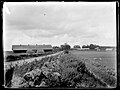 The Ettaks royal estate in 1930.
 -
 The church site and its surroundings to the west.
 -
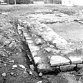 From the excavation of Ettak Church ruins by Nils Beerståhl, 1970.
 -
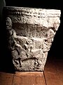
 Pillars found in Härja, likely part of larger portal probably comes from Ettak.
 -
 A ring discovered during the excavation, not made of iron.
 -
 A roof detail on the Baptistery.
 -
 A roof detail of horses coming to water.
 -
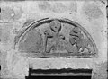
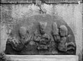
 The Romanesque tympanum at Härja parish church, believed to have belonged to the medieval royal estate of nearby Ettak.


Velinga Church[edit]
-
 The church exterior from the southwest.
 -
 The church from the northwest.
 -
 Tympanum exterior detail 1.
 -
 Tympanum exterior detail 2.
 -
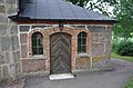 Exterior exit 1.
 -
 Exterior exit 2.


See also[edit]
External links[edit]
References[edit]
- ^ [ a b ] Sjögren, Otto (1933). Sweden, the geographical description, section 4, of the Gothenburg and Bohus county, Älvsborg, Skaraborg, and The county. Stockholm, Sweden: Wahlström & Widstrand. See: 9941
- ^ Carl-Olof Siljedahl. (2015) "Monuments in the Landscape: A spatial analysis of rune stones in Västergötland during the Late Viking Age and early Medieval period." Lund University, Sweden.
- ^ "Välkommen till Västsverige | Officiell besöksguide". www.vastsverige.com (in Swedish). Retrieved 2024-04-11.
- ^ "Kringla". Kringla (in Swedish). Retrieved 2024-04-11.
- ^ "Velinga kyrka". www.svenskakyrkan.se (in Swedish). 2023-05-10. Retrieved 2024-04-11.
- ^ a b Svensk Uppslagsbok andra upplagan 1947–1955: Velinga socken
- ^ "Ettaks strömmar". www.vastsverige.com. Retrieved 2024-04-11.
- ^ Riksarkivet. "Riksarkivet - Sök i arkiven". sok.riksarkivet.se (in Swedish). Retrieved 2024-01-12.
- ^ Harlén, Hans (2003). Sverige från A till Ö: geografisk-historisk uppslagsbok. Stockholm: Kommentus. ISBN 978-91-7345-139-0.
- ^ a b "Västra Götaland | Population, Cities, Culture | Britannica". www.britannica.com. Retrieved 2024-04-11.
- Populated places in Västra Götaland County
- Parishes of the Church of Sweden
- Viking Age in Sweden
- Medieval Sweden
- Runestones in Västergötland
- Norse history and culture articles
- History of Scandinavia
- Viking art
- Architecture in Sweden
- Burial monuments and structures in Sweden
- Bronze Age sites in Europe
- Iron Age sites in Europe
- Cairns (stone mounds)
- Medieval churches
- Churches completed in the 1100s
- Medieval architecture
- Romanesque architecture in Sweden
- Ruins in Sweden
- Middle Ages portal
- 12th-century establishments in Sweden