
Velvary
Velvary | |
|---|---|
 Krále Vladislava Square, the historic centre | |
 Flag  Coat of arms | |
 Velvary Location in the Czech Republic | |
| Coordinates: 50°16′54″N 14°14′10″E / 50.28167°N 14.23611°E | |
| Country | |
| Region | Central Bohemian |
| District | Kladno |
| First mentioned | 1282 |
| Government | |
| • Mayor | Radim Wolák |
| Area | |
| • Total | 18.10 km2 (6.99 sq mi) |
| Elevation | 188 m (617 ft) |
| Population (2023-01-01)[1] | |
| • Total | 2,986 |
| • Density | 160/km2 (430/sq mi) |
| Time zone | UTC+1 (CET) |
| • Summer (DST) | UTC+2 (CEST) |
| Postal code | 273 24 |
| Website | www |
Velvary (Czech pronunciation: [ˈvɛlvarɪ]) is a town in Kladno District in the Central Bohemian Region of the Czech Republic. It has about 3,000 inhabitants. The historic town centre is well preserved and is protected by law as an urban monument zone.
Administrative parts[edit]

The villages of Ješín, Malá Bučina and Velká Bučina are administrative parts of Velvary.
Etymology[edit]
The name is derived from velvaři, which was a colloquial term for people who cooked a lot (from velmi vařit, i.e. "to cook a lot").[2]
Geography[edit]
Velvary is located about 18 kilometres (11 mi) northeast of Kladno and 22 km (14 mi) northwest of Prague. It lies in a flat agricultural landscape of the Lower Ohře Table. The highest point is at 272 m (892 ft) above sea level. The stream of Bakovský potok flows through the town.
History[edit]
The first written mention of Velvary is from 1282. For centuries, it was an important stop on the way from Prague to Saxony. After 1357, it became a royal property and it was promoted to a market town by King Charles IV. In 1482, it was promoted to a town by King Vladislaus II.[3]
Demographics[edit]
|
|
| ||||||||||||||||||||||||||||||||||||||||||||||||||||||
| Source: Censuses[4][5] | ||||||||||||||||||||||||||||||||||||||||||||||||||||||||
Transport[edit]
The I/16 road (the section that connects Mělník with the D6 motorway) passes through the town.
Velvary is the terminus of a short local railway line heading from Kralupy nad Vltavou.[6]
Sport[edit]
The town is home to a football club TJ Slovan Velvary, which plays in the Bohemian Football League (third tier of the Czech football league system).
Sights[edit]

The major sights of the spacious Krále Vladislava Square include a Baroque Marian column (built in 1716–1719), a Baroque town hall from 1717, and the Gothic Church of Saint Catherine with murals from the 15th century. The Renaissance Prague Gate from 1580 is the last preserved of three town gates. There is also a valuable Renaissance Church of Saint George (built in 1613–1616) with a churchyard.[3]
Notable people[edit]
- Jan Antonín Koželuh (1738–1814), composer
- Leopold Koželuh (1747–1818), composer
- Václav Klement (1868–1938), automotive pioneer
- Karel Treybal (1885–1941), chess player; worked here
Gallery[edit]
-
 Renaissance house No. 57 on the town square
 -
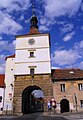 The Prague Gate
 -
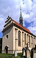 Church of Saint George


References[edit]
- ^ "Population of Municipalities – 1 January 2023". Czech Statistical Office. 2023-05-23.
- ^ Profous, Antonín (1957). Místní jména v Čechách IV: S–Ž (in Czech). pp. 498–499.
- ^ a b "Historie města" (in Czech). Město Velvary. Retrieved 2021-06-23.
- ^ "Historický lexikon obcí České republiky 1869–2011 – Okres Kladno" (in Czech). Czech Statistical Office. 2015-12-21. pp. 9–10.
- ^ "Population Census 2021: Population by sex". Public Database. Czech Statistical Office. 2021-03-27.
- ^ "Detail stanice Velvary" (in Czech). České dráhy. Retrieved 2023-11-21.
External links[edit]
| International | |
|---|---|
| National | |