
Vimy Peak
| Vimy Peak | |
|---|---|
 Vimy Peak | |
| Highest point | |
| Elevation | 2,385 m (7,825 ft)[1] |
| Prominence | 190 m (620 ft)[1] |
| Parent peak | Arras Peak (2423 m)[1] |
| Listing | Mountains of Alberta |
| Coordinates | 49°02′18″N 113°51′29″W / 49.03833°N 113.85806°W[2] |
| Geography | |
 Vimy Peak Location of Vimy Peak in Alberta  Vimy Peak Vimy Peak (Canada) | |
| Location | Alberta, Canada |
| Parent range | Canadian Rockies |
| Topo map | NTS 82H4 Waterton Lakes[2] |
| Geology | |
| Age of rock | Cambrian |
| Climbing | |
| Easiest route | Hiking trail[3] |
Vimy Peak is a 2,385-metre (7,825-foot) summit located in Waterton Lakes National Park, in the Canadian Rockies of Alberta, Canada. It is set along the east shore of Waterton Lake on the opposite side from Waterton Park townsite. It is situated 5.4 km (3.4 mi) west of Sofa Mountain, and the nearest higher neighbor is Arras Peak, 3.1 km (1.9 mi) to the southeast.[1] Vimy Peak anchors the northern end of Vimy Ridge, which stretches three kilometers to Arras Peak anchoring the southern end.
History[edit]
The mountain was originally labelled as Sheep Mountain on George Dawson's 1886 map.[1] Kootenay Brown referred to it as Goat Mountain.[4] However, in 1917 it was renamed in honor of the Canadian Army's victory at the Battle of Vimy Ridge, to commemorate all who survived and died in the World War I battle.[5] This mountain's name was officially adopted in 1943 by the Geographical Names Board of Canada.[2]
Geology[edit]
Like other mountains in Waterton Lakes National Park, Vimy Peak is composed of sedimentary rock laid down during the Precambrian to Jurassic periods. Formed in shallow seas, this sedimentary rock was pushed east and over the top of younger Cretaceous period rock during the Laramide orogeny.[6]
Climate[edit]
Based on the Köppen climate classification, Vimy Peak is located in a subarctic climate with cold, snowy winters, and mild summers.[7] Temperatures can drop below −20 °C with wind chill factors below −30 °C. Precipitation runoff from Vimy Peak drains into Waterton Lake, thence Waterton River.
Gallery[edit]
-
-
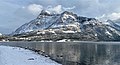
 Vimy Peak above Waterton Lake
 -
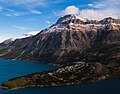
 Sofa Mountain, Vimy Peak, and Mt. Cleveland seen from Bellevue Peak


See also[edit]
References[edit]
- ^ a b c d e "Vimy Peak". Bivouac.com. Retrieved 2018-11-24.
- ^ a b c "Vimy Peak". Geographical Names Data Base. Natural Resources Canada. Retrieved 2018-11-24.
- ^ Vimy Peak SummitPost
- ^ "Vimy Peak". cdnrockiesdatabases.ca. Retrieved 2019-08-19.
- ^ Vimy Place-names of Alberta, page 129
- ^ Gadd, Ben (2008). "Geology of the Rocky Mountains and Columbias".
{{cite journal}}: Cite journal requires|journal=(help) - ^ Peel, M. C.; Finlayson, B. L.; McMahon, T. A. (2007). "Updated world map of the Köppen−Geiger climate classification". Hydrol. Earth Syst. Sci. 11 (5): 1633–1644. Bibcode:2007HESS...11.1633P. doi:10.5194/hess-11-1633-2007. ISSN 1027-5606. S2CID 9654551.
External links[edit]
- Parks Canada web site: Waterton Lakes National Park
- Vimy Peak weather: Mountain Forecast