
Warman, Minnesota
Warman | |
|---|---|
 Warman Location of the community of Warman within Peace Township, Kanabec County  Warman Warman (the United States) | |
| Coordinates: 46°03′30″N 93°17′04″W / 46.05833°N 93.28444°W | |
| Country | United States |
| State | Minnesota |
| County | Kanabec |
| Township | Peace Township |
| Elevation | 1,161 ft (354 m) |
| Time zone | UTC-6 (Central (CST)) |
| • Summer (DST) | UTC-5 (CDT) |
| ZIP code | 55051 |
| Area code | 320 |
| GNIS feature ID | 653781[1] |
Warman is an unincorporated community in Peace Township, Kanabec County, Minnesota, United States.
The community is located north of Mora, near the junction of State Highway 65 (MN 65) and Kanabec County Roads 24 and 25.
Warman is located 13 miles north of Mora; and 14 miles east-southeast of Isle.
Snowshoe Brook flows through the community. Warman is located within ZIP code 55051, based in Mora.
History[edit]
Warman, located in sections 5 and 6 of Peace Township, was named in honor of S. M. Warman, a granite quarry owner who was killed by the fall of a derrick. According to author and geologist Warren Upham, Warman opened a granite quarry in 1907, and on July 18 of that year, he and his wife, Sarah J. Warman, platted a community named Warman Creek on the west side of what now is State Highway 65, while N. C. Pike of Pike–Horning Granite Company, on July 23, 1907, platted a community on the east side of the roadway calling it East Mora.[2] Eventually, these two small, competing communities merged to form the unincorporated community of Warman. A post office operated from 1907 until 1920.[3]
References[edit]
- ^ "Warman, Minnesota". Geographic Names Information System. United States Geological Survey, United States Department of the Interior.
- ^ Upham, Warren. Minnesota Place Names: Their Origin and Historic Significance
- ^ "Kanabec County". Jim Forte Postal History. Retrieved July 15, 2015.
- Rand McNally Road Atlas – 2007 edition – Minnesota entry
- Official State of Minnesota Highway Map – 2013/2014 edition
Municipalities and communities of Kanabec County, Minnesota, United States | ||
|---|---|---|
| Cities | 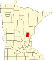 | |
| Townships | ||
| Unincorporated communities | ||
| Indian reservation | ||
| Footnotes | ‡This populated place also has portions in an adjacent county or counties | |