
Watson, Kansas
Watson, Kansas | |
|---|---|
 | |
 Watson  Watson | |
| Coordinates: 38°59′17″N 95°33′23″W / 38.98806°N 95.55639°W[1] | |
| Country | United States |
| State | Kansas |
| County | Shawnee |
| Township | Monmouth |
| Elevation | 1,083 ft (330 m) |
| Time zone | UTC-6 (CST) |
| • Summer (DST) | UTC-5 (CDT) |
| Area code | 785 |
| FIPS code | 20-76010 |
| GNIS ID | 479095 [1] |
Watson is an unincorporated community in Shawnee County, Kansas, United States.[1]
Demographics[edit]
Watson is part of the Topeka, Kansas Metropolitan Statistical Area.
Education[edit]
The community is served by Shawnee Heights USD 450 public school district, and two schools are located in Watson: Shawnee Heights High School and Shawnee Highs Middle School.
References[edit]
Further reading[edit]
External links[edit]
Municipalities and communities of Shawnee County, Kansas, United States | ||
|---|---|---|
| Cities | 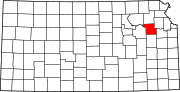 | |
| Unincorporated communities | ||
| Ghost towns | ||
| Townships | ||
| Footnotes | †This community is designated a Census-Designated Place (CDP) by the United States Census Bureau. ‡This community also has portions in an adjacent county or counties. | |