
Whorl Mountain (Yosemite)
| Whorl Mountain | |
|---|---|
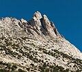
 North aspect, from Matterhorn Peak | |
| Highest point | |
| Elevation | 12,039 ft (3,669 m) NAVD 88[1] |
| Prominence | 673 ft (205 m)[1] |
| Coordinates | 38°04′27″N 119°23′00″W / 38.0741212°N 119.3834283°W[2] |
| Geography | |
 Whorl Mountain Whorl Mountain  Whorl Mountain Whorl Mountain (the United States) | |
| Location | |
| Parent range | Ritter Range |
| Topo map | USGS Matterhorn Peak |
| Climbing | |
| First ascent | July 9,1933 by Herbert Blanks, Kenneth May and Eliot Sawyer[3] |
| Easiest route | Exposed scramble, class 3.[3] |
Whorl Mountain is a mountain in the northern part of Yosemite National Park, well north of Mount Conness, and barely inside the boundary of Yosemite. Whorl Mountain is the 22nd-highest mountain in Yosemite National Park.[4]
Whorl Mountain is 1.3 miles (2.1 km) south of Matterhorn Peak.[5] Bath Mountain is 4.6 miles (7.4 km) west-south-west, and Excelsior Mountain is 5.5 miles (8.9 km) to the southeast.
On climbing Whorl Mountain[edit]
Whorl Mountain is a class 3 climb.[3]
Gallery[edit]
-

-
 Whorl Mountain summit
 -
 South aspect


.jpg)
References[edit]
- ^ a b "Whorl Mountain, California". Peakbagger.com. Retrieved 2019-03-13.
- ^ "Whorl Mountain". Geographic Names Information System. United States Geological Survey, United States Department of the Interior. Retrieved 2021-11-19.
- ^ a b c Secor, R. J. (1997). The High Sierra: Peaks, Passes and Trails (1st ed. revised). Seattle: The Mountaineers Books. ISBN 978-0898869712.
- ^ "Yosemite NP Peaks". Peakbagger.com. Retrieved 2021-11-19.
- ^ "Whorl Mountain". SummitPost.org. Retrieved 2021-11-19.