Whorlton, North Yorkshire
| Whorlton | |
|---|---|
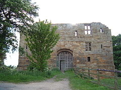
 Whorlton Castle gatehouse | |
Location within North Yorkshire | |
| Population | 597 (2011 census)[1] |
| OS grid reference | NZ484024 |
| Civil parish |
|
| Unitary authority | |
| Ceremonial county | |
| Region | |
| Country | England |
| Sovereign state | United Kingdom |
| Post town | NORTHALLERTON |
| Postcode district | DL6 |
| Police | North Yorkshire |
| Fire | North Yorkshire |
| Ambulance | Yorkshire |
Whorlton is a hamlet and civil parish in the Hambleton District of North Yorkshire, England. It is very near Swainby and the A19, and 6 miles south west of Stokesley. Features include the remains of Whorlton Castle and the Church of the Holy Rood.[2][3]
Whorlton Castle was built by Robert de Meynell as a typical 12th century motte and bailey Norman castle. A gatehouse was added in the 14th century. The only remains visible today are the grade I listed gatehouse and traces of the grade II* listed undercrofts (or cellars) of the main building. Due to vandalism access to the site is restricted.[4][5][2]
References[edit]
- ^ UK Census (2011). "Local Area Report – Whorlton Parish (1170216959)". Nomis. Office for National Statistics. Retrieved 23 July 2018.
- ^ a b Wilson, Martin P. (27 June 2011). "Whorlton, Old Church, Castle and Abandoned Village". The Winding Way. Retrieved 11 December 2013.
- ^ Archbishops' Council (2010). "Holy Cross Old Church, Whorlton, Swainby". Diocese of York. Retrieved 15 August 2011.
- ^ Historic England. "WHORLTON CASTLE GATEHOUSE (1151332)". National Heritage List for England. Retrieved 11 December 2013.
- ^ Historic England. "RUINS OF WHORLTON CASTLE UNDERCROFTS (1189310)". National Heritage List for England. Retrieved 11 December 2013.
External links[edit]
![]() Media related to Whorlton, North Yorkshire at Wikimedia Commons
Media related to Whorlton, North Yorkshire at Wikimedia Commons

