
Whyburn
| Whyburn | |
|---|---|
 Whyburn by Spring Street | |
| Location | |
| Country | England |
| County | Nottinghamshire |
| Town | Hucknall |
| Physical characteristics | |
| Source | |
| • location | Hucknall |
| Mouth | River Leen |
• location | Bestwood Village |
• coordinates | 53°1′47″N 1°10′56″W / 53.02972°N 1.18222°W |
| Length | 5.01 km (3.11 mi) |
| Basin size | 8.25 km2 (3.19 sq mi)[1] |
The Whyburn (known locally as Town Brook, and by the UK Government as Baker Lane Brook) is the main watercourse flowing through the town of Hucknall in the English county of Nottinghamshire. It rises in two separate springs at the foot of the Misk Hills by Whyburn Farm, and flows east into the town of Hucknall, past Whyburn Lane to which it also gives its name. The brook once drove several mills in Hucknall, the most notable example being close to the junction of Baker Street and Annesley Road near the town centre.[2] In the History of Hucknall Torkard it is suggested that a mill pond once existed close to the former village green (now the Market Place).[2]
The name of the stream is thought to be derived from a Celtic word 'Wy' meaning 'water'.[3] The Whyburn has a total length of around 5.01 kilometres (3.11 mi), and terminates in a confluence with the River Leen immediately upstream of Bestwood Village Mill Lakes. A school used to take the name of 'Whyburn'.[4]
Whyburn | |||||||||||||||||||||||||||||||||||||||||||||||||||||||||||||||||||||||||||||||||||||||||||||||||||||||||||||||||||||||||||||||||||||||||||||||||||||||||||||||||||||||||||||||||||||||||||||||||||||||||||
|---|---|---|---|---|---|---|---|---|---|---|---|---|---|---|---|---|---|---|---|---|---|---|---|---|---|---|---|---|---|---|---|---|---|---|---|---|---|---|---|---|---|---|---|---|---|---|---|---|---|---|---|---|---|---|---|---|---|---|---|---|---|---|---|---|---|---|---|---|---|---|---|---|---|---|---|---|---|---|---|---|---|---|---|---|---|---|---|---|---|---|---|---|---|---|---|---|---|---|---|---|---|---|---|---|---|---|---|---|---|---|---|---|---|---|---|---|---|---|---|---|---|---|---|---|---|---|---|---|---|---|---|---|---|---|---|---|---|---|---|---|---|---|---|---|---|---|---|---|---|---|---|---|---|---|---|---|---|---|---|---|---|---|---|---|---|---|---|---|---|---|---|---|---|---|---|---|---|---|---|---|---|---|---|---|---|---|---|---|---|---|---|---|---|---|---|---|---|---|---|---|---|---|---|
| |||||||||||||||||||||||||||||||||||||||||||||||||||||||||||||||||||||||||||||||||||||||||||||||||||||||||||||||||||||||||||||||||||||||||||||||||||||||||||||||||||||||||||||||||||||||||||||||||||||||||||
Flood mitigation measures[edit]
The path of the Whyburn takes it though urban built up areas of Hucknall. In order to reduce the risk of urban flooding, several flood mitigation measures have been implemented along its length, including retention ponds, flood barriers, a monitoring station, and flood warning services.
In spite of the measures, the brook has flooded several times. The highest recorded river level was measured at 1.47 metres (4 ft 10 in) during Storm Babet in October 2023.[5]
-
 Disused mill by Bakers Street
 -
 River monitoring station on Spring Street
 -
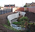 Curved feature beside Torkard Way
 -
 Passing by Wigwam Lane business park


See also[edit]
References[edit]
- ^ "Baker Lane Brook Catchment (trib of Leen) Water Body". Department for Environment Food & Rural Affairs. Retrieved 29 October 2023.
- ^ a b Beardsmore (1909). "Broxtowe Wapentake". Retrieved 29 October 2023.
- ^ Beardsmore (1909). "Place Names". Retrieved 29 October 2023.
- ^ "Education League Tables: Whyburn Primary School". BBC. 2 December 2005. Retrieved 29 October 2023.
- ^ John Smith (20 October 2023). "25 pictures of dramatic Hucknall and Bulwell flooding as Storm Babet strikes". Hucknall Dispatch. Retrieved 29 October 2023.
Bibliography[edit]
- Beardsmore, J. H. (1909), History of Hucknall Torkard
- "Strategic Flood Risk Assessment Level 1" (PDF). Ashfield District Council. February 2009. Retrieved 23 October 2023.
- "Schemes for Discharge of Conditions". Nottinghamshire County Council. 2 January 2013. Retrieved 29 October 2023.
- "Autumn rains bring further flood fear for residents". Hucknall Dispatch. 26 October 2013. Retrieved 23 October 2023.
- "Flood grant application by county council to help flood risk Hucknall". Hucknall Dispatch. 28 March 2014. Retrieved 23 October 2023.
- "Hucknall Town Centre Flood Alleviation Project" (PDF). Nottinghamshire County Council. 14 July 2017. Retrieved 23 October 2023.
- "Flooding at Thoresby Dale in Hucknall". Nottinghamshire County Council. 2020. Retrieved 23 October 2023.
- "Environment Agency launches new Flood Warning Services". UK Environment Agency. 1 March 2023. Retrieved 29 October 2023.
External links[edit]
- Baker Lane Brook level at Hucknall Gov.UK - Check for flooding
- Baker Lane Brook at Hucknall - River Levels
- Top of the Poops
| Rivers | |
|---|---|