
Wikipedia:Graphics Lab/Map workshop/Archive/Dec 2021
| This page is an archive. Do not edit the contents of this page. Please direct any additional comments to the current main page. |

Bucharest Botanical Garden area map
- Article(s)
- Bucharest Botanical Garden
- Request
- I'd like to request an area map of the garden, such as the official one. I believe an overlay over the OSM map (the garden is the big green area) should be enough. Ideally, any labels should be translatable using svgtranslate. Thanks! -- Strainu (talk) 00:11, 2 December 2021 (UTC)
- Discussion
Request Treaty of London (1915) map
-
 This image contains a fairly accurate depiction of the promised border in Dalmatia, Istria and the Slovene Lands, albeit with few minor discrepancies with written sources (Snežnik Plateau, Krka River tributaries - see here)
 -
 This image contains an accurate depcition of the promised division of Tyrol
 -


- Article(s)
- Treaty of London (1915), likely in several other linked articles Mutilated victory etc.
- Request
- Would it be possible to create a vector map of territories promised to Italy under the 1915 Treaty of London. Currently there is an unsatisfactory solution available (only a part of the area shown - Dalmatia/Istria or Tyrol, not both). Since all these areas are not shown in relation to each other and the rest of Italy, currently available maps (used in the article now) are of limited value. A reliable source for the map is available here at page 32. A blank location map allowing use of pins would be quite satisfactory IMO. Thank you! -- Tomobe03 (talk) 23:54, 16 August 2021 (UTC)
- Just to note, the southern boundary (running NE from Cape Planka) is not precisely defined except that it leaves all tributaries of Krka in the territory ceded to Italy. It occurred to me that it would probably be helpful to point out that the present-day boundary of the Šibenik-Knin County and the Split-Dalmatia County is not far from the watershed line (within 2km E from Cape Planka and similarly not far from sources of Čikola, Cetina etc.). While it is not exact representation of the line determined by the Treaty of London, it would be quite close to accurate on the map of scale showing both Dalmatia and Trentino.
- The Snežnik plateau issue is that the treaty says that the boundary goes to the plateau and from the plateau without specifying who controls the plateau or if it is divided (and how). That is the lighter shaded area in the map here and the matter was addressed in 1920 by a separate treaty.--Tomobe03 (talk) 07:44, 23 August 2021 (UTC)
- Discussion
Just put up a draft - let me know what you think/what I should add/improve. The accuracy isn't as good as I'd like but that's mainly because I couldn't find a more precise open source basemap of world borders around the relevant time. Jcw12 (talk) 10:22, 27 September 2021 (UTC)
- Hey, thanks for taking this up. The map looks nice, but there are couple of issues which could be improved: Specifically, the Italian northeast border (i.e. the area shaded blue) is incorrect as it appears to coincide post WWII borders instead of pre-1914 borders. There is an SVG outline map of those here File:Kingdom of Italy 1870.svg and a bitmap here File:Italy_unification_1815_1870.jpg. The second place for improvement could be the Adriatic coastline and islands, especially since they are mentioned in considerable detail by relevant treaty. There is an SVG map of the coastline and the islands available here File:Adriatic_Sea_Currents_2.svg. I would also suggest you to use another colour for the "unclear" territory and remove the key (and the title on top) from the map. This would allow use of the map on non-English wikis with key added to image caption. Your work so far looks quite impressive!--Tomobe03 (talk) 21:52, 3 October 2021 (UTC)
- Thanks for the input, I'll get to work on fixing it. Unfortunately I'm in the middle of finals at university so It'll be a little while before I can update it. I'll try get onto it as soon as I have some spare time - might take around a week or so. Thanks again, Jcw12 (talk) 13:34, 8 October 2021 (UTC)
- Just uploaded a version with the changes you mentioned. Different projections made it a bit difficult but I fixed the things you mentioned, also increased the scale a little bit to make the islands clearer. - let me know if I missed anything or you'd like any other changes. Thanks Jcw12 (talk) 14:04, 18 October 2021 (UTC)
- Jcw12 thanks, it looks great!--Tomobe03 (talk) 10:59, 6 November 2021 (UTC)
- However, there's one other cartographical error - the Bay of Kotor was a part of Austria-Hugary in 1915 (at the time of conclusion of the Treaty). Could you please fix that? There is an outline map in the Bay of Kotor infobox, where the green-shaded arrea generally corresponds to the relevant area (at least at this scale there is no major difference). Technically, the map could be cropped at the bottom a bit to leave the bay out of the map and fix it that way too.--Tomobe03 (talk) 11:31, 6 November 2021 (UTC)
- Just uploaded a version with the changes you mentioned. Different projections made it a bit difficult but I fixed the things you mentioned, also increased the scale a little bit to make the islands clearer. - let me know if I missed anything or you'd like any other changes. Thanks Jcw12 (talk) 14:04, 18 October 2021 (UTC)
- Thanks for the input, I'll get to work on fixing it. Unfortunately I'm in the middle of finals at university so It'll be a little while before I can update it. I'll try get onto it as soon as I have some spare time - might take around a week or so. Thanks again, Jcw12 (talk) 13:34, 8 October 2021 (UTC)
Update Map of Parties to the Underwater Cultural Heritage Convention
-
 Map of states that have ratified the UNESCO 2001 Convention on the Protection of the Underwater Cultural Heritage, as of 23-02-2015

- Article(s)
- UNESCO Convention on the Protection of the Underwater Cultural Heritage
- Request
- This map was last updated in February 2015, but the convention has since then been ratified by 22 additional countries. See the bottom of this page for a list of the current states parties. Swaggernagger (talk) 14:59, 6 December 2021 (UTC)
Request for a map of the Willapa Hills Trail in Washington state
-
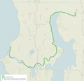 Burke-Gilman Trail map!

- Article(s)
- Willapa Hills Trail
- Request
- Trail map for the Willapa Hills Trail? Please?!
- Really like the map at the Burke–Gilman Trail article and hoping for something similar if not exact. Doesn't need to be fancy or point out any landmarks. I did some due diligence at WikiCommons and other sites but nothing that works or it scares the pinky toe off me due to copyright stuff. Since I cannot even figure out how to rotate an uploaded photo at the Commons, I highly doubt anyone here would want me to build a map. I would imagine the world would end, at the least.
- A trail map about the Willapa can be found here
- Thanks so very much in advance! If I've overstepped or you need more info...shout at me and I'll correct it.
-- Shortiefourten (talk) 03:01, 12 December 2021 (UTC)
- Discussion
@Shortiefourten: Glad to help with a trail map. Working a few projects, so I would need some time before I get started on it. If you haven't found a solution yet, please let me know. - DutchTreat (talk) 16:31, 16 December 2021 (UTC)
Arab League member states map
{{resolved}}
-
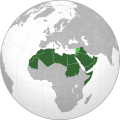 An edited version of this map
.svg)
- Article
- Arab League
- Request
- File:Arab League member states (orthographic projection).svg, until recently used in the infobox of the Arab League article, for some reason shows the Western Sahara as an integral part of Morocco, but it shouldn't (see Talk:Arab League/Archive 1#Infobox map: Western Sahara). I would like to request a version of this map which shows the Western Sahara as a separate, grey (non–member) territory. File:Arab_League_(orthographic_projection)_updated.svg, which I've used as a temporary replacement, is correct but inferior in other aspects. Lennart97 (talk) 16:00, 26 December 2021 (UTC)
- Discussion
- Hello, seems like this decision was made because the Arab League recognizes the Moroccan claim over Western Sahara and has since 1999. MakhzenHuman (talk) 19:16, 11 January 2022 (UTC)
...anyone? This should be relatively easy right? Lennart97 (talk) 21:02, 25 January 2022 (UTC)
- @Lennart97: Please have a look at File:Member states of the Arab League (orthographic projection).svg and let me know if I missed something. The map has been edited by hand to make it very easy to change (should Syria rejoin the league). Have a look at the source to know what I mean. M.Bitton (talk) 21:50, 25 January 2022 (UTC)
Request map of Ireland's Eircode (postal code) routing areas
{{resolved}}
-
 This is an existing map of Ireland's county boundaries
 -
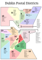 And an existing map of Dublin's historic, now technically defunct, postal districts


- Article(s)
- List of Eircode routing areas in Ireland and likely in Postal addresses in the Republic of Ireland
- Request
- Hi there! Anyone interested in putting together a map of Ireland's Eircode routing key areas? These are the rough equivalent to the UK's postal towns. Here is an external site with them mapped already and an interactive Google Map of them, too. -- BaronNethercross (talk) 16:20, 15 January 2022 (UTC)
- Discussion
- A problem with this is that the Eircode data, unlike UK postcode data which the ONS and OS have released under a free license, is only available on a paid license. Understandably, this isn't very popular with data users. — Berrely • Talk∕Contribs 20:16, 25 January 2022 (UTC)
- @Berrely: Eircodes and Eircode Routing Keys are two different things.
- @BaronNethercross: Please have a look at File:Eircode Routing Keys.svg and let me know if I missed something. M.Bitton (talk) 21:50, 25 January 2022 (UTC)
- @Berrely: Hi, thanks for responding! Yeah, I am suggesting a map of the Eircode routing key areas, which are publicly available. A map of Eircodes in full (routing key area + individual address identifier) would be near-impossible because it would be a map of every single individual address in the Republic, and as you say, there is a limit on how many one can look up! The limit exists precisely because a "full" Eircode is so specific.
- Routing keys ares, as shown shown here, are very like postcode areas in the UK.. K67 is one for example, as is D6W. You have to zoom in on the map a little to see them. They are identifiable geographic areas. The UK article has a map of the UK with its postcode areas and I was hoping for similar one for Ireland. I also created the Wikipedia list of routing keys areas in Ireland.
- @BaronNethercross: Did you have a look at the map? M.Bitton (talk) 22:16, 25 January 2022 (UTC)
- @Berrely: Yeah, I looked at the map. It shows the geographic areas the codes cover and has the three digit codes near the centre of each. Are we talking about the same map?!
- Routing keys ares, as shown shown here, are very like postcode areas in the UK.. K67 is one for example, as is D6W. You have to zoom in on the map a little to see them. They are identifiable geographic areas. The UK article has a map of the UK with its postcode areas and I was hoping for similar one for Ireland. I also created the Wikipedia list of routing keys areas in Ireland.
- @BaronNethercross: I am not "Berrely" and I was reffering to the map that I uploaded. M.Bitton (talk) 22:25, 25 January 2022 (UTC)
- @M.Bitton: My apologies! It must be the long day I had. Your map is great! Thank you. So good. I think adding the keys to it might be a tedious and guess we can use it as is.
- @BaronNethercross: Adding the 139 keys to it is both tedious and impractical (some areas are extremely small), but since the map has been optimized by hand, showing any key area can easily be achieved by adding a single line to the file. M.Bitton (talk) 22:39, 25 January 2022 (UTC)
- @M.Bitton: Yes, totally agree. That's great. Thank you!
- @BaronNethercross: You're welcome. One last thing: in accordance with the map that you linked to, the areas that fall within the Shannon Estuary have been assigned their own classes (-SE suffix). Have a look at the source of the file and if any of it is unclear, let me know. Best, M.Bitton (talk) 22:48, 25 January 2022 (UTC)
Topographical location map for Fiordland
-
 Current topo map of Fiordland

- Article(s)
- Used as a location map for features within the subject area, such as Milford Sound / Piopiotahi or Taiari / Chalky Inlet
- Request
- I previously made the above map to use as a location map for articles about geographic features within the subject area of Fiordland, New Zealand, but obviously the above map has a few issues. The main one I faced was that I couldn't find a suitably detailed bathymetric data set with the right settings and CC license (I was originally using NIWA bathymetric data but this was a topographic vector and doesn't appear to be free use). I originally used local data from Land Information New Zealand for this map as it was far more detailed than other international sources and has the right creative commons licences (specifically this set), as well as separate ones for lake, coastline, and river layers. -- Turnagra (talk) 20:44, 6 February 2022 (UTC)
{{resolved}}
- Discussion
Hi @Turnagra. Cloud you please specify what exactly is requested? You mention "a few issues" but the only one described is the lack of bathymetry. Would you like to have the same map with bathymetry? Thanks --Ikonact (talk) 08:17, 7 February 2022 (UTC)
- Thanks Ikonact, sorry I wasn't clearer. Ideally I'd like that map in a consistent format to other topographical / relief location maps. If the bathymetry is the only issue then that's awesome, but I'm not sure if the rest of it is right (for instance, the data set I was using for the rivers seems to have resulted in some weird dotted lines instead of proper rivers, and I'm not sure if I did the shading right) so I figured I'd let someone with a bit more cartographical experience be the judge! Turnagra (talk) 08:58, 7 February 2022 (UTC)
- @Turnagra I made a draft here. I see there is some mismatch between coast and relief. I will work on this. Let me know if OK or not. Thanks --Ikonact (talk) 16:42, 7 February 2022 (UTC)
- @Ikonact That looks great, thank you! Much nicer projection than mine as well. Is it worth having the little location inset still, to show where Fiordland is in relation to New Zealand? Turnagra (talk) 18:07, 7 February 2022 (UTC)
- @Turnagra I managed to improve the coastline. I would not put here the location map as it is jpg and my map is svg. What you can do is to save my map in png or jpg and add the location map. By the way, I have my script ready now for New Zealand so if you need other maps I can help. --Ikonact (talk) 20:25, 7 February 2022 (UTC)
- @Ikonact That looks great, thank you! Much nicer projection than mine as well. Is it worth having the little location inset still, to show where Fiordland is in relation to New Zealand? Turnagra (talk) 18:07, 7 February 2022 (UTC)
- @Turnagra I made a draft here. I see there is some mismatch between coast and relief. I will work on this. Let me know if OK or not. Thanks --Ikonact (talk) 16:42, 7 February 2022 (UTC)
Map of India
-
 Done
Done

- Article(s)
- Love Jihad
- Request
- Hi am just wondering can sombody make a india map of laws on Love Jihad. These states ban love Jihad Uttar Pradesh, Madhya Pradesh and Gujarat, they could be in red colour.
Thanks. La lopi (talk) 12:46, 13 December 2021 (UTC)
- Discussion
1. Gujarat, [1][2] 2. Madhya Pradesh, [3][4][5][6][7][8] 3. Uttar Pradesh, [9]
References
- ^ Langa, Mahesh (2021-04-01). "Gujarat Assembly passes 'love jihad' law". The Hindu. ISSN 0971-751X. Archived from the original on 6 June 2021. Retrieved 2021-06-06.
- ^ "Gujarat passes Bill to stop 'love jihad'". The Indian Express. 2021-04-02. Archived from the original on 6 June 2021. Retrieved 2021-06-06.
- ^ Siddique, Iram (27 December 2020). "MP 'love jihad' Bill tougher, but limits who can file FIR". The Indian Express. Archived from the original on 27 January 2021. Retrieved 13 February 2021.
- ^ "MP approves 'love Jihad' law; up to 10 years of jail, Rs 1 lakh fine for forced conversion". Press Trust of India. 27 December 2020. Archived from the original on 29 December 2020. Retrieved 13 February 2021 – via Business Today.
- ^ "India's Madhya Pradesh state now plans 'love jihad' law". Al Jazeera. Archived from the original on 28 December 2020. Retrieved 29 December 2020.
- ^ "Madhya Pradesh to take ordinance route to enforce anti-conversion law". Deccan Herald. 28 December 2020. Archived from the original on 24 June 2021. Retrieved 29 December 2020.
- ^ "'Love jihad': Madhya Pradesh Cabinet approves anti-conversion bill". Scroll.in. Archived from the original on 30 December 2020. Retrieved 29 December 2020.
- ^ "Madhya Pradesh to enforce 'love jihad' ordinance". Hindustan Times. 27 December 2020. Archived from the original on 28 December 2020. Retrieved 29 December 2020.
- ^ Lalchandani, Neha (25 November 2020). "Religious conversions bill: UP cabinet passes ordinance to check 'unlawful' religious conversions". The Times of India. Retrieved 2020-11-25.
- Discussion
- La lopi,
 Done File:Indian states that ban forced conversions map.svg — Berrely • Talk∕Contribs 17:12, 29 January 2022 (UTC)
Thanks for doing this. User talk:Berrely. La lopi (talk) 04:23, 1 February 2022 (UTC)
- {{resolved}} -- Guerillero Parlez Moi 13:29, 11 February 2022 (UTC)
Dutch Brazil
-
 Finished map

- Article(s)
- Dutch Brazil
- Request
- Original is non-free (c:Commons:Deletion requests/Files by H. Hettema Jr.), so the replacement will need to be self-drawn. -- Magog the Ogre (t • c) 14:55, 1 January 2022 (UTC)
- Discussion
- @Magog the Ogre would you prefer it on a relief map or a standard location map? — Berrely • Talk∕Contribs 18:16, 12 January 2022 (UTC)
- @Magog the Ogre Done File:Dutch Brazil 1630-1654 map.svg — Berrely • Talk∕Contribs 20:00, 12 January 2022 (UTC)
- {{resolved}} -- Guerillero Parlez Moi 13:29, 11 February 2022 (UTC)
- @Magog the Ogre
I am suggesting that a new field be added to template for PLSS used on all Townships
I think that all Townships within Wikipedia should have their Public Land Survey System shown in the infobox. For Hollywood township this would be shown as: Township 117 North, Range 26 West, Fifth Principal Meridian of the Public Land Survey System. I have placed it under geography for the townships of Carver county but I believe it should be placed in the infobox to the right by underneath Coordinates or a new box on its own. Any thoughts? — Preceding unsigned comment added by BradMoe (talk • contribs) 21:20, 20 January 2022 (UTC)
- {{resolved}} This is not the place to request infobox coding changes. -- Guerillero Parlez Moi 13:28, 11 February 2022 (UTC)
Metropolis of Bessarabia
-
 The map of the Metropolis of Bessarabia (with an incorrect Romanian flag)
 -
 The flag of Romania (with its stripes in the correct order)


- Article(s)
- Metropolis of Bessarabia
- Request
- Hi. I'm wondering can somebody please correct the Romanian flag on this map of the Metropolis of Bessarabia. The blue stripe is meant to be on the left and the red stripe is meant to be on the right (the yellow stays in the middle). The flag can also be changed into its official colours (shown beside the map on the right) if this makes the map look better. You should also give the Ukrainian flag displayed on the map its official colours (found at File:Flag of Ukraine (pantone colors).svg) if you add the official colours to the Romanian flag, though the Ukrainian flag displayed there is basically correct with it's colours already in the correct order so it isn't as necessary as the Romanian one but would be appreciated regardless. The error regarding the Romanian flag has existed on the file since 2008 since the file was originally uploaded to en wiki in 2007, changed to include the incorrect flag in 2008, then copied to Commons in 2012. Since this mistake was there for nearly 14 years, it's very important that it's corrected as soon as possible. Thanks in advance. --51.37.113.57 (talk) 23:08, 31 January 2022 (UTC)
- Discussion
![]() Done M.Bitton (talk) 00:33, 1 February 2022 (UTC)
Done M.Bitton (talk) 00:33, 1 February 2022 (UTC)
- Hello again. Thanks for the quick improvement, it's absolutely perfect! It looks even better than I thought it would look, and done faster too! As it is, the file is already great but it if M.Bitton would like to improve on it further, by all means please do so. Anyone else who wants to help out can help out too. Once again, Thanks! --109.78.173.247 (talk) 01:05, 1 February 2022 (UTC)
Hi once again M.Bitton. Look, the file is fine the way it is, that was just something I typed in case you wanted to do something extra with it. If you do want to add something, you could add the map of Romania and Ukraine bordering Moldova as in real life but this is unnecessary because you did everything I wanted done with the map. I've very grateful the work you did with it and you should consider the request done. Thanks yet again! --109.78.173.247 (talk) 14:18, 1 February 2022 (UTC)
- {{resolved}} -- Guerillero Parlez Moi 13:26, 11 February 2022 (UTC)
Request to modify geometric object (WIWOSM)


- Article(s)
- Omacha District
- Omacha District
- Request
- I would like you to correct the error made in the creation of the map (WIWOSM) for the District of Omacha -- VanishedUser 736253 (talk) 01:13, 1 February 2022 (UTC)
- Discussion
- Hi @VanishedUser 736253 I'm slightly confused. Do you want a new map to be created? What is the error you want to rectify? N.B. I moved the file to a more specific name. — Berrely • Talk∕Contribs 16:27, 4 February 2022 (UTC)
- {{resolved}} -- Guerillero Parlez Moi 13:25, 11 February 2022 (UTC)
Request Hesse relief
-
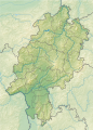 Hesse relief

_updated.svg)
.svg)
- Article(s)
- Request
- Please add the relief map of Hesse as image1 to Module:Location map/data/Germany Hesse. Thanks. Grimes2 (talk) 17:13, 10 February 2022 (UTC)
- Discussion
- @Grimes2 Done, as you are extended-confirmed, you are also able to do this yourself if you want. — Berrely • Talk∕Contribs 19:37, 10 February 2022 (UTC)
- Sorry, but it's commented out. Grimes2 (talk) 20:00, 10 February 2022 (UTC)
- Done Grimes2 (talk) 20:02, 10 February 2022 (UTC)
{{resolved}}.