
Wikipedia:Graphics Lab/Map workshop/Archive/Feb 2010
Stale[edit]
Aztec Empire[edit]

Article(s): Aztec
Request: Please Vectorize. Connormah (talk) 05:03, 7 December 2009 (UTC)
Graphist opinion(s): Whoever takes the request, please don't vectorize the modern states which did not exist at the time of the Aztecs. bamse (talk) 15:08, 7 December 2009 (UTC)
Indian state blank svgs needed[edit]
Hi. I noticed File:Assam protected areas map-blank.svg. We are desperately needing good svg blank maps of the states of India (with the districts lightly outlined) for use in pushpin in infoboxes. Basically I'm looking for a full set of maps of each of the Indian states in the style of File:Pakistan location map.svg. Like your Assam map but blank. Amazingly nobody has created blank svgs for India yet and we've had to put up with the horrible colored maps for ages. Could the graphics lab please create some good quality blank svgs and list the coordinates like on the Pakistan image page to make it possible to use for pin maps? Thanks. Dr. Blofeld White cat 19:59, 8 December 2009 (UTC)
- You should probably check in over at Wikipedia:WikiProject Indian maps to see if they're going to have heartburn over changing those. Many of those colored maps started out as blank ones and it would just be a matter of rolling them back to the earlier version, but I wouldn't do so without getting some consensus from the Indian maps folks. Kmusser (talk) 20:31, 8 December 2009 (UTC)
-
 Orthographic projection of Canada
.svg)
Article(s): Quebec, n:Portal:Quebec, ...
Request: Can you create the orthographic projection of Quebec plz ? It will be for the articles Quebec, Québec and for some portal on WP and Wikinews. Sniff (talk) 11:52, 11 December 2009 (UTC)
Graphist opinion(s): The map you give as an example comes from a range of maps showing countries and larger regions, including continents; for those, a position with respect to the world makes sense. For Quebec, currently all maps show the region in relation to Canada. An orthographic projection can of course be made, but I just want to make sure beforehand that this is not requested for secessionist purposes. By the way, you might also consider asking at commons:Grey-green orthographic projections maps. Classical geographer (talk) 13:33, 11 December 2009 (UTC)
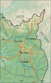
This article could be improved considerably with a map. LIST is going to be the best source for topography and the names of things. This gives a good overview. Walking tracks should be included - you can't drive most places there. Noodle snacks (talk) 04:35, 13 December 2009 (UTC)
Korean provinces/cities[edit]
-
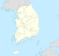 South Korea
 -
 North Korea
 -
 Korea
Korea


Additional maps:
- South Korea: commons:Category:Locator maps of provinces of South Korea, commons:Maps of South Korean divisions
- North Korea: commons:Category:Locator maps of provinces of North Korea, commons:Category:Provinces of North Korea, commons:Atlas of North Korea
Articles: South Korea: Busan, Chungbuk, Chungnam, Daegu, Daejeon, Gangwon, Gwangju, Gyeonggi, Gyeongbuk, Gyeongnam, Incheon, Jeju, Jeonbuk, Jeonnam, Seoul, Ulsan. North Korea: Chagang, Hambuk, Hamnam, Hwangbuk, Hwangnam, Kangwon, Kaesong, Kumgangsan, Pyongbuk, Pyongnam, Pyongyang, Rason, Ryanggang, Sinuiju.
Request: Can someone please make SVG locator maps for each province/city based visually on the maps above? I would appreciated it if someone could make two versions for each province/city: one within South/North Korea and one within the whole peninsula. The files should be named in a consistent manner. Article editor (talk) 00:52, 15 December 2009 (UTC)
Graphist opinion: Is something wrong with the older locator maps, such as this one:

Of course, the old map is not an SVG, but locating is just a dot placed over any map - whether it is SVG or JPG doesn't really matter, does it? Classical geographer (talk) 15:42, 17 December 2009 (UTC)
Cork Suburban Rail[edit]
Article(s): Cork Suburban Rail
Request: update map... Teddy455 (talk) 14:19, 24 November 2009 (UTC)
Graphist opinion(s): Those route maps are created by a template, they aren't a map in the sense that we work with here. You need to edit Template:Mallow to Youghal/Cobh. Kmusser (talk) 15:00, 24 November 2009 (UTC)
- Do you still want help with this request? If so, please can you tell us what exactly needs changing in the diagram? Certes (talk) 21:52, 23 December 2009 (UTC)
Mesoscale Discussion Graphic[edit]
Note: This request was moved from the Illustration workshop to the Map workshop.
-
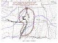 A mesoscale discussion graphic.

Article(s): Severe weather & Storm Prediction Center
Request: Not quite sure if this counts as a map or illustration, but either way, please vectorize. Ks0stm (T•C•G) 20:47, 27 December 2009 (UTC)
- Note: I moved this from the illustration workshop after being told it belonged here. Ks0stm (T•C•G) 00:11, 28 December 2009 (UTC)
Graphist opinion(s):
- It's an illustration of a map, so it belongs at the map workshop. ZooFari 23:40, 27 December 2009 (UTC)
- I'll move this request there then...thanks. Ks0stm (T•C•G) 00:05, 28 December 2009 (UTC)
- Can you explain why you'd want a vector version of this? If I look at its use at Storm_Prediction_Center?uselang=en#Mesoscale_discussions, it's presented as an actual graph produced by a forecasting center, and discussed as a historical example. Therefore the map is more like a photograph than an actual map, imho. Classical geographer (talk) 21:42, 28 December 2009 (UTC)
- I'll move this request there then...thanks. Ks0stm (T•C•G) 00:05, 28 December 2009 (UTC)
Resolved[edit]
Haiti earthquake[edit]


Article(s): Haiti earthquake
Request: English version please... Chris (クリス • フィッチュ) (talk) 11:12, 25 January 2010 (UTC)
Graphist opinion(s): ![]() Done Kmusser (talk) 14:46, 27 January 2010 (UTC)
Done Kmusser (talk) 14:46, 27 January 2010 (UTC)
- Fantastic, thank you! Um, since the map is in English, and attribution in the details, shouldn't the new name be in English? --Chris (クリス • フィッチュ) (talk) 12:49, 28 January 2010 (UTC)
Nueva Esparta[edit]
-
 Original Spanish map
 -
 MapMaster's update


Article(s): Nueva Esparta
Request: I have translated this map using (Template:Translation possible). But I really need help with changing MAR CARIBE to CARIBBEAN SEA. The letters are made of nodes, and not text. Thanks in advance. The Illusional Ministry (talk) 23:44, 25 November 2009 (UTC)
- I tried, and i looked good in inkscape, but when i uploaded it a get a big blue block where the text is supposed to be. The Illusional Ministry (talk) 12:54, 28 November 2009 (UTC)
Graphist opinion(s): Remove them and put in new text. It's Times New Roman, all-caps, bold italic. You can leave the original text in while you put in new text to get an idea of the 'right' size. (But of course, any size goes, as long as it's readable yet subtle.) Classical geographer (talk) 09:08, 26 November 2009 (UTC)
- Did you get this fixed? Do you still need help?? MapMaster (talk) 03:22, 18 January 2010 (UTC)
- Still need help. P. S. Burton (talk) 21:36, 25 January 2010 (UTC) (new username).
I just uploaded a new version. I not only fixed the big blue text block, I also enlarged the Legend, inserted a new locator map of Venezuela, set the ocean color to the English Wikipedia standard, changed the dashed border to a line, and enlarged the names of the islands. I also pulled the title of the map and the little teeney coordinate numbers inside the map, where they belong. All of these edits, in my opinion at least, make the map a bit easier to read and understand. Hope you like them. MapMaster (talk) 15:01, 30 January 2010 (UTC)
- Thanks. P. S. Burton (talk) 19:46, 30 January 2010 (UTC)
Large map creation/modification request[edit]


Article(s): To appear in Bavaria, Kansas; Bridgeport, Kansas; Falun, Kansas; Hedville, Kansas; Kipp, Kansas; and Mentor, Kansas
Request: Could someone add the towns listed in "articles:" above to the maps above, and create maps of the same style for each of those towns given this to locate the towns and [1] [2] [3] [4] [5] [6] to shape the towns? I'm sorry this is such a large request, and it can be done in stages or broken into separate requests if necessary. Also, to give a sense of scale, the small red square (bottom-left most) highlighted red on the first map in the gallery is one mile by one mile. Major thanks in advance, and most likely a barnstar upon completion. Ks0stm (T•C•G) 23:13, 26 January 2010 (UTC)
Graphist opinion(s): I notice the existing maps don't match their description either since they don't include the unincorporated communities. I'll see what I can do. Kmusser (talk) 15:29, 27 January 2010 (UTC) Based on the county map it looks like there ought to be a Glendale, KS as well. Kmusser (talk) 16:55, 27 January 2010 (UTC)
![]() Done Kmusser (talk) 19:29, 27 January 2010 (UTC)
Done Kmusser (talk) 19:29, 27 January 2010 (UTC)
Ratanakiri map (easy svg edit, I hope!)[edit]
-
 This is the image to use as a starting point
 -
 This is the province that should be highlighted
 -
 The final product should look something like this
 -
 New map


Article(s): Ratanakiri Province
Request: This article is at FAC, and a reviewer has requested a new map for the infobox. Can someone make something using the first map, to highlight Ratanakiri so it looks something like the Chiang Mai map? The colors can be whatever you think looks best. Thanks! Calliopejen1 (talk) 13:26, 2 February 2010 (UTC)
Graphist opinion(s): ![]() Done was indeed an easy one. Kmusser (talk) 14:38, 2 February 2010 (UTC)
Done was indeed an easy one. Kmusser (talk) 14:38, 2 February 2010 (UTC)
- Thanks! Calliopejen1 (talk) 14:51, 2 February 2010 (UTC)
SVG rendering problem?[edit]
-
 Physical map of Ratanakiri, updated with rendered river names
 -
 PNG version


Article(s): Ratanakiri
Request: This SVG has labels for the two largest rivers (view at full size). But they don't show up at lower resolutions. Why not? I want these visible in the thumbnail because it's important for the article. Calliopejen1 (talk) 13:35, 2 February 2010 (UTC)
Graphist opinion(s): I don't know what's wrong with the SVG, I notice the lat/long labels don't show up either. I exported out a PNG version you can use in the meantime. Kmusser (talk) 14:49, 2 February 2010 (UTC)
- Let me take a look at it, although I fear that if Mr Musser can't fix it, I can't either. MapMaster (talk) 04:18, 9 February 2010 (UTC)
- That is weird, you could try my catchall solution, vectorize the problem text with object to path ;) TastyCakes (talk) 04:27, 9 February 2010 (UTC)
- That is what I actually did. The Wikipedia renderer will not show text that has been placed on paths, so I changed the text (object) to a path. I also moved the text for the southern river under the river. I find it's better to place text on the outside of a concave image (like the river in this case) rather than inside. Inside text looks cramped in my opinion.
- By the way, I will often convert all the text in a map to paths because of the somewhat imprecise way Wikipedia renders text (which in turn has something to do with the fonts available to Wikipedia).
- Regarding the coordinates, their non-rendering had something to do with them being all one big text field. I replaced the one big text field with 4 individual fields.
- Hope you like it. MapMaster (talk) 05:40, 9 February 2010 (UTC)
- Thanks so much, especially for fixing the river name text. I really need to learn inkscape one of these days so I can make these changes myself.... Calliopejen1 (talk) 16:06, 9 February 2010 (UTC)
- That is weird, you could try my catchall solution, vectorize the problem text with object to path ;) TastyCakes (talk) 04:27, 9 February 2010 (UTC)
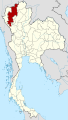
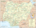
Nigeria location map[edit]
-
 I want something like this, but for Nigeria
 -
 Current location map for Nigeria
 -
 State outlines can come from this map
 -
 We also have this map, if it is helpful


Article(s): Lagos, Abuja, hundreds more city articles
Request: Most African countries have sophisticated-looking location maps (see commons:Category:Location maps of Africa, but Nigeria's still looks pretty sad. Could someone make a location map like the one we have for Sudan? Calliopejen1 (talk) 19:50, 2 February 2010 (UTC)
Graphist opinion(s): You could try to contact NNW directly. He made many (if not most) of the location maps in the style of the Sudan map. There is also a project on de-wikipedia to create location maps in a uniform style, so sooner or later Nigeria is going to be covered. bamse (talk) 23:01, 2 February 2010 (UTC)
- User:Dr. Blofeld already contacted him, and he said he was too busy to do it at the moment. Just asking here to see if someone could speed up the process. :) Calliopejen1 (talk) 02:18, 3 February 2010 (UTC)
I have started working on this, but it may take a while... Uwe Dedering--19:53, 4 February 2010 (UTC) —Preceding unsigned comment added by Uwe Dedering (talk • contribs)

![]() Done Uwe Dedering13:14, 10 February 2010 (UTC)
Done Uwe Dedering13:14, 10 February 2010 (UTC)
- Thanks so much!! Calliopejen1 (talk) 13:25, 10 February 2010 (UTC)
Cucuteni-Trypillian culture Map[edit]
-
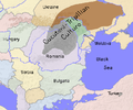 Original raster image (not very high quality) to create separate map in SVG format from. Look at file history for larger view.
 -
 Probable base map (would need to be cropped to use as base).
 -
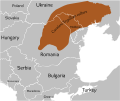 Modernized and SVGified.


Article(s): Template:Infobox Cucuteni-Trypillian historical era
Request: Do something with them/Create according to the provided sources... NativeForeigner Talk/Contribs 18:14, 23 January 2010 (UTC)
Graphist opinion:
![]() Done
Took 6 hours to make! Was this how you intended it to be? --Shandristhe azylean 22:50, 11 February 2010 (UTC)
Sorry it took you so long :| NativeForeigner Talk/Contribs 03:06, 13 February 2010 (UTC)
Done
Took 6 hours to make! Was this how you intended it to be? --Shandristhe azylean 22:50, 11 February 2010 (UTC)
Sorry it took you so long :| NativeForeigner Talk/Contribs 03:06, 13 February 2010 (UTC)
Sovereign Military Order of Malta[edit]

Article(s): Sovereign Military Order of Malta
Request: This image is outdated as it shows Canada in the wrong colour designation, as per this source and the main page. It needs to be updated. Thank You. Outback the koala (talk) 21:23, 18 February 2010 (UTC)
Graphist opinion: ![]() Rannpháirtí anaithnid I presume you mean for Canada to be red. Can you please explicitly state this in future as I am not aware of the issues involved. -- RA (talk) 17:58, 20 February 2010 (UTC)
Rannpháirtí anaithnid I presume you mean for Canada to be red. Can you please explicitly state this in future as I am not aware of the issues involved. -- RA (talk) 17:58, 20 February 2010 (UTC)
- OK, thank you. Good work. Outback the koala (talk) 06:36, 22 February 2010 (UTC)