
Wikipedia:Graphics Lab/Map workshop/Archive/Jan 2012
Stale[edit]
Fix incorrect United States county maps[edit]
-
 Map 1
Map 1

Article(s): County, County (United States), and many derivative works of the file, including [1], [2], and [3], plus others found at [4].
Request: This map (and consequently most likely all of it's derivative works) have sometimes significant errors/generalizations of county borders. Examples of counties affected are the northwestern Sedgwick County, Kansas, northeastern Harvey County, Kansas, most of the border of Wabaunsee County, Kansas, most of Osage County, Oklahoma, and Denver County, Colorado. Please either fix all the county borders in the map or recreate the map with correct county borders. Thanks in advance, Ks0stm (T•C•G•E) 22:13, 20 October 2011 (UTC)
Graphist opinion(s): If someone with GIS skills wants to remake these (which would probably be easier than fixing them), the file needed to do so is available here. Kmusser (talk) 03:42, 21 October 2011 (UTC)
alt world map[edit]
Article(s): Ace Combat
Request: Please vectorize this map...: Ace_Combat_Map.jpg Drax90 (talk) 14:11, 6 November 2011 (UTC)
Graphist opinion(s):
Serbia demographics 2002[edit]
.png)
Article(s): Serbia
Request: Can someone please vectorie this map and put it on wikipedia serbia page... Drax90 (talk) 17:36, 9 November 2011 (UTC)
Graphist opinion(s):
The Imperial Powers 1939 Map[edit]

Article(s): Pacific War
Request: please can someone update this map using this map of japanese advances by 1942:http://en.wikipedia.org/wiki/File:Second_world_war_asia_1937-1942_map_en6.png... Drax90 (talk) 17:35, 16 October 2011 (UTC)
- So you want a svg-map of the 1942-map with the first map as a base. Wereldburger758 (talk) 05:43, 17 October 2011 ::
- (UTC)yes,to show the expansion of japan in 1942 Drax90 (talk) 19:22, 26 October 2011 (UTC)
Graphist opinion(s):
update map of Azerbaijan[edit]
-
 Map showing districts of Azerbaijan. The borders are correct, but the shading is not.

Article(s): Administrative divisions of Azerbaijan
Request: Update the map to look like the more up-to-date Russian version, which has a more accurate depiction of the territory of the Nagorno-Karabakh Republic. JaGatalk 16:39, 14 November 2011 (UTC)
Graphist opinion(s):
![]() Request taken by Golbez. - What have those Russians done to my map? :P Seeing as how I made the original, I'll take this on. It may not be done before December but I'll do it. I might also disagree with them coloring in the exclaves; while they are currently occupied by the other nation, they are not (so far as I know) officially claimed/annexed. Might as well use a better color scheme then my former "barbie pink + baby poop brown" as well. --Golbez (talk) 16:54, 14 November 2011 (UTC)
Request taken by Golbez. - What have those Russians done to my map? :P Seeing as how I made the original, I'll take this on. It may not be done before December but I'll do it. I might also disagree with them coloring in the exclaves; while they are currently occupied by the other nation, they are not (so far as I know) officially claimed/annexed. Might as well use a better color scheme then my former "barbie pink + baby poop brown" as well. --Golbez (talk) 16:54, 14 November 2011 (UTC)
- check out also http://commons.wikimedia.org/wiki/Category:SVG_labeled_maps_of_administrative_divisions_of_Azerbaijan_(location_map_scheme) --TUBS (talk) 14:10, 27 September 2012 (UTC)
Resolved[edit]
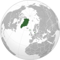
*urgent* - new Kingdom of Denmark orthographic map[edit]
-
 Kingdom of Denmark map
 -
 New map
_(Europe_centered).svg)
.svg)
Article(s): Denmark (merging with Kingdom of Denmark article), Rigsfællesskabet
Request: Please can you copy this map, keeping the Faroe Islands highlighted or circled (very important that the Faroes remain visible somehow) and turn it into a green&grey coloured map. See File:Denmark (orthographic projection).svg - something like that (you could just use that map and colour in Greenland and add on the Faroe Islands). Peter (Talk page) 12:56, 14 January 2012 (UTC)
Graphist opinion(s):
![]() Request taken by Orionist.
Request taken by Orionist.
 Done I didn't emphasize the Faroes as much as the original, as I didn't want them to overpower mainland Denmark. Regards. -- Orionist ★ talk 16:36, 14 January 2012 (UTC)
Costa Concordia shipwreck route between 'le Scole' rocks[edit]
-
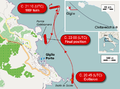 Our current map
.png)
Article(s): Costa Concordia disaster
Request: Please help make a better map based on these new reliable sources [5] and [6] indicating that the ship first ran aground between the rocks at 'le Scole' point before capsizing at the location currently indicated on the map.
People have complained that the smaller inset of Italy is too small. I recommend using more space for the insets or stacking the larger scale, smaller inset below the island location inset at the top right if necessary. Selery (talk) 14:25, 15 January 2012 (UTC)
Graphist opinion(s): ![]() Done by User:J. J. Hornung
Done by User:J. J. Hornung
Simple SVG modification[edit]
-
 Indiana time zones according to the tz database

Article(s): Time in Indiana, several others
Request: Could you please make the two hues of yellow the same color? Every page that uses this image uses it to illustrate the tz database boundaries (except for one that concentrates solely on the red counties), and the divide between the two yellowish colors is not reflected in that database, so it's confusing to have two different shades for the same region. If my words aren't clear, you can see what I mean by going to Time in Indiana; the two colors (#ffff00 and #ffff66) that I'd like to see merged are the two that appear jointly in the leftmost column. I'd ask the uploader, but he seems to have retired, and I don't have SVG-editing software on my computer. Please note that multiple versions of this image have been uploaded on the same title, so at least to me it seems reasonable to upload the new version under the same title. Nyttend (talk) 04:54, 24 January 2012 (UTC)
Graphist opinion(s): Why not go to Commons and revert back to the "18:41, 8 October 2011" version when it was all the same shade? BTW: everyone has SVG-editing software, just download the .svg link from the screen, open it with Notepad or similar, change any hex codes carefully, save, open with a browser to be sure it works, done. ;) Ma®©usBritish [chat] 05:37, 24 January 2012 (UTC)
- I considered that, but if you compare the two most recent revisions, you'll see that a bunch of other colors were changed in the most recent version, and I believe those changes to be beneficial. Nyttend (talk) 06:06, 24 January 2012 (UTC)
- Okay, understood. Will that new one do it? Ma®©usBritish [chat] 06:10, 24 January 2012 (UTC)
- Following your instructions, I just now modified it in Notepad and reuploaded, and we did the same thing but went with different colors :-\ Either one will work. Thanks for the instructions; I thought that SVGs could only be edited in dedicated image editors, just like non-vector images. Nyttend (talk) 06:13, 24 January 2012 (UTC)
- Okay, glad you figured it.. will mark this as done.. I'm not on the G.Labs team, but saves them a job. Ma®©usBritish [chat] 06:22, 24 January 2012 (UTC)
- Following your instructions, I just now modified it in Notepad and reuploaded, and we did the same thing but went with different colors :-\ Either one will work. Thanks for the instructions; I thought that SVGs could only be edited in dedicated image editors, just like non-vector images. Nyttend (talk) 06:13, 24 January 2012 (UTC)
- Okay, understood. Will that new one do it? Ma®©usBritish [chat] 06:10, 24 January 2012 (UTC)
![]() Done – Ma®©usBritish [chat] 06:22, 24 January 2012 (UTC)
Done – Ma®©usBritish [chat] 06:22, 24 January 2012 (UTC)
LTE deployment locations[edit]
-
 done
done

Article: 3GPP Long Term Evolution
Request: The referenced image above is copyrighted and will be deleted soon. The source image can be retrieved at http://www.gsacom.com/news/gsa_324.php4.Mblumber (talk) 00:30, 4 December 2011 (UTC)
Graphist opinion(s):
![]() Request taken by Orionist.
Request taken by Orionist.
- Done I updated the existent map as per the most recent LTE evolution map with all the details I could discern at that low quality. It's possible that I missed a couple of small countries that should be colored dark blue. If you know of any I can add it right away. Regards. -- Orionist ★ talk 14:35, 8 January 2012 (UTC)
Germany 1937[edit]
Article(s): Various
Request: I have been using the Template:Location map Germany 1937 as part of an effort to improve the articles on German WWII POW camps. However I have noticed that the displayed locations (the red dot) appears slightly north-west of where they should be. For example the article on Stalag Luft I shows the camp as being in the Baltic Sea rather than on the coast, and Stalag IV-C appears to be in Germany itself rather than just over the border in Czechoslovakia. Can someone fix it? dawkeye (talk) 14:34, 4 December 2011 (UTC)
Graphist opinion(s): Problem is with the template - the coordinates in the template don't match the map, would need the map author or at least the map projection to know what they should be. I sort of eyeballed them and it looks better, Stalag Luft I comes out on the coast, but Stalag IV-C still looks like it's in Germany. Kmusser (talk) 15:34, 4 December 2011 (UTC)
yugoslav wars map 1995[edit]
-
 Original
 -
 SVG
SVG


Article(s): Yugoslav Wars
Request: Can someone please vectorize this map?... Drax90 (talk) 15:14, 6 December 2011 (UTC)
Graphist opinion(s):
![]() Done – linked in Gallery above, sorry if it's not perfect, haven't been doing vectors for long. Ma®©usBritish[chat] 04:47, 27 January 2012 (UTC)
Done – linked in Gallery above, sorry if it's not perfect, haven't been doing vectors for long. Ma®©usBritish[chat] 04:47, 27 January 2012 (UTC)
Incorrectly named map[edit]
-
 This map appears to be named incorrectly. It should have 1863 in the title and not 1865.
 -
 Map of US in 1863
 -
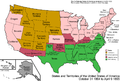 Map of US in 1864
 -
 Map of US in 1865
.png)


Article(s): American Civil War History of the United States (1849–1865)
Request: The map "US_Secession_map_1865_(BlankMap_derived)" appears to be misnamed. The map actually appears to be a map of the U.S. in 1863 and not the U.S. in 1865 -- see blue section. Can the file be renamed correctly? See Territorial evolution of the United States for more maps.
Graphist opinion(s):
![]() Done -- Orionist ★ talk 08:26, 10 January 2012 (UTC)
Done -- Orionist ★ talk 08:26, 10 January 2012 (UTC)
Bulgarian map image needs correction[edit]
In article "Military history of Bulgaria during World War II"
Map text for 'Bulgaria during World War II' - needs correction
'Presen' needs to be changed to 'Present' — Preceding unsigned comment added by Robfwoods (talk • contribs) 08:17, 25 December 2011 (UTC)
File:ElectoralCollege1804.svg[edit]
-
 Electoral college map for the 1804 United States presidential election.

![[1]](https://commons.wikimedia.org/wiki/File:KS-NE_County_map.svg)
![[2]](https://commons.wikimedia.org/wiki/File:KS-MO_County_map.svg)
![[3]](https://commons.wikimedia.org/wiki/File:KS-CO-NE_county_map.svg)
.svg)
Request: I am colorblind and for the life of me can't make out the states that Jefferson and Pinckney carried. If somebody could change the color scheme to add more contrast, I (and others, I'm sure) would be most appreciative. ThemFromSpace 20:53, 19 January 2012 (UTC)
Graphist opinion(s):
![]() Done Ma®©usBritish[chat] 20:45, 26 January 2012 (UTC)
Done Ma®©usBritish[chat] 20:45, 26 January 2012 (UTC)